

Hail Map for Danville, IN August 9, 2012
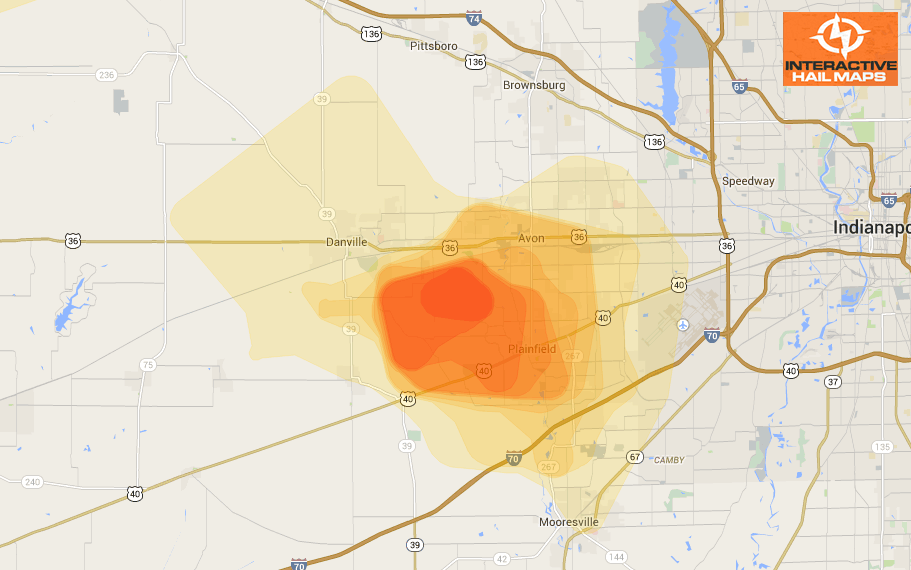
Here is a heat map for a hail storm that hit just outside of Indianapolis on August 9, 2012. The most intense hail hit just east of Danville. Use Interactive Hail Maps to pinpoint hail locations live and zoom all the way to street view. Find the smaller hail storms others are missing. Subscribe to Interactive Hail Maps to receive Unlimited Full Screen Hail Maps, nationwide.
Cities Most Affected by Hail Storms of 8/9/2012
| Hail Size | Demographics of Zip Codes Affected | ||||||
|---|---|---|---|---|---|---|---|
| City | Count | Average | Largest | Pop Density | House Value | Income | Age |
| Remington, IN | 3 | 1.75 | 1.75 | 21 | $86k | $43.3k | 40.0 |
| Decorah, IA | 2 | 1.88 | 2.00 | 38 | $97k | $39.5k | 37.5 |
| Gambier, OH | 2 | 1.75 | 1.75 | 39 | $109k | $48.0k | 21.8 |
| Morocco, IN | 1 | 2.75 | 2.75 | 11 | $75k | $35.1k | 43.3 |
| Camden, IN | 1 | 2.00 | 2.00 | 23 | $73k | $40.4k | 41.4 |
| Ladoga, IN | 1 | 1.75 | 1.75 | 26 | $88k | $44.7k | 40.0 |
| Bringhurst, IN | 1 | 1.75 | 1.75 | 42 | $100k | $57.6k | 39.9 |
| Wilmington, OH | 1 | 1.75 | 1.75 | 129 | $107k | $40.3k | 38.7 |
| Alexandria, KY | 1 | 1.75 | 1.75 | 338 | $119k | $53.1k | 38.2 |

Connect with Interactive Hail Maps