

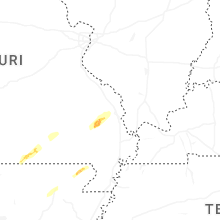
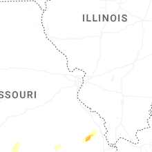
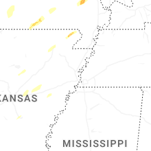
Hail Map for Sunday, April 20, 2025

Number of Impacted Households on 4/20/2025
0
Impacted by 1" or Larger Hail
0
Impacted by 1.75" or Larger Hail
0
Impacted by 2.5" or Larger Hail
Square Miles of Populated Area Impacted on 4/20/2025
0
Impacted by 1" or Larger Hail
0
Impacted by 1.75" or Larger Hail
0
Impacted by 2.5" or Larger Hail
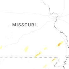
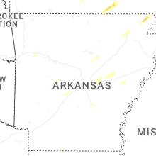
Cities Most Affected by Hail Storms of 4/20/2025
| Hail Size | Demographics of Zip Codes Affected | ||||||
|---|---|---|---|---|---|---|---|
| City | Count | Average | Largest | Pop Density | House Value | Income | Age |
| Alton, MO | 1 | 2.00 | 2.00 | 16 | $42k | $20.4k | 43.9 |
Hail and Wind Damage Spotted on 4/20/2025
Filter by Report Type:Hail ReportsWind Reports
Missouri
| Local Time | Report Details |
|---|---|
| 1:31 PM CDT | Roof partially peeled off home. 18 to 20 inch diameter tree branches snapped from multiple trees about 3 to 4 feet from the groun in callaway county MO, 19 miles SE of Columbia, MO |
| 1:34 PM CDT | Corrects previous tstm wnd dmg report from 1 sw guthrie. roof partially peeled off home. 18 to 20 inch diameter tree branches snapped from multiple trees about 3 to 4 f in callaway county MO, 19 miles SE of Columbia, MO |
| 1:34 PM CDT | Report of multiple trees sustaining damage of unknown exten in callaway county MO, 17.9 miles SE of Columbia, MO |
| 1:34 PM CDT | Roof of house damage in callaway county MO, 18.3 miles SE of Columbia, MO |
| 2:10 PM CDT | A row of power poles snapped at ivy and county road 275 in carl junctio in jasper county MO, 60.1 miles SE of Chanute, KS |
| 2:10 PM CDT | Corrects previous tstm wnd dmg report from carl junction. early reports coming in of several trees and powerlines down in carl junction. some building damage as well. p in jasper county MO, 60 miles SE of Chanute, KS |
| 2:10 PM CDT | A roof off a house on county lane 265 and highway 9 in jasper county MO, 60.6 miles ESE of Chanute, KS |
| 2:17 PM CDT | Early reports coming in of several trees and powerlines down in carl junction. some building damage as well. possible tornad in jasper county MO, 60 miles SE of Chanute, KS |
| 2:23 PM CDT | Trees downed and a damage to a bar in jasper county MO, 62.2 miles ESE of Chanute, KS |
| 2:24 PM CDT | House and barn damage on county road 210 between thorn road and redbud roa in jasper county MO, 61.2 miles ESE of Chanute, KS |
| 2:24 PM CDT | Barn is down west of jasper at highway h and highway in jasper county MO, 61.2 miles W of Springfield, MO |
| 2:25 PM CDT | Barn destroyed and multiple power lines down. tornado possibl in barton county MO, 59.8 miles WNW of Springfield, MO |
| 2:26 PM CDT | A public weather station measured a 68 mph gust 7 miles west southwest of goodma in mcdonald county MO, 76.5 miles WSW of Springfield, MO |
| 2:38 PM CDT | Early reports coming in of trees and powerlines down in lamar. damage assessment ongoing. power out in town. damage extends to the northeast of town. possible tornad in barton county MO, 57.2 miles WNW of Springfield, MO |
| 2:39 PM CDT | Large tree and branches down on a house. powerlines down. tornado possibl in barton county MO, 56.7 miles WNW of Springfield, MO |
| 2:39 PM CDT | Trees uprooted... power poles down and broken... 3 inch limbs broken. tornado possibl in barton county MO, 57.2 miles WNW of Springfield, MO |
| 2:39 PM CDT | Tornado siren was blown down. tornado possibl in barton county MO, 56.5 miles WNW of Springfield, MO |
| 2:50 PM CDT | Trees and powerlines down. tornado possibl in barton county MO, 54.2 miles WNW of Springfield, MO |
| 2:57 PM CDT | Quarter sized hail reported near Wentworth, MO, 47.8 miles WSW of Springfield, MO, up to quarter size hail just south of wentworth. |
| 3:00 PM CDT | Some powerlines down in monet in barry county MO, 40.5 miles WSW of Springfield, MO |
| 3:00 PM CDT | Uprooted trees at state highway 97 and state highway c in cedar county MO, 54.2 miles NW of Springfield, MO |
| 3:00 PM CDT | Numerous trees down across the monett are in barry county MO, 40 miles WSW of Springfield, MO |
| 3:10 PM CDT | Tree down south of state highway 96 on highway 9 in lawrence county MO, 36.4 miles W of Springfield, MO |
| 3:16 PM CDT | Delayed report... time estimated by radar. line across 174 west of mai in lawrence county MO, 29.8 miles WSW of Springfield, MO |
| 3:20 PM CDT | Multiple trees down blocking road on highway w in dade county MO, 27.5 miles WNW of Springfield, MO |
| 3:25 PM CDT | Delayed report... time estimated by radar. tree limbs down on two vehicles and the corner of a house... estimated tree size is around 1 to 1 and a half feet in diameter in barry county MO, 47.3 miles SSW of Springfield, MO |
| 3:52 PM CDT | Asos station ksgf springfield asos measured 59mph wind gus in greene county MO, 5.1 miles WNW of Springfield, MO |
| 4:02 PM CDT | Trees and powerlines down in holliste in taney county MO, 40.8 miles S of Springfield, MO |
| 4:05 PM CDT | Tree down over a mobile home in rockaway beac in taney county MO, 35.8 miles SSE of Springfield, MO |
| 4:05 PM CDT | Trees and powerlines down. tree down on a mobile hom in taney county MO, 35.8 miles SSE of Springfield, MO |
| 4:08 PM CDT | Tree fell in seligma in barry county MO, 59.6 miles SW of Springfield, MO |
| 4:09 PM CDT | A five inch tree was down in forsyt in taney county MO, 37.3 miles SSE of Springfield, MO |
| 4:10 PM CDT | An 8 inch tree down at highway 160 and highway 76 towards taneyvill in taney county MO, 37.6 miles SSE of Springfield, MO |
| 4:14 PM CDT | Delayed report... time estimated by radar. tree across the roadway... cant be moved by hand estimated 2ft diamete in christian county MO, 15 miles SE of Springfield, MO |
| 4:15 PM CDT | Mesonet station fw9620 pumpkin center measured a 58mph wind gus in dallas county MO, 39.2 miles NNE of Springfield, MO |
| 4:17 PM CDT | Tree down across red bridge roa in christian county MO, 26.5 miles SSE of Springfield, MO |
| 4:19 PM CDT | Trees down across the roa in christian county MO, 31 miles SSE of Springfield, MO |
| 4:26 PM CDT | Several trees down. tornado possibl in douglas county MO, 33.7 miles SE of Springfield, MO |
| 4:29 PM CDT | Public weather station measured 70.0 mph wind gus in dallas county MO, 49.3 miles NNE of Springfield, MO |
| 4:34 PM CDT | Tree down in goodhope are in douglas county MO, 34.1 miles SE of Springfield, MO |
| 4:40 PM CDT | Mesonet station gw3917 versaille in morgan county MO, 41.9 miles SW of Columbia, MO |
| 4:40 PM CDT | Tree and powerline down on osage beach parkwa in camden county MO, 59.4 miles SSW of Columbia, MO |
| 4:40 PM CDT | Small shed destroyed at highway a and highway in douglas county MO, 40.3 miles ESE of Springfield, MO |
| 4:43 PM CDT | Tree down on state highway in douglas county MO, 37.3 miles ESE of Springfield, MO |
| 4:43 PM CDT | Tree down in av in douglas county MO, 39.2 miles ESE of Springfield, MO |
| 4:43 PM CDT | Significant barn damage relayed to us at state highway d and bluebird road. possible tornad in morgan county MO, 40.5 miles SW of Columbia, MO |
| 4:45 PM CDT | Corrects previous tstm wnd dmg report from clarksburg. multiple 6-8inch diameter tree limbs dow in moniteau county MO, 26.2 miles SW of Columbia, MO |
| 4:50 PM CDT | Storm damage reported in moniteau county MO, 25 miles SSW of Columbia, MO |
| 4:50 PM CDT | Damage to a barn at highway 38 and blue stem roa in webster county MO, 29.6 miles ENE of Springfield, MO |
| 4:55 PM CDT | Large oak tree uprooted. other smaller oak trees snappe in wright county MO, 42 miles E of Springfield, MO |
| 5:16 PM CDT | Storm damage reported in boone county MO, 11.6 miles SSE of Columbia, MO |
| 5:17 PM CDT | Storm damage reported in callaway county MO, 26.7 miles SSE of Columbia, MO |
| 5:18 PM CDT | Roof damage to parkade baptist churc in boone county MO, 1.3 miles NNW of Columbia, MO |
| 5:18 PM CDT | Tree damage varying from downed limbs to uprooted tree in boone county MO, 1.9 miles N of Columbia, MO |
| 5:19 PM CDT | Small outbuildings damage in boone county MO, 3.5 miles NE of Columbia, MO |
| 5:20 PM CDT | Estimated wind in boone county MO, 1.4 miles W of Columbia, MO |
| 5:20 PM CDT | An outbuilding and a warehouse were significantly damaged... per image in boone county MO, 5.6 miles NE of Columbia, MO |
| 5:26 PM CDT | Corrects previous tstm wnd gst report from 7 ese columbia. at columbia-bradford mo ag sit in boone county MO, 7.1 miles ESE of Columbia, MO |
| 5:33 PM CDT | At columbia-bradford mo ag sit in boone county MO, 7.1 miles ESE of Columbia, MO |
| 5:51 PM CDT | Down tree on state highway n near graham cave state par in montgomery county MO, 39.1 miles E of Columbia, MO |
| 6:10 PM CDT | Vandalia mo ag sit in audrain county MO, 50.4 miles ENE of Columbia, MO |
| 6:10 PM CDT | Estimated with near-zero visibilit in monroe county MO, 53.2 miles S of Kahoka, MO |
| 6:10 PM CDT | 2ft diameter tree snapped at the bas in montgomery county MO, 42.1 miles ENE of Columbia, MO |
| 6:15 PM CDT | Damage to sheds. damage to a support column and the wall of a hom in pike county MO, 58 miles ENE of Columbia, MO |
| 6:35 PM CDT | Multiple reports of damage including trailers destroyed near hannibal regional hospita in marion county MO, 51.1 miles SSE of Kahoka, MO |
| 6:38 PM CDT | From two sources west of hannibal... m in marion county MO, 50.1 miles SSE of Kahoka, MO |
| 6:59 PM CDT | Hen Egg sized hail reported near Alton, MO, 65.1 miles S of Salem, MO, relayed via media. size estimated from picture. time estimated from radar. |
| 7:40 PM CDT | Powerlines down... per e in st. francois county MO, 54.4 miles SSW of Saint Louis, MO |
| 7:40 PM CDT | Power lines down at camilla st. and polk ave. via e in st. francois county MO, 56.1 miles ENE of Salem, MO |
| 7:50 PM CDT | Via trained spotte in st. francois county MO, 59.2 miles SSW of Saint Louis, MO |
Kansas
| Local Time | Report Details |
|---|---|
| 1:55 PM CDT | Large tree limbs down in baxter springs... kansa in cherokee county KS, 60.5 miles SE of Chanute, KS |
| 2:00 PM CDT | Multiple power poles down just north of galen in cherokee county KS, 61 miles SE of Chanute, KS |
| 2:03 PM CDT | Multiple trees down and outbuildings destroyed on messer road and 110th street. debris thrown different directions. possible tornad in cherokee county KS, 58.2 miles SE of Chanute, KS |
Arkansas
| Local Time | Report Details |
|---|---|
| 2:37 PM CDT | Several homes damaged; time estimated from rada in washington county AR, 50.5 miles NNE of Fort Smith, AR |
| 2:45 PM CDT | Tree limbs downed that also took down a power line. pic from a viewer shared with us via broadcast media. time estimated from rada in washington county AR, 57.9 miles NNE of Fort Smith, AR |
| 2:55 PM CDT | Large tree limb downed onto a vehicle. time estimated by rada in benton county AR, 67.3 miles NNE of Fort Smith, AR |
| 5:35 PM CDT | Large tree reported to be blown down and covering roadwa in perry county AR, 28.9 miles WNW of Little Rock, AR |
| 7:13 PM CDT | Trees reported blown down. report relayed by ham radi in lonoke county AR, 23.5 miles NNE of Little Rock, AR |
| 8:32 PM CDT | Power lines reported down along ar-state highway 34 near the intersection with us highway 67 to the northeast of the center of walnut ridg in lawrence county AR, 81.6 miles NW of Memphis, TN |
Illinois
| Local Time | Report Details |
|---|---|
| 6:50 PM CDT | Power poles down along il-57 in near hull... i in pike county IL, 53.9 miles SSE of Kahoka, MO |
| 6:51 PM CDT | Several trees snapped or uproote in adams county IL, 49.4 miles SSE of Kahoka, MO |
| 6:53 PM CDT | Barn destroyed per e in adams county IL, 28.6 miles SSE of Kahoka, MO |
| 7:00 PM CDT | Damage to an old school gym roo in adams county IL, 40 miles SE of Kahoka, MO |
| 7:05 PM CDT | Picture received of a tree snapped and blown ove in adams county IL, 43.2 miles SE of Kahoka, MO |
| 7:13 PM CDT | Relayed by 911. damage to a roof. time of the event estimated using rada in hancock county IL, 37 miles ESE of Kahoka, MO |
| 7:36 PM CDT | 70 mph measured wind gust and small branches 1 inch in diameter broken. time estimated by rada in mcdonough county IL, 53.9 miles E of Kahoka, MO |
| 7:41 PM CDT | Large tree down across n county 2 hwy north of e workman r in fulton county IL, 48.8 miles SW of Peoria, IL |
| 7:46 PM CDT | Large tree blown down over roof of house with siding damag in mcdonough county IL, 54.9 miles E of Kahoka, MO |
| 7:50 PM CDT | Several shingles lost from roof of house. time estimated by rada in mcdonough county IL, 56.4 miles E of Kahoka, MO |
| 8:00 PM CDT | Metal in power lines on lrc r in monroe county IL, 24 miles S of Saint Louis, MO |
| 8:05 PM CDT | Power poles dow in monroe county IL, 21.4 miles S of Saint Louis, MO |
| 8:10 PM CDT | 60-65 mph wind gusts reporte in fulton county IL, 36.2 miles WSW of Peoria, IL |
| 8:11 PM CDT | Power poles dow in monroe county IL, 24 miles SSE of Saint Louis, MO |
| 8:12 PM CDT | Near-zero visibility also reporte in monroe county IL, 20.6 miles S of Saint Louis, MO |
| 8:14 PM CDT | Collapsed shed... power lines down. time estimated from rada in st. clair county IL, 16.2 miles SSE of Saint Louis, MO |
| 8:25 PM CDT | Tree down on a power line along county road 750 in mason county IL, 38.8 miles SSW of Peoria, IL |
| 8:36 PM CDT | Spotter has an anemometer reading of 65 mph with a 4 inch tree limb dow in henry county IL, 58.4 miles NW of Peoria, IL |
| 8:50 PM CDT | Pine tree top blown off. time estimated from radar dat in henry county IL, 39.7 miles NW of Peoria, IL |
| 8:57 PM CDT | 6 inch diameter tree limbs down... and about a 70 foot section of a barn wall was blown ou in tazewell county IL, 13.4 miles SE of Peoria, IL |
| 8:58 PM CDT | Top of a grain bin blown off near the intersection of washington and robinson road in tazewell county IL, 12.5 miles SE of Peoria, IL |
| 8:59 PM CDT | Soffit came loose on a hous in stark county IL, 25.3 miles NNW of Peoria, IL |
| 9:09 PM CDT | Trees down over train tracks. probable tornado damag in henry county IL, 63.3 miles NNW of Peoria, IL |
| 9:12 PM CDT | 6 inch diameter tree branches down. time estimated from radar dat in bureau county IL, 32.3 miles N of Peoria, IL |
| 10:22 PM CDT | Tree down blocking old highway 50 at country club roa in clay county IL, 57.4 miles S of Mattoon, IL |
Iowa
| Local Time | Report Details |
|---|---|
| 7:12 PM CDT | 5 power poles snappe in des moines county IA, 38.2 miles NE of Kahoka, MO |
| 7:14 PM CDT | Corrects previous tornado report from 1 sse beaverdale. dot metal building/shed collapse in des moines county IA, 38.9 miles NE of Kahoka, MO |
| 7:14 PM CDT | Estimated wind speeds of 55 to 60 mp in des moines county IA, 39.4 miles NE of Kahoka, MO |
| 7:17 PM CDT | Measured a 53 knot gust. also occurred at 714 pm cd in des moines county IA, 40.1 miles NE of Kahoka, MO |
Connect with Interactive Hail Maps