

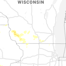
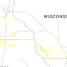
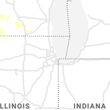
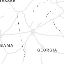
Hail Map for Wednesday, July 17, 2019

Number of Impacted Households on 7/17/2019
0
Impacted by 1" or Larger Hail
0
Impacted by 1.75" or Larger Hail
0
Impacted by 2.5" or Larger Hail
Square Miles of Populated Area Impacted on 7/17/2019
0
Impacted by 1" or Larger Hail
0
Impacted by 1.75" or Larger Hail
0
Impacted by 2.5" or Larger Hail


Cities Most Affected by Hail Storms of 7/17/2019
| Hail Size | Demographics of Zip Codes Affected | ||||||
|---|---|---|---|---|---|---|---|
| City | Count | Average | Largest | Pop Density | House Value | Income | Age |
| Gillette, WY | 6 | 1.92 | 2.25 | 15 | $100k | $46.7k | 31.9 |
| Spearfish, SD | 1 | 3.00 | 3.00 | 62 | $98k | $30.2k | 38.6 |
| Piedmont, SD | 1 | 2.50 | 2.50 | 23 | $88k | $41.5k | 41.4 |
| Beulah, WY | 1 | 2.50 | 2.50 | 0 | $134k | $29.5k | 43.3 |
| Burnsville, MN | 1 | 2.00 | 2.00 | 2473 | $153k | $58.3k | 35.9 |
| Bottineau, ND | 1 | 1.75 | 1.75 | 12 | $55k | $30.5k | 48.1 |
| Prior Lake, MN | 1 | 1.75 | 1.75 | 545 | $179k | $77.1k | 38.9 |
| Lance Creek, WY | 1 | 1.75 | 1.75 | 0 | $33k | $30.2k | 53.2 |
Hail and Wind Damage Spotted on 7/17/2019
Filter by Report Type:Hail ReportsWind Reports
States Impacted
Iowa, Alabama, Virginia, Wisconsin, Massachusetts, South Carolina, Connecticut, Florida, Missouri, New York, North Carolina, Georgia, Illinois, Rhode Island, Maryland, Texas, District of Columbia, Pennsylvania, North Dakota, Wyoming, New Jersey, Minnesota, Arizona, Delaware, South Dakota, West Virginia, Kentucky, NebraskaIowa
| Local Time | Report Details |
|---|---|
| 7:05 AM CDT | 3 powerline poles blown ove in sioux county IA, 32.4 miles SSE of Sioux Falls, SD |
| 7:06 AM CDT | 10 mature trees blown over... with the tops broke in sioux county IA, 33.4 miles SSE of Sioux Falls, SD |
| 7:06 AM CDT | Machine shed doors blown in... and backwall blown out with debris going out into the fiel in sioux county IA, 33.4 miles SSE of Sioux Falls, SD |
| 7:10 AM CDT | Large trees downed by wind gust in sioux county IA, 38.7 miles SE of Sioux Falls, SD |
| 7:15 AM CDT | Truck blown over west of tow in sioux county IA, 42.5 miles SE of Sioux Falls, SD |
| 7:55 AM CDT | Medium tree knocked ove in o'brien county IA, 49.5 miles NW of Storm Lake, IA |
| 8:15 AM CDT | Pea-sized hail... and a few tree branches dow in woodbury county IA, 37.6 miles WSW of Storm Lake, IA |
| 9:55 AM CDT | 10-20 trees blown onto builds... roads... and cars. fire hall damaged. 3 grain bins destroyed. machine shed destroyed. winds estimated at 70 mp in shelby county IA, 34.6 miles NE of Omaha, NE |
| 9:58 AM CDT | Crops laid over along county road f58. time estimate in shelby county IA, 33.4 miles NE of Omaha, NE |
| 10:00 AM CDT | Tree limbs blown dow in shelby county IA, 34.5 miles NE of Omaha, NE |
| 10:08 AM CDT | Quarter sized hail reported near Harlan, IA, 41.5 miles NE of Omaha, NE |
| 10:08 AM CDT | Storm damage reported in shelby county IA, 41.5 miles NE of Omaha, NE |
| 10:15 AM CDT | Quarter sized hail reported near Harlan, IA, 38.6 miles NE of Omaha, NE, time estimated. |
| 10:35 AM CDT | Trees and power lines blown down. wind speeds estimated at 60 mp in shelby county IA, 51.1 miles ENE of Omaha, NE |
| 2:12 PM CDT | Wayland fire chief reports that numerous trees were down in wayland. a few structures had their roofs ripped off and a horse barn was destroyed in the are in henry county IA, 50.4 miles N of Kahoka, MO |
| 2:25 PM CDT | Several large trees uprooted or split in half... around 15-18 inches in diameter. several carports also damage in van buren county IA, 30.9 miles N of Kahoka, MO |
| 2:25 PM CDT | Power poles down in the area and no power at the residence. four inch diameter tree branches broken and corn was blown dow in van buren county IA, 29 miles N of Kahoka, MO |
| 2:40 PM CDT | Tool shed roof blown off. wind estimate was 60-70 mph. time estimated from rada in lee county IA, 22.4 miles N of Kahoka, MO |
| 2:42 PM CDT | Large... 14-inch tree limb fell on house. debris like garbage cans flying aroun in henry county IA, 47.4 miles NNE of Kahoka, MO |
| 3:00 PM CDT | Roof damage to the gregory manufacturing co north of montrose. picture received via social media. time estimated from rada in lee county IA, 18.4 miles NE of Kahoka, MO |
| 3:05 PM CDT | No damage... observed in an open are in des moines county IA, 46.9 miles NE of Kahoka, MO |
| 3:43 PM CDT | Storm damage reported in des moines county IA, 39.3 miles NE of Kahoka, MO |
Alabama
| Local Time | Report Details |
|---|---|
| 7:47 AM CDT | Few trees down in the scott bridge area. tim estimated from rada in franklin county AL, 32.8 miles SSW of Florence, AL |
| 12:30 PM CDT | Trees down near the railroad tracks and finley island rd. in decatu in morgan county AL, 37.5 miles ESE of Florence, AL |
Virginia
| Local Time | Report Details |
|---|---|
| 2:10 PM EDT | Emergency management reports approximately 50 to 60 large trees down on the campus of vmi and washington and lee university likely due to a wet microburst. time from ra in city of lexington county VA, 44.8 miles NE of Roanoke, VA |
| 3:14 PM EDT | Multiple reports of trees down in crozett in albemarle county VA, 69.4 miles NW of Richmond, VA |
| 3:26 PM EDT | Multiple trees down in the hickory ridge farm neighborhoo in albemarle county VA, 65.6 miles NW of Richmond, VA |
| 3:30 PM EDT | Tree down at the intersection of markwood rd. and flintrock wa in albemarle county VA, 67.6 miles NW of Richmond, VA |
| 3:30 PM EDT | Tree down at the intersection of markwood rd. and buck mountain r in albemarle county VA, 65.8 miles NW of Richmond, VA |
| 3:32 PM EDT | Tree down near the intersection of thomfordson ln. and advance mills r in albemarle county VA, 64.6 miles NW of Richmond, VA |
| 3:50 PM EDT | Two reports of trees down in chester ga in rappahannock county VA, 87.7 miles WSW of Baltimore, MD |
| 4:19 PM EDT | Tree down on st. louis r in loudoun county VA, 64.9 miles WSW of Baltimore, MD |
| 8:31 PM UTC | Large branches down on freemans ford roa in fauquier county VA, 72.1 miles N of Richmond, VA |
| 4:36 PM EDT | Tree down on route 7 east before route 1 in loudoun county VA, 53.7 miles WSW of Baltimore, MD |
| 4:36 PM EDT | Multiple trees down in the warrenton area in fauquier county VA, 75.2 miles WSW of Baltimore, MD |
| 4:38 PM EDT | Tree down on blue ridge d in rockingham county VA, 62.9 miles ESE of Elkins, WV |
| 8:40 PM UTC | Tree down on old dumfries roa in fauquier county VA, 70.9 miles SW of Baltimore, MD |
| 4:55 PM EDT | Compton road at bull run post office road partially blocked due to downed tre in fairfax county VA, 57.8 miles SW of Baltimore, MD |
| 4:57 PM EDT | Downed tree blocking roadway in the 15000 block of compton roa in fairfax county VA, 56.5 miles SW of Baltimore, MD |
| 5:00 PM EDT | Lee highway at white post road partially blocked due to downed tre in fairfax county VA, 56.1 miles SW of Baltimore, MD |
| 5:04 PM EDT | 14000 block of conference center drive partially blocked due to downed tre in fairfax county VA, 53.8 miles WSW of Baltimore, MD |
| 5:12 PM EDT | Multiple trees down in prince william county VA, 59.5 miles SW of Baltimore, MD |
| 5:14 PM EDT | Multiple trees reported down in the fair oaks are in fairfax county VA, 49.7 miles SW of Baltimore, MD |
| 5:15 PM EDT | Several trees down alongside va-267 dulles toll road between wolf trap and resto in fairfax county VA, 44.4 miles WSW of Baltimore, MD |
| 5:17 PM EDT | Tree down blocking 3700 block of prosperity avenu in fairfax county VA, 45.1 miles SW of Baltimore, MD |
| 5:23 PM EDT | Multiple reports of trees down throughout mclea in fairfax county VA, 39.5 miles SW of Baltimore, MD |
| 9:23 PM UTC | Multiple trees reported down in the west springfield are in fairfax county VA, 53.4 miles SW of Baltimore, MD |
| 5:26 PM EDT | Storm damage reported in anz536 county VA, 55.6 miles SW of Baltimore, MD |
| 5:28 PM EDT | Tree down on the george washington pkwy. after tulane d in fairfax county VA, 43.9 miles SSW of Baltimore, MD |
| 9:32 PM UTC | Multiple trees down in the franconia are in fairfax county VA, 47 miles SW of Baltimore, MD |
| 5:35 PM EDT | About a half dozen reports of trees and wires down throughout the mount vernon are in fairfax county VA, 43.9 miles SSW of Baltimore, MD |
| 7:42 PM EDT | Large oak tree down on power lin in surry county VA, 45 miles SE of Richmond, VA |
| 7:53 PM EDT | Multiple trees dow in surry county VA, 47.2 miles SE of Richmond, VA |
| 8:17 PM EDT | Trees down on pocahontas trail us route 60. time estimated from rada in james city county VA, 45 miles NW of Virginia Beach, VA |
| 8:20 PM EDT | Tree down on a structur in james city county VA, 45.1 miles NW of Virginia Beach, VA |
| 8:23 PM EDT | Trees fell on several structures on railroad s in james city county VA, 44.6 miles NW of Virginia Beach, VA |
| 9:05 PM EDT | Mesonet station xtsl tangier sound ligh in accomack county VA, 61.2 miles SW of Ocean City, MD |
| 9:30 PM EDT | Tree down on nash rd. time estimated by rada in dinwiddie county VA, 29.2 miles S of Richmond, VA |
| 9:35 PM EDT | Three trees downed near the intersection of seaside road and treherneville driv in northampton county VA, 47 miles NNE of Virginia Beach, VA |
| 9:35 PM EDT | Tree down on hopeland roa in accomack county VA, 44.5 miles SW of Ocean City, MD |
| 9:38 PM EDT | Tree down on boydton plank r in dinwiddie county VA, 28.9 miles S of Richmond, VA |
| 9:40 PM EDT | Tree down at rhodes lane and sandy ford rd. time estimated by rada in chesterfield county VA, 17.5 miles SSE of Richmond, VA |
| 12:00 AM EDT | Corrects previous tstm wnd dmg report from 2 ne wardtown. time is radar estimated. trees down on occohannock neck road off of us-13. numerous power outages reported in in northampton county VA, 54.7 miles NNE of Virginia Beach, VA |
Wisconsin
| Local Time | Report Details |
|---|---|
| 1:30 PM CDT | A tree 10 inch in diameter snapped. several large branches down. a few ornamental trees dow in racine county WI, 63.6 miles NNW of Chicago, IL |
| 3:45 AM CDT | Quarter sized hail reported near Boscobel, WI, 54.8 miles SSE of La Crosse, WI, estimated report location between boscobel and woodman. |
Massachusetts
| Local Time | Report Details |
|---|---|
| 2:30 PM EDT | Power lines down on spring hill road... tree down on barre road cutof in worcester county MA, 54.6 miles NW of Providence, RI |
| 2:33 PM EDT | Multiple trees down across town in worcester county MA, 55 miles NW of Providence, RI |
| 2:40 PM EDT | Telephone pole down on wire in berkshire county MA, 45.6 miles SE of Schenectady, NY |
| 2:45 PM EDT | Trees on wires in berkshire county MA, 45.9 miles SE of Schenectady, NY |
| 3:37 PM EDT | Large trees down on upton road. also at bowman street at coach road blocking road in worcester county MA, 32.6 miles NNW of Providence, RI |
| 3:55 PM EDT | Tree down on power lines on ashland street in middlesex county MA, 26 miles N of Providence, RI |
| 4:10 PM EDT | Multiple trees down on east street and orchard street in hampshire county MA, 59.4 miles WNW of Providence, RI |
| 4:53 PM EDT | Trees down on lincoln street at teejay lane. tree down at goodard at washington street in worcester county MA, 15.1 miles NNW of Providence, RI |
| 4:53 PM EDT | Multiple trees down across town in worcester county MA, 16.7 miles NNW of Providence, RI |
| 4:56 PM EDT | Multiple trees down across town in plymouth county MA, 43.3 miles NE of Providence, RI |
| 4:58 PM EDT | Trees down on wires at summer... pleasent streets and on king philip drive in plymouth county MA, 40.4 miles NE of Providence, RI |
| 5:02 PM EDT | Large tree down on power lines at pulaski drive in norfolk county MA, 18.6 miles N of Providence, RI |
| 5:02 PM EDT | Multiple trees down on chestnut street and on conlyn avenue in norfolk county MA, 18.4 miles N of Providence, RI |
| 5:03 PM EDT | Tree down blocking road on school street in worcester county MA, 35.7 miles NNW of Providence, RI |
| 5:08 PM EDT | Large tree down on power lines in norfolk county MA, 21 miles NNE of Providence, RI |
| 5:15 PM EDT | Large pine ree down blocking road o pheasant ave in middlesex county MA, 37.7 miles N of Providence, RI |
| 5:18 PM EDT | Tree down on east foxboro street by harding street in norfolk county MA, 23.7 miles NNE of Providence, RI |
| 5:19 PM EDT | Tree down on granite street in norfolk county MA, 25.9 miles NNE of Providence, RI |
| 5:30 PM EDT | Trees and wires down on lakeside ave in worcester county MA, 28.3 miles WNW of Providence, RI |
| 5:32 PM EDT | Large tree down south street near main street in worcester county MA, 22.6 miles NW of Providence, RI |
| 5:33 PM EDT | Large tree down blocking road on conant road and summer street in middlesex county MA, 38.4 miles N of Providence, RI |
| 5:35 PM EDT | Tree down on mendon streetnear mendon town line in worcester county MA, 26 miles NNW of Providence, RI |
| 5:39 PM EDT | Tree down on house on east street extension in worcester county MA, 23.2 miles NNW of Providence, RI |
| 5:40 PM EDT | Trees down on colburn street in middlesex county MA, 40.1 miles NNE of Providence, RI |
| 5:54 PM EDT | Power lines down on willis street in suffolk county MA, 38.5 miles NNE of Providence, RI |
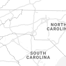
South Carolina
| Local Time | Report Details |
|---|---|
| 2:52 PM EDT | Sc highway patrol reports a tree down near intersection of highway 107 and highway 2 in oconee county SC, 30.1 miles W of Greenville, SC |
| 3:53 PM EDT | Sc highway patrol reports tree down near intersection of talley road and highway 41 in greenville county SC, 16.5 miles NNE of Greenville, SC |
| 4:00 PM EDT | A picture of a tree blown down by thunderstorm outflow winds was relayed by local broadcast media. the tree was down at a home on garris avenu in colleton county SC, 50.7 miles WSW of Charleston, SC |
| 4:05 PM EDT | Tree down along highway 414 near meadow fork r in greenville county SC, 20.1 miles NE of Greenville, SC |
| 4:11 PM EDT | Schp reported a tree down at n tigerville rd and highway 11 in greenville county SC, 22.9 miles NNE of Greenville, SC |
| 4:13 PM EDT | Schp reported a tree down at 385 w mcelhaney rd in greenville county SC, 19.6 miles ENE of Greenville, SC |
| 4:13 PM EDT | Tree and utility lines downed near fowler rd and highway 10 in greenville county SC, 22.8 miles NE of Greenville, SC |
| 4:18 PM EDT | Schp reported a tree down at fews chapel rd and hwy 14 in greenville county SC, 23.7 miles NE of Greenville, SC |
| 6:51 PM EDT | South carolina highway patrol reported a tree down on hope plantation lane near highway 1 in colleton county SC, 41.5 miles SW of Charleston, SC |
| 7:12 PM EDT | Charleston county 911 reported a tree down on highway 162 near the intersection with highway 174. highway 162 had to be closed for a time due to the tree in the roadway in charleston county SC, 37.7 miles SSW of Charleston, SC |
| 7:30 PM EDT | South carolina highway patrol reported a tree down on davison road just north of highway 1 in charleston county SC, 28.5 miles SSW of Charleston, SC |
| 8:19 PM EDT | South carolina highway patrol reported tree down on cavanaugh road near black creek roa in colleton county SC, 51.9 miles WSW of Charleston, SC |
| 8:39 PM EDT | South carolina highway patrol reported a tree down estates drive near the intersection with lemon roa in colleton county SC, 41.5 miles WSW of Charleston, SC |
| 8:39 PM EDT | South carolina highway patrol reported tree down on 200 block of robert e lee driv in colleton county SC, 42 miles WSW of Charleston, SC |
Connecticut
| Local Time | Report Details |
|---|---|
| 2:55 PM EDT | Tree down on car on sunnyside driv in fairfield county CT, 63.4 miles NE of Brooklyn, NY |
| 3:15 PM EDT | 58 mph wind gust recorded on a personal weather station at a home on branford harbo in new haven county CT, 73.8 miles NE of Brooklyn, NY |
| 4:13 PM EDT | Tree down on wires on grieb trail near the intersection with martin trai in new haven county CT, 74.4 miles WSW of Providence, RI |
| 5:05 PM EDT | Tree down on north benson roa in fairfield county CT, 50 miles NE of Brooklyn, NY |
| 5:05 PM EDT | Numerous reports of trees and wires down around tow in fairfield county CT, 47.9 miles NE of Brooklyn, NY |
| 5:11 PM EDT | Several trees down on judd stree in fairfield county CT, 51.3 miles NE of Brooklyn, NY |
Florida
| Local Time | Report Details |
|---|---|
| 3:00 PM EDT | Lightning struck a palm tree at whisper ridge dr off of sr 16. tree is not on fire. time of event estimated with rada in st. johns county FL, 30.8 miles SSE of Jacksonville, FL |
| 4:00 PM EDT | Fire department reports multiple trees down in eastern levy county around cr 32 in levy county FL, 91.2 miles WNW of Orlando, FL |
Missouri
| Local Time | Report Details |
|---|---|
| 2:19 PM CDT | Caseys gas station plastic sign blown out of its holding. other light objects thrown aroun in schuyler county MO, 44.9 miles W of Kahoka, MO |
| 2:55 PM CDT | Delayed report. several trees down in roadways in bible grove per sheriffs offic in scotland county MO, 31 miles W of Kahoka, MO |
| 4:09 PM CDT | Several trees and power lines blown dow in marion county MO, 52.2 miles SSE of Kahoka, MO |
| 4:10 PM CDT | Large tree (12 inch) blown dow in ralls county MO, 59.8 miles SSE of Kahoka, MO |
| 4:55 PM CDT | 3 inch diameter tree limbs snapped and power lines blown down... estimated 60 mph wind gust in lincoln county MO, 49.1 miles NW of Saint Louis, MO |
| 5:35 PM CDT | Large tree down in st. charles on 6th street. time estimated from rada in st. charles county MO, 18.8 miles NW of Saint Louis, MO |
| 5:41 PM CDT | Large limbs down on highway 51. time estimate in bollinger county MO, 25.3 miles W of Cape Girardeau, MO |
| 5:48 PM CDT | Large limb dow in st. charles county MO, 24.5 miles WNW of Saint Louis, MO |
| 5:50 PM CDT | Medium tree uprooted. time estimated from rada in jefferson county MO, 20.6 miles SSW of Saint Louis, MO |
| 6:00 PM CDT | Wires dow in st. louis city county MO, 5.7 miles NNW of Saint Louis, MO |
| 6:01 PM CDT | Large tree dow in st. louis city county MO, 4.6 miles WNW of Saint Louis, MO |
| 6:08 PM CDT | Trees down across the town of pacifi in franklin county MO, 31 miles WSW of Saint Louis, MO |
| 6:25 PM CDT | Large tree and wires down. time estimated from rada in jefferson county MO, 32.4 miles SW of Saint Louis, MO |
| 6:37 PM CDT | Four inch diameter tree snapped at the intersection of us 61 and y highwa in cape girardeau county MO, 9.4 miles NW of Cape Girardeau, MO |
| 7:00 PM CDT | Large limbs down. time estimated from rada in osage county MO, 42.1 miles SE of Columbia, MO |
New York
| Local Time | Report Details |
|---|---|
| 3:20 PM EDT | Tree down near the trinity luther church in rensselaer county NY, 21.8 miles SSE of Schenectady, NY |
| 3:25 PM EDT | Route 203 closed in the town of nassau between evelyn drive and smith road due to downed poles and wire in rensselaer county NY, 27.6 miles SE of Schenectady, NY |
| 3:37 PM EDT | Trees down and snapped on colane roa in columbia county NY, 36.2 miles SE of Schenectady, NY |
| 3:38 PM EDT | Trees down and snapped on bristol roa in columbia county NY, 36.5 miles SE of Schenectady, NY |
| 3:40 PM EDT | Trees on wire in columbia county NY, 38.2 miles SE of Schenectady, NY |
| 3:48 PM EDT | Trees dow in columbia county NY, 36.5 miles SE of Schenectady, NY |
| 8:09 PM EDT | *** 1 inj *** a tree limb fell on a car on west 46th street at 8th avenue. one person was taken to the hospital with injurie in new york (manhatta county NY, 4.7 miles N of Brooklyn, NY |
| 8:15 PM EDT | Large tree down on steinway stree in queens county NY, 7.4 miles NE of Brooklyn, NY |
| 8:30 PM EDT | Several trees down across the area... including central ave at tuckahoe rd... amackassin terrace at eastview ave... 1020 warburton ave... and 331 somerville place in westchester county NY, 18.9 miles NNE of Brooklyn, NY |
| 8:33 PM EDT | Trees and wires down on duck pond roa in nassau county NY, 24.3 miles ENE of Brooklyn, NY |
| 8:41 PM EDT | Oyster bay branch long island railroad service was suspended between locust valley and oyster bay due to downed trees across the tracks east of locust valle in nassau county NY, 24.7 miles ENE of Brooklyn, NY |
North Carolina
| Local Time | Report Details |
|---|---|
| 3:33 PM EDT | Tree down on house. time estimated by rada in harnett county NC, 35.6 miles SW of Raleigh, NC |
| 5:31 PM EDT | Suspected downburst winds downed numerous trees along cleveland road... with at least six impacting structures along hazelnut lane...brazil nut lane...and lee trace dri in johnston county NC, 20.4 miles SE of Raleigh, NC |
| 7:48 PM EDT | Trees down on powerlines on smith r in greene county NC, 53.1 miles ESE of Raleigh, NC |
| 11:55 PM EDT | Trees were reported down on power lines near the intersection of twin acres road and knights bridge d in johnston county NC, 15.5 miles SE of Raleigh, NC |
| 12:00 AM EDT | Trees were reported down on power lines along wilsons mills roa in johnston county NC, 22.2 miles SE of Raleigh, NC |
Georgia
| Local Time | Report Details |
|---|---|
| 4:04 PM EDT | Powerlines reported down along pro dr nw of norcross g in gwinnett county GA, 17.9 miles NNE of Atlanta, GA |
| 4:25 PM EDT | Pine tree reported down near the intersection of lawrenceville hwy and bethesda church r in gwinnett county GA, 21.5 miles ENE of Atlanta, GA |
| 4:30 PM EDT | Two trees were down were reported down along newcastly way sw of snellville g in gwinnett county GA, 20.8 miles ENE of Atlanta, GA |
| 4:35 PM EDT | A tree fell on a powerline near the intersection of shadow lake dr sw and diamond bliff sw in liburn g in gwinnett county GA, 19.4 miles ENE of Atlanta, GA |
| 4:36 PM EDT | Trees reported down along turk rd wsw of bethleham g in barrow county GA, 38.9 miles ENE of Atlanta, GA |
| 4:36 PM EDT | A tree was reported down near the intersection of lays dr and broad st ne of winder g in barrow county GA, 43.4 miles ENE of Atlanta, GA |
| 4:42 PM EDT | Trees were reported down near the intersection of smith chapel rd and manning gin rd se of bethleham g in barrow county GA, 44.1 miles ENE of Atlanta, GA |
| 4:54 PM EDT | A tree was reported down on the 1400 block of georgia club dr... s of statha in barrow county GA, 47.4 miles ENE of Atlanta, GA |
| 5:00 PM EDT | Trees reported down along highway 53 sw of bogart g in oconee county GA, 47.8 miles ENE of Atlanta, GA |
| 5:42 PM EDT | A tree was reported near the intersection of hwy 29 on mama b drive in danielsville g in madison county GA, 59.9 miles SW of Greenville, SC |
Illinois
| Local Time | Report Details |
|---|---|
| 3:05 PM CDT | 2-inch trees down in several spots nearb in hancock county IL, 20.7 miles E of Kahoka, MO |
| 3:45 PM CDT | Large tree snapped and fell onto a garag in adams county IL, 37.5 miles SSE of Kahoka, MO |
| 4:12 PM CDT | Corrects previous tstm wnd dmg report from 3 nnw perry. minor roof damage to a house. time estimated from rada in pike county IL, 64.8 miles SE of Kahoka, MO |
| 4:14 PM CDT | Barn roof destroyed. windows blown out of a tractor. shingles ripped off a roof. time estimated from rada in pike county IL, 68.2 miles SE of Kahoka, MO |
| 4:19 PM CDT | Few downed limb in brown county IL, 58.8 miles ESE of Kahoka, MO |
| 4:20 PM CDT | Storm damage reported in mcdonough county IL, 55.4 miles E of Kahoka, MO |
| 4:25 PM CDT | Trees down... estimated 60-70 mph wind gust in pike county IL, 73.9 miles SE of Kahoka, MO |
| 4:32 PM CDT | Quarter sized hail reported near , , 64.7 miles SW of Peoria, IL |
| 4:34 PM CDT | Tree down north of town near 41 and the railroad track in mcdonough county IL, 48.2 miles W of Peoria, IL |
| 6:10 PM CDT | Tree limbs blown down. shingles blown of several home in st. clair county IL, 9.2 miles E of Saint Louis, MO |
| 6:12 PM CDT | Minor roof damage to a house. time estimated from rada in pike county IL, 64.8 miles SE of Kahoka, MO |
| 6:40 PM CDT | Power lines down along south market street in waterloo. time estimated from rada in monroe county IL, 20.7 miles S of Saint Louis, MO |
| 7:55 PM CDT | Tree limbs down on cars and power line damage. time estimate in jefferson county IL, 75 miles ESE of Saint Louis, MO |
| 8:04 PM CDT | Numerous reports of tree limbs down and damage to power lines across jefferson count in jefferson county IL, 73.6 miles ESE of Saint Louis, MO |
| 8:29 PM CDT | Several trees down along highway 242 at county road 1650 north. time estimate in hamilton county IL, 54.5 miles WNW of Evansville, IN |
Rhode Island
| Local Time | Report Details |
|---|---|
| 4:41 PM EDT | Tree and wires down blocking sherman farm road... trees and wires down on roosevelt ave in providence county RI, 18.1 miles WNW of Providence, RI |
Maryland
| Local Time | Report Details |
|---|---|
| 4:48 PM EDT | Tree down at residence in montgomery county MD, 42.7 miles W of Baltimore, MD |
| 4:56 PM EDT | Multiple wires down on germantown rd. in germantown in montgomery county MD, 37.1 miles WSW of Baltimore, MD |
| 5:00 PM EDT | Tree down on the road in montgomery county MD, 39.8 miles W of Baltimore, MD |
| 5:09 PM EDT | Tree and wires down blocking road in montgomery county MD, 39.3 miles WSW of Baltimore, MD |
| 5:14 PM EDT | Tree down near the 13600 russett r in montgomery county MD, 30.1 miles WSW of Baltimore, MD |
| 5:14 PM EDT | Tree down on study r in carroll county MD, 34.7 miles NW of Baltimore, MD |
| 5:15 PM EDT | Multiple trees down in the area between poolesville... dickerson... and beallsvill in montgomery county MD, 42.1 miles WSW of Baltimore, MD |
| 5:18 PM EDT | Tree down across the road in montgomery county MD, 25.7 miles W of Baltimore, MD |
| 5:18 PM EDT | Tree down onto wires in montgomery county MD, 33.1 miles W of Baltimore, MD |
| 5:19 PM EDT | Multiple trees down in the nanjemoy area... especially near the intersection of sandy point rd. and jacksontown r in charles county MD, 64.6 miles SSW of Baltimore, MD |
| 5:23 PM EDT | Large tree down across the road in montgomery county MD, 25 miles W of Baltimore, MD |
| 5:28 PM EDT | A couple of trees down near sykesville in carroll county MD, 20.1 miles WNW of Baltimore, MD |
| 5:28 PM EDT | Multiple trees down near the intersection of s. tannery rd. and gorsech r in carroll county MD, 25.2 miles NW of Baltimore, MD |
| 5:32 PM EDT | Tree down on poplar ave. between 4th ave. and new hampshire av in montgomery county MD, 30.5 miles SW of Baltimore, MD |
| 5:32 PM EDT | Multiple trees down along liberty rd. east of eldersburg in carroll county MD, 18.7 miles WNW of Baltimore, MD |
| 5:37 PM EDT | *** 1 inj *** tree branch fell on a person. person taken to a hospita in montgomery county MD, 34.8 miles SW of Baltimore, MD |
| 5:37 PM EDT | Tree on a house in montgomery county MD, 36.1 miles SW of Baltimore, MD |
| 5:45 PM EDT | Roof and siding blown off of an apartment complex on garrison view r in baltimore county MD, 11.9 miles NW of Baltimore, MD |
| 5:45 PM EDT | Roof and siding blown off of an apartment complex on garrison view r in baltimore county MD, 10.7 miles NW of Baltimore, MD |
| 5:46 PM EDT | Several trees down in forest hill in harford county MD, 22.4 miles NNE of Baltimore, MD |
| 9:46 PM UTC | Tree down on steed roa in prince georges county MD, 40.7 miles SSW of Baltimore, MD |
| 5:46 PM EDT | Tree down at east-west highway and rosemary hills d in montgomery county MD, 30.6 miles SW of Baltimore, MD |
| 5:46 PM EDT | Tree down blocking two lanes of md-41 in montgomery county MD, 34.4 miles WSW of Baltimore, MD |
| 5:46 PM EDT | Tree down on a car between new hampshire ave and 4th av in montgomery county MD, 30.5 miles SW of Baltimore, MD |
| 6:00 PM EDT | Large trees down on tintern cour in baltimore county MD, 12 miles NNW of Baltimore, MD |
| 6:00 PM EDT | Multiple trees down near the intersection of greenspring ave. and kelly ave. in luthervill in baltimore city county MD, 6.4 miles NNW of Baltimore, MD |
| 6:00 PM EDT | Large tree down blocking three lanes of inner loop 695/baltimore beltway at greensprin in baltimore county MD, 8.3 miles WNW of Baltimore, MD |
| 6:02 PM EDT | Multiple reports of trees down... some on power lines... in lothian in anne arundel county MD, 31.8 miles S of Baltimore, MD |
| 6:07 PM EDT | Tree down near the intersection of east cold spring lane and marble hall roa in baltimore city county MD, 3.4 miles N of Baltimore, MD |
| 6:09 PM EDT | Multiple reports of trees down... some on power lines... in edgewater in anne arundel county MD, 24.3 miles S of Baltimore, MD |
| 6:09 PM EDT | Tree down across roadway... about 18" in diameter in harford county MD, 17.7 miles NNE of Baltimore, MD |
| 6:09 PM EDT | Tree down at the 5400 block of muddy creek r in anne arundel county MD, 33.3 miles S of Baltimore, MD |
| 6:09 PM EDT | Large tree downed... approximately 40 inches in diameter and 78 feet tal in baltimore county MD, 16.9 miles NNE of Baltimore, MD |
| 6:14 PM EDT | Several trees down in the forest hill are in harford county MD, 22.4 miles NNE of Baltimore, MD |
| 6:14 PM EDT | Multiple reports of trees down in narrettsville in harford county MD, 22.4 miles NNE of Baltimore, MD |
| 6:19 PM EDT | Tree down onto residence on saddleback way in harford county MD, 24.1 miles NE of Baltimore, MD |
| 6:20 PM EDT | Numerous (up to four dozen) reports of trees and wires down in the dundalk/essex/middle river area east of baltimore cit in baltimore county MD, 8.6 miles E of Baltimore, MD |
| 6:22 PM EDT | Tree down on wire at the intersection of state route 136 and trappe r in harford county MD, 29.4 miles NE of Baltimore, MD |
| 6:30 PM EDT | Tree down at the intersection of flintville rd. and broad creek r in harford county MD, 33.7 miles NE of Baltimore, MD |
| 6:31 PM EDT | Tree down at the intersection of flintville rd. and broad creek r in harford county MD, 33.7 miles NE of Baltimore, MD |
| 6:35 PM EDT | Multiple trees and powerlines down in the aberdeen are in harford county MD, 27.6 miles ENE of Baltimore, MD |
| 7:00 PM EDT | Numerous trees down in rising sun. time estimated from rada in cecil county MD, 40.8 miles NE of Baltimore, MD |
| 7:00 PM EDT | Tree down in chestertown. time estimated from rada in kent county MD, 29.5 miles E of Baltimore, MD |
| 7:03 PM EDT | Downed utility on md-276 both directions at md-222. road closed. time estimated from rada in cecil county MD, 33.8 miles NE of Baltimore, MD |
| 7:20 PM EDT | Tree down near intersection of routes 291 and 301. time estimated from rada in kent county MD, 40.2 miles E of Baltimore, MD |
| 8:08 PM EDT | Two trees dow in dorchester county MD, 54.2 miles W of Ocean City, MD |
| 8:18 PM EDT | Multiple trees and powerlines down in the aberdeen area in harford county MD, 27.6 miles ENE of Baltimore, MD |
| 8:45 PM EDT | Multiple trees and powerlines down in salisbury... including one tree down on a hous in wicomico county MD, 27.6 miles W of Ocean City, MD |
| 9:15 PM EDT | Trees down on cathell r in worcester county MD, 6.5 miles WNW of Ocean City, MD |
| 10:08 PM EDT | Mesonet station astm2 assateague islan in worcester county MD, 18.7 miles SSW of Ocean City, MD |
Texas
| Local Time | Report Details |
|---|---|
| 4:25 PM CDT | Quarter sized hail reported near Alpine, TX, 0.3 miles WNW of Alpine, TX, estimated hail size from picture on social media. |
| 6:39 PM CDT | Measured on west texas mesonet. also saw 0.8 inches of rain in 20 minute in brewster county TX, 84.5 miles S of Alpine, TX |
District of Columbia
| Local Time | Report Details |
|---|---|
| 5:25 PM EDT | Tree down on power lines at 43rd st. nw and yuma s in district of columb county DC, 34.5 miles SW of Baltimore, MD |
Pennsylvania
| Local Time | Report Details |
|---|---|
| 5:40 PM EDT | Wires down on utz drive in york county PA, 35.7 miles NNW of Baltimore, MD |
| 5:51 PM EDT | Wires down on blooming grove drive in york county PA, 35.5 miles NNW of Baltimore, MD |
| 5:58 PM EDT | Wires down on center street in york county PA, 39.2 miles NNW of Baltimore, MD |
| 6:25 PM EDT | Multiple trees down in and around manor township including at the intersection of river rd and pittsburg hill rd and the intersection of shultz rd and north s in lancaster county PA, 48.7 miles NNE of Baltimore, MD |
| 6:32 PM EDT | Multiple trees down in west lampeter township including at route 222 and east 741 and on beaver valley pike at village r in lancaster county PA, 48.4 miles NNE of Baltimore, MD |
| 6:53 PM EDT | *** 2 inj *** several people knocked down and a couple vehicles flipped at a factory near the intersection of s custer ave and w jackson s in lancaster county PA, 62.3 miles NNE of Baltimore, MD |
| 6:56 PM EDT | Multiple trees down on hess rd in upper leacock townshi in lancaster county PA, 58.5 miles NNE of Baltimore, MD |
| 7:03 PM EDT | Tree down on wires. time estimated from rada in berks county PA, 67.2 miles S of Scranton, PA |
| 7:15 PM EDT | Poles and wires down on birdell rd at gooseberry ln. time estimated from rada in chester county PA, 67 miles NE of Baltimore, MD |
| 7:17 PM EDT | Report of power poles and wires blown down onto cars near timacula rd at route 372. time estimated from rada in chester county PA, 60.1 miles NE of Baltimore, MD |
| 7:20 PM EDT | Poles and wires down on fisherville rd at n bailey rd. time estimated from rada in chester county PA, 67.2 miles NE of Baltimore, MD |
| 7:21 PM EDT | Trees and wires down. time estimated from rada in berks county PA, 79.3 miles NNE of Baltimore, MD |
| 7:27 PM EDT | Tree down and blocking the road on kurtz mill rd at morgantown rd. time estimated from rada in berks county PA, 74.3 miles NNE of Baltimore, MD |
| 7:45 PM EDT | Wires dow in chester county PA, 67.5 miles NE of Baltimore, MD |
| 7:46 PM EDT | Poles and wires down on wollaston rd at w street r in chester county PA, 62.1 miles NE of Baltimore, MD |
| 7:55 PM EDT | Poles and wires down. time estimated from rada in chester county PA, 82.7 miles NE of Baltimore, MD |
| 8:01 PM EDT | Measured gust to 58mp in delaware county PA, 80.6 miles NE of Baltimore, MD |
| 8:41 PM EDT | Downed tree on pa-32. time estimated from rada in bucks county PA, 52.9 miles SW of Brooklyn, NY |
North Dakota
| Local Time | Report Details |
|---|---|
| 4:05 PM MDT | Quarter sized hail reported near Mott, ND, 73.2 miles WSW of Bismarck, ND, hail lasted a few minutes and was mostly pea size. |
| 6:00 PM MDT | Half Dollar sized hail reported near Dickinson, ND, 88.5 miles SSE of Williston, ND, hail lasted a few minutes. time of event uncertain so radar used to estimate it. |
| 6:10 PM MDT | This is about a mile north of i-94 and about a mile east of nd highway 22. also had a lot of pea size hai in stark county ND, 94.3 miles SSE of Williston, ND |
| 7:30 PM CDT | Half Dollar sized hail reported near Newburg, ND, 38 miles NNE of Minot, ND |
| 7:30 PM CDT | Quarter sized hail reported near Fort Yates, ND, 53.1 miles S of Bismarck, ND, hail lasted a few minutes with the largest stones quarter size. spotter said social media video on the storm was posted. |
| 7:30 PM CDT | Half Dollar sized hail reported near Newburg, ND, 37.8 miles NNE of Minot, ND, hail was piled up 6 inches high. |
| 6:33 PM MDT | Ping Pong Ball sized hail reported near Taylor, ND, 82.3 miles W of Bismarck, ND, nd atmospheric resource board observer report. leaves stripped off of trees. small branches broken in gusty wind - no speed estimate. hail lasted about 5 minutes. |
| 7:35 PM CDT | Half Dollar sized hail reported near Newburg, ND, 38 miles NNE of Minot, ND, time estimated based on radar. |
| 6:38 PM MDT | Half Dollar sized hail reported near Taylor, ND, 78 miles W of Bismarck, ND, straight line winds estimated 70 mph. |
| 8:06 PM CDT | Golf Ball sized hail reported near Bottineau, ND, 54.5 miles NE of Minot, ND, in addition to the golf ball sized hail... winds 60 to 70 mph were also occurring. |
| 9:54 PM CDT | Ping Pong Ball sized hail reported near Saint Anthony, ND, 14.2 miles SSW of Bismarck, ND |
| 9:54 PM CDT | Ping Pong Ball sized hail reported near Saint Anthony, ND, 14.7 miles SSW of Bismarck, ND |
Wyoming
| Local Time | Report Details |
|---|---|
| 4:34 PM MDT | Hen Egg sized hail reported near Gillette, WY, 10.4 miles NNW of Gillette, WY |
| 4:56 PM MDT | Quarter sized hail reported near Rozet, WY, 19.2 miles NE of Gillette, WY, mostly pea size but a few quarter size hail. |
| 4:56 PM MDT | Golf Ball sized hail reported near Gillette, WY, 1.2 miles NNE of Gillette, WY |
| 5:02 PM MDT | Ping Pong Ball sized hail reported near Gillette, WY, 0.9 miles SSE of Gillette, WY |
| 5:10 PM MDT | Hen Egg sized hail reported near Gillette, WY, 3.5 miles SSE of Gillette, WY |
| 5:15 PM MDT | Golf Ball sized hail reported near Gillette, WY, 1.5 miles SE of Gillette, WY |
| 5:15 PM MDT | Hen Egg sized hail reported near Gillette, WY, 0.3 miles SE of Gillette, WY |
| 5:20 PM MDT | Golf Ball sized hail reported near Lance Creek, WY, 88.2 miles SSE of Gillette, WY, duration 10 minutes. window damaged. |
| 5:23 PM MDT | Quarter sized hail reported near Lance Creek, WY, 92.1 miles E of Casper, WY |
| 5:28 PM MDT | Golf Ball sized hail reported near Gillette, WY, 5.7 miles SE of Gillette, WY |
| 5:59 PM MDT | Tennis Ball sized hail reported near Beulah, WY, 51.1 miles NW of Rapid City, SD |
| 6:53 PM MDT | Quarter sized hail reported near Four Corners, WY, 44.8 miles W of Rapid City, SD |
New Jersey
| Local Time | Report Details |
|---|---|
| 6:50 PM EDT | Tree down in hampton twp. time estimated from rada in sussex county NJ, 49.5 miles NW of Brooklyn, NY |
| 6:55 PM EDT | Tree limbs down at the fairway valley golf clu in warren county NJ, 53.3 miles W of Brooklyn, NY |
| 7:05 PM EDT | Tree down on n shore rd. time estimated from rada in sussex county NJ, 43.6 miles WNW of Brooklyn, NY |
| 7:45 PM EDT | Tree down blocking ackerman avenue near the train overpas in bergen county NJ, 20.5 miles NNW of Brooklyn, NY |
| 7:45 PM EDT | Tree down on bellair road and west end avenue... knocking out powe in bergen county NJ, 21.1 miles NNW of Brooklyn, NY |
| 7:55 PM EDT | Mping report of 3 inch tree limbs or power poles broke in gloucester county NJ, 80.6 miles ENE of Baltimore, MD |
| 7:56 PM EDT | Downed tree closing 1 or 2 lanes of us-130 northbound at nj-44. time estimated from rada in gloucester county NJ, 76.9 miles ENE of Baltimore, MD |
| 8:00 PM EDT | Several reports of wires down across the county. time estimate in anz430 county NJ, 66.8 miles N of Ocean City, MD |
| 8:00 PM EDT | Large tree down on center avenue north of lake stree in bergen county NJ, 21.3 miles N of Brooklyn, NY |
| 8:09 PM EDT | Mping report of 3 inch tree limbs or power poles broke in gloucester county NJ, 82 miles ENE of Baltimore, MD |
| 8:11 PM EDT | Downed tree on nj-42 southbound exit ramp to college dr. ramp closed. time estimated from rada in gloucester county NJ, 84.3 miles SW of Brooklyn, NY |
| 8:16 PM EDT | Tree down on a car on haddon ave at zane ave. time estimated from rada in camden county NJ, 78.4 miles SW of Brooklyn, NY |
| 8:25 PM EDT | Tree down on a car on schraalenburgh road between demarest avenue and union stree in bergen county NJ, 19.2 miles N of Brooklyn, NY |
| 8:25 PM EDT | Several very large tree branches down in willingbor in burlington county NJ, 66 miles SW of Brooklyn, NY |
| 8:40 PM EDT | Tree down and blocking a lane of nj-31 northbound near cr-636. time estimated from rada in mercer county NJ, 50.4 miles SW of Brooklyn, NY |
| 8:50 PM EDT | Tree down and blocking all lanes of nj-27 southbound south of cr-605. time estimated from rada in mercer county NJ, 39.9 miles SW of Brooklyn, NY |
| 8:55 PM EDT | Downed tree blocking a lane on us-1 northbound at raymond rd. time estimated from rada in middlesex county NJ, 37.8 miles SW of Brooklyn, NY |
| 9:22 PM EDT | Several trees and power lines down in freehold. time estimated from rada in monmouth county NJ, 35 miles SSW of Brooklyn, NY |
| 9:43 PM EDT | Trees and wires down in oceanport. time estimated from rada in monmouth county NJ, 25.7 miles S of Brooklyn, NY |
Minnesota
| Local Time | Report Details |
|---|---|
| 6:20 PM CDT | Mndot road weather station station mn026 brichdale mn-11 mile post 15 in koochiching county MN, 30.6 miles W of International Falls, MN |
| 6:49 PM CDT | Bleachers damaged at fairgrounds in littlefork. tree down on a powerline in littlefork. time estimated by rada in koochiching county MN, 15.9 miles SSW of International Falls, MN |
| 6:49 PM CDT | Trees down along highway 65 near littlefork and trees down knocking down powerlines in littlefork. time estimated by rada in koochiching county MN, 16.3 miles SSW of International Falls, MN |
| 7:45 PM CDT | 5 pine and popple trees that were about 2 feet in diameter knocked down due to straight line wind in koochiching county MN, 45.9 miles SSE of International Falls, MN |
| 4:25 AM CDT | Golf Ball sized hail reported near Prior Lake, MN, 20.9 miles SSW of Minneapolis, MN |
| 4:30 AM CDT | Half Dollar sized hail reported near Savage, MN, 15.8 miles SSW of Minneapolis, MN |
| 4:35 AM CDT | Hen Egg sized hail reported near Burnsville, MN, 15.2 miles S of Minneapolis, MN, reported via twitter with pictures. |
Arizona
| Local Time | Report Details |
|---|---|
| 4:30 PM MST | Corrects previous tstm wnd dmg report from 1 ssw nogales. multiple trees down near intersection of western ave and n bautista s in santa cruz county AZ, 60.1 miles S of Tucson, AZ |
| 5:56 PM MST | Multiple trees down near intersection of western ave and n bautista s in santa cruz county AZ, 60.1 miles S of Tucson, AZ |
Delaware
| Local Time | Report Details |
|---|---|
| 7:40 PM EDT | Several reports of trees and wires down near wyoming and camden. time estimated from rada in kent county DE, 57.5 miles ESE of Baltimore, MD |
| 7:44 PM EDT | Trees and wires down in south dover. time estimated from rada in kent county DE, 59.3 miles E of Baltimore, MD |
| 8:55 PM EDT | Numerous trees down in a long corridor between georgetown and lewes. radar indicated strong downburst or microburst signature. time estimated from rada in sussex county DE, 30 miles NNW of Ocean City, MD |
South Dakota
| Local Time | Report Details |
|---|---|
| 6:00 PM MDT | Half Dollar sized hail reported near Spearfish, SD, 49.5 miles NW of Rapid City, SD |
| 6:15 PM MDT | Tea Cup sized hail reported near Spearfish, SD, 49.5 miles NW of Rapid City, SD |
| 7:17 PM CDT | Quarter sized hail reported near Mc Intosh, SD, 58.7 miles SSW of Bismarck, ND, quarter sized hail from severe thunderstorm. |
| 6:30 PM MDT | Quarter sized hail reported near Spearfish, SD, 39.8 miles NW of Rapid City, SD |
| 7:00 PM MDT | Storm damage reported in meade county SD, 25.7 miles NNW of Rapid City, SD |
| 7:02 PM MDT | Quarter sized hail reported near Sturgis, SD, 21.8 miles NNW of Rapid City, SD, 40-50 mph winds and heavy rain |
| 7:10 PM MDT | Tennis Ball sized hail reported near Piedmont, SD, 18.1 miles NNW of Rapid City, SD |
| 8:10 PM MDT | Storm damage reported in meade county SD, 55.3 miles NE of Rapid City, SD |
| 11:01 PM CDT | Storm damage reported in hughes county SD, 3.1 miles ENE of Pierre, SD |
| 11:23 PM CDT | Corrects previous lsr for time of observatio in walworth county SD, 65.2 miles NNE of Pierre, SD |
| 11:38 PM CDT | Storm damage reported in walworth county SD, 65.2 miles NNE of Pierre, SD |
West Virginia
| Local Time | Report Details |
|---|---|
| 9:00 PM EDT | Tree fell on a fence by oes trailer in ritchie county WV, 65.3 miles WNW of Elkins, WV |
| 10:46 PM EDT | Tree down one half mile up stone valley roa in doddridge county WV, 61.1 miles WNW of Elkins, WV |
Kentucky
| Local Time | Report Details |
|---|---|
| 8:28 PM CDT | Tree down and large limbs down near old mayfield road and hopewell roa in graves county KY, 55.2 miles N of Mc Kenzie, TN |
| 8:52 PM CDT | Tree and limbs down on slickback road. time estimate in marshall county KY, 48.7 miles N of Mc Kenzie, TN |
Nebraska
| Local Time | Report Details |
|---|---|
| 7:35 PM MDT | Quarter sized hail reported near Chadron, NE, 65.9 miles NNE of Scottsbluff, NE |
| 7:40 PM MDT | Half Dollar sized hail reported near Chadron, NE, 65.9 miles NNE of Scottsbluff, NE, nickel to half dollar size hail. |
Connect with Interactive Hail Maps