

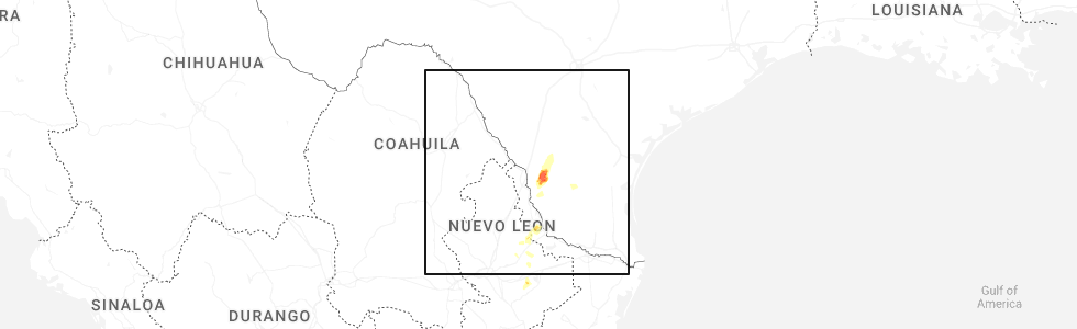
Hail Map for Tuesday, November 25, 2025
Number of Impacted Households on 11/25/2025
0
Impacted by 1" or Larger Hail
0
Impacted by 1.75" or Larger Hail
0
Impacted by 2.5" or Larger Hail
Square Miles of Populated Area Impacted on 11/25/2025
0
Impacted by 1" or Larger Hail
0
Impacted by 1.75" or Larger Hail
0
Impacted by 2.5" or Larger Hail

Cities Most Affected by Hail Storms of 11/25/2025
| Hail Size | Demographics of Zip Codes Affected | ||||||
|---|---|---|---|---|---|---|---|
| City | Count | Average | Largest | Pop Density | House Value | Income | Age |
Hail and Wind Damage Spotted on 11/25/2025
Filter by Report Type:Hail ReportsWind Reports
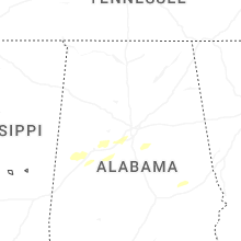
Alabama
| Local Time | Report Details |
|---|---|
| 6:00 AM CST | Tree down on a powerline in centr in cherokee county AL, 65.6 miles SSW of Chattanooga, TN |
| 2:10 PM CST | Quarter sized hail reported near Notasulga, AL, 18.6 miles W of Auburn, AL, quarter size hail reported at reeltown baptist church. time estimated from radar. |
| 2:10 PM CST | Damage reported near stillwaters highway and lovelady road. sliding blown off a structure and hail damage to roof tops. time estimated from rada in tallapoosa county AL, 18.6 miles W of Auburn, AL |
| 2:50 PM CST | Reports of several trees down across the vestavia area. time estimated from rada in jefferson county AL, 6.2 miles S of Birmingham, AL |
Georgia
| Local Time | Report Details |
|---|---|
| 7:25 AM EST | Tree down along fish creek rd per e in polk county GA, 48.6 miles WNW of Atlanta, GA |
| 7:40 AM EST | Tree down near the intersection of bethlehem rd and old cedartown r in polk county GA, 46.4 miles WNW of Atlanta, GA |
| 7:45 AM EST | A vehicle crashed into a downed tree on iron hill road near taylorsville. no injuries reporte in bartow county GA, 42.6 miles NW of Atlanta, GA |
| 8:30 AM EST | A tree was downed on kimball bridge road at tuxford driv in fulton county GA, 22.3 miles NNE of Atlanta, GA |
Nebraska
| Local Time | Report Details |
|---|---|
| 8:49 AM MST | Storm damage reported in cherry county NE, 32.1 miles WSW of Valentine, NE |
Connect with Interactive Hail Maps