

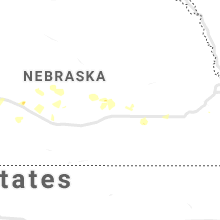
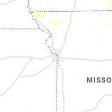
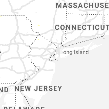
Hail Map for Saturday, July 20, 2019

Number of Impacted Households on 7/20/2019
0
Impacted by 1" or Larger Hail
0
Impacted by 1.75" or Larger Hail
0
Impacted by 2.5" or Larger Hail
Square Miles of Populated Area Impacted on 7/20/2019
0
Impacted by 1" or Larger Hail
0
Impacted by 1.75" or Larger Hail
0
Impacted by 2.5" or Larger Hail


Cities Most Affected by Hail Storms of 7/20/2019
| Hail Size | Demographics of Zip Codes Affected | ||||||
|---|---|---|---|---|---|---|---|
| City | Count | Average | Largest | Pop Density | House Value | Income | Age |
Hail and Wind Damage Spotted on 7/20/2019
Filter by Report Type:Hail ReportsWind Reports
States Impacted
South Dakota, Pennsylvania, Minnesota, Wisconsin, Iowa, North Carolina, Michigan, Illinois, New York, Florida, Colorado, Indiana, New Jersey, Virginia, Ohio, Georgia, Wyoming, Maryland, Kansas, TexasSouth Dakota
| Local Time | Report Details |
|---|---|
| 7:00 AM CDT | Storm damage reported in aurora county SD, 91.8 miles WNW of Sioux Falls, SD |
| 7:14 AM CDT | Sddot rwis sit in hanson county SD, 49.8 miles W of Sioux Falls, SD |
| 7:15 AM CDT | 5-6 inch diameter tree branches down in the tow in aurora county SD, 87.6 miles N of Oneill, NE |
| 7:16 AM CDT | Extensive tree damage in the town. a tree fell onto power lines near the transformer... causing power outages. time estimated from rada in aurora county SD, 78.9 miles N of Oneill, NE |
| 7:19 AM CDT | Measured on home weather statio in lake county SD, 43.2 miles NW of Sioux Falls, SD |
| 7:23 AM CDT | Four boats lifted off their racks along the south shore of lake madison. time estimated from rada in lake county SD, 30.4 miles NNW of Sioux Falls, SD |
| 7:31 AM CDT | Storm damage reported in mccook county SD, 34.1 miles WNW of Sioux Falls, SD |
| 7:32 AM CDT | Heavy damage to grain elevator in town. report relayed via twitter. time estimated from rada in mccook county SD, 28.3 miles W of Sioux Falls, SD |
| 7:33 AM CDT | Awos station kbkx brookings municipal airpor in brookings county SD, 50.9 miles N of Sioux Falls, SD |
| 7:38 AM CDT | Metal roof panels on small apartment building ripped off. time estimated from rada in mccook county SD, 28.3 miles W of Sioux Falls, SD |
| 7:54 AM CDT | Sddot rwis sit in mccook county SD, 22.7 miles WNW of Sioux Falls, SD |
| 7:57 AM CDT | Estimated 60-70 mp in moody county SD, 35.6 miles NNE of Sioux Falls, SD |
| 7:59 AM CDT | Sddot rwis sit in moody county SD, 42.5 miles N of Sioux Falls, SD |
| 7:59 AM CDT | Sddot rwis sit in minnehaha county SD, 19.1 miles N of Sioux Falls, SD |
| 8:07 AM CDT | Asos station kfsd joe foss fiel in minnehaha county SD, 2.6 miles NNW of Sioux Falls, SD |
| 8:10 AM CDT | Peak wind gust recorded at the kmhe aso in davison county SD, 66.9 miles WNW of Sioux Falls, SD |
| 8:16 AM CDT | Asos station kfsd sioux falls airpor in minnehaha county SD, 2.6 miles NNW of Sioux Falls, SD |
| 8:20 AM CDT | Wind split a large maple tre in minnehaha county SD, 3.6 miles E of Sioux Falls, SD |
| 8:35 AM CDT | Maximum wind gust measured at the canton mesonet site... site id k7g in lincoln county SD, 18.2 miles SSE of Sioux Falls, SD |
Pennsylvania
| Local Time | Report Details |
|---|---|
| 8:05 AM EDT | Tree down in pulaski twp in lawrence county PA, 51.8 miles NNW of Pittsburgh, PA |
| 8:06 AM EDT | Power lines down along sr 551 in pulaski tw in lawrence county PA, 49.1 miles NNW of Pittsburgh, PA |
| 8:15 AM EDT | Tree down along glen road in neshannock twp in lawrence county PA, 47.4 miles NNW of Pittsburgh, PA |
| 8:18 AM EDT | Tree down along ashberry lane in neshannock twp in lawrence county PA, 46.1 miles NNW of Pittsburgh, PA |
| 8:18 AM EDT | Tree and wires down in neshannok tw in lawrence county PA, 43.4 miles NNW of Pittsburgh, PA |
| 8:20 AM EDT | Reports of tree and wires down in city of new castle in lawrence county PA, 43 miles NNW of Pittsburgh, PA |
| 8:22 AM EDT | Tree on residence along tony s in lawrence county PA, 41.3 miles NNW of Pittsburgh, PA |
| 8:24 AM EDT | Tree and power lines down in neshannock tw in lawrence county PA, 44.2 miles NNW of Pittsburgh, PA |
| 8:25 AM EDT | Tree down along savannah road in shenango tw in lawrence county PA, 40.4 miles NNW of Pittsburgh, PA |
Minnesota
| Local Time | Report Details |
|---|---|
| 8:12 AM CDT | Pipestone raws station. time estimated from rada in pipestone county MN, 38.1 miles NNE of Sioux Falls, SD |
| 8:30 AM CDT | Asos station kmic crystal a in hennepin county MN, 7.5 miles NNW of Minneapolis, MN |
| 8:30 AM CDT | Large tree... branches down on top of vehicle... roof. pictures on faceboo in hennepin county MN, 5.8 miles NW of Minneapolis, MN |
| 8:35 AM CDT | Mesonet station mn006 beaver creek i-90 mile post in rock county MN, 18.2 miles ENE of Sioux Falls, SD |
| 8:45 AM CDT | 50 foot tree fell on a deck in rural north side of rocheste in olmsted county MN, 63.3 miles WNW of La Crosse, WI |
| 8:57 AM CDT | Asos station krst rochester international airpor in olmsted county MN, 62.6 miles W of La Crosse, WI |
| 8:57 AM CDT | Reports of trees and power lines down in town in wabasha county MN, 52 miles WNW of La Crosse, WI |
| 9:00 AM CDT | Mature oak tree down across 57th ave... snapped off 8ft from bas in goodhue county MN, 36.8 miles SSE of Minneapolis, MN |
| 9:00 AM CDT | Mesonet station mn007 i-90 mile post 3 in nobles county MN, 48.7 miles E of Sioux Falls, SD |
| 9:13 AM CDT | Rwis statio in murray county MN, 61.8 miles S of Montevideo, MN |
| 9:15 AM CDT | Mesonet station mn038 dovray mn-30 mile post 4 in murray county MN, 61.8 miles S of Montevideo, MN |
| 9:30 AM CDT | Lakefield rwis statio in jackson county MN, 68.5 miles N of Storm Lake, IA |
| 9:37 AM CDT | Awos station kmwm windom municipal airpor in cottonwood county MN, 78.8 miles SSE of Montevideo, MN |
| 9:49 AM CDT | Tree branches down in woodbury. gust recorded via home weather statio in washington county MN, 16.9 miles ESE of Minneapolis, MN |
| 9:55 AM CDT | Spotter estimates gusts to around 60mph... power knocked out in st. james are in watonwan county MN, 86 miles SE of Montevideo, MN |
| 10:04 AM CDT | Awos station kfrm fairmont a in martin county MN, 69.9 miles WNW of Mason City, IA |
| 10:15 AM CDT | Pine tree uprooted and large branches dow in watonwan county MN, 85.4 miles SE of Montevideo, MN |
| 10:30 AM CDT | 4 inch diameter branches dow in faribault county MN, 65 miles NW of Mason City, IA |
| 10:38 AM CDT | Multiple trees down across tow in waseca county MN, 63.3 miles SSW of Minneapolis, MN |
| 10:45 AM CDT | Spotter reports large tree branches down in and around waldor in waseca county MN, 59.6 miles NNW of Mason City, IA |
| 10:50 AM CDT | Multiple trees down across tow in waseca county MN, 63.2 miles S of Minneapolis, MN |
| 10:51 AM CDT | 12 to 16 inch diameter limb broken off on southwest corner of county road 45 and 250 st. noted that much of the cornfield visible from 45 was laid over in that area. ab in rice county MN, 52.4 miles S of Minneapolis, MN |
| 11:00 AM CDT | Storm damage reported in washington county MN, 23.9 miles E of Minneapolis, MN |
| 11:00 AM CDT | Medium to large branches down and estimated 50-60mph gust in freeborn county MN, 35.8 miles NNW of Mason City, IA |
| 11:00 AM CDT | Several trees and branches down. pictures via faceboo in freeborn county MN, 42.5 miles N of Mason City, IA |
| 11:00 AM CDT | Large tree snapped at base. time estimate in steele county MN, 50.2 miles N of Mason City, IA |
| 11:00 AM CDT | Large tree branches dow in steele county MN, 62.2 miles S of Minneapolis, MN |
| 11:00 AM CDT | 6 inch branch down... other smaller branches also dow in steele county MN, 55.2 miles S of Minneapolis, MN |
| 11:01 AM CDT | Storm damage reported in freeborn county MN, 35.5 miles N of Mason City, IA |
| 11:05 AM CDT | Widespread tree damage... roof damage to commercial building. time estimated from rada in freeborn county MN, 29.5 miles N of Mason City, IA |
| 11:15 AM CDT | Tree uprooted at owatonna country club. time estimate in steele county MN, 63.1 miles N of Mason City, IA |
| 11:15 AM CDT | Trees down around the fairgrounds... time estimate in freeborn county MN, 36.3 miles NNW of Mason City, IA |
| 11:15 AM CDT | Large tree uprooted and power lines down in east park. time estimated from rada in goodhue county MN, 55.9 miles SSE of Minneapolis, MN |
| 11:16 AM CDT | Several 6 inch branches down across tow in steele county MN, 50.2 miles N of Mason City, IA |
| 11:20 AM CDT | Storm damage reported in dodge county MN, 62.9 miles NNE of Mason City, IA |
| 11:22 AM CDT | Social media photos of trees down. relayed via broadcast medi in mower county MN, 49.2 miles NNE of Mason City, IA |
| 11:24 AM CDT | Numerous trees reported down in town in mower county MN, 38 miles NNE of Mason City, IA |
| 11:24 AM CDT | Large tree down in northwest austin. social media photo relayed by broadcast medi in mower county MN, 38.5 miles NNE of Mason City, IA |
| 11:24 AM CDT | Tree uprooted. relayed via broadcast media. time estimated from rada in olmsted county MN, 67 miles NNE of Mason City, IA |
| 11:30 AM CDT | 2-4 inch branches down. picture on faceboo in goodhue county MN, 50.8 miles SSE of Minneapolis, MN |
| 11:32 AM CDT | Storm damage reported in olmsted county MN, 63.4 miles WNW of La Crosse, WI |
| 11:32 AM CDT | Social media photo of large portion of tree down. relayed via broadcast media. time estimated from rada in olmsted county MN, 64.6 miles WNW of La Crosse, WI |
| 11:34 AM CDT | Storm damage reported in olmsted county MN, 62.7 miles W of La Crosse, WI |
| 11:42 AM CDT | Via personal weather station near century hills. power outage in olmsted county MN, 62 miles WNW of La Crosse, WI |
| 12:12 PM CDT | Report of trees down in winona county MN, 26.1 miles NW of La Crosse, WI |
Wisconsin
| Local Time | Report Details |
|---|---|
| 8:57 AM CDT | Delayed report. multiple trees and branches down in galesville. relayed via social media. time estimated from rada in trempealeau county WI, 19.2 miles NNW of La Crosse, WI |
| 9:00 AM CDT | Delayed report. numerous reports of trees down. time estimated from rada in trempealeau county WI, 17.2 miles N of La Crosse, WI |
| 9:09 AM CDT | Trees reported down in la crosse county WI, 17.8 miles NNE of La Crosse, WI |
| 9:10 AM CDT | Large tree uprooted onto campe in eau claire county WI, 69.2 miles NNW of La Crosse, WI |
| 9:34 AM CDT | Time estimated. trees knocked dow in la crosse county WI, 17.9 miles ENE of La Crosse, WI |
| 9:35 AM CDT | Reports of trees and power lines down in northern part of count in la crosse county WI, 12.1 miles NNE of La Crosse, WI |
| 9:36 AM CDT | Numerous trees down between hatfield and neillsville. time estimated from rada in clark county WI, 50.4 miles NNE of La Crosse, WI |
| 9:47 AM CDT | Shingle damage to buildings on fort along with localized flooding in monroe county WI, 31.9 miles ENE of La Crosse, WI |
| 9:48 AM CDT | Reports of trees down in various parts of county... including some reports of fire in jackson county WI, 42.2 miles NNE of La Crosse, WI |
| 9:49 AM CDT | Damage to area trees and power lines in trempealeau county WI, 36.4 miles N of La Crosse, WI |
| 9:56 AM CDT | Reports of trees down along county road q between angelo and ft mccoy in monroe county WI, 27 miles ENE of La Crosse, WI |
| 9:58 AM CDT | Report of a semi truck blown off highway 1 in clark county WI, 60.9 miles NNE of La Crosse, WI |
| 10:08 AM CDT | Very strong winds. estimated 60 mph or greater. some roof damage and many trees dow in clark county WI, 74 miles SW of Rhinelander, WI |
| 10:11 AM CDT | Storm damage reported in wood county WI, 76.8 miles SSW of Rhinelander, WI |
| 10:11 AM CDT | Trees and power lines down on highway 54 in wood county WI, 78.8 miles ENE of La Crosse, WI |
| 10:12 AM CDT | 1 to 1.5 ft diameter tree down. time estimated from rada in clark county WI, 76.7 miles NE of La Crosse, WI |
| 10:25 AM CDT | Branches down blocking the road on a residential street. branches as big as 5 inches in diameter and 10 feet long. may be larger down the roa in wood county WI, 81.1 miles ENE of La Crosse, WI |
| 10:26 AM CDT | Sporadic down tree in wood county WI, 64.9 miles ENE of La Crosse, WI |
| 10:26 AM CDT | Trees down in wisconsin rapids. one at canal street another at fisher stree in wood county WI, 81.1 miles ENE of La Crosse, WI |
| 10:26 AM CDT | Many trees down at an apartment complex. estimated about 1 foot in diamete in portage county WI, 76.6 miles W of Green Bay, WI |
| 10:29 AM CDT | Measured gusts at coop station plow3. also reported on damage to menards in town and doors blown out of the stor in portage county WI, 75.3 miles W of Green Bay, WI |
| 10:30 AM CDT | Numerous tree limbs down and one tree down. diameter larger than one foo in portage county WI, 71 miles WSW of Green Bay, WI |
| 10:32 AM CDT | Trees and power lines down on highway 54 in wood county WI, 78.8 miles ENE of La Crosse, WI |
| 10:36 AM CDT | Lots of power lines down on fisher road in wood county WI, 81.1 miles ENE of La Crosse, WI |
| 10:38 AM CDT | Reports of trees down in townships of finley and armenia in juneau county WI, 62.6 miles ENE of La Crosse, WI |
| 10:38 AM CDT | Trees down. time estimate in waushara county WI, 75.7 miles WSW of Green Bay, WI |
| 10:38 AM CDT | Trees down. all trees appear to have fallen in the same direction. delayed report. time estimate in portage county WI, 76.6 miles W of Green Bay, WI |
| 10:40 AM CDT | Uprooted trees adn tree damage in trailer park on hayes avenue. siding is off some trailer in portage county WI, 75.3 miles W of Green Bay, WI |
| 10:43 AM CDT | Lake dubay county park. numerous trees down. estimated winds of 70 mp in portage county WI, 68.2 miles SSW of Rhinelander, WI |
| 10:45 AM CDT | Near amherst. trees down about 5 inches in diameter and blowing debri in portage county WI, 62.9 miles W of Green Bay, WI |
| 10:46 AM CDT | Trees down. estimated winds of 90 mp in portage county WI, 70.3 miles W of Green Bay, WI |
| 10:47 AM CDT | Large tree down on interstate 39 southbound lane about 8 miles north of stevens poin in portage county WI, 70 miles S of Rhinelander, WI |
| 10:49 AM CDT | Reports of trees down in adams county WI, 73.7 miles ENE of La Crosse, WI |
| 10:49 AM CDT | Trees down. time estimate in waushara county WI, 65.6 miles WSW of Green Bay, WI |
| 10:57 AM CDT | Update to previous report. roof damage to some buildings. numerous trees dow in portage county WI, 70.3 miles W of Green Bay, WI |
| 11:00 AM CDT | Trees down on homes... roads... wires across the town. time estimated in waupaca county WI, 55.5 miles W of Green Bay, WI |
| 11:01 AM CDT | Storm damage reported in marathon county WI, 48 miles SSW of Rhinelander, WI |
| 11:01 AM CDT | Debris flying across road. estimated 80 mph wind in portage county WI, 62.9 miles W of Green Bay, WI |
| 11:05 AM CDT | Large tree down... about one foot in diamete in waupaca county WI, 54.4 miles W of Green Bay, WI |
| 11:06 AM CDT | Trees down. time estimate in shawano county WI, 58.6 miles SSE of Rhinelander, WI |
| 11:10 AM CDT | Time estimated by radar. numerous trees down within the town. major damage reported. many streets covered with downed trees and limbs. power is ou in waupaca county WI, 37.7 miles WSW of Green Bay, WI |
| 11:15 AM CDT | Trees down on highway 34 and other area in marathon county WI, 65.4 miles SSW of Rhinelander, WI |
| 11:20 AM CDT | A couple of road signs down over 441 southbound. power pole bent over near 41 and ballard. a couple other road signs blown over and tree damage as wel in outagamie county WI, 26 miles SW of Green Bay, WI |
| 11:22 AM CDT | Storm damage reported in outagamie county WI, 26 miles SW of Green Bay, WI |
| 11:23 AM CDT | Trees down. delayed report. time estimate in winnebago county WI, 31.3 miles SW of Green Bay, WI |
| 11:23 AM CDT | 2 trees uprooted and house damag in outagamie county WI, 26 miles SW of Green Bay, WI |
| 11:25 AM CDT | Measured gust at perkins and college avenu in outagamie county WI, 26 miles SW of Green Bay, WI |
| 11:28 AM CDT | Tree limbs down in outagamie county WI, 26 miles SW of Green Bay, WI |
| 11:31 AM CDT | Storm damage reported in calumet county WI, 26.9 miles SSW of Green Bay, WI |
| 11:32 AM CDT | Trees and power lines down all over the place. street flooding in waupaca county WI, 54.4 miles W of Green Bay, WI |
| 11:32 AM CDT | Widespread trees down across the county. time estimate in shawano county WI, 34 miles WNW of Green Bay, WI |
| 11:37 AM CDT | Multiple trees down. delayed report. time estimated by rada in outagamie county WI, 16.6 miles SW of Green Bay, WI |
| 11:43 AM CDT | Trees down. time estimate in shawano county WI, 17.5 miles NW of Green Bay, WI |
| 11:44 AM CDT | Multiple large trees down. located near the middle of the cit in brown county WI, 14.6 miles SSW of Green Bay, WI |
| 11:45 AM CDT | Large tree branches down on garvey ave. time estimated by rada in outagamie county WI, 16.2 miles SW of Green Bay, WI |
| 11:59 AM CDT | Storm damage reported in brown county WI, 0.5 miles ESE of Green Bay, WI |
| 12:00 PM CDT | Damage to retail store in plover. glass doors blown in... pipes fell from ceilin in portage county WI, 75.3 miles W of Green Bay, WI |
| 12:00 PM CDT | Downed trees on county highway q between lorenz and beagle streets. one tree about 13 inches in diameter down on a power line. time estimated by rada in manitowoc county WI, 26.2 miles SE of Green Bay, WI |
| 12:01 PM CDT | Trees down. delayed report. time estimate in brown county WI, 14.9 miles SE of Green Bay, WI |
| 12:01 PM CDT | Numerous trees down across the county. time estimate in manitowoc county WI, 22.9 miles SE of Green Bay, WI |
| 12:05 PM CDT | Six to eight inch oak tree branch down on beech tree and west point road. report via social medi in brown county WI, 0.5 miles ESE of Green Bay, WI |
| 12:05 PM CDT | Trees down on highway q north of manitowoc in manitowoc county WI, 34.6 miles SSE of Green Bay, WI |
| 12:06 PM CDT | Tree down blocking the road. time estimate in manitowoc county WI, 33.5 miles SE of Green Bay, WI |
| 12:09 PM CDT | Tree moved a house off its foundation. delayed report. time estimate in manitowoc county WI, 27.1 miles SE of Green Bay, WI |
| 12:09 PM CDT | Trees down. delayed report. time estimate in kewaunee county WI, 18.1 miles ESE of Green Bay, WI |
| 12:12 PM CDT | Trees down. delayed report. time estimate in kewaunee county WI, 23.3 miles ESE of Green Bay, WI |
| 12:15 PM CDT | Trees and wires down all across wrightstown. time estimate in brown county WI, 14.6 miles SSW of Green Bay, WI |
| 12:15 PM CDT | Large tree dow in sheboygan county WI, 57.6 miles S of Green Bay, WI |
| 12:18 PM CDT | Trees down. time estimate in kewaunee county WI, 25 miles ESE of Green Bay, WI |
| 12:35 PM CDT | Large branches dow in washington county WI, 65.2 miles ENE of Madison, WI |
| 12:39 PM CDT | Trees down across the county. time estimate in door county WI, 30.8 miles ENE of Green Bay, WI |
| 12:54 PM CDT | Photos of trees down. relayed via broadcast medi in la crosse county WI, 17.9 miles ENE of La Crosse, WI |
| 1:10 PM CDT | Tree branches and power lines dow in fond du lac county WI, 60 miles SW of Green Bay, WI |
| 1:25 PM CDT | Trees knocked down. time estimated from rada in richland county WI, 49.2 miles ESE of La Crosse, WI |
| 2:00 PM CDT | Storm damage reported in iowa county WI, 36.6 miles W of Madison, WI |
| 2:07 PM CDT | Damage to grain and fertilizer bins... multiple structures... and a tree uprooted. time estimated by rada in lafayette county WI, 41.4 miles WSW of Madison, WI |
Iowa
| Local Time | Report Details |
|---|---|
| 9:06 AM CDT | Four inch diameter tree branch dow in sioux county IA, 31.7 miles SE of Sioux Falls, SD |
| 9:10 AM CDT | Mesonet station rsyi4 2 ne sible in osceola county IA, 51.9 miles E of Sioux Falls, SD |
| 9:15 AM CDT | Large trees down throughout the tow in sioux county IA, 49.5 miles WNW of Storm Lake, IA |
| 9:30 AM CDT | Six inch diameter tree branches dow in osceola county IA, 48.5 miles NNW of Storm Lake, IA |
| 9:32 AM CDT | Estimated 60 mph wind at scharnberg park. tree limbs breakin in clay county IA, 35 miles N of Storm Lake, IA |
| 9:34 AM CDT | Five inch tree limbs broke in cherokee county IA, 33.4 miles WNW of Storm Lake, IA |
| 9:35 AM CDT | Large tents destroyed by arnolds park amusement park. time estimated from rada in dickinson county IA, 50 miles N of Storm Lake, IA |
| 9:43 AM CDT | Asos station kspw spencer municipal airpor in clay county IA, 36.1 miles N of Storm Lake, IA |
| 9:50 AM CDT | Storm damage reported in clay county IA, 34.6 miles NNE of Storm Lake, IA |
| 10:01 AM CDT | Asos station kest estherville airpor in emmet county IA, 56.8 miles NNE of Storm Lake, IA |
| 10:03 AM CDT | Storm damage reported in emmet county IA, 57.4 miles NNE of Storm Lake, IA |
| 10:37 AM CDT | Estimated 60 mph gust. a few larger tree limbs are down with several smaller branches and twig in kossuth county IA, 45.2 miles ENE of Storm Lake, IA |
| 10:38 AM CDT | Several larger tree limbs down in algon in kossuth county IA, 52.3 miles W of Mason City, IA |
| 10:55 AM CDT | Storm damage reported in hancock county IA, 21.9 miles WNW of Mason City, IA |
| 10:58 AM CDT | Multiple spotters have reported tree limbs... about 3 to 4 inches in diameter have been downe in winnebago county IA, 23.7 miles WNW of Mason City, IA |
| 11:06 AM CDT | Social media picture of 5 inch tree limbs downed. time estimated from rada in hancock county IA, 20.4 miles W of Mason City, IA |
| 11:06 AM CDT | Social media picture of large tree limb... around 10 inches in diameter... broken in garner... i in hancock county IA, 20.9 miles W of Mason City, IA |
| 11:15 AM CDT | Storm damage reported in wright county IA, 39.9 miles SW of Mason City, IA |
| 11:20 AM CDT | Storm damage reported in cerro gordo county IA, 6.6 miles W of Mason City, IA |
| 11:26 AM CDT | Kimt-tv viewer shares photo of large tree limb snapped in mason city. diameter appears to be at least 8 inche in cerro gordo county IA, 0.2 miles NNE of Mason City, IA |
| 11:34 AM CDT | Tree blown dow in mitchell county IA, 29.3 miles NE of Mason City, IA |
| 11:38 AM CDT | Social media picture of downed tree limbs about 2 to 3 inches in diameter... tents ripped apart. wind gusts estimated 50 to 60 mp in franklin county IA, 28.1 miles S of Mason City, IA |
| 11:38 AM CDT | Large tree limb down on franklin county fairgrounds. via social media picture. time estimated by rada in franklin county IA, 28.1 miles S of Mason City, IA |
| 11:49 AM CDT | Photo of tree down on house. relayed via broadcast media. time estimated from rada in floyd county IA, 27.4 miles E of Mason City, IA |
| 12:13 PM CDT | A large tree limb nearly 1 foot in diameter was broken with the gust front. there was no thunderstorm... but the gust front from thunderstorms to the north produced win in bremer county IA, 46.9 miles SE of Mason City, IA |
| 12:13 PM CDT | Kwwl-tv viewer shares pictures of tree damage... branches 2 to 3 inches in diameter downed in waverly. time estimated by rada in bremer county IA, 46.5 miles SE of Mason City, IA |
| 12:58 PM CDT | A few trees down on power lines in clayton county IA, 63.9 miles NNE of Cedar Rapids, IA |
| 1:50 PM CDT | Several 1-2 inch tree branches down near residence... one 4 foot long 2 inch healthy tree branch down. also noted some shingles blown down on shed. time estimated from in dubuque county IA, 64.1 miles NE of Cedar Rapids, IA |
| 4:35 PM CDT | Large tree down just outside of town. passed on from perry pd. time estimate in dallas county IA, 30.8 miles NW of Des Moines, IA |
| 5:00 PM CDT | Report via dallas center fd. pole barn lost roof at feed lot. time estimate in dallas county IA, 18.9 miles WNW of Des Moines, IA |
| 5:00 PM CDT | 4 inch tree limbs down at f31 & r22. time estimate in dallas county IA, 19.2 miles NW of Des Moines, IA |
| 5:02 PM CDT | Large tree down along vine st. time estimate in dallas county IA, 18.4 miles WNW of Des Moines, IA |
| 5:02 PM CDT | Power poles down. relayed via fire department. time estimate in dallas county IA, 13.9 miles NW of Des Moines, IA |
| 5:15 PM CDT | Residential shed tipped over. via social media. time estimate in polk county IA, 14.9 miles NNE of Des Moines, IA |
| 5:15 PM CDT | Polk county emergency management staff reported 4 inch tree branch dow in polk county IA, 9.7 miles N of Des Moines, IA |
| 5:18 PM CDT | Portable message boards blown over. time estimate in polk county IA, 7.2 miles NNE of Des Moines, IA |
| 5:20 PM CDT | Utility wires dow in dallas county IA, 15.8 miles NW of Des Moines, IA |
| 5:23 PM CDT | Corrects previous tstm wnd dmg report (time) from 3 sse ankeny. large 6 to 8 inch tree branch snapped. report via social media. delayed report. time estimated via radar in polk county IA, 8 miles NNE of Des Moines, IA |
| 5:24 PM CDT | Trees down at the ia dot facility in ankeny. small 4 to 6 inch diameter trees snapped and blown down. time estimated from radar... delayed repor in polk county IA, 6.7 miles NNE of Des Moines, IA |
| 5:43 PM CDT | Idot reports tree and power line damage along highway 92. time estimate in warren county IA, 16 miles S of Des Moines, IA |
| 5:50 PM CDT | Estimated 50 to 60 mph wind with a lot of minor tree damage... small branches and leaves down. time estimate in warren county IA, 27.6 miles S of Des Moines, IA |
| 6:10 PM CDT | Knia/krls reported power outages across the county... as well as a tree down at a campground near red rock... possibly trapping someone in a vehicle. via radio news soc in marion county IA, 37.3 miles ESE of Des Moines, IA |
| 6:10 PM CDT | Two 4 inch maple branches down. multiple reports of tree damage across town. time estimate in marion county IA, 32.2 miles ESE of Des Moines, IA |
| 6:10 PM CDT | Time estimated by radar. numerous trees down at property. largest 14 inches in diameter. tree branch left a hole in roof of residenc in guthrie county IA, 41.9 miles WNW of Des Moines, IA |
| 6:15 PM CDT | Awos station kcnc chariton airpor in lucas county IA, 41.3 miles SSE of Des Moines, IA |
| 6:15 PM CDT | Awos station koxv knoxville airpor in marion county IA, 33.5 miles SE of Des Moines, IA |
| 6:21 PM CDT | Guthrie co emergency manager reported large trees down in yale. several streets blocke in guthrie county IA, 40.7 miles WNW of Des Moines, IA |
| 6:40 PM CDT | Mahaska county emergency manager reports many instances of tree damage and power outages countywide. time estimated per center of count in mahaska county IA, 54.7 miles ESE of Des Moines, IA |
| 6:54 PM CDT | Storm damage reported in monroe county IA, 57.4 miles SE of Des Moines, IA |
| 6:55 PM CDT | Power lines down on ia 23 near the intersection of tiller avenue blocking both lanes. they also advised there are possibly sparking power lines near the roadway just ea in mahaska county IA, 63.1 miles ESE of Des Moines, IA |
| 7:00 PM CDT | Large tree down... 20 to 30 foot tall and 6 inch diameter trunk. reported at 142nd and lakeview... cliv in polk county IA, 10.2 miles W of Des Moines, IA |
| 7:00 PM CDT | Asos station kotm ottumwa regional airpor in wapello county IA, 60.5 miles NW of Kahoka, MO |
| 7:00 PM CDT | 60 mph winds with gutter blown off neighbors hous in dallas county IA, 12.8 miles W of Des Moines, IA |
| 7:04 PM CDT | 8 inch tree branch down near warrior ln and hickma in dallas county IA, 13.3 miles W of Des Moines, IA |
| 7:05 PM CDT | 4-5 inch tree branch down on the side of alices rd. this is a delayed repor in dallas county IA, 12.6 miles WNW of Des Moines, IA |
| 7:05 PM CDT | Power poles leaning over halfway to the ground. this is a delayed repor in dallas county IA, 12.8 miles WNW of Des Moines, IA |
| 7:10 PM CDT | Wayne county emergency manager reported power lines down in town. time estimate in wayne county IA, 67.9 miles SSE of Des Moines, IA |
| 7:15 PM CDT | Large 6 to 8 inch tree branch snapped. report via social media. delayed report. time estimated via rada in polk county IA, 8 miles NNE of Des Moines, IA |
| 7:25 PM CDT | Tree uprooted on south side of ottumwa. via social media. time estimated from rada in wapello county IA, 54.3 miles NW of Kahoka, MO |
North Carolina
| Local Time | Report Details |
|---|---|
| 1:15 PM EDT | Trained spotter reported trees down on la foret d in burke county NC, 63 miles NW of Charlotte, NC |
| 1:15 PM EDT | Tree down on normandy dr in morganto in burke county NC, 62.2 miles NW of Charlotte, NC |
| 1:15 PM EDT | Numerous trees down on jamestown rd in burke county NC, 63 miles WNW of Charlotte, NC |
| 1:15 PM EDT | The wind damage in this area was due to a microburst spreading out from the jamestown flea market where the roof was blown off. tree damage was extensive around the fle in burke county NC, 61.4 miles NW of Charlotte, NC |
| 2:12 PM EDT | Trained spotter reported multiple trees down in the eagle mills rd road are in iredell county NC, 54.3 miles N of Charlotte, NC |
| 2:35 PM EDT | Quarter sized hail reported near , , 57.3 miles NW of Charlotte, NC, amateur radio reported quarter sized hail in hudson. |
| 2:35 PM EDT | Quarter sized hail reported near Hudson, NC, 57.1 miles NW of Charlotte, NC, amateur radio reported quarter (1.00') size hail in hudson |
| 2:38 PM EDT | County 911 call center reports roof of mobile home blown down into structure on mount herman road. all residents evacuated safel in caldwell county NC, 57.5 miles NW of Charlotte, NC |
| 3:30 PM EDT | Trees down on powerlines near intersection of highway 15/501 and brown roa in lee county NC, 34.8 miles WSW of Raleigh, NC |
| 3:37 PM EDT | Multiple trees were reported down near the intersection of everette dowdy road and walter bright roa in chatham county NC, 34.1 miles WSW of Raleigh, NC |
Michigan
| Local Time | Report Details |
|---|---|
| 2:35 PM EDT | Trees down on roa in leelanau county MI, 16.4 miles WNW of Traverse City, MI |
| 2:35 PM EDT | Trees across roa in leelanau county MI, 11.8 miles NW of Traverse City, MI |
| 2:52 PM EDT | Tree down blocking m-22 north of suttons ba in leelanau county MI, 15.9 miles N of Traverse City, MI |
| 2:57 PM EDT | Trees reported down via law enforcemen in leelanau county MI, 15.3 miles N of Traverse City, MI |
| 3:17 PM EDT | Trees dow in manistee county MI, 44.7 miles SW of Traverse City, MI |
| 3:30 PM EDT | Multiple trees dow in cheboygan county MI, 58.7 miles WNW of Alpena, MI |
| 4:52 PM EDT | Wires down in richland. time estimated from radar. occurred during thunderstorm outflo in kalamazoo county MI, 41.9 miles SSE of Grand Rapids, MI |
| 5:04 PM EDT | Wires down. time estimated from radar. occurred in thunderstorm outflo in kalamazoo county MI, 53.1 miles S of Grand Rapids, MI |
| 5:09 PM EDT | Asos station kbtl battle cree in calhoun county MI, 50 miles SSE of Grand Rapids, MI |
| 5:33 PM EDT | Large tree limbs down. time estimated by rada in saginaw county MI, 22.2 miles N of Flint, MI |
| 5:33 PM EDT | Large tree limbs dow in saginaw county MI, 22.2 miles N of Flint, MI |
| 5:35 PM EDT | Tree down at mott college baseball fiel in genesee county MI, 1.4 miles NNE of Flint, MI |
| 5:36 PM EDT | Social media pictures of large tree limbs down at kearsley park and chavez roa in genesee county MI, 1.4 miles NNE of Flint, MI |
| 5:37 PM EDT | Shingles blown off roof in crossroads village. report relayed via mpin in genesee county MI, 5.8 miles NNE of Flint, MI |
| 5:40 PM EDT | Large tree uprooted onto house. time estimated via rada in genesee county MI, 13.8 miles NE of Flint, MI |
| 5:41 PM EDT | Trees down throughout town... siding torn off buildings downtown... window blown out of buildin in shiawassee county MI, 16.2 miles WNW of Flint, MI |
| 5:45 PM EDT | Window blown in at courtland mall in burton. time estimated via rada in genesee county MI, 2.9 miles ENE of Flint, MI |
| 5:45 PM EDT | Trees down at the intersection of lapeer and genesee roads. time estimated by rada in genesee county MI, 3.9 miles E of Flint, MI |
| 5:51 PM EDT | West-facing closed garage door partly blown in. small trees dow in lapeer county MI, 17.8 miles NE of Flint, MI |
| 5:55 PM EDT | Station number mi-lp-9 in lapeer county MI, 22.3 miles NE of Flint, MI |
| 5:58 PM EDT | Social media pictures of large tree limbs down at lapeer and genesse road in lapeer county MI, 18.7 miles E of Flint, MI |
| 5:58 PM EDT | Large tree limbs down in downtown lapeer in lapeer county MI, 18.7 miles E of Flint, MI |
| 6:13 PM EDT | Trees down throughout the are in livingston county MI, 19.7 miles S of Flint, MI |
| 6:23 PM EDT | Many trees... including large ones... are down around across applegate in sanilac county MI, 56.9 miles ENE of Flint, MI |
| 6:23 PM EDT | Social media pictures of corn nearly flattened and small-to-medium sized tree branches dow in sanilac county MI, 45.2 miles ENE of Flint, MI |
| 6:24 PM EDT | Trees down. time estimated by rada in lapeer county MI, 29.4 miles ENE of Flint, MI |
| 6:25 PM EDT | Construction speed limit signs snapped and blown down in oakland county MI, 31.2 miles SE of Flint, MI |
| 6:30 PM EDT | Pictures of a tree down on a hous in sanilac county MI, 57 miles ENE of Flint, MI |
| 6:52 PM EDT | Social media pictures of tree down at curry rd and 11 mil in oakland county MI, 45.4 miles SE of Flint, MI |
| 6:55 PM EDT | Large downed trees and branches. time estimated by rada in wayne county MI, 52.5 miles SE of Flint, MI |
| 7:02 PM EDT | A thunderstorm wind gust... 54 knots... 62 mph... was measured at selfridge air national guard bas in macomb county MI, 51.1 miles ESE of Flint, MI |
| 7:04 PM EDT | Measured at peche island ligh in lcz460 county MI, 59.8 miles SE of Flint, MI |
| 7:05 PM EDT | Social media pictures of large tree limbs dow in wayne county MI, 59.7 miles SSE of Flint, MI |
Illinois
| Local Time | Report Details |
|---|---|
| 3:30 PM CDT | Multiple tree limbs... some large... blown down. relayed via social medi in winnebago county IL, 57 miles SSE of Madison, WI |
| 3:34 PM CDT | Corrects previous tstm wnd dmg report from loves park. small branches down. in addition... images shared show a few larger tree limbs dow in winnebago county IL, 55.2 miles SSE of Madison, WI |
| 3:45 PM CDT | 5-inch diameter and 30 foot long tree branch down. time estimated via rada in winnebago county IL, 56.9 miles SSE of Madison, WI |
| 3:47 PM CDT | Large tree approximately two feet in diameter snapped near the base. tree appeared at least somewhat rotte in winnebago county IL, 60.1 miles SSE of Madison, WI |
| 4:00 PM CDT | Trees down. time estimated via rada in mchenry county IL, 56.3 miles WNW of Chicago, IL |
| 4:05 PM CDT | Trees down. time estimated via rada in mchenry county IL, 45.9 miles NW of Chicago, IL |
| 4:10 PM CDT | Large tree down blocking derby line rd. relayed via social media. time estimated via rada in de kalb county IL, 55.6 miles WNW of Chicago, IL |
| 4:17 PM CDT | Large tree downe in mchenry county IL, 42.6 miles WNW of Chicago, IL |
| 4:20 PM CDT | Photo relayed via social media shows tree down on a house. time estimated via rada in mchenry county IL, 43.1 miles NW of Chicago, IL |
| 4:36 PM CDT | Half of large tree downed. reported at randall rd and huntley r in kane county IL, 39.4 miles WNW of Chicago, IL |
New York
| Local Time | Report Details |
|---|---|
| 5:30 PM EDT | Storm damage reported in herkimer county NY, 56.5 miles WNW of Schenectady, NY |
| 5:32 PM EDT | Downed tre in herkimer county NY, 56.6 miles WNW of Schenectady, NY |
| 6:17 PM EDT | Mutiple trees and wires down in onondaga county NY, 16.5 miles WSW of Syracuse, NY |
| 6:17 PM EDT | Trees down. radar estimate in montgomery county NY, 35.4 miles WNW of Schenectady, NY |
| 6:22 PM EDT | Trees and wires down in oneida county NY, 24.8 miles ENE of Syracuse, NY |
| 6:28 PM EDT | Multiple trees and wires down in onondaga county NY, 13.2 miles SW of Syracuse, NY |
| 6:30 PM EDT | Trees and wires dow in oneida county NY, 23.8 miles ENE of Syracuse, NY |
| 6:30 PM EDT | Trees and wires dow in oneida county NY, 30.8 miles E of Syracuse, NY |
| 6:35 PM EDT | Multiple trees and wires down in oneida county NY, 38.2 miles ENE of Syracuse, NY |
| 6:39 PM EDT | Multiple trees and wires down in the city of rome. time is radar estimate in oneida county NY, 35.5 miles ENE of Syracuse, NY |
| 6:40 PM EDT | Trees down on logtown rd (town of glen) in montgomery county NY, 23.3 miles WNW of Schenectady, NY |
| 6:40 PM EDT | Multiple trees down. time is radar estimate in onondaga county NY, 4.5 miles SSW of Syracuse, NY |
| 6:41 PM EDT | Tree on a hous in oneida county NY, 38.7 miles ENE of Syracuse, NY |
| 6:45 PM EDT | Trees dow in montgomery county NY, 20.4 miles WNW of Schenectady, NY |
| 6:48 PM EDT | Multiple trees and wires down. time is radar estimate in oneida county NY, 42 miles ENE of Syracuse, NY |
| 6:55 PM EDT | Trees and power pole down. rte 30 between rt 161 and belldons rd in montgomery county NY, 15.4 miles NW of Schenectady, NY |
| 6:55 PM EDT | Forestport fire department responded to multiple calls for trees and wires down across roads in several locations just outside of tow in oneida county NY, 54.3 miles ENE of Syracuse, NY |
| 6:58 PM EDT | Multiple trees and wires down. time is radar estimate in oneida county NY, 44.1 miles E of Syracuse, NY |
| 6:58 PM EDT | Multiple trees and wires down. time is radar estimate in oneida county NY, 43.4 miles E of Syracuse, NY |
| 6:58 PM EDT | Multiple trees and wires down. time is radar estimate in oneida county NY, 42 miles E of Syracuse, NY |
| 6:59 PM EDT | Multiple trees and wires down. time is radar estimate in oneida county NY, 43.1 miles E of Syracuse, NY |
| 7:00 PM EDT | Trees dow in fulton county NY, 25.7 miles WNW of Schenectady, NY |
| 7:04 PM EDT | Multiple trees and wires down. time is radar estimate in oneida county NY, 46.6 miles E of Syracuse, NY |
| 7:05 PM EDT | Trees down on logtown rd (town of glen) in montgomery county NY, 23.3 miles WNW of Schenectady, NY |
| 7:10 PM EDT | Multiple trees and wires down. time is radar estimate in sullivan county NY, 57.1 miles ENE of Scranton, PA |
| 7:11 PM EDT | Multiple trees and wires down. time is radar estimate in oneida county NY, 43.4 miles E of Syracuse, NY |
| 7:14 PM EDT | Trees and wires dow in herkimer county NY, 56.4 miles ENE of Syracuse, NY |
| 7:15 PM EDT | Trees and wires dow in herkimer county NY, 57.8 miles E of Syracuse, NY |
| 7:15 PM EDT | Trees down on fairfield st. radar estimate in herkimer county NY, 56.9 miles WNW of Schenectady, NY |
| 7:20 PM EDT | Multiple trees dow in herkimer county NY, 56.1 miles E of Syracuse, NY |
| 7:20 PM EDT | Tree down blocking route 5s between old crawford rd and and karl st (time estimated by radar in schenectady county NY, 5.2 miles WNW of Schenectady, NY |
| 7:20 PM EDT | Trees and wires down. time is radar estimate in herkimer county NY, 54.6 miles E of Syracuse, NY |
| 7:23 PM EDT | Large tree down at home residenc in schenectady county NY, 3.6 miles NNE of Schenectady, NY |
| 7:25 PM EDT | Trees dow in fulton county NY, 44.7 miles WNW of Schenectady, NY |
| 7:25 PM EDT | Trees down blocking the roa in schenectady county NY, 1.6 miles NW of Schenectady, NY |
| 7:25 PM EDT | Multiple trees and wires down. time is radar estimate in sullivan county NY, 64.5 miles ENE of Scranton, PA |
| 7:25 PM EDT | Trees dow in saratoga county NY, 4 miles NE of Schenectady, NY |
| 7:27 PM EDT | Large tree limbs down. radar estimate in herkimer county NY, 56.1 miles E of Syracuse, NY |
| 7:28 PM EDT | Storm damage reported in schenectady county NY, 2.7 miles NNE of Schenectady, NY |
| 7:28 PM EDT | Trees and wires down. time estimated by rada in herkimer county NY, 55.9 miles WNW of Schenectady, NY |
| 7:30 PM EDT | Trees down on sitterly rd near i-87s. radar time estimate in saratoga county NY, 9.1 miles ENE of Schenectady, NY |
| 7:35 PM EDT | Trees and wires dow in herkimer county NY, 49.4 miles WNW of Schenectady, NY |
| 7:37 PM EDT | Storm damage reported in saratoga county NY, 8.4 miles ENE of Schenectady, NY |
| 7:50 PM EDT | Numerous trees down in fulton county NY, 35.5 miles NW of Schenectady, NY |
| 7:55 PM EDT | Trees down in pine lake...radar estimated in fulton county NY, 39.3 miles NW of Schenectady, NY |
| 8:00 PM EDT | Tree down on old state road. radar estimate in fulton county NY, 28.2 miles WNW of Schenectady, NY |
| 8:13 PM EDT | Estimated 60 mph wind gusts with some tree limbs dow in rensselaer county NY, 30.7 miles E of Schenectady, NY |
| 8:25 PM EDT | Trees dow in otsego county NY, 55.4 miles W of Schenectady, NY |
| 8:34 PM EDT | Trees dow in otsego county NY, 46.1 miles W of Schenectady, NY |
| 8:37 PM EDT | Downed trees at john thacher state par in albany county NY, 11.7 miles SSW of Schenectady, NY |
| 8:43 PM EDT | Trees down across the road. time is radar estimate in otsego county NY, 47.3 miles WSW of Schenectady, NY |
| 8:49 PM EDT | Trees down across roadway. time is radar estimat in otsego county NY, 44 miles WSW of Schenectady, NY |
| 8:58 PM EDT | Downed tre in albany county NY, 21.6 miles S of Schenectady, NY |
| 10:42 PM EDT | Large tree branch fell and brought down power lines in niagara county NY, 21.6 miles NNE of Buffalo, NY |
| 10:45 PM EDT | Transformer and wires down that are sparkin in niagara county NY, 34.9 miles NNE of Buffalo, NY |
| 11:15 PM EDT | Tree down near cole road and omphalius road in erie county NY, 16.9 miles SSE of Buffalo, NY |
Florida
| Local Time | Report Details |
|---|---|
| 6:04 PM EDT | Asos station kspg st peters alber in pinellas county FL, 19.2 miles N of Bradenton, FL |
Colorado
| Local Time | Report Details |
|---|---|
| 4:25 PM MDT | 2 inch tree branches dow in el paso county CO, 42.3 miles N of Pueblo, CO |
| 4:30 PM MDT | Quarter sized hail reported near Colorado Springs, CO, 44.1 miles NNW of Pueblo, CO |
| 4:30 PM MDT | Storm damage reported in el paso county CO, 38.6 miles N of Pueblo, CO |
| 4:37 PM MDT | Asos station kcos colorado springs airpor in el paso county CO, 38.5 miles N of Pueblo, CO |
| 4:47 PM MDT | Quarter sized hail reported near Pueblo, CO, 4 miles SW of Pueblo, CO |
| 4:52 PM MDT | Quarter sized hail reported near Pueblo, CO, 8.4 miles WNW of Pueblo, CO |
| 4:52 PM MDT | Half Dollar sized hail reported near Pueblo, CO, 3.6 miles WSW of Pueblo, CO |
| 4:55 PM MDT | Quarter sized hail reported near Pueblo, CO, 3.5 miles SW of Pueblo, CO |
| 4:57 PM MDT | Quarter sized hail reported near Pueblo, CO, 0.3 miles SSE of Pueblo, CO |
| 4:58 PM MDT | Quarter sized hail reported near Pueblo, CO, 2.5 miles ENE of Pueblo, CO, heavy rain and strong winds. |
| 5:00 PM MDT | Quarter sized hail reported near Pueblo, CO, 4 miles SW of Pueblo, CO |
| 5:03 PM MDT | Quarter sized hail reported near Pueblo, CO, 1.1 miles SSW of Pueblo, CO |
| 5:06 PM MDT | Few trees dow in el paso county CO, 36.3 miles N of Pueblo, CO |
| 5:15 PM MDT | Live tree downed over roa in el paso county CO, 35.6 miles N of Pueblo, CO |
| 5:20 PM MDT | Storm damage reported in pueblo county CO, 6.6 miles ENE of Pueblo, CO |
| 5:44 PM MDT | Reported by the centennial airport aso in arapahoe county CO, 14 miles SSE of Denver, CO |
| 6:58 PM MDT | Asos station klhx la junta airpor in otero county CO, 61.3 miles ESE of Pueblo, CO |
| 7:27 PM MDT | Extensive tree debris through town. estimated size of branches up to 8 inches in diamete in crowley county CO, 51.8 miles E of Pueblo, CO |
Indiana
| Local Time | Report Details |
|---|---|
| 6:40 PM EDT | Tree down on power lines from t-storm outflow winds. time estimated from rada in lagrange county IN, 34.8 miles NNW of Fort Wayne, IN |
| 6:50 PM EDT | Large tree along with construction signs blown ove in steuben county IN, 39.4 miles N of Fort Wayne, IN |
New Jersey
| Local Time | Report Details |
|---|---|
| 7:08 PM EDT | Several trees reported down blocking cr-519 near branchville. time estimated from rada in sussex county NJ, 50.7 miles ESE of Scranton, PA |
Virginia
| Local Time | Report Details |
|---|---|
| 7:11 PM EDT | Tree down on gough rd. corrected event tim in frederick county VA, 84.3 miles E of Elkins, WV |
| 7:47 PM EDT | Trees down on springsbury rd. corrected event tim in clarke county VA, 74.7 miles W of Baltimore, MD |
| 8:12 PM EDT | Multiple trees down on snickersville turnpike near paxson road in loudoun county VA, 65.4 miles WSW of Baltimore, MD |
| 9:21 PM EDT | Multiple trees down on georgetown pike just west of centrillion avenu in fairfax county VA, 39.9 miles SW of Baltimore, MD |
| 9:23 PM EDT | Tree and wires down down near intersection of swinks mill road and georgetown pike in fairfax county VA, 39.1 miles SW of Baltimore, MD |
| 9:36 PM EDT | Tree down on gough r in frederick county VA, 84.3 miles E of Elkins, WV |
| 9:55 PM EDT | Trees down on springsbury r in clarke county VA, 74.7 miles W of Baltimore, MD |
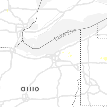
Ohio
| Local Time | Report Details |
|---|---|
| 7:15 PM EDT | Tree down. time estimated by rada in ashtabula county OH, 49.4 miles ENE of Cleveland, OH |
| 8:30 PM EDT | Tree on house. time estimated from rada in geauga county OH, 24.8 miles E of Cleveland, OH |
| 8:34 PM EDT | Tree dow in geauga county OH, 26 miles ENE of Cleveland, OH |
| 8:35 PM EDT | Tree on garage. time estimated from rada in geauga county OH, 25.8 miles E of Cleveland, OH |
| 8:44 PM EDT | Tree down on wires. time estimated from rada in geauga county OH, 29.7 miles E of Cleveland, OH |
Georgia
| Local Time | Report Details |
|---|---|
| 7:45 PM EDT | Emergency manager reported a tree down on a house in the woodstock area. damage unknown. time estimated from rada in cherokee county GA, 25.5 miles NNW of Atlanta, GA |
Wyoming
| Local Time | Report Details |
|---|---|
| 6:49 PM MDT | Quarter sized hail reported near Rock River, WY, 37.3 miles NNW of Laramie, WY, measured one inch hail. |
Maryland
| Local Time | Report Details |
|---|---|
| 9:21 PM EDT | Tree down on house in the 6900 block of anchorage street off of macarthur boulevar in montgomery county MD, 37.8 miles SW of Baltimore, MD |
| 9:37 PM EDT | Several trees down in the 6900 block of macarthur boulevard... some lanes blocke in montgomery county MD, 36.1 miles SW of Baltimore, MD |
Kansas
| Local Time | Report Details |
|---|---|
| 8:34 PM MDT | Storm damage reported in greeley county KS, 63.3 miles NW of Garden City, KS |
| 8:55 PM MDT | Storm damage reported in hamilton county KS, 47.9 miles W of Garden City, KS |
Texas
| Local Time | Report Details |
|---|---|
| 1:30 AM CDT | Storm damage reported in hansford county TX, 87.6 miles NNE of Amarillo, TX |
Connect with Interactive Hail Maps