

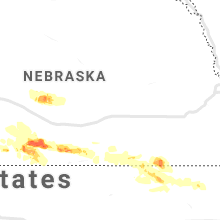
Hail Map for Tuesday, July 9, 2019

Number of Impacted Households on 7/9/2019
0
Impacted by 1" or Larger Hail
0
Impacted by 1.75" or Larger Hail
0
Impacted by 2.5" or Larger Hail
Square Miles of Populated Area Impacted on 7/9/2019
0
Impacted by 1" or Larger Hail
0
Impacted by 1.75" or Larger Hail
0
Impacted by 2.5" or Larger Hail


Hail and Wind Damage Spotted on 7/9/2019
Filter by Report Type:Hail ReportsWind Reports
Minnesota
| Local Time | Report Details |
|---|---|
| 7:40 AM CDT | Tree of 12 to 18 inches diameter blown down into the stree in wilkin county MN, 36.5 miles SE of Fargo, ND |
| 8:55 PM CDT | Winds rocking the vehicle with small to medium sized branches littering the roadway. hail up to half in diamete in otter tail county MN, 69.6 miles ESE of Fargo, ND |
| 9:05 PM CDT | Personal weather station measurement. one mature tree snapped in yar in otter tail county MN, 74.7 miles ESE of Fargo, ND |
Wyoming
| Local Time | Report Details |
|---|---|
| 1:24 PM MDT | Storm damage reported in campbell county WY, 37.5 miles S of Gillette, WY |
| 1:24 PM MDT | Quarter sized hail reported near , , 37.5 miles S of Gillette, WY, mostly nickel size with quarters mixed in. |
| 1:36 PM MDT | Tree limbs dow in campbell county WY, 13 miles SW of Gillette, WY |
| 1:37 PM MDT | Storm damage reported in campbell county WY, 12.2 miles SW of Gillette, WY |
Alabama
| Local Time | Report Details |
|---|---|
| 3:00 PM CDT | Trees down near the intersection of lee rd 147 and lee rd 72. time estimated from rada in lee county AL, 4.3 miles N of Auburn, AL |
| 4:30 PM CDT | Tree down on highway 123 south blocking one lane of traffic just before the railroad track in dale county AL, 78.9 miles S of Auburn, AL |
| 4:35 PM CDT | Two trees down across county road 13 in coffee county AL, 78.2 miles SSW of Auburn, AL |
| 4:40 PM CDT | One tree down and a power pole down on county road 233 a mile north of county road 23 in coffee county AL, 79.9 miles NNE of Miramar Beach, FL |
| 5:00 PM CDT | One tree down across county road 66 in coffee county AL, 64.3 miles NNE of Miramar Beach, FL |
| 7:00 PM CDT | Tree down on hwy 35 going down the mountain. time estimated from rada in cherokee county AL, 49 miles SSW of Chattanooga, TN |
| 7:45 PM CDT | Tree in the road near intersection of cr 33 and cr 14. time estimate in cherokee county AL, 69.6 miles SSW of Chattanooga, TN |
| 8:30 PM CDT | Tree down on cr 567. time estimate in cherokee county AL, 57 miles SSW of Chattanooga, TN |
| 8:50 PM CDT | Multiple trees down in the black creek community. time estimate in etowah county AL, 68.9 miles SSW of Chattanooga, TN |
| 9:00 PM CDT | Multiple trees down along interstate 59 near mile marker 193. time estimate in etowah county AL, 63.2 miles NE of Birmingham, AL |
| 9:00 PM CDT | Tree down near intersection of hwy 278 and hwy 77 with vehicle involved. time estimate in etowah county AL, 53.5 miles NE of Birmingham, AL |
| 9:05 PM CDT | Tree down on gladden rd. time estimate in etowah county AL, 61 miles NE of Birmingham, AL |
South Dakota
| Local Time | Report Details |
|---|---|
| 2:52 PM MDT | Several trees down in ardmore. 70-90 mph winds. delayed repor in fall river county SD, 76.4 miles SSW of Rapid City, SD |
| 2:52 PM MDT | Several trees down in ardmore. 70-90 mph winds. delayed repor in fall river county SD, 76.4 miles SSW of Rapid City, SD |
| 3:40 PM MDT | Hen Egg sized hail reported near Kyle, SD, 70.3 miles SE of Rapid City, SD |
| 3:50 PM MDT | Quarter sized hail reported near Kyle, SD, 78.7 miles SE of Rapid City, SD |
| 4:25 PM MDT | Storm damage reported in pennington county SD, 36.4 miles E of Rapid City, SD |
| 4:38 PM MDT | Ping Pong Ball sized hail reported near Martin, SD, 54.1 miles WNW of Valentine, NE, images show hail of various sizes up to about ping pong ball sized |
| 4:52 PM MDT | Winds between 50 and 70 mph in pennington county SD, 54.2 miles ENE of Rapid City, SD |
| 7:55 PM CDT | Several power poles downed along hwy 53 from 278th street to 279th street. time estimated from radar and nearby observation in tripp county SD, 42.1 miles NE of Valentine, NE |
| 7:56 PM CDT | Storm damage reported in tripp county SD, 43.1 miles NE of Valentine, NE |
| 8:00 PM CDT | Hay bales blown across the road. some vehicles were struck by hay bales and knocked off the road. delayed report. time estimated from rada in tripp county SD, 49.7 miles NE of Valentine, NE |
| 8:05 PM CDT | Storm damage reported in tripp county SD, 47.7 miles NE of Valentine, NE |
| 8:18 PM CDT | 12 foot long tree branch... 6 inches in diameter broken of in gregory county SD, 60.7 miles ENE of Valentine, NE |
| 8:19 PM CDT | Quarter sized hail reported near Winner, SD, 33 miles ENE of Valentine, NE |
| 8:19 PM CDT | Storm damage reported in tripp county SD, 33 miles ENE of Valentine, NE |
Nebraska
| Local Time | Report Details |
|---|---|
| 3:19 PM MDT | Asos station kcdr chadron airport - cd in dawes county NE, 72.8 miles NNE of Scottsbluff, NE |
| 3:31 PM MDT | Quarter sized hail reported near Hay Springs, NE, 83.4 miles NE of Scottsbluff, NE |
| 3:48 PM MDT | Quarter size hail in addition to the strong win in sheridan county NE, 84.6 miles NE of Scottsbluff, NE |
| 6:20 PM CDT | Quarter sized hail reported near Kilgore, NE, 21.1 miles NW of Valentine, NE, dime to quarter sized hail |
| 7:00 PM CDT | Quarter sized hail reported near Wood Lake, NE, 12.2 miles E of Valentine, NE |
| 2:45 AM CDT | Personal weather station kneoxfor in furnas county NE, 81.5 miles WSW of Grand Island, NE |
| 2:56 AM CDT | Personal weather station via davis weatherlin in harlan county NE, 78.9 miles SW of Grand Island, NE |
| 3:27 AM CDT | Quarter sized hail reported near Wilcox, NE, 62.6 miles SW of Grand Island, NE, report via facebook. time estimated from radar. |
| 4:37 AM CDT | Half Dollar sized hail reported near Ruskin, NE, 58.9 miles SSE of Grand Island, NE, mping report. |
| 5:25 AM CDT | Storm damage reported in thayer county NE, 66.5 miles SSE of Grand Island, NE |
Mississippi
| Local Time | Report Details |
|---|---|
| 6:27 PM CDT | Stennis international airport reported a 58 knot wind gust in a thunderstor in hancock county MS, 47.3 miles NE of New Orleans, LA |
Texas
| Local Time | Report Details |
|---|---|
| 7:23 PM CDT | Golf Ball sized hail reported near Pampa, TX, 54.4 miles ENE of Amarillo, TX |
| 7:25 PM CDT | Golf Ball sized hail reported near Pampa, TX, 54.9 miles ENE of Amarillo, TX |
| 7:31 PM CDT | Quarter sized hail reported near Pampa, TX, 54.1 miles ENE of Amarillo, TX |
Kansas
| Local Time | Report Details |
|---|---|
| 4:45 AM CDT | Estimated wind gusts of 55 to 60 mp in jewell county KS, 72.8 miles S of Grand Island, NE |
| 5:31 AM CDT | Storm damage reported in cloud county KS, 63.7 miles WNW of Manhattan, KS |
| 5:35 AM CDT | Storm damage reported in republic county KS, 72.2 miles NW of Manhattan, KS |
| 5:40 AM CDT | Machine shed lost roof. grain bin blown ove in republic county KS, 62.7 miles NW of Manhattan, KS |
| 5:51 AM CDT | Six inch branch broken off tree and power ou in republic county KS, 60.8 miles NW of Manhattan, KS |
| 6:04 AM CDT | Also observed hail around golf ball siz in washington county KS, 46.7 miles NW of Manhattan, KS |
| 6:10 AM CDT | 6-inch diameter limb blown off a tre in washington county KS, 47.6 miles NW of Manhattan, KS |
| 6:23 AM CDT | Storm damage reported in marshall county KS, 36.5 miles NNW of Manhattan, KS |
| 6:28 AM CDT | Several trees down in tow in marshall county KS, 36.7 miles NNW of Manhattan, KS |
| 6:31 AM CDT | Measured gust on weather home weather statio in riley county KS, 19.5 miles NW of Manhattan, KS |
| 6:47 AM CDT | Storm damage reported in marshall county KS, 35 miles N of Manhattan, KS |
Connect with Interactive Hail Maps