

Hail Map for Saturday, June 15, 2019

Number of Impacted Households on 6/15/2019
0
Impacted by 1" or Larger Hail
0
Impacted by 1.75" or Larger Hail
0
Impacted by 2.5" or Larger Hail
Square Miles of Populated Area Impacted on 6/15/2019
0
Impacted by 1" or Larger Hail
0
Impacted by 1.75" or Larger Hail
0
Impacted by 2.5" or Larger Hail


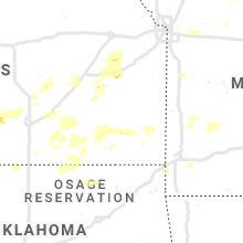


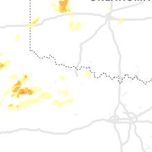

Cities Most Affected by Hail Storms of 6/15/2019
| Hail Size | Demographics of Zip Codes Affected | ||||||
|---|---|---|---|---|---|---|---|
| City | Count | Average | Largest | Pop Density | House Value | Income | Age |
| Hereford, TX | 8 | 2.12 | 3.23 | 15 | $46k | $29.6k | 30.9 |
| Custer City, OK | 2 | 1.75 | 1.75 | 3 | $34k | $33.4k | 47.1 |
| Putnam, OK | 1 | 1.75 | 1.75 | 1 | $39k | $42.5k | 52.0 |
| Fairview, OK | 1 | 1.75 | 1.75 | 10 | $52k | $30.5k | 44.8 |
| Summerfield, TX | 1 | 1.75 | 1.75 | 100 | $0k | $0.0k | 38.8 |
| Kingman, KS | 1 | 1.75 | 1.75 | 15 | $59k | $39.6k | 42.5 |
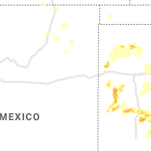
Hail and Wind Damage Spotted on 6/15/2019
Filter by Report Type:Hail ReportsWind Reports
States Impacted
Texas, Oklahoma, Iowa, Minnesota, Missouri, Wyoming, South Dakota, Indiana, Colorado, Louisiana, Kansas, Illinois, KentuckyTexas
| Local Time | Report Details |
|---|---|
| 9:24 AM CDT | Quarter sized hail reported near Justiceburg, TX, 59.3 miles SE of Lubbock, TX, mix of nickels and a few quarters |
| 5:20 PM CDT | Half Dollar sized hail reported near Hereford, TX, 46.7 miles SW of Amarillo, TX |
| 5:26 PM CDT | Golf Ball sized hail reported near Summerfield, TX, 50.1 miles SW of Amarillo, TX |
| 5:34 PM CDT | Quarter sized hail reported near Plainview, TX, 41.9 miles N of Lubbock, TX, report relayed by media. |
| 5:43 PM CDT | Half Dollar sized hail reported near Hereford, TX, 47.5 miles SW of Amarillo, TX, nssl mobile chaser reported half dollar hail already on the ground. hail had been on the ground for awhile. |
| 5:48 PM CDT | Hen Egg sized hail reported near Hereford, TX, 48.8 miles SW of Amarillo, TX, 3 north of summerfield. 56 mm hail measured by calipers. |
| 5:50 PM CDT | Hen Egg sized hail reported near Hereford, TX, 48.4 miles SW of Amarillo, TX, time estimated base on radar. |
| 5:53 PM CDT | Half Dollar sized hail reported near Hereford, TX, 44 miles SW of Amarillo, TX |
| 5:55 PM CDT | Tea Cup sized hail reported near Hereford, TX, 49.1 miles WSW of Amarillo, TX, hail was found on ground off 1058 west of hereford by nssl research team at 601 pm. event time was estimated by radar. |
| 5:56 PM CDT | Hen Egg sized hail reported near Hereford, TX, 41.8 miles SW of Amarillo, TX, co rd 4 and fm 1057 in deaf smith county |
| 5:56 PM CDT | Wind gust recorded of 62 mph in armstrong county TX, 31.8 miles ESE of Amarillo, TX |
| 6:37 PM CDT | Golf Ball sized hail reported near Hereford, TX, 54.3 miles ESE of Tucumcari, NM, time estimated based on radar. |
| 6:37 PM CDT | Wind gust recorded of 62 mph in armstrong county TX, 31.8 miles ESE of Amarillo, TX |
| 6:49 PM CDT | Half Dollar sized hail reported near Floydada, TX, 39.9 miles NE of Lubbock, TX |
| 6:55 PM CDT | Storm damage reported in armstrong county TX, 38.5 miles ESE of Amarillo, TX |
| 7:00 PM CDT | Golf Ball sized hail reported near Hereford, TX, 52.2 miles WSW of Amarillo, TX |
| 7:03 PM CDT | Hen Egg sized hail reported near Hereford, TX, 51.1 miles WSW of Amarillo, TX |
| 7:11 PM CDT | Golf Ball sized hail reported near Hereford, TX, 47.7 miles WSW of Amarillo, TX |
| 7:38 PM CDT | Storm damage reported in gray county TX, 52.9 miles E of Amarillo, TX |
| 7:40 PM CDT | Storm damage reported in motley county TX, 24.8 miles WSW of Childress, TX |
| 8:00 PM CDT | Storm damage reported in gray county TX, 59.5 miles NNW of Childress, TX |
| 8:00 PM CDT | Tractor/trailer rig blown over in pilot parking lot on west side of childress on 287. also veteran memorial wall on the courthouse lawn blew dow in childress county TX, 2.3 miles WSW of Childress, TX |
| 8:01 PM CDT | Storm damage reported in childress county TX, 3.9 miles W of Childress, TX |
| 8:11 PM CDT | Highway 62... 5 miles n of childress in childress county TX, 5.4 miles NNW of Childress, TX |
| 8:27 PM CDT | Large tree limbs down... chimney blown over onto roo in collingsworth county TX, 29 miles N of Childress, TX |
| 8:30 PM CDT | Storm damage reported in hardeman county TX, 16.7 miles ESE of Childress, TX |
| 9:24 PM CDT | Quarter sized hail reported near Justiceburg, TX, 59.3 miles SE of Lubbock, TX, mix of nickels and a few quarters |
| 10:01 PM CDT | 54 knot peak gust measured at the bgd asos in hutchinson county TX, 41.9 miles NE of Amarillo, TX |
| 10:04 PM CDT | Storm damage reported in hutchinson county TX, 48.7 miles NNE of Amarillo, TX |
| 10:20 PM CDT | Storm damage reported in hansford county TX, 87.6 miles NNE of Amarillo, TX |
| 10:29 PM CDT | Broken window due to wind. time estimated from rada in roberts county TX, 62.6 miles ENE of Amarillo, TX |
| 10:35 PM CDT | Roof blown off of a dwelling. location approximate. time estimated from nearby repor in knox county TX, 68.2 miles SSE of Childress, TX |
| 10:35 PM CDT | Six to seven powerpoles snapped on fm2279. time estimated based on nearby report in knox county TX, 66.7 miles N of Abilene, TX |
| 10:35 PM CDT | Corrects previous tstm wnd dmg report from knox city. large tree limbs and powerlines downed from obrien to about 5 miles north of knox city. also 1 inch hai in knox county TX, 67.1 miles N of Abilene, TX |
| 11:16 PM CDT | 51 knot peak gust at pyx awos. since awos lacks pk spd metar remarks... approximate time was estimated from rada in ochiltree county TX, 75.3 miles W of Woodward, OK |
| 11:50 PM CDT | Facebook message relayed from em. power lines down in hollida in archer county TX, 12.8 miles WSW of Wichita Falls, TX |
| 11:54 PM CDT | Multiple trees downe in wichita county TX, 1.4 miles SSW of Wichita Falls, TX |
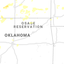
Oklahoma
| Local Time | Report Details |
|---|---|
| 11:06 AM CDT | 6-8 inch diameter tree snappe in grady county OK, 20.1 miles SW of Oklahoma City, OK |
| 7:10 PM CDT | Quarter sized hail reported near Oakwood, OK, 40.7 miles SE of Woodward, OK |
| 7:40 PM CDT | Ping Pong Ball sized hail reported near Oakwood, OK, 42.8 miles SE of Woodward, OK |
| 7:51 PM CDT | Quarter sized hail reported near Seiling, OK, 32.7 miles SE of Woodward, OK |
| 7:57 PM CDT | Half Dollar sized hail reported near Seiling, OK, 32.7 miles SE of Woodward, OK |
| 8:10 PM CDT | Storm damage reported in cimarron county OK, 108.8 miles NNW of Amarillo, TX |
| 8:30 PM CDT | Hollis sit in harmon county OK, 27.3 miles NE of Childress, TX |
| 8:35 PM CDT | Storm damage reported in beckham county OK, 58 miles NNE of Childress, TX |
| 8:40 PM CDT | Storm damage reported in harmon county OK, 27.8 miles NE of Childress, TX |
| 8:40 PM CDT | 4-5 power poles snapped with lines across road at county roads east/west 20 and north/south 26. extremely low visibility was also reported due to blowing dust east of b in cimarron county OK, 111.7 miles NNW of Amarillo, TX |
| 8:41 PM CDT | Golf Ball sized hail reported near Putnam, OK, 49 miles SE of Woodward, OK |
| 9:06 PM CDT | Estimate in beckham county OK, 69.9 miles S of Woodward, OK |
| 9:11 PM CDT | Power flashes also see in beckham county OK, 69.9 miles S of Woodward, OK |
| 9:15 PM CDT | At elk city regional airpor in beckham county OK, 69.2 miles S of Woodward, OK |
| 9:16 PM CDT | Golf Ball sized hail reported near Fairview, OK, 28.6 miles E of Woodward, OK, south of bouse jct on hwy 281. |
| 9:20 PM CDT | Roof blown off house. vehicles overturne in custer county OK, 52.9 miles SSE of Woodward, OK |
| 9:25 PM CDT | Golf Ball sized hail reported near Custer City, OK, 53.5 miles SSE of Woodward, OK, corrects previous hail report from 7 nw custer city. |
| 9:30 PM CDT | Storm damage reported in kiowa county OK, 76.6 miles ENE of Childress, TX |
| 9:32 PM CDT | Golf Ball sized hail reported near Custer City, OK, 53.5 miles SSE of Woodward, OK |
| 9:33 PM CDT | Clinton/sherman airpor in washita county OK, 75.5 miles S of Woodward, OK |
| 9:35 PM CDT | Storm damage reported in washita county OK, 73.2 miles SSE of Woodward, OK |
| 9:50 PM CDT | Windows blown out of hous in custer county OK, 56 miles SSE of Woodward, OK |
| 9:55 PM CDT | Storm damage reported in custer county OK, 70.5 miles W of Oklahoma City, OK |
| 10:10 PM CDT | Storm damage reported in caddo county OK, 57.3 miles WSW of Oklahoma City, OK |
| 11:14 PM CDT | Twitter report... 60-70 mph estimate in cleveland county OK, 11.9 miles S of Oklahoma City, OK |
| 11:17 PM CDT | Garage door blown i in cleveland county OK, 9.3 miles S of Oklahoma City, OK |
| 12:00 AM CDT | Powerpoles and large trees snapped at base. damage to mobile hom in lincoln county OK, 27.6 miles ENE of Oklahoma City, OK |
| 12:02 AM CDT | Storm damage reported in pottawatomie county OK, 34.8 miles ESE of Oklahoma City, OK |
| 12:07 AM CDT | Quarter sized hail reported near Shawnee, OK, 34.8 miles ESE of Oklahoma City, OK |
| 1:11 AM CDT | Estimated 50 to 60 mph wind gust relayed via spotter network in tulsa county OK, 14.5 miles S of Tulsa, OK |
| 1:19 AM CDT | Measured gust to 60 mph relayed via spotter network in tulsa county OK, 17 miles SSE of Tulsa, OK |
Iowa
| Local Time | Report Details |
|---|---|
| 1:24 PM CDT | Quarter sized hail reported near Remsen, IA, 41.6 miles WNW of Storm Lake, IA |
| 2:10 PM CDT | Trees down in eldor in hardin county IA, 54.5 miles S of Mason City, IA |
| 3:35 PM CDT | Tree snapped in fort dodge near great western bank. relayed via social medi in webster county IA, 53 miles E of Storm Lake, IA |
| 4:20 PM CDT | Large limbs down around perry. time estimate in dallas county IA, 30.4 miles NW of Des Moines, IA |
| 4:40 PM CDT | Trees down in gilbert - relayed by law enforcemen in story county IA, 35.9 miles N of Des Moines, IA |
| 4:50 PM CDT | Report of a tree down that was blocking the road at the intersection of 270th and y av in story county IA, 26.6 miles N of Des Moines, IA |
| 4:53 PM CDT | Reported at ames municipal airpor in story county IA, 27.6 miles N of Des Moines, IA |
| 4:53 PM CDT | 18 inch tree snapped. tree did have some rot. picture via twitte in story county IA, 29.7 miles N of Des Moines, IA |
| 4:55 PM CDT | Large tree downed near slater. report relayed via who-t in story county IA, 20.3 miles N of Des Moines, IA |
| 5:05 PM CDT | Tree down in maxwell relayed by law enforcemen in story county IA, 23.5 miles NNE of Des Moines, IA |
| 5:26 PM CDT | Reported at marshalltown municipal airpor in marshall county IA, 50.8 miles NE of Des Moines, IA |
| 5:28 PM CDT | Tree and power pole damage via social media/snapchat. time estimate in marshall county IA, 47.9 miles NE of Des Moines, IA |
| 5:33 PM CDT | Woi-tv viewer shared photo large tree that snapped near sw 18th street and army post rd in des moine in polk county IA, 4.3 miles SSW of Des Moines, IA |
| 5:33 PM CDT | Trained spotter estimates 60 mph gust near blank park zo in polk county IA, 4.9 miles S of Des Moines, IA |
| 5:34 PM CDT | Reported at des moines international airpor in polk county IA, 4.1 miles SSW of Des Moines, IA |
| 5:35 PM CDT | Couple large tree limbs down with one estimated around a foot in diameter falling and damaging a chain link fence on wade street. another 5 inch diameter branch down on in polk county IA, 4.9 miles S of Des Moines, IA |
| 5:35 PM CDT | Tree branch and powerline down. via social media/snapchat. time estimated from rada in polk county IA, 4.2 miles S of Des Moines, IA |
| 5:37 PM CDT | Report of trees down. time estimated from rada in tama county IA, 55.3 miles WNW of Cedar Rapids, IA |
| 5:40 PM CDT | Report of trees down. time estimated from rada in tama county IA, 53.4 miles W of Cedar Rapids, IA |
| 6:17 PM CDT | Time estimated from rada in iowa county IA, 36.1 miles WSW of Cedar Rapids, IA |
| 6:31 PM CDT | Near hwy 30 and ia 13 in benton county IA, 29.2 miles W of Cedar Rapids, IA |
| 6:54 PM CDT | Sustained 50-55 mph... relayed by emergency managemen in benton county IA, 9.7 miles W of Cedar Rapids, IA |
| 7:01 PM CDT | Quarter sized hail reported near Albia, IA, 54.9 miles SE of Des Moines, IA, mping report. |
| 7:05 PM CDT | A tree was damaged in far western ottumwa. time estimated. via social media/snapcha in wapello county IA, 56.2 miles NW of Kahoka, MO |
| 8:28 PM CDT | Power lines and trees down. possible tornado damage. time estimated from rada in des moines county IA, 58.2 miles NE of Kahoka, MO |
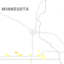
Minnesota
| Local Time | Report Details |
|---|---|
| 1:50 PM CDT | Corrects previous tstm wnd gst report from 2 nnw blue earth with maximum measured gust. measured at mndot rwis near blue eart in faribault county MN, 58.3 miles NW of Mason City, IA |
| 2:03 PM CDT | At least 1 power pole was sheared off near the ground along mn state highway 26 in murray county MN, 55.6 miles ENE of Sioux Falls, SD |
| 2:20 PM CDT | Large tree limb down... damaging a camper and a truc in blue earth county MN, 65.9 miles NW of Mason City, IA |
| 2:50 PM CDT | Tree branches 2 inches in diameter were reported broken. minor flash flooding and nickel sized hail was also occurrin in jackson county MN, 71.3 miles N of Storm Lake, IA |
| 3:25 PM CDT | Quarter sized hail reported near Alden, MN, 41.5 miles NNW of Mason City, IA |
| 4:45 PM CDT | Quarter sized hail reported near Spring Valley, MN, 55.4 miles NE of Mason City, IA |
| 4:53 PM CDT | Ping Pong Ball sized hail reported near Spring Valley, MN, 53.2 miles NE of Mason City, IA, flooding also reported at the intersection of highway 16 and 63. |
| 5:14 PM CDT | Video from twitter... possible tornad in fillmore county MN, 50.1 miles ENE of Mason City, IA |
Missouri
| Local Time | Report Details |
|---|---|
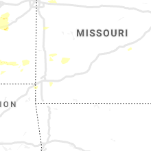
| 4:25 PM CDT | Tree limbs and power lines knocked dow in holt county MO, 79.4 miles NNW of Kansas City, MO |
| 7:03 PM CDT | Half Dollar sized hail reported near Jamesport, MO, 73 miles NE of Kansas City, MO |
| 7:19 PM CDT | Storm damage reported in grundy county MO, 79.3 miles NE of Kansas City, MO |
| 7:20 PM CDT | 2 foot diameter tree blown dow in grundy county MO, 85.4 miles NE of Kansas City, MO |
| 7:34 PM CDT | Ping Pong Ball sized hail reported near Laredo, MO, 88 miles NE of Kansas City, MO |
| 8:08 PM CDT | Quarter sized hail reported near Green Castle, MO, 59.3 miles W of Kahoka, MO, pea to quarter sized hail. |
| 11:20 PM CDT | Two tree limbs...approx 8 inch in diameter...down. other smaller tree limbs blown down. relayed by wgem. time estimated by rada in ralls county MO, 57 miles SSE of Kahoka, MO |
Wyoming
| Local Time | Report Details |
|---|---|
| 3:57 PM MDT | Ping Pong Ball sized hail reported near Riverton, WY, 18.6 miles NNW of Riverton, WY, almost covered the ground |
South Dakota
| Local Time | Report Details |
|---|---|
| 5:00 PM CDT | Heavy gusty winds... did not see hai in hamlin county SD, 71.5 miles WSW of Montevideo, MN |
| 6:45 PM CDT | Report via social medi in moody county SD, 33.4 miles N of Sioux Falls, SD |
Indiana
| Local Time | Report Details |
|---|---|
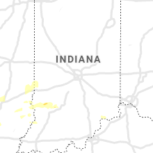
| 6:06 PM EDT | Healthy tree uprooted over main street west of coatesville. time estimated from rada in hendricks county IN, 29.3 miles W of Indianapolis, IN |
| 6:50 PM EDT | Large trees and utility line blown down and barn destroyed near north mt tabor road and west cowden road. time estimated from rada in monroe county IN, 42.5 miles SW of Indianapolis, IN |
| 6:51 PM EDT | Multiple trees down and houses destroyed in red hill road area. time estimated from rada in monroe county IN, 43.1 miles SW of Indianapolis, IN |
| 7:05 PM EDT | Pictures sent via social media of several large limbs across mann road. time estimated from rada in morgan county IN, 11.7 miles SSW of Indianapolis, IN |
| 7:10 PM EDT | Storm damage reported in monroe county IN, 49.4 miles SSW of Indianapolis, IN |
| 7:25 PM EDT | Large trees snapped and uproote in monroe county IN, 37.2 miles SSW of Indianapolis, IN |
| 7:27 PM EDT | Damage to roof and wall of alro steel. damage to apartment building roof. time estimated from rada in marion county IN, 4.5 miles SE of Indianapolis, IN |
| 7:30 PM EDT | Significant damage reported in and around beech grove with numerous trees damaged or snapped as well as structural damage to several roofs. possible tornado damag in marion county IN, 4.5 miles SE of Indianapolis, IN |
| 7:37 PM EDT | Trees and utility lines down... with the davis and raymond streets off of brookville road appearing to be the hardest hit. time estimated from rada in marion county IN, 8.7 miles ESE of Indianapolis, IN |
| 7:41 PM EDT | Several houses with shingles blown off and numerous tree limbs snapped in hymera. time estimated from rada in sullivan county IN, 61 miles ESE of Mattoon, IL |
| 7:56 PM EDT | Several trees downed in spring lake with some power poles down as wel in hancock county IN, 16.5 miles E of Indianapolis, IN |
| 8:05 PM EDT | Spotter reported numerous 4 to 8 inch tree limbs snapped as well as a few small trees uprooted north of springpor in delaware county IN, 44.9 miles ENE of Indianapolis, IN |
| 8:05 PM EDT | Healthy 10 foot tall tree snappe in hancock county IN, 21.4 miles E of Indianapolis, IN |
| 8:13 PM EDT | Law enforcement reported uprooted tree partially covering shoulder along i-70 northeast of greenfield. time estimated from rada in hancock county IN, 24.9 miles E of Indianapolis, IN |
| 8:30 PM EDT | Estimated wind gust of 60 mph fell numerous trees...including the following approximate diameters...30 inches...24 inches...18 inches. spotter saw the trees fall and fe in bartholomew county IN, 41.4 miles SSE of Indianapolis, IN |
| 8:47 PM EDT | Major damage at hulsbosch dairy farm on 700 west north of 700 south...currently putting down multiple cows and calves. damage on nearby shireman dairy farm and the blau in decatur county IN, 46.4 miles SE of Indianapolis, IN |
| 9:28 PM EDT | Significant roof damage reported at 7379 south country road 900 west. relayed report by n9ith. time indicated is time report was receive in decatur county IN, 45.7 miles SE of Indianapolis, IN |
| 5:10 AM EDT | Social media report of a power outage near the intersection of state roads 446 and 50. time estimated from rada in lawrence county IN, 62 miles S of Indianapolis, IN |
| 6:31 AM EDT | A few trees were downed along state road 56 outside of veva in switzerland county IN, 40 miles SW of Cincinnati, OH |
Colorado
| Local Time | Report Details |
|---|---|
| 4:45 PM MDT | 6 inch diameter tree branches blown dow in otero county CO, 60.9 miles E of Pueblo, CO |
Louisiana
| Local Time | Report Details |
|---|---|
| 6:15 PM CDT | Sheriff department reports trees down on hwy 518... just northwest of lake claiborn in claiborne county LA, 52.8 miles ENE of Shreveport, LA |
Kansas
| Local Time | Report Details |
|---|---|
| 9:36 PM CDT | Half Dollar sized hail reported near Kingman, KS, 43.1 miles W of Wichita, KS |
| 9:36 PM CDT | Golf Ball sized hail reported near Kingman, KS, 42.5 miles W of Wichita, KS, precipitation was all hail... no rain |
| 10:11 PM CDT | Quarter sized hail reported near Colwich, KS, 16.2 miles NW of Wichita, KS, reported along highway 96 northwest of colwich |
| 10:35 PM CDT | Quarter sized hail reported near Quenemo, KS, 60.5 miles WSW of Kansas City, MO, at pomona lake. report via wibw 13 weather social media. |
| 2:08 AM CDT | Storm damage reported in cowley county KS, 40 miles SSE of Wichita, KS |
Illinois
| Local Time | Report Details |
|---|---|
| 9:37 PM CDT | Tree dow in knox county IL, 30.9 miles WNW of Peoria, IL |
| 9:39 PM CDT | Power poles and trees snapped north of tow in fulton county IL, 31.8 miles W of Peoria, IL |
| 9:49 PM CDT | Tree down on house. time estimated by rada in henry county IL, 53.6 miles NNW of Peoria, IL |
| 9:58 PM CDT | Storm damage reported in peoria county IL, 21 miles WNW of Peoria, IL |
| 10:31 PM CDT | Tree limbs dow in tazewell county IL, 11.1 miles SE of Peoria, IL |
| 10:43 PM CDT | Power line dow in tazewell county IL, 23.3 miles SE of Peoria, IL |
| 11:02 PM CDT | Tree down at intersection of market and lee streets just west of downtow in mclean county IL, 34.2 miles ESE of Peoria, IL |
| 11:54 PM CDT | Storm damage reported in champaign county IL, 42.7 miles N of Mattoon, IL |
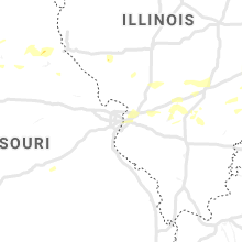
| 1:52 AM CDT | Quarter sized hail reported near Caseyville, IL, 9.2 miles E of Saint Louis, MO, range of hail sizes. hail fell for approximately 2 minutes beginning at 0152 cdt. |
| 2:05 AM CDT | Storm damage reported in cumberland county IL, 20.4 miles S of Mattoon, IL |
| 2:55 AM CDT | Storm damage reported in crawford county IL, 50.3 miles SE of Mattoon, IL |
Kentucky
| Local Time | Report Details |
|---|---|
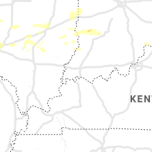
| 11:39 AM UTC | Trees down in mason county KY, 51.9 miles SE of Cincinnati, OH |
Connect with Interactive Hail Maps