

Hail Map for Wednesday, June 5, 2019

Number of Impacted Households on 6/5/2019
0
Impacted by 1" or Larger Hail
0
Impacted by 1.75" or Larger Hail
0
Impacted by 2.5" or Larger Hail
Square Miles of Populated Area Impacted on 6/5/2019
0
Impacted by 1" or Larger Hail
0
Impacted by 1.75" or Larger Hail
0
Impacted by 2.5" or Larger Hail


Cities Most Affected by Hail Storms of 6/5/2019
| Hail Size | Demographics of Zip Codes Affected | ||||||
|---|---|---|---|---|---|---|---|
| City | Count | Average | Largest | Pop Density | House Value | Income | Age |
| Keosauqua, IA | 2 | 2.75 | 2.75 | 13 | $56k | $32.7k | 48.2 |
| Hortonville, WI | 2 | 2.50 | 2.50 | 121 | $122k | $57.5k | 39.8 |
| Hazel Green, KY | 2 | 1.88 | 2.00 | 25 | $46k | $22.6k | 41.8 |
| Bonaparte, IA | 1 | 2.00 | 2.00 | 14 | $39k | $34.2k | 36.6 |
| Tarzan, TX | 1 | 2.00 | 2.00 | 0 | $82k | $35.0k | 34.8 |
| Winigan, MO | 1 | 1.75 | 1.75 | 3 | $10k | $31.9k | 48.8 |
| Salt Lick, KY | 1 | 1.75 | 1.75 | 30 | $65k | $24.1k | 40.2 |
| Salem, IN | 1 | 1.75 | 1.75 | 75 | $78k | $36.3k | 39.5 |
Hail and Wind Damage Spotted on 6/5/2019
Filter by Report Type:Hail ReportsWind Reports
States Impacted
Iowa, Alabama, Illinois, Indiana, Georgia, Ohio, South Carolina, North Carolina, Missouri, Virginia, Texas, Delaware, New Mexico, Tennessee, Maryland, Kentucky, Wisconsin, Nebraska, Kansas, OklahomaIowa
| Local Time | Report Details |
|---|---|
| 9:55 AM CDT | Baseball sized hail reported near Keosauqua, IA, 25.1 miles NNW of Kahoka, MO, also small branches down. |
| 9:57 AM CDT | Half Dollar sized hail reported near Keosauqua, IA, 23.2 miles NNW of Kahoka, MO, quarter to half dollar sized hail. very heavy rainfall and gusty winds. leaves off some trees. time estimated based on radar and other reports. |
| 10:00 AM CDT | Baseball sized hail reported near Keosauqua, IA, 25.1 miles NNW of Kahoka, MO, windows knocked out in the high school building in keosauqua. no injuries. |
| 10:15 AM CDT | Hen Egg sized hail reported near Bonaparte, IA, 14.5 miles NNW of Kahoka, MO |
| 10:17 AM CDT | Quarter sized hail reported near Farmington, IA, 14.3 miles NNW of Kahoka, MO |
Alabama
| Local Time | Report Details |
|---|---|
| 10:32 AM CDT | A tree was knocked down onto a power line causing a power outage in the area. also... the madison county sheriff reported small hail in the same general area. time esti in madison county AL, 63.7 miles E of Florence, AL |
Illinois
| Local Time | Report Details |
|---|---|
| 11:48 AM CDT | 6 power poles down in logan county IL, 33.1 miles S of Peoria, IL |
| 11:53 AM CDT | 7 trees down... largest 18 inches in diameter in logan county IL, 39.1 miles SSE of Peoria, IL |
| 11:53 AM CDT | 7 trees down... largest 18 inches in diameter in logan county IL, 30.7 miles S of Peoria, IL |
| 3:35 PM CDT | Quarter sized hail reported near Ashland, IL, 60.9 miles SSW of Peoria, IL |
| 3:35 PM CDT | Wall cloud with slight rotation in cass county IL, 60.9 miles SSW of Peoria, IL |
| 3:50 PM CDT | Power lines down on old jacksonville rd in morgan county IL, 72.6 miles N of Saint Louis, MO |
| 3:55 PM CDT | Multiple power lines down in sangamon county IL, 64.8 miles WNW of Mattoon, IL |
| 3:56 PM CDT | Tree down at grade school and several large branches down on road east of school in sangamon county IL, 64.8 miles WNW of Mattoon, IL |
| 4:06 PM CDT | Pulic report of a roof and siding ripped off of a barn in jeisyville...relayed through social medi in christian county IL, 55.7 miles W of Mattoon, IL |
| 4:10 PM CDT | Power lines down il-104 at johns creek rd in sangamon county IL, 68.5 miles NNE of Saint Louis, MO |
| 4:16 PM CDT | Downed power lines and trees in sangamon county IL, 70 miles NNE of Saint Louis, MO |
| 4:17 PM CDT | 25-30ft tree uprooted... about 24 inch diameter in sangamon county IL, 69.3 miles NNE of Saint Louis, MO |
| 4:20 PM CDT | Downed tree on a house and downed power lines in sangamon county IL, 64.8 miles W of Mattoon, IL |
| 4:25 PM CDT | Storm damage reported in sangamon county IL, 64.8 miles W of Mattoon, IL |
| 4:25 PM CDT | Multiple trees and powerlines down. one on house in sangamon county IL, 64.8 miles W of Mattoon, IL |
| 4:28 PM CDT | Several power lines blown down on the northeast side of raymond as well as numerous tree limb in montgomery county IL, 59.1 miles NE of Saint Louis, MO |
| 4:35 PM CDT | Roof damage at hickory estates in christian county IL, 47.3 miles W of Mattoon, IL |
| 4:38 PM CDT | Storm damage reported in christian county IL, 51.1 miles W of Mattoon, IL |
| 4:45 PM CDT | Storm damage reported in wayne county IL, 63.1 miles SSW of Mattoon, IL |
| 4:48 PM CDT | Storm damage reported in montgomery county IL, 58 miles WSW of Mattoon, IL |
| 4:55 PM CDT | Power line down on house in shelby county IL, 31.9 miles WSW of Mattoon, IL |
| 5:01 PM CDT | Large tree branch down at kitchell park in christian county IL, 38.2 miles W of Mattoon, IL |
| 5:10 PM CDT | Tree limbs down... one blocking a city street. some shingle damage on a residenc in montgomery county IL, 54.4 miles WSW of Mattoon, IL |
| 5:18 PM CDT | Large tree down on a car in clark county IL, 44.2 miles E of Mattoon, IL |
| 5:40 PM CDT | Trees blown down... one uprooted. many branches and limbs dow in marion county IL, 61.2 miles E of Saint Louis, MO |
| 6:03 PM CDT | Report of approximately 30 trees damaged southeast of golden gat in wayne county IL, 41.9 miles NW of Evansville, IN |
| 7:35 PM CDT | Tree branches blown dow in monroe county IL, 12.9 miles S of Saint Louis, MO |
Indiana
| Local Time | Report Details |
|---|---|
| 2:24 PM EDT | Several medium to large trees uprooted on south 9th street. relayed via social media. time estimated from rada in tippecanoe county IN, 59.2 miles NW of Indianapolis, IN |
| 2:28 PM EDT | Three pictures received of large tree limbs that had fallen on cars near brady lane. numerous other pictures of tree damage around lafayett in tippecanoe county IN, 56.6 miles NW of Indianapolis, IN |
| 2:29 PM EDT | Storm damage reported in tippecanoe county IN, 57.7 miles NW of Indianapolis, IN |
| 2:48 PM EDT | Quarter sized hail reported near Lafayette, IN, 55.5 miles NW of Indianapolis, IN, time estimated from radar. |
| 3:20 PM EDT | At the intersection of south 500e and east 1000s in se tippecanoe c in tippecanoe county IN, 49.3 miles NW of Indianapolis, IN |
| 3:58 PM EDT | Trees down on roads in linde in montgomery county IN, 49.4 miles NW of Indianapolis, IN |
| 4:20 PM EDT | Half Dollar sized hail reported near Crane, IN, 72.6 miles NNE of Evansville, IN, corrects time on previous hail report from crane. time estimated from radar. picture sent via social media. |
| 5:00 PM EDT | Trees down in the area. time estimated from rada in rush county IN, 43.9 miles E of Indianapolis, IN |
| 5:04 PM EDT | Reports of trees down across the area... roof torn off small barn. em says it is all straight line winds. time estimated from rada in rush county IN, 46.2 miles ESE of Indianapolis, IN |
| 5:05 PM EDT | Numerous trees down in se rush county. time estimated from rada in rush county IN, 45 miles ESE of Indianapolis, IN |
| 5:18 PM EDT | Power outage and tree on house. time estimated from rada in lawrence county IN, 65.5 miles NW of Louisville, KY |
| 5:22 PM EDT | Wires down in fayette county IN, 47.2 miles NW of Cincinnati, OH |
| 5:38 PM EDT | Tree down along 840 n and 450 in orange county IN, 59.5 miles NW of Louisville, KY |
| 5:44 PM EDT | Asos station khuf terre haut in vigo county IN, 57.6 miles E of Mattoon, IL |
| 5:50 PM EDT | Numerous trees and power lines down across the area. time estimated from rada in vigo county IN, 57.6 miles E of Mattoon, IL |
| 5:57 PM EDT | Multiple trees and power lines down at sr 250 and graham r in jefferson county IN, 50.4 miles WSW of Cincinnati, OH |
| 5:59 PM EDT | Report of trees down along state road 62 near china manville r in jefferson county IN, 48.9 miles WSW of Cincinnati, OH |
| 6:00 PM EDT | Damage to trees and power lines southeast of columbu in bartholomew county IN, 44 miles SSE of Indianapolis, IN |
| 6:05 PM EDT | Debris in the roadway (barn siding) on sr 60 in campbellsburg... i in washington county IN, 54.1 miles NNW of Louisville, KY |
| 6:18 PM EDT | Large tree down on a car in vigo county IN, 45.2 miles E of Mattoon, IL |
| 6:20 PM EDT | Half Dollar sized hail reported near Crane, IN, 72.6 miles NNE of Evansville, IN, time estimated from radar. picture sent via social media. |
| 6:23 PM EDT | Tree down in claysville... in along w lost river r in washington county IN, 53.3 miles NW of Louisville, KY |
| 6:47 PM EDT | Quarter sized hail reported near Orleans, IN, 51.3 miles NW of Louisville, KY |
| 6:50 PM EDT | Golf Ball sized hail reported near Salem, IN, 49.2 miles NW of Louisville, KY |
| 7:01 PM EDT | One tree down. time estimated from radar dat in switzerland county IN, 40.9 miles SW of Cincinnati, OH |
| 7:05 PM EDT | Multiple trees down along crone rd as well as a tree down on power line in clark county IN, 34.1 miles N of Louisville, KY |
| 6:30 PM CDT | Approximately 1000 customers without power in the hazelton/patoka areas. time is estimate in gibson county IN, 29.9 miles N of Evansville, IN |
| 6:30 PM CDT | Several trees and power lines down in town. time estimated by rada in gibson county IN, 26.4 miles N of Evansville, IN |
| 7:10 PM CDT | Snapped power line near hwy 41 and hwy 68 intersectio in gibson county IN, 15.4 miles N of Evansville, IN |
| 8:50 PM EDT | Numerous trees down county wid in orange county IN, 56.9 miles NW of Louisville, KY |
| 8:59 PM EDT | Trees down multiple locations along 3 in orange county IN, 49 miles NW of Louisville, KY |
| 9:10 PM EDT | Trees down e bacon hollow r in crawford county IN, 44.7 miles NW of Louisville, KY |
| 9:23 PM EDT | Trees and power lines down grantsburg... i in crawford county IN, 45.7 miles WNW of Louisville, KY |
Georgia
| Local Time | Report Details |
|---|---|
| 2:36 PM EDT | A tree was reported down near the intersection of overlook ave and riverdale driv in bibb county GA, 73.8 miles SE of Atlanta, GA |
| 3:48 PM EDT | A tree was reported down near the intersection of highway 57 and chandler roa in emanuel county GA, 62.5 miles SSW of Augusta, GA |
| 4:59 PM EDT | Tree down reported at midland road and helmey drive. tree down at midland road and courthouse roa in effingham county GA, 20 miles NW of Savannah, GA |
| 5:00 PM EDT | Tree down reported at midland road and low ground road. additional trees down between cross street in effingham county GA, 18.3 miles NW of Savannah, GA |
Ohio
| Local Time | Report Details |
|---|---|
| 2:45 PM EDT | Numerous large tree branches and multiple power poles dow in wood county OH, 90.9 miles W of Cleveland, OH |
| 3:26 PM EDT | Trees down and power lines down. fence blown into neighbors yar in wood county OH, 89.9 miles W of Cleveland, OH |
| 3:59 PM EDT | Tree down on vehicl in marion county OH, 43 miles N of Columbus, OH |
| 4:36 PM EDT | Quarter sized hail reported near Marion, OH, 41.9 miles NNW of Columbus, OH |
| 4:58 PM EDT | Large tree down at n. east street and murray stree in crawford county OH, 54.3 miles NNE of Columbus, OH |
| 4:58 PM EDT | Trees dow in crawford county OH, 54.1 miles NNE of Columbus, OH |
| 4:58 PM EDT | Tree dow in crawford county OH, 54.4 miles NNE of Columbus, OH |
| 4:58 PM EDT | Garage blew dow in crawford county OH, 55 miles NNE of Columbus, OH |
| 5:00 PM EDT | Broken 2-3 tree limbs and with power lines and utility pole down on sr 1 in crawford county OH, 58.5 miles N of Columbus, OH |
| 5:02 PM EDT | Tree dow in crawford county OH, 54.8 miles NNE of Columbus, OH |
| 5:41 PM EDT | Tree down blocking west grant stree in portage county OH, 29.9 miles SE of Cleveland, OH |
| 5:51 PM EDT | Tree dow in holmes county OH, 61.3 miles SSW of Cleveland, OH |
| 6:00 PM EDT | Multiple trees knocked down from thunderstorm wind in licking county OH, 39.2 miles ENE of Columbus, OH |
| 6:04 PM EDT | Tree down in apple cree in wayne county OH, 52.6 miles S of Cleveland, OH |
| 6:30 PM EDT | Power pole dow in holmes county OH, 61.7 miles NE of Columbus, OH |
| 6:39 PM EDT | Quarter sized hail reported near Cincinnati, OH, 5.8 miles WSW of Cincinnati, OH, quarter hail in delhi. |
South Carolina
| Local Time | Report Details |
|---|---|
| 3:10 PM EDT | Around 100 power outages reported in the city of darlington with power lines down outside of the city. event first reported at 310 p in darlington county SC, 76.4 miles N of Charleston, SC |
| 3:14 PM EDT | At 314 pm... law enforecement reported power lines down across mciver rd and e marion highway ne of florenc in florence county SC, 71.5 miles NNE of Charleston, SC |
| 3:15 PM EDT | Public report of isolated minor roof damage such as missing shingles and chimney caps blown from chimneys in erhardt. time estimated by rada in bamberg county SC, 58.3 miles W of Charleston, SC |
| 3:22 PM EDT | Tree down on hickory hill road between pocotaligo road and two sisters ferry road. tree down on 3rd street northeas in hampton county SC, 50.3 miles N of Savannah, GA |
| 3:26 PM EDT | Sc highway patrol reported tree down at the intersection of sunrise road and beavers pass roa in colleton county SC, 46.2 miles W of Charleston, SC |
| 3:26 PM EDT | Sc highway patrol reported tree down at the 1000 block of beavers pass roa in colleton county SC, 46.3 miles W of Charleston, SC |
| 3:31 PM EDT | Warning point reported tree down highway 278 between almeda and pocotaligo roa in hampton county SC, 51 miles N of Savannah, GA |
| 3:35 PM EDT | Public reported multiple structures damaged. a large... wood playhouse was tossed into the air and crashed into a chain-link fence. picture was supplied with the report in florence county SC, 68.1 miles NNE of Charleston, SC |
| 3:40 PM EDT | Sc highway patrol reported tree down at the intersection of penny creek road and tabor roa in colleton county SC, 47.6 miles WSW of Charleston, SC |
| 4:09 PM EDT | Sc highway patrol reported tree down at stoney brooke lane and firetower roa in jasper county SC, 38.8 miles N of Savannah, GA |
North Carolina
| Local Time | Report Details |
|---|---|
| 3:16 PM EDT | Half Dollar sized hail reported near , , 60.6 miles SSW of Raleigh, NC, large hail fell just north of raeford. |
| 4:01 PM EDT | Reports of trees and power lines down near lillington. time estimated by rada in harnett county NC, 30 miles SSW of Raleigh, NC |
| 4:20 PM EDT | Large tree down reported. time estimated from rada in harnett county NC, 19.8 miles SSW of Raleigh, NC |
| 4:27 PM EDT | Tree down on s walden pond rd in benso in johnston county NC, 24.5 miles SSE of Raleigh, NC |
| 4:40 PM EDT | Tree down at vinson rd and hidden valley d in johnston county NC, 19.1 miles SE of Raleigh, NC |
| 5:23 PM EDT | Corrects previous tstm wnd dmg report from 3 ne glenview. tree reported down across roadway. time estimated by rada in halifax county NC, 55.7 miles ENE of Raleigh, NC |
| 5:40 PM EDT | Large branch blocking roadway. time estimated by rada in nash county NC, 44.8 miles ENE of Raleigh, NC |
| 5:58 PM EDT | Greene co 911 center reports a large tree limb on the roadway near the intersection of sand pit rd and bynum rd. time estimated from rada in greene county NC, 51.1 miles ESE of Raleigh, NC |
| 6:00 PM EDT | Tree reported down near burnette farm rd and us hwy 64. time estimated by rada in edgecombe county NC, 67.7 miles E of Raleigh, NC |
| 6:20 PM EDT | Tree down near murfeesbor in hertford county NC, 62.3 miles WSW of Virginia Beach, VA |
| 6:46 PM EDT | Trees down near eur in gates county NC, 49.4 miles WSW of Virginia Beach, VA |
| 9:23 PM EDT | Tree reported down across roadway. time estimated by rada in halifax county NC, 55.7 miles ENE of Raleigh, NC |
Missouri
| Local Time | Report Details |
|---|---|
| 2:45 PM CDT | Ping Pong Ball sized hail reported near Greentop, MO, 45.1 miles W of Kahoka, MO |
| 3:49 PM CDT | Golf Ball sized hail reported near Winigan, MO, 66.9 miles WSW of Kahoka, MO, delayed report. |
| 3:52 PM CDT | Burger king sign damaged due to strong thunderstorm wind in adair county MO, 47.5 miles WSW of Kahoka, MO |
| 3:57 PM CDT | Storm damage reported in adair county MO, 46.2 miles WSW of Kahoka, MO |
| 5:30 PM CDT | Quarter sized hail reported near Trenton, MO, 85.6 miles NE of Kansas City, MO |
| 5:44 PM CDT | A few trees and powerlines down around caruthersvill in pemiscot county MO, 64.4 miles W of Mc Kenzie, TN |
| 6:01 PM CDT | Quarter sized hail reported near Barnard, MO, 72 miles N of Kansas City, MO, reported via twitter. |
| 6:58 PM CDT | Tree knocked over onto highway 7 in st. charles county MO, 33.5 miles WNW of Saint Louis, MO |
| 7:06 PM CDT | 60 mph gust measured on personal weather station. twitter relayed repor in st. charles county MO, 24.2 miles WNW of Saint Louis, MO |
| 7:22 PM CDT | Trees uprooted in town and countr in st. louis county MO, 13.6 miles W of Saint Louis, MO |
| 7:28 PM CDT | Tree down in front yar in st. charles county MO, 30.8 miles WNW of Saint Louis, MO |
| 7:35 PM CDT | Trees snapped or uprooted west of eurek in st. louis county MO, 24.2 miles WSW of Saint Louis, MO |
| 9:22 PM CDT | Mping report of 1 inch tree limb down... along with minor roof damage. likely sub-severe wind in johnson county MO, 60.7 miles ESE of Kansas City, MO |
Virginia
| Local Time | Report Details |
|---|---|
| 4:15 PM EDT | Trees down near center cros in essex county VA, 52.5 miles ENE of Richmond, VA |
| 4:16 PM EDT | Trees down old washington highway and greenwood r in henrico county VA, 15.3 miles NNE of Richmond, VA |
| 4:26 PM EDT | Trees and power lines down around ashlan in hanover county VA, 20 miles NNE of Richmond, VA |
| 4:30 PM EDT | Trees down on hull s in city of richmond county VA, 10.5 miles E of Richmond, VA |
| 4:39 PM EDT | Trees down along highway 30 in hanover county VA, 24 miles NE of Richmond, VA |
| 5:08 PM EDT | Trees down along highway 3 in sussex county VA, 45.6 miles SE of Richmond, VA |
| 5:23 PM EDT | Tree down on brickyard rd near burges in northumberland county VA, 74.8 miles WSW of Ocean City, MD |
| 5:25 PM EDT | Trees down near cabin point on route 1 in surry county VA, 40.8 miles ESE of Richmond, VA |
| 5:33 PM EDT | Trees down highway 31 near elbero in surry county VA, 50.4 miles WNW of Virginia Beach, VA |
| 5:37 PM EDT | Trees down highway 35 near boykin in southampton county VA, 64.4 miles W of Virginia Beach, VA |
| 5:58 PM EDT | Trees down on morgarts beach r in isle of wight county VA, 37.3 miles WNW of Virginia Beach, VA |
| 6:40 PM EDT | Roof damage (shingles down)... branches dow in city of chesapeake county VA, 20.5 miles WNW of Virginia Beach, VA |
| 6:44 PM EDT | Couple of trees down near onle in accomack county VA, 56.1 miles SW of Ocean City, MD |
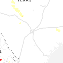
Texas
| Local Time | Report Details |
|---|---|
| 3:25 PM CDT | Quarter sized hail reported near Dalhart, TX, 53.6 miles NE of Tucumcari, NM, dime to quarter size hail with heavy rainfall. |
| 4:56 PM CDT | Abilene pd reported power lines down... power lines arcing and signal light debris on the roadway in abilen in taylor county TX, 0.9 miles SE of Abilene, TX |
| 4:56 PM CDT | Media reports broken tree limbs and a leaning power pole in abilen in taylor county TX, 0.6 miles S of Abilene, TX |
| 5:00 PM CDT | Storm damage reported in parmer county TX, 61.9 miles SW of Amarillo, TX |
| 5:05 PM CDT | Storm damage reported in parmer county TX, 61.9 miles SW of Amarillo, TX |
| 5:42 PM CDT | Storm damage reported in deaf smith county TX, 36.9 miles SW of Amarillo, TX |
| 5:45 PM CDT | Storm damage reported in hockley county TX, 21.5 miles WNW of Lubbock, TX |
| 5:58 PM CDT | Storm damage reported in hockley county TX, 21.5 miles WNW of Lubbock, TX |
| 6:15 PM CDT | Storm damage reported in lubbock county TX, 16.3 miles SW of Lubbock, TX |
| 6:27 PM CDT | Storm damage reported in randall county TX, 20.5 miles SW of Amarillo, TX |
| 6:35 PM CDT | Storm damage reported in hale county TX, 39.9 miles N of Lubbock, TX |
| 7:05 PM CDT | Storm damage reported in floyd county TX, 41.3 miles NE of Lubbock, TX |
| 7:09 PM CDT | Hen Egg sized hail reported near Tarzan, TX, 37.9 miles NNE of Odessa, TX, 1 1/2 to 2 inches |
| 7:15 PM CDT | Storm damage reported in floyd county TX, 41.3 miles NE of Lubbock, TX |
| 7:44 PM CDT | Storm damage reported in briscoe county TX, 48.5 miles W of Childress, TX |
| 8:10 PM CDT | Trees down and power lines down in howard county TX, 59.3 miles ENE of Odessa, TX |
| 8:37 PM CDT | Storm damage reported in childress county TX, 3.9 miles W of Childress, TX |
| 9:24 PM CDT | Blowing dust and 60 mph winds w/near zero visibility and traffic stopped on i2 in nolan county TX, 43.2 miles W of Abilene, TX |
| 9:40 PM CDT | Law enforcement reported 50-70 mph winds near highway 2034 and highway 15 in coke county TX, 62 miles SW of Abilene, TX |
Delaware
| Local Time | Report Details |
|---|---|
| 4:56 PM EDT | Report of power lines down in the millsboro area. time and location approximated from rada in sussex county DE, 21.1 miles NNW of Ocean City, MD |
New Mexico
| Local Time | Report Details |
|---|---|
| 3:06 PM MDT | Kcvs aso in curry county NM, 59.3 miles SSE of Tucumcari, NM |
| 3:15 PM MDT | Kcvs aso in curry county NM, 59.3 miles SSE of Tucumcari, NM |
| 3:33 PM MDT | Kcvn awo in curry county NM, 63.6 miles SE of Tucumcari, NM |
| 3:34 PM MDT | Quarter sized hail reported near Carlsbad, NM, 70.5 miles SSE of Roswell, NM, e40 to 45 mph winds |
| 4:50 PM MDT | Storm damage reported in lea county NM, 76.1 miles NW of Odessa, TX |
| 4:55 PM MDT | Storm damage reported in lea county NM, 81.5 miles NW of Odessa, TX |
| 4:57 PM MDT | Power pole downed by winds in central hobbs at the intersection of sanger and ship in lea county NM, 76.1 miles NW of Odessa, TX |
Tennessee
| Local Time | Report Details |
|---|---|
| 4:44 PM CDT | Tree down near intersection of west madison street and n. 8th street. minor roof damage from tre in giles county TN, 45.8 miles NE of Florence, AL |
Maryland
| Local Time | Report Details |
|---|---|
| 5:55 PM EDT | Tree down in a yard east of princess ann in somerset county MD, 32.5 miles WSW of Ocean City, MD |
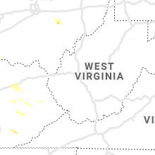
Kentucky
| Local Time | Report Details |
|---|---|
| 6:16 PM EDT | Hen Egg sized hail reported near Hazel Green, KY, 28.2 miles ENE of Irvine, KY, report on gosneyville rd. |
| 6:21 PM EDT | Golf Ball sized hail reported near Hazel Green, KY, 31.1 miles ENE of Irvine, KY, time of the event is radar estimated. |
| 6:23 PM EDT | Half Dollar sized hail reported near Hazel Green, KY, 35.1 miles E of Irvine, KY |
| 6:25 PM EDT | Golf Ball sized hail reported near Salt Lick, KY, 34.9 miles NNE of Irvine, KY |
| 6:29 PM EDT | 2 large trees down on stamper branch r in wolfe county KY, 31.1 miles ENE of Irvine, KY |
| 6:35 PM EDT | Tree down on highway 21 in bath county KY, 32.6 miles NE of Irvine, KY |
| 6:47 PM EDT | Storm damage reported in boone county KY, 9.2 miles WSW of Cincinnati, OH |
| 6:47 PM EDT | Quarter sized hail reported near Manchester, KY, 54 miles SSE of Irvine, KY |
| 6:52 PM EDT | Trees uprooted in boone county KY, 10.9 miles SW of Cincinnati, OH |
| 6:55 PM EDT | 6 inch diameter limbs downe in kenton county KY, 9 miles SSW of Cincinnati, OH |
| 6:57 PM EDT | Multiple trees down milton... k in trimble county KY, 53.3 miles NNE of Louisville, KY |
| 7:15 PM EDT | 10-15 trees down along 42 between connector rd and hwy 3 in trimble county KY, 50.4 miles NNE of Louisville, KY |
| 7:15 PM EDT | Tree down about 3 miles south of highway 71 in morgan county KY, 42.8 miles ENE of Irvine, KY |
| 7:27 PM EDT | One tree down. time estimated from radar dat in pendleton county KY, 30.6 miles SSE of Cincinnati, OH |
| 7:42 PM EDT | Trees down in bracken county KY, 35.8 miles SE of Cincinnati, OH |
| 7:46 PM EDT | Tree down on higway 30 west just past highland turner elementary schoo in breathitt county KY, 29.7 miles ESE of Irvine, KY |
| 7:55 PM EDT | Trees down along robinson-renaker r in harrison county KY, 43.7 miles S of Cincinnati, OH |
| 8:05 PM EDT | Tree down along commonwealt in harrison county KY, 47.8 miles SSE of Cincinnati, OH |
| 8:20 PM EDT | Tree down rosebay lan in harrison county KY, 49.6 miles NNW of Irvine, KY |
| 8:54 PM EDT | Trees down along creekview d in bourbon county KY, 38.7 miles NNW of Irvine, KY |
| 9:03 PM EDT | Large tree down on linden wal in fayette county KY, 37.1 miles NW of Irvine, KY |
| 9:54 PM EDT | Numerous trees down across the county including on main street... highway 519... and highway 19 in morgan county KY, 41.2 miles ENE of Irvine, KY |
| 9:13 PM CDT | Tree down on st mary church r in breckinridge county KY, 48.9 miles WSW of Louisville, KY |
| 9:15 PM CDT | Power lines down on 4th st in hardinsbur in breckinridge county KY, 43.1 miles WSW of Louisville, KY |
| 10:17 PM EDT | Tree down on a cabin near roger in wolfe county KY, 18.5 miles E of Irvine, KY |
| 9:59 PM CDT | Tree down on hwy 259 in breckinridge county KY, 47 miles WSW of Louisville, KY |
| 10:20 PM CDT | Tree damag in hart county KY, 48.9 miles S of Louisville, KY |
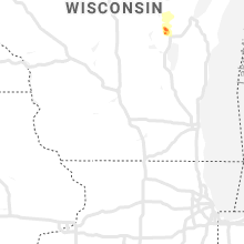
Wisconsin
| Local Time | Report Details |
|---|---|
| 5:38 PM CDT | Quarter sized hail reported near Shiocton, WI, 28.7 miles WSW of Green Bay, WI |
| 5:41 PM CDT | Quarter sized hail reported near Shiocton, WI, 29.4 miles WSW of Green Bay, WI |
| 5:53 PM CDT | Ping Pong Ball sized hail reported near Shiocton, WI, 29.2 miles WSW of Green Bay, WI, from social media |
| 5:53 PM CDT | Tennis Ball sized hail reported near Hortonville, WI, 30.1 miles WSW of Green Bay, WI, delayed report from social media. time estimated by radar. |
| 5:57 PM CDT | Tennis Ball sized hail reported near Hortonville, WI, 29.1 miles WSW of Green Bay, WI, delayed report from social media. time estimated by radar. |
Nebraska
| Local Time | Report Details |
|---|---|
| 6:21 PM CDT | Localized downburst from a collapsing tstm. this may be an overestimate. the anemometer in the tower was only gusting to around 35 k in hall county NE, 3.5 miles NNE of Grand Island, NE |
Kansas
| Local Time | Report Details |
|---|---|
| 6:45 PM CDT | Quarter sized hail reported near Goddard, KS, 13.5 miles W of Wichita, KS, social media picture of quarter sized hail in goddard... relayed via kwch. time was estimated. |
Oklahoma
| Local Time | Report Details |
|---|---|
| 9:55 PM CDT | Awos station kaxs altus quartz mt in jackson county OK, 53.6 miles ENE of Childress, TX |
Connect with Interactive Hail Maps