

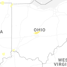
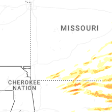
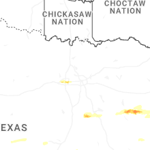
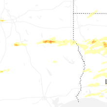
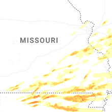
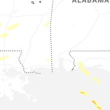
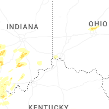
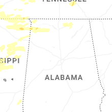
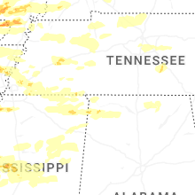
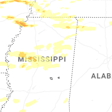
Hail Map for Sunday, March 30, 2025

Number of Impacted Households on 3/30/2025
0
Impacted by 1" or Larger Hail
0
Impacted by 1.75" or Larger Hail
0
Impacted by 2.5" or Larger Hail
Square Miles of Populated Area Impacted on 3/30/2025
0
Impacted by 1" or Larger Hail
0
Impacted by 1.75" or Larger Hail
0
Impacted by 2.5" or Larger Hail


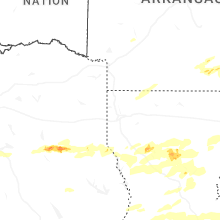
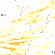
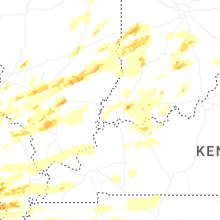
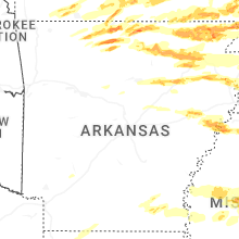

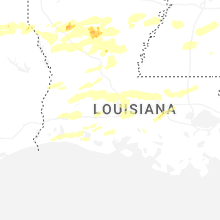
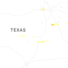
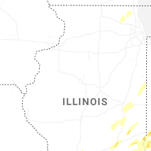
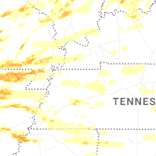
Cities Most Affected by Hail Storms of 3/30/2025
| Hail Size | Demographics of Zip Codes Affected | ||||||
|---|---|---|---|---|---|---|---|
| City | Count | Average | Largest | Pop Density | House Value | Income | Age |
| Jacksonville, TX | 4 | 2.00 | 2.50 | 87 | $52k | $28.3k | 34.8 |
| Fort Worth, TX | 3 | 1.75 | 1.75 | 3169 | $74k | $35.7k | 33.2 |
| Viola, AR | 2 | 2.25 | 2.75 | 16 | $57k | $29.1k | 41.5 |
| Kimberling City, MO | 2 | 2.13 | 2.50 | 537 | $118k | $37.3k | 58.8 |
| Marked Tree, AR | 2 | 2.13 | 2.50 | 57 | $54k | $23.7k | 41.4 |
| Piggott, AR | 2 | 1.75 | 1.75 | 49 | $51k | $26.8k | 43.9 |
| Bonne Terre, MO | 2 | 1.75 | 1.75 | 116 | $76k | $36.0k | 38.3 |
| Salem, IL | 2 | 1.75 | 1.75 | 111 | $62k | $36.6k | 40.5 |
| Bradford, AR | 1 | 3.00 | 3.00 | 20 | $38k | $27.8k | 42.4 |
| Salem, MO | 1 | 2.50 | 2.50 | 21 | $63k | $27.0k | 42.8 |
| Bunker, MO | 1 | 2.50 | 2.50 | 4 | $45k | $21.9k | 43.8 |
| Yukon, MO | 1 | 2.25 | 2.25 | 19 | $49k | $32.2k | 47.0 |
| Smyrna, TN | 1 | 2.00 | 2.00 | 894 | $116k | $48.0k | 33.9 |
| Henderson, TX | 1 | 2.00 | 2.00 | 60 | $65k | $32.4k | 37.6 |
| Winona, MO | 1 | 2.00 | 2.00 | 9 | $45k | $20.5k | 38.3 |
| Nolensville, TN | 1 | 2.00 | 2.00 | 289 | $170k | $63.8k | 36.2 |
| Corning, AR | 1 | 2.00 | 2.00 | 28 | $38k | $23.5k | 42.8 |
| Mount Enterprise, TX | 1 | 1.75 | 1.75 | 17 | $44k | $27.3k | 43.6 |
| Bloomsdale, MO | 1 | 1.75 | 1.75 | 43 | $94k | $41.3k | 39.9 |
| Perryville, MO | 1 | 1.75 | 1.75 | 48 | $81k | $36.7k | 38.6 |
| Mountain Home, AR | 1 | 1.75 | 1.75 | 133 | $87k | $29.7k | 50.4 |
| Yellville, AR | 1 | 1.75 | 1.75 | 16 | $70k | $26.0k | 48.3 |
| Myrtle, MO | 1 | 1.75 | 1.75 | 12 | $35k | $22.3k | 49.8 |
| Cave City, AR | 1 | 1.75 | 1.75 | 34 | $53k | $30.2k | 39.9 |
| Tunica, MS | 1 | 1.75 | 1.75 | 17 | $56k | $20.9k | 33.9 |
| Evansville, IL | 1 | 1.75 | 1.75 | 23 | $59k | $34.0k | 43.1 |
| Paragould, AR | 1 | 1.75 | 1.75 | 131 | $69k | $31.0k | 37.3 |
| Joiner, AR | 1 | 1.75 | 1.75 | 11 | $48k | $23.1k | 43.2 |
| Timpson, TX | 1 | 1.75 | 1.75 | 20 | $58k | $28.0k | 39.2 |
| Fremont, MO | 1 | 1.75 | 1.75 | 2 | $51k | $22.9k | 45.1 |
| Winnfield, LA | 1 | 1.75 | 1.75 | 26 | $46k | $24.1k | 38.7 |
| Centralia, IL | 1 | 1.75 | 1.75 | 155 | $53k | $34.0k | 41.1 |
| Lyons, IN | 1 | 1.75 | 1.75 | 17 | $49k | $30.0k | 43.6 |
| Gamaliel, AR | 1 | 1.75 | 1.75 | 27 | $68k | $25.3k | 55.2 |
| Strawberry, AR | 1 | 1.75 | 1.75 | 12 | $48k | $26.3k | 41.8 |
| Pinckneyville, IL | 1 | 1.75 | 1.75 | 43 | $62k | $35.7k | 37.8 |
| Fancy Farm, KY | 1 | 1.75 | 1.75 | 33 | $67k | $30.2k | 41.2 |
| Campti, LA | 1 | 1.75 | 1.75 | 40 | $52k | $21.5k | 36.9 |
| Tyronza, AR | 1 | 1.75 | 1.75 | 10 | $51k | $30.8k | 41.1 |
| Shell Knob, MO | 1 | 1.75 | 1.75 | 52 | $94k | $29.2k | 58.8 |
| Greenville, MO | 1 | 1.75 | 1.75 | 8 | $39k | $24.5k | 46.6 |
| Williamsville, MO | 1 | 1.75 | 1.75 | 16 | $49k | $27.8k | 46.2 |
| Coldwater, MS | 1 | 1.75 | 1.75 | 61 | $69k | $34.2k | 39.3 |
| Du Quoin, IL | 1 | 1.75 | 1.75 | 97 | $52k | $31.6k | 40.2 |
Hail and Wind Damage Spotted on 3/30/2025
Filter by Report Type:Hail ReportsWind Reports
States Impacted
Texas, Missouri, Illinois, Mississippi, Indiana, Arkansas, Michigan, Ohio, Kentucky, Tennessee, West Virginia, Virginia, LouisianaTexas
| Local Time | Report Details |
|---|---|
| 10:30 AM CDT | Quarter sized hail reported near Jarrell, TX, 22.4 miles SSE of Killeen, TX, time estimated off radar. |
| 12:18 PM CDT | Quarter sized hail reported near Bartlett, TX, 29.9 miles SE of Killeen, TX, report from mping. |
| 3:45 PM CDT | Half Dollar sized hail reported near Fort Worth, TX, 36.5 miles W of Dallas, TX, report from mping: half dollar (1.25 in.). |
| 3:48 PM CDT | Half Dollar sized hail reported near Fort Worth, TX, 35.9 miles W of Dallas, TX, report from mping: half dollar (1.25 in.). |
| 3:49 PM CDT | Half Dollar sized hail reported near Fort Worth, TX, 34.1 miles W of Dallas, TX, report from mping: half dollar (1.25 in.). |
| 4:05 PM CDT | Golf Ball sized hail reported near Fort Worth, TX, 25.4 miles W of Dallas, TX, golf ball size hail reported at e loop 820 and lancaster. |
| 4:09 PM CDT | Golf Ball sized hail reported near Fort Worth, TX, 23.6 miles W of Dallas, TX, golf ball size hail reported near i-30 and east loop 820. |
| 4:09 PM CDT | Golf Ball sized hail reported near Fort Worth, TX, 24.9 miles W of Dallas, TX, corrects previous hail report from 4 nw pantego. golf ball size hail reported near lancaster and east loop 820. |
| 4:16 PM CDT | Ping Pong Ball sized hail reported near Arlington, TX, 19.5 miles W of Dallas, TX, ping pong ball size hail reported near i-30 and fielder. |
| 4:16 PM CDT | Ping Pong Ball sized hail reported near Fort Worth, TX, 23.1 miles W of Dallas, TX, corrects previous hail report from 3 nne pantego. ping pong ball size hail reported on meadowbrook dr near i-30 and cooks. |
| 7:25 PM CDT | Golf Ball sized hail reported near Jacksonville, TX, 53.6 miles NW of Lufkin, TX, reports of hail up to golf ball size falling in the city of jacksonville. |
| 7:55 PM CDT | Tennis Ball sized hail reported near Jacksonville, TX, 44.3 miles NNW of Lufkin, TX, report from mping: tennis ball (2.50 in.) time estimated by radar. |
| 8:00 PM CDT | Hen Egg sized hail reported near Henderson, TX, 43.3 miles NNW of Lufkin, TX, social media report of at least 2 inch size hail just south of lake striker. |
| 8:00 PM CDT | Golf Ball sized hail reported near Jacksonville, TX, 43.9 miles NNW of Lufkin, TX, local media relaying public report of golf ball size hail in the ponta community. |
| 8:05 PM CDT | Quarter sized hail reported near Henderson, TX, 43.6 miles NNW of Lufkin, TX, reported at the new salem vfd... just east of lake striker. time estimated by radar. |
| 8:05 PM CDT | Hen Egg sized hail reported near Jacksonville, TX, 46 miles NNW of Lufkin, TX, approximately 3 miles west of lake striker. time estimated by radar. |
| 8:30 PM CDT | Golf Ball sized hail reported near Mount Enterprise, TX, 39.8 miles N of Lufkin, TX, reported west of mount enterprise along cr 3206. time estimated by radar. |
| 8:40 PM CDT | Quarter sized hail reported near Mount Enterprise, TX, 41.3 miles N of Lufkin, TX, reported just ne of mount enterprise along highway 315. time estimated by radar. |
| 9:50 PM CDT | Golf Ball sized hail reported near Timpson, TX, 43.4 miles NNE of Lufkin, TX, hail up to golf ball size reported in the town of timpson. |
| 9:57 PM CDT | Quarter sized hail reported near Nacogdoches, TX, 28.2 miles N of Lufkin, TX, report of a few hailstones up to the size of a quarter near the central heights community. time estimated by radar. |
| 10:04 PM CDT | Quarter sized hail reported near Nacogdoches, TX, 32.5 miles N of Lufkin, TX, quarter size hail reported between garrison and cushing. |
| 10:19 PM CDT | Quarter sized hail reported near Tenaha, TX, 49.3 miles SW of Shreveport, LA, hail reported at a convenience store in tenaha... texas. |
Missouri
| Local Time | Report Details |
|---|---|
| 5:12 PM UTC | Quarter sized hail reported near Plato, MO, 33.6 miles WSW of Salem, MO, mostly penny size with a few quarter size hail stones near roby. |
| 6:20 PM UTC | Half Dollar sized hail reported near Salem, MO, 8.2 miles NNE of Salem, MO, northeast of salem. |
| 1:34 PM CDT | Quarter sized hail reported near Dora, MO, 66.2 miles ESE of Springfield, MO, quarter size hail in dora area. |
| 6:40 PM UTC | Quarter sized hail reported near Steelville, MO, 24.1 miles ENE of Salem, MO |
| 7:00 PM UTC | Half Dollar sized hail reported near Pomona, MO, 56.8 miles SSW of Salem, MO |
| 2:02 PM CDT | Quarter sized hail reported near Houston, MO, 32 miles SW of Salem, MO, houston fire reported quarter size hail. |
| 2:04 PM CDT | Quarter sized hail reported near Potosi, MO, 45.9 miles ENE of Salem, MO, quarter to half dollar sized hail reported - lsring quarters based on radar trends. |
| 2:15 PM CDT | Hen Egg sized hail reported near Yukon, MO, 30.6 miles SW of Salem, MO |
| 2:22 PM CDT | Quarter sized hail reported near Portage Des Sioux, MO, 23.1 miles NW of Saint Louis, MO, pea to quarter size hail. picture on social media. |
| 2:27 PM CDT | Golf Ball sized hail reported near Bonne Terre, MO, 52.6 miles SSW of Saint Louis, MO |
| 2:29 PM CDT | Quarter sized hail reported near Bonne Terre, MO, 52.6 miles SSW of Saint Louis, MO, quarter sized hail in bonne terre. |
| 2:37 PM CDT | Golf Ball sized hail reported near Bonne Terre, MO, 52.6 miles SSW of Saint Louis, MO, relayed from pah: picture of estimated golf ball sized hail. |
| 2:42 PM CDT | Quarter sized hail reported near French Village, MO, 46.5 miles SSW of Saint Louis, MO, 5 minutes of quarter sized hail falling in french village. |
| 7:42 PM UTC | Quarter sized hail reported near Salem, MO, 0.3 miles NW of Salem, MO |
| 2:45 PM CDT | Tennis Ball sized hail reported near Salem, MO, 19.3 miles SSE of Salem, MO |
| 2:50 PM CDT | Quarter sized hail reported near Caledonia, MO, 42.8 miles ENE of Salem, MO, quarter or slightly larger sized hail in caledonia. |
| 2:53 PM CDT | Golf Ball sized hail reported near Bloomsdale, MO, 42.7 miles S of Saint Louis, MO |
| 2:56 PM CDT | Tennis Ball sized hail reported near Bunker, MO, 22 miles SE of Salem, MO |
| 2:58 PM CDT | Quarter sized hail reported near Bismarck, MO, 50.9 miles ENE of Salem, MO, quarter sized hail in bismarck. |
| 3:30 PM CDT | Quarter sized hail reported near Theodosia, MO, 54.8 miles SE of Springfield, MO |
| 3:34 PM CDT | Quarter sized hail reported near Theodosia, MO, 55.7 miles SE of Springfield, MO, approximate 1 inch hail in theodosia area. |
| 8:40 PM UTC | Quarter sized hail reported near Isabella, MO, 57.2 miles SE of Springfield, MO, quarter size hail northeast of theodosia. |
| 3:50 PM CDT | Golf Ball sized hail reported near Shell Knob, MO, 44.3 miles SSW of Springfield, MO, golf ball size hail hwy yy and county line road. |
| 3:58 PM CDT | Tennis Ball sized hail reported near Kimberling City, MO, 39.9 miles S of Springfield, MO, 2.5 inch hail in kimberling city area. |
| 3:58 PM CDT | Hen Egg sized hail reported near Winona, MO, 44.8 miles SSE of Salem, MO, approximately 2 inch hail winona area. |
| 4:02 PM CDT | Golf Ball sized hail reported near Kimberling City, MO, 40 miles S of Springfield, MO, golf ball size hail in kimberling city. |
| 9:05 PM UTC | Quarter sized hail reported near Thayer, MO, 76.3 miles S of Salem, MO, reported in thayer. |
| 4:05 PM CDT | Quarter sized hail reported near Mountain Grove, MO, 54.8 miles SW of Salem, MO |
| 4:10 PM CDT | Quarter sized hail reported near Cabool, MO, 48.2 miles SW of Salem, MO, quarter size hail 2 miles west cabool. |
| 4:15 PM CDT | Golf Ball sized hail reported near Fremont, MO, 51.3 miles SSE of Salem, MO, slightly larger than golf ball size hail. |
| 4:23 PM CDT | Quarter sized hail reported near Van Buren, MO, 48.5 miles SSE of Salem, MO, reported on m hwy... 4 miles north of van buren. |
| 4:23 PM CDT | Quarter sized hail reported near Ava, MO, 37 miles ESE of Springfield, MO, quarter size hail 5 n ava. |
| 4:25 PM CDT | Half Dollar sized hail reported near Mountain Grove, MO, 54.8 miles SW of Salem, MO, report from mping half dollar 1.25 in. |
| 4:28 PM CDT | Golf Ball sized hail reported near Williamsville, MO, 59.8 miles WSW of Cape Girardeau, MO |
| 4:29 PM CDT | Golf Ball sized hail reported near Myrtle, MO, 79.1 miles S of Salem, MO, approximate golf ball size hail in myrtle area. |
| 4:42 PM CDT | Half Dollar sized hail reported near Wasola, MO, 48.4 miles SE of Springfield, MO, hail in between quarter and ping pong ball size fell on county road 851. time estimated via radar. |
| 4:44 PM CDT | Golf Ball sized hail reported near Perryville, MO, 28.2 miles NNW of Cape Girardeau, MO |
| 4:45 PM CDT | Ping Pong Ball sized hail reported near Frohna, MO, 29.1 miles NNW of Cape Girardeau, MO |
| 4:49 PM CDT | Quarter sized hail reported near Perryville, MO, 28.2 miles NNW of Cape Girardeau, MO |
| 4:52 PM CDT | Quarter sized hail reported near Greenville, MO, 51.3 miles WSW of Cape Girardeau, MO |
| 4:52 PM CDT | Golf Ball sized hail reported near Greenville, MO, 51.3 miles WSW of Cape Girardeau, MO |
| 10:06 PM UTC | Half Dollar sized hail reported near Dora, MO, 65.6 miles ESE of Springfield, MO, hail up to half dollar size just north of dora. |
| 5:33 PM CDT | Quarter sized hail reported near Qulin, MO, 62.2 miles SW of Cape Girardeau, MO |
| 5:35 PM CDT | Quarter sized hail reported near West Plains, MO, 53.3 miles SSW of Salem, MO, quarter size hail in peace valley area. |
| 5:48 PM CDT | Small branches broke in stoddard county MO, 35.5 miles SW of Cape Girardeau, MO |
| 5:48 PM CDT | Quarter sized hail reported near Birch Tree, MO, 52.2 miles S of Salem, MO, quarter size hail between birch tree and thomasville. |
| 5:51 PM CDT | Quarter sized hail reported near Dexter, MO, 41.6 miles SSW of Cape Girardeau, MO |
| 5:58 PM CDT | Ping Pong Ball sized hail reported near Bernie, MO, 49.8 miles SSW of Cape Girardeau, MO, report from mping: ping pong ball (1.50 in.). |
| 6:03 PM CDT | Ping Pong Ball sized hail reported near Bernie, MO, 49.6 miles SSW of Cape Girardeau, MO, report from mping: ping pong ball (1.50 in.). |
| 6:03 PM CDT | Ping Pong Ball sized hail reported near Dudley, MO, 48.7 miles SW of Cape Girardeau, MO, report from mping: ping pong ball (1.50 in.). |
| 6:19 PM CDT | Quarter sized hail reported near Malden, MO, 56.4 miles SSW of Cape Girardeau, MO, report of hail the size of quarters near malden. |
| 6:57 PM CDT | Half Dollar sized hail reported near East Prairie, MO, 35.5 miles SSE of Cape Girardeau, MO, report from mping: half dollar (1.25 in.). |
| 7:15 PM CDT | Storm damage reported in mississippi county MO, 47.6 miles SSE of Cape Girardeau, MO |
| 7:43 PM CDT | Quarter sized hail reported near Portageville, MO, 56.9 miles S of Cape Girardeau, MO, report from mping: quarter (1.00 in.). |
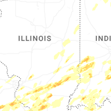
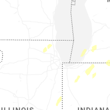
Illinois
| Local Time | Report Details |
|---|---|
| 12:16 PM CDT | Doors of a farm outbuilding blown in and camper blown on its side. pictures from slac in clinton county IL, 36.3 miles E of Saint Louis, MO |
| 1:07 PM CDT | Downs trees and power lines and poles in sullivan via facebook pos in moultrie county IL, 14.9 miles WNW of Mattoon, IL |
| 1:17 PM CDT | Photos of power poles down northwest of mattoon on near highway 3 in coles county IL, 1.8 miles NW of Mattoon, IL |
| 1:30 PM CDT | Storage unit damaged on county road 900 just east of highway 45 1.5 miles nne of tolon in champaign county IL, 37.1 miles N of Mattoon, IL |
| 1:30 PM CDT | Morton building collapsed at 1083 caty road 900 n 1.5 miles nne of tolono. photos sen in champaign county IL, 37.1 miles N of Mattoon, IL |
| 1:30 PM CDT | Building collapsed from high wind in champaign county IL, 35.6 miles N of Mattoon, IL |
| 1:33 PM CDT | Kane county ema reports fence damage along muirhead road west of elgin. time estimated by rada in kane county IL, 41.5 miles WNW of Chicago, IL |
| 1:35 PM CDT | Ping Pong Ball sized hail reported near Columbia, IL, 12.3 miles S of Saint Louis, MO, largest hail between 1 and 1.5 inches in diameter. |
| 1:35 PM CDT | Asos station kcmi willard arpt station elevation: 742 f in champaign county IL, 38.2 miles N of Mattoon, IL |
| 1:35 PM CDT | Several power poles and lines blown down west of 2.5 miles west of charlesto in coles county IL, 7.8 miles E of Mattoon, IL |
| 1:35 PM CDT | Pine tree broke off from high winds and landed on a ca in champaign county IL, 40.5 miles N of Mattoon, IL |
| 1:35 PM CDT | 3 car crashes on southbound i-57 at mile marker 229 from high wind in champaign county IL, 37.3 miles N of Mattoon, IL |
| 1:36 PM CDT | Quarter sized hail reported near Columbia, IL, 12.3 miles S of Saint Louis, MO, quarter sized hail in columbia. |
| 1:37 PM CDT | Kane county ema reports tree blocking eastbound lanes of highland avenue at coombs road west of elgin. time estimated by rada in kane county IL, 40.4 miles WNW of Chicago, IL |
| 1:39 PM CDT | Ping Pong Ball sized hail reported near Columbia, IL, 12.3 miles S of Saint Louis, MO, public report 1.5 ne of columbia proper. |
| 1:40 PM CDT | Mesonet station fw0668 urbana station elevation: 748 f in champaign county IL, 42.5 miles NNE of Mattoon, IL |
| 1:40 PM CDT | Quarter sized hail reported near Effingham, IL, 26.4 miles SSW of Mattoon, IL |
| 1:42 PM CDT | Quarter sized hail reported near Millstadt, IL, 9.8 miles SSE of Saint Louis, MO, report from mping: quarter (1.00 in.). |
| 1:43 PM CDT | Photo shows evergreen tree uprooted near sleepy hollow. relayed by broadcast media... time estimated by rada in kane county IL, 37.7 miles WNW of Chicago, IL |
| 1:45 PM CDT | At least 8-9 power poles blown down near roya in champaign county IL, 53.4 miles NNE of Mattoon, IL |
| 1:45 PM CDT | Power outages from high thunderstorm wind gust in champaign county IL, 46.9 miles NNE of Mattoon, IL |
| 1:45 PM CDT | Some structural damage from high winds along with power outage in champaign county IL, 40.6 miles NNE of Mattoon, IL |
| 1:45 PM CDT | Quarter sized hail reported near Ashmore, IL, 19.3 miles E of Mattoon, IL, photo sent with 1 inch hail next to a quarter. hail lasted for about 15 minutes and ponding of water. |
| 1:46 PM CDT | Kane county ema reports broken tree branch on power lines near fremont street and hill avenue in elgin. time estimated by rada in kane county IL, 34.8 miles WNW of Chicago, IL |
| 1:46 PM CDT | Kane county ema reports power lines downed along arrow street and austin avenue in carpentersville. time estimated by rada in kane county IL, 36.5 miles WNW of Chicago, IL |
| 1:49 PM CDT | Quarter sized hail reported near Belleville, IL, 11 miles SE of Saint Louis, MO, hail ranging in size from dimes to quarters fell for nearly 6 mins. |
| 1:50 PM CDT | Storm damage reported in champaign county IL, 48.7 miles NNE of Mattoon, IL |
| 1:50 PM CDT | Power outages in homer from high wind in champaign county IL, 44.4 miles NNE of Mattoon, IL |
| 1:58 PM CDT | Private weather station kilgilma8 reported 66 mph gust southwest of crescent cit in iroquois county IL, 80.2 miles S of Chicago, IL |
| 2:00 PM CDT | House roof damage from strong winds on e 2430 north roa in vermilion county IL, 61.2 miles NE of Mattoon, IL |
| 2:05 PM CDT | Measured wind gusts from 70 to 85 mph. unofficial nearby report of 105 mph wind gus in vermilion county IL, 75.6 miles NNE of Mattoon, IL |
| 2:05 PM CDT | Tree blown down on a house near denmark rd and west newell r in vermilion county IL, 62.7 miles NE of Mattoon, IL |
| 2:07 PM CDT | Storm damage reported in vermilion county IL, 72.7 miles NNE of Mattoon, IL |
| 2:07 PM CDT | Tree branches blown down on power lines. about 25 percent of hoopeston without powe in vermilion county IL, 77.8 miles NNE of Mattoon, IL |
| 2:07 PM CDT | Wind gust of 62 mph with damage to chicken coop fence. wind snapped old cedar posts of in vermilion county IL, 65.5 miles NE of Mattoon, IL |
| 2:08 PM CDT | Damage shed from strong winds in bismarck. facebook repor in vermilion county IL, 67.4 miles NE of Mattoon, IL |
| 2:09 PM CDT | 70 mph winds at route 1 near the iroquois and vermilion county border with nickel hai in vermilion county IL, 78.2 miles NNE of Mattoon, IL |
| 2:10 PM CDT | Garage destroyed in danville near fairchild and griffin street in vermilion county IL, 60.3 miles NE of Mattoon, IL |
| 2:10 PM CDT | Damge to out building 0.5 mile ne of vermilion regional airport at 2400 north rd and 1950 east rd. photo provide in vermilion county IL, 64.5 miles NE of Mattoon, IL |
| 2:15 PM CDT | Indiana sign along route 9 near the indiana border damaged along with a farm she in vermilion county IL, 80.8 miles NNE of Mattoon, IL |
| 2:17 PM CDT | Private weather station reported 60 mph gust southeast of beavervill in iroquois county IL, 65.2 miles S of Chicago, IL |
| 2:22 PM CDT | Quarter sized hail reported near Red Bud, IL, 29.3 miles SSE of Saint Louis, MO, report from mping: quarter (1.00 in.). |
| 2:24 PM CDT | Private weather station reported 62 mph gust southeast of momenc in kankakee county IL, 51.4 miles S of Chicago, IL |
| 2:31 PM CDT | Ping Pong Ball sized hail reported near New Athens, IL, 29 miles SE of Saint Louis, MO, slack post of ping pong ball sized hail. |
| 2:31 PM CDT | 1.5 inch diameter tree branch broken near chadbourn drive and 88th avenue in orland hills. time estimated by rada in cook county IL, 22.7 miles SSW of Chicago, IL |
| 2:34 PM CDT | Ping Pong Ball sized hail reported near New Athens, IL, 28.8 miles SE of Saint Louis, MO, report east of new athens. |
| 2:39 PM CDT | Roof blown off building near sauk trail and holeman avenue in steger. time estimated by rada in cook county IL, 27.9 miles S of Chicago, IL |
| 2:40 PM CDT | Public report of small tree branches downed near 12th place and parnell avenue in west pullman community area of chicago. time estimated by rada in cook county IL, 14.8 miles S of Chicago, IL |
| 2:44 PM CDT | A few scattered reports of tree branches downed in the east side... calumet heights... roseland... burnside... pullman... south deering... and riverdale community areas in cook county IL, 12.3 miles SSE of Chicago, IL |
| 2:45 PM CDT | Private weather station reported reported 74 mph gust near ford height in cook county IL, 25.4 miles S of Chicago, IL |
| 2:45 PM CDT | 9 power poles broken and blown dow in clark county IL, 20.1 miles E of Mattoon, IL |
| 2:53 PM CDT | Golf Ball sized hail reported near Salem, IL, 64.3 miles SSW of Mattoon, IL, picture of estimated golf ball sized hail east of salem. |
| 2:53 PM CDT | Quarter sized hail reported near Addieville, IL, 41.8 miles ESE of Saint Louis, MO, photos of hailstones compared to a quarter as well as wind driven hail damage to siding of a buiding. siding has multiple quarter sized holes. |
| 3:00 PM CDT | Quarter sized hail reported near Nashville, IL, 45.9 miles ESE of Saint Louis, MO, broke siding. |
| 3:14 PM CDT | Golf Ball sized hail reported near Evansville, IL, 39.7 miles SSE of Saint Louis, MO, report of golf balls falling in evansville. |
| 3:17 PM CDT | Large tree limb down. time estimated from rada in marion county IL, 58.3 miles E of Saint Louis, MO |
| 3:19 PM CDT | Quarter sized hail reported near Centralia, IL, 58.2 miles E of Saint Louis, MO |
| 3:19 PM CDT | Golf Ball sized hail reported near Centralia, IL, 58.4 miles E of Saint Louis, MO, report from social media. |
| 3:31 PM CDT | Golf Ball sized hail reported near Salem, IL, 68.7 miles SSW of Mattoon, IL, quarter to golf ball sized hail south and east of salem il. |
| 3:34 PM CDT | Quarter sized hail reported near Kell, IL, 68.5 miles E of Saint Louis, MO, via twitter. |
| 3:35 PM CDT | Quarter sized hail reported near Flora, IL, 56.3 miles S of Mattoon, IL, photo from facebook of large hail in flora. |
| 3:36 PM CDT | Half Dollar sized hail reported near Nashville, IL, 48.7 miles ESE of Saint Louis, MO, via slack with picture of stones next to ruler - measured half dollar sized hail. |
| 3:45 PM CDT | Quarter sized hail reported near Clay City, IL, 54.6 miles S of Mattoon, IL |
| 3:47 PM CDT | Quarter sized hail reported near Ava, IL, 38.7 miles N of Cape Girardeau, MO |
| 3:49 PM CDT | Golf Ball sized hail reported near Pinckneyville, IL, 52 miles SE of Saint Louis, MO |
| 3:55 PM CDT | Tree blown down along with pea size hai in richland county IL, 52.1 miles SSE of Mattoon, IL |
| 4:00 PM CDT | Ping Pong Ball sized hail reported near Sesser, IL, 59.6 miles NNE of Cape Girardeau, MO |
| 4:00 PM CDT | Golf Ball sized hail reported near Du Quoin, IL, 50.3 miles NNE of Cape Girardeau, MO, golf ball size hail lasted 8 minutes. |
| 4:03 PM CDT | Ping Pong Ball sized hail reported near Flora, IL, 57.7 miles S of Mattoon, IL, ping pong size hail south of flora with photos. |
| 4:05 PM CDT | Quarter sized hail reported near Dundas, IL, 49.1 miles SSE of Mattoon, IL |
| 4:08 PM CDT | Quarter sized hail reported near Mount Vernon, IL, 72.5 miles ESE of Saint Louis, MO, hail fell for about 5 minutes and nearly covered the ground. |
| 4:09 PM CDT | Quarter sized hail reported near Vergennes, IL, 44.2 miles NNE of Cape Girardeau, MO |
| 4:20 PM CDT | Half Dollar sized hail reported near Du Quoin, IL, 51.6 miles NNE of Cape Girardeau, MO |
| 4:20 PM CDT | A few powerlines blown down in robinson along with pea size hai in crawford county IL, 47.1 miles SE of Mattoon, IL |
| 4:27 PM CDT | Half Dollar sized hail reported near Sesser, IL, 60.7 miles NNE of Cape Girardeau, MO, report from mping: half dollar (1.25 in.). |
| 4:51 PM CDT | Asos station klwv lawrenceville ap station elevation: 430 f in lawrence county IL, 54 miles N of Evansville, IN |
| 5:11 PM CDT | Ping Pong Ball sized hail reported near Mulkeytown, IL, 51.4 miles NNE of Cape Girardeau, MO |
| 5:38 PM CDT | Ping Pong Ball sized hail reported near Hurst, IL, 43.2 miles NNE of Cape Girardeau, MO |
| 6:30 PM CDT | Power poles snappe in pulaski county IL, 26.2 miles ESE of Cape Girardeau, MO |
| 6:30 PM CDT | Damage to high school roo in pulaski county IL, 24.6 miles E of Cape Girardeau, MO |
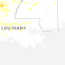
Mississippi
| Local Time | Report Details |
|---|---|
| 1:37 PM CDT | Em reports mobile home damaged on school land rd south of jim ramsay rd. likely tornad in jackson county MS, 45 miles WSW of Mobile, AL |
| 11:01 PM CDT | A few power poles down on old hwy 61 near bowdr in tunica county MS, 28.9 miles SSW of Memphis, TN |
| 11:22 PM CDT | Golf Ball sized hail reported near Tunica, MS, 36.3 miles SSW of Memphis, TN |
| 11:43 PM CDT | Golf Ball sized hail reported near Coldwater, MS, 31.3 miles S of Memphis, TN |
| 12:14 AM CDT | Quarter sized hail reported near Tiplersville, MS, 67 miles ESE of Memphis, TN |
| 1:45 AM CDT | Ping Pong Ball sized hail reported near Rienzi, MS, 50.3 miles W of Florence, AL, ping pong ball sized hail just off highway 45 near rienzi. |
| 1:47 AM CDT | Quarter sized hail reported near Burnsville, MS, 36.1 miles W of Florence, AL |
| 1:58 AM CDT | Quarter sized hail reported near Booneville, MS, 55 miles WSW of Florence, AL, quarter sized hail in the blackland area. |
| 2:01 AM CDT | Quarter sized hail reported near Booneville, MS, 51.8 miles W of Florence, AL |
| 3:48 AM CDT | Quarter sized hail reported near Greenwood, MS, 79.9 miles W of Starkville, MS, occurred along whaley rd near money. strong wind also reported. |
| 5:41 AM CDT | Estimated by nws employees. asos wind sensor failed during highest win in rankin county MS, 6.1 miles ENE of Jackson, MS |
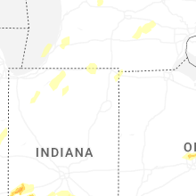
Indiana
| Local Time | Report Details |
|---|---|
| 3:26 PM EDT | Trees dow in vermillion county IN, 63 miles NE of Mattoon, IL |
| 3:26 PM EDT | Photo shows metal roof panels peeled from farm outbuilding at benton county fairgrounds. time estimated by rada in benton county IN, 82.9 miles NW of Indianapolis, IN |
| 7:26 PM UTC | Davis weather statio in benton county IN, 84.7 miles NW of Indianapolis, IN |
| 3:27 PM EDT | Private weather station reported 59 mph gust between boswell and oxfor in benton county IN, 80.4 miles NW of Indianapolis, IN |
| 2:29 PM CDT | Private weather station reported 59 mph gust near broo in newton county IN, 70.3 miles S of Chicago, IL |
| 3:30 PM EDT | Benton county ema reports semi tipped over on in-55 north of fowler. time estimated by radar... location approximat in benton county IN, 86.7 miles S of Chicago, IL |
| 3:30 PM EDT | Corrects previous report from 2 n fowler. benton county ema reports semi tipped over on in-55 north of fowler near 600n road. time estimated by radar... location approx in benton county IN, 84 miles S of Chicago, IL |
| 3:30 PM EDT | Utility lines were blown down. time estimated from rada in vermillion county IN, 65.6 miles NE of Mattoon, IL |
| 3:35 PM EDT | Private weather station reported 62 mph gust east of fowle in benton county IN, 82.1 miles NW of Indianapolis, IN |
| 2:36 PM CDT | Trained spotter reports numerous trees uprooted and branches broken along in-55 north of in-10. time estimated by radar... location approximat in newton county IN, 53 miles SSE of Chicago, IL |
| 2:37 PM CDT | Trained spotter reports 12 inch diameter tree downed near county 400 e and county 1200 n. time estimated by rada in newton county IN, 52 miles SSE of Chicago, IL |
| 2:38 PM CDT | Private weather station reported 63 mph gust north of remingto in jasper county IN, 79.2 miles SSE of Chicago, IL |
| 2:38 PM CDT | Trained spotter reports bent power poles in roselawn along in-10 3 miles east of in-55. time estimated by radar... location approximat in newton county IN, 54.5 miles SSE of Chicago, IL |
| 2:39 PM CDT | Lake county ema reports power poles snapped in lowell. time estimated by radar... location approximat in lake county IN, 42.5 miles SSE of Chicago, IL |
| 2:39 PM CDT | Private weather station reported 62 mph gust in remington. multiple other private weather stations reported gusts 55-60 mph in vicinit in jasper county IN, 81.4 miles SSE of Chicago, IL |
| 3:40 PM EDT | Large tree branches down onto house...no apparent damage. damage to barn doors. time estimated from rada in tippecanoe county IN, 45.4 miles NW of Indianapolis, IN |
| 2:45 PM CDT | Photo shows construction trailer overturned and broken into pieces along in-2 near clay street east of lowell. time estimated by rada in lake county IN, 44.9 miles SSE of Chicago, IL |
| 3:45 PM EDT | Time estimated from radar. southwest corner of purdue university there are branches up to inch in diameter blown down by thunderstorm wind in tippecanoe county IN, 61.3 miles NW of Indianapolis, IN |
| 2:46 PM CDT | Measured at davis station wwt in porter county IN, 45.2 miles SSE of Chicago, IL |
| 7:48 PM UTC | Davis station measuremen in jasper county IN, 71 miles SSE of Chicago, IL |
| 2:48 PM CDT | Lake county ema reports power poles snapped in dyer. time estimated by radar... location approximat in lake county IN, 27.8 miles SSE of Chicago, IL |
| 2:50 PM CDT | Lake county ema reports tree or large branch on house in highland. time estimated by radar... location approximat in lake county IN, 24.9 miles SSE of Chicago, IL |
| 2:50 PM CDT | Lake county ema reports power poles snapped in hammond. time estimated by radar... location approximat in lake county IN, 19.9 miles SSE of Chicago, IL |
| 3:50 PM EDT | Considerable siding off a home. time estimated from rada in tippecanoe county IN, 51.9 miles NW of Indianapolis, IN |
| 2:50 PM CDT | Private weather station reported 71 mph gust between goodland and remingto in jasper county IN, 79.2 miles SSE of Chicago, IL |
| 2:50 PM CDT | Report of several trees down some over 2 inches in diameter. time estimated from rada in lake county IN, 22.2 miles SSE of Chicago, IL |
| 7:51 PM UTC | Davis statio in jasper county IN, 69.7 miles SSE of Chicago, IL |
| 2:51 PM CDT | Private weather station reported 60 mph gust in munste in lake county IN, 24.7 miles SSE of Chicago, IL |
| 3:51 PM EDT | Trees dow in montgomery county IN, 48.5 miles W of Indianapolis, IN |
| 2:51 PM CDT | Photo shows shingle damage to house in latitude subdivision west of lake of the four seasons in winfield. time estimated by rada in lake county IN, 38.2 miles SSE of Chicago, IL |
| 2:52 PM CDT | Tree branches broken and barn damaged near in-2 and county 350s road. time estimated by rada in porter county IN, 41.4 miles SSE of Chicago, IL |
| 2:53 PM CDT | Lake county ema reports power poles snapped in east chicago. time estimated by radar... location approximat in lake county IN, 18.8 miles SSE of Chicago, IL |
| 2:53 PM CDT | Trained spotter reports 4 power poles snapped and downed power lines near boone grove high school southwest of valparaiso. time estimated by rada in porter county IN, 41.4 miles SE of Chicago, IL |
| 2:53 PM CDT | Trained spotter reports large branches broken near county 300s road and county 500w road southwest of valparaiso. time estimated by rada in porter county IN, 42 miles SE of Chicago, IL |
| 3:53 PM EDT | Tree dow in montgomery county IN, 42.8 miles WNW of Indianapolis, IN |
| 2:53 PM CDT | Public report of shingle damage near lake of the four seasons. time estimated by rada in porter county IN, 38.5 miles SSE of Chicago, IL |
| 2:53 PM CDT | Wxflow station cline avenue bridg in lake county IN, 18.2 miles SSE of Chicago, IL |
| 2:55 PM CDT | Gary airport gyy reported 74 mph gust. winds sustained at 48 mph for 10 minute in lake county IN, 21.5 miles SSE of Chicago, IL |
| 2:55 PM CDT | Lake county ema reports power poles snapped in gary. time estimated by radar... location approximat in lake county IN, 25 miles SE of Chicago, IL |
| 2:55 PM CDT | Power lines downed in kouts. time estimated by radar... location approximat in porter county IN, 49.9 miles SE of Chicago, IL |
| 2:55 PM CDT | Corrects previous report from 2 wnw rensselaer. rensselaer jasper county airport rzl awos reported 59 mph gus in jasper county IN, 68.6 miles SSE of Chicago, IL |
| 2:56 PM CDT | Private weather station reported 75 mph gust northeast of winfiel in porter county IN, 36.5 miles SE of Chicago, IL |
| 2:56 PM CDT | Photo shows metal roof panels peeled from farm outbuilding along county 75e road south of valparaiso. time estimated by rada in porter county IN, 44.5 miles SE of Chicago, IL |
| 3:59 PM EDT | Siding damaged by thunderstorm wind gust in tippecanoe county IN, 51.5 miles NW of Indianapolis, IN |
| 3:00 PM CDT | Trained weather spotter reported 63 mph gust on handheld anemometer on county 1200s southeast of kouts. time estimated by rada in porter county IN, 54.1 miles SE of Chicago, IL |
| 4:00 PM EDT | Three trees blown down by thunderstorm winds measured at 70 mph by an anemometer at the sit in tippecanoe county IN, 58.1 miles NW of Indianapolis, IN |
| 3:00 PM CDT | Trained spotter reported 80 mph gust in valparais in porter county IN, 40.8 miles SE of Chicago, IL |
| 4:00 PM EDT | Three trees blown down by thunderstorm winds measured at 70 mph by an anemometer at the sit in tippecanoe county IN, 58.1 miles NW of Indianapolis, IN |
| 3:00 PM CDT | *** 1 fatal *** a semi truck rolled onto a person... leading to a fatalit in porter county IN, 44.1 miles SE of Chicago, IL |
| 3:00 PM CDT | Valparaiso porter county airport vpz awos reported 81 mph gust prior to data outag in porter county IN, 44.4 miles SE of Chicago, IL |
| 4:00 PM EDT | Large tree snape in half 10 feet up. also 3 12 foot diameter trees snapped at bas in white county IN, 78.4 miles NNW of Indianapolis, IN |
| 3:01 PM CDT | Public report of broken tree branches in northern valparaiso. time estimated by rada in porter county IN, 40.6 miles SE of Chicago, IL |
| 4:01 PM EDT | Storm damage reported in carroll county IN, 59.7 miles NNW of Indianapolis, IN |
| 3:02 PM CDT | Private weather station reported 64 mph gust southeast of kout in porter county IN, 56.3 miles SE of Chicago, IL |
| 3:04 PM CDT | Private weather station kinkouts6 reported 70 mph gust north of kout in porter county IN, 49.2 miles SE of Chicago, IL |
| 3:04 PM CDT | Trained spotter reported multiple 6 inch diameter branches broken along us-6 between porter and valparaiso. time estimated by radar... location approximat in porter county IN, 35.5 miles SE of Chicago, IL |
| 3:07 PM CDT | Lines down across highway 42 in la porte county IN, 44 miles ESE of Chicago, IL |
| 3:10 PM CDT | Power lines down across 42 in la porte county IN, 50.5 miles SE of Chicago, IL |
| 4:10 PM EDT | Storm damage reported in vigo county IN, 57 miles E of Mattoon, IL |
| 3:11 PM CDT | Large sections of roofing material blown off st peter lutheran churc in starke county IN, 63.3 miles SE of Chicago, IL |
| 4:13 PM EDT | Delayed report...top edge of brick facade on front of a building extending above the roof line was damage in clinton county IN, 40.2 miles NW of Indianapolis, IN |
| 4:14 PM EDT | Structural damage to a barn at 2450 e 475 s. roof and siding blown off and strewn across road/field. large limbs also downed. time estimated based on rada in cass county IN, 68.7 miles N of Indianapolis, IN |
| 4:14 PM EDT | Trees downed on holland street and water s in cass county IN, 69.6 miles N of Indianapolis, IN |
| 4:14 PM EDT | Multiple trees down on us 3 in cass county IN, 72.2 miles WSW of Fort Wayne, IN |
| 4:14 PM EDT | Downed power line in cass county IN, 67 miles NNW of Indianapolis, IN |
| 4:14 PM EDT | Tree into a house on ridgeview way. no information on the tree size/healt in cass county IN, 69.3 miles NNW of Indianapolis, IN |
| 3:15 PM CDT | Several big tree branches are down and this one fell on a house on avondale ave in trail cree in la porte county IN, 41.9 miles ESE of Chicago, IL |
| 3:15 PM CDT | Tree downed across the road... large limbs downe in la porte county IN, 43.5 miles ESE of Chicago, IL |
| 4:15 PM EDT | Trees down on us 24 near georgetow in cass county IN, 71.6 miles NNW of Indianapolis, IN |
| 4:15 PM EDT | There are numerous reports of tree damage and several reports of structural damage around cass county... in. structural damage includes fencing downed and siding blown in cass county IN, 68.3 miles W of Fort Wayne, IN |
| 3:15 PM CDT | 400 block of laurel drive has trees on top of houses (houses still habitable). numerous reports of trees and powerlines down in this area and around michigan city. time in la porte county IN, 42.6 miles ESE of Chicago, IL |
| 3:17 PM CDT | Several trees reported down in la port in la porte county IN, 50.8 miles ESE of Chicago, IL |
| 3:19 PM CDT | Numerous reports of damage... including trees downed and roof blow off. metal siding is hanging from power lines in one video... damage to silo. power is ou in la porte county IN, 56.6 miles ESE of Chicago, IL |
| 3:20 PM CDT | Trees downed in michigan city with estimated wind gust of 60 mph. there are power outages. a large branch was reported downed on maple stree in la porte county IN, 39.7 miles ESE of Chicago, IL |
| 3:20 PM CDT | Trees downed in michigan city with estimated wind gust of 60 mph. there are power outages. a large branch was reported downed on maple stree in lmz046 county IN, 38.8 miles ESE of Chicago, IL |
| 8:22 PM UTC | Barn roof blew off and was temporarily blocking road at e state rd 4 and sr 104. time estimated by rada in la porte county IN, 57.1 miles ESE of Chicago, IL |
| 3:24 PM CDT | Measured at the michigan city glerl sit in lmz745 county IN, 37.3 miles ESE of Chicago, IL |
| 3:25 PM CDT | Numerous trees and powerlines downed across the area of fish lake. debris on the roads... some trees in houses. there are several large uprooted trees. there are severa in la porte county IN, 60 miles ESE of Chicago, IL |
| 4:25 PM EDT | Numerous reports of trees and powerlines down across the county (location varies). per radar the time of most reports in county were likely between 4:00 pm and 4:40 pm in fulton county IN, 57.5 miles W of Fort Wayne, IN |
| 4:27 PM EDT | Two poles down and in road near intersection of sr 10 and sr 1 in marshall county IN, 70.2 miles W of Fort Wayne, IN |
| 4:28 PM EDT | Trees down and a 58 mph gust was also measured in an anemometer. time estimated by rada in fulton county IN, 59.7 miles W of Fort Wayne, IN |
| 4:29 PM EDT | 5 foot radio tower blown down at fulton co. indiana ema building about 10 minutes ago due to high winds. location just east of the junction of state rd 25 and state rd in fulton county IN, 57 miles W of Fort Wayne, IN |
| 4:29 PM EDT | *** 1 inj *** mobile home demolished. location approximat in marshall county IN, 71.9 miles WNW of Fort Wayne, IN |
| 4:29 PM EDT | Large portion of a metal outbuilding roof and wall toppled into the stree in fulton county IN, 58 miles W of Fort Wayne, IN |
| 4:30 PM EDT | Numerous reports of tree damage around the county. tree was reported downed on a home in plymouth at pretty view condos. time for marshall county damage was likely betw in marshall county IN, 65.9 miles WNW of Fort Wayne, IN |
| 4:30 PM EDT | Trees down over the roa in st. joseph county IN, 72.2 miles E of Chicago, IL |
| 4:30 PM EDT | Semi blown over on us 31 north of peru... in. specific location not known. unknown if driver was injure in miami county IN, 57.7 miles WSW of Fort Wayne, IN |
| 4:31 PM EDT | Large tree limbs of varying health down... some onto roadway and at least one onto the hom in marshall county IN, 69 miles WNW of Fort Wayne, IN |
| 4:32 PM EDT | Corrects previous non-tstm wnd gst report from 2 s grissom afb. awos station kgus grissom afb per in miami county IN, 59.6 miles N of Indianapolis, IN |
| 8:35 PM UTC | Spotter reported major tree damage and some structural damage on s. beech rd between sr-10 and 14b road. siding is in the trees and on the road. there is a narrow path in marshall county IN, 52 miles WNW of Fort Wayne, IN |
| 4:36 PM EDT | Power pole snappe in st. joseph county IN, 71.5 miles E of Chicago, IL |
| 4:40 PM EDT | Trees down and large branches down near us 31 and new r in st. joseph county IN, 68.6 miles WNW of Fort Wayne, IN |
| 4:42 PM EDT | From a private weather station near the st. joe county fair ground in st. joseph county IN, 69.4 miles WNW of Fort Wayne, IN |
| 4:42 PM EDT | Reported from facebook. small tree limbs dow in miami county IN, 55.3 miles WSW of Fort Wayne, IN |
| 4:44 PM EDT | Approx 6 in limb down. clipped a house. along with a partial fence blown over. time estimated by rada in st. joseph county IN, 68.3 miles NW of Fort Wayne, IN |
| 4:44 PM EDT | Numerous reports of limbs... trees... and powerlines downed around kosciusko county. there was a tree down on a vehicle near epworth forest (no injury reported as of th in kosciusko county IN, 44.3 miles WNW of Fort Wayne, IN |
| 4:44 PM EDT | Corrects previous non-tstm wnd gst report from 3 wnw south bend. asos station ksbn south bend international a in st. joseph county IN, 69 miles E of Chicago, IL |
| 4:45 PM EDT | Trees blown down by thunderstorm wind in howard county IN, 46.5 miles N of Indianapolis, IN |
| 4:45 PM EDT | Large pine tree uprooted and down onto a small residential structur in st. joseph county IN, 68.7 miles NW of Fort Wayne, IN |
| 4:45 PM EDT | Power pole snappe in tipton county IN, 36.3 miles N of Indianapolis, IN |
| 4:45 PM EDT | Multiple large trees dow in st. joseph county IN, 73.8 miles NW of Fort Wayne, IN |
| 4:46 PM EDT | Drone footage of 8 power poles snapped or bent at the base on harrison rd between beacon dr and cedar wood l in st. joseph county IN, 66.2 miles NW of Fort Wayne, IN |
| 4:47 PM EDT | Semi trailers blown over at state road 13 at 500 south. no known injurie in wabash county IN, 44.4 miles WSW of Fort Wayne, IN |
| 4:48 PM EDT | Numerous reports of trees down and branches down from mishawka high school to granger. some instances of property damage such as shingles blown off of a churc in st. joseph county IN, 71.7 miles NW of Fort Wayne, IN |
| 4:48 PM EDT | Trees downed with debris in roadway around granger. one location was brick and waylan st... another at brick and current s in st. joseph county IN, 70.9 miles NW of Fort Wayne, IN |
| 4:48 PM EDT | Numerous tree damage reports from the mishawaka area. there is roof damage and significant shingle loss from a building at smith and 8th... there are trees down blockin in st. joseph county IN, 69.2 miles NW of Fort Wayne, IN |
| 4:50 PM EDT | Ema trained spotter reports 16-inch measured diameter tree down 100yds west of 950 w 150 s in howard count in howard county IN, 47.9 miles N of Indianapolis, IN |
| 4:54 PM EDT | There were 30 homes with trees on them around the city of elkhar in elkhart county IN, 62 miles NW of Fort Wayne, IN |
| 4:54 PM EDT | Corrects previous non-tstm wnd gst report from 3 nw elkhart. awos station kekm elkhart municip in elkhart county IN, 64.6 miles NW of Fort Wayne, IN |
| 4:55 PM EDT | Estimated winds up to 70 mph at the corner of wolf street and frances avenue. uprooted trees and broken tree branches in the are in elkhart county IN, 60.7 miles NW of Fort Wayne, IN |
| 4:56 PM EDT | Tree down on parked vehicle. lines down near epworth fores in kosciusko county IN, 35.4 miles WNW of Fort Wayne, IN |
| 4:56 PM EDT | Various large branches down... one tree uprooted on the se side of elkhar in elkhart county IN, 56.5 miles NW of Fort Wayne, IN |
| 4:56 PM EDT | Significant structural damage to a building on sterling avenue between bar and ren streets. reported via wbn in elkhart county IN, 60.7 miles NW of Fort Wayne, IN |
| 4:57 PM EDT | Ham trained spotter reports 24-inch dia. tree down just east of in26 and 350 w on the south side of the roa in howard county IN, 45.1 miles N of Indianapolis, IN |
| 4:57 PM EDT | Barn blow over into the road near the intersection of cr 33 and cr 34. time estimated from rada in elkhart county IN, 48.6 miles NW of Fort Wayne, IN |
| 4:57 PM EDT | Large rotten based tree snapped at base at cr 750 n and n cr 300 in kosciusko county IN, 39.4 miles WNW of Fort Wayne, IN |
| 4:58 PM EDT | Tree down in south whitley and 1/4 inch hai in whitley county IN, 27.7 miles W of Fort Wayne, IN |
| 4:58 PM EDT | Several shingles blown off a roo in elkhart county IN, 51.9 miles NW of Fort Wayne, IN |
| 5:00 PM EDT | Barn blown ove in elkhart county IN, 49.1 miles NW of Fort Wayne, IN |
| 5:04 PM EDT | Truck and trailer overturne in huntington county IN, 20.1 miles WSW of Fort Wayne, IN |
| 5:04 PM EDT | Numerous reports of trees and power lines down across whitley count in whitley county IN, 21.2 miles WNW of Fort Wayne, IN |
| 5:04 PM EDT | *** 1 fatal *** corrects previous tstm wnd dmg report from 4 n millersburg. there was one confirmed fatality when thunderstorm winds blew over an amish buggy at the int in elkhart county IN, 46.4 miles NW of Fort Wayne, IN |
| 5:04 PM EDT | Photo received of tree down and some siding removed from a hous in noble county IN, 29.3 miles NW of Fort Wayne, IN |
| 5:05 PM EDT | Quarter sized hail reported near Terre Haute, IN, 52 miles E of Mattoon, IL, pea to quarter size hail at my location along us 41 near walmart in terre haute....40 mph wind... torrential rain. |
| 5:09 PM EDT | Quarter sized hail reported near Terre Haute, IN, 54.8 miles E of Mattoon, IL |
| 5:09 PM EDT | Report relayed from wane 15. there was siding and roof damage at the noble county highway dept. time estimated by rada in noble county IN, 27.6 miles NW of Fort Wayne, IN |
| 5:10 PM EDT | Quarter sized hail reported near Howe, IN, 48.9 miles NNW of Fort Wayne, IN, nickle to quarter sized hail for about 4 minutes with 40-50 mph wind gusts (estimated). |
| 5:11 PM EDT | Lost the roof on two barns. winds destroyed an out building... blew fuel tanks a long distance... broke telephone poles in hal in lagrange county IN, 49.1 miles NNW of Fort Wayne, IN |
| 5:14 PM EDT | Quarter sized hail reported near Terre Haute, IN, 55.9 miles E of Mattoon, IL, report from mping: quarter (1.00 in.). |
| 5:17 PM EDT | Ping Pong Ball sized hail reported near Terre Haute, IN, 55.9 miles E of Mattoon, IL, near intersection of poplar and highway 46. |
| 5:25 PM EDT | Power poles and trees dow in de kalb county IN, 22.5 miles N of Fort Wayne, IN |
| 5:35 PM EDT | Tree down onto a hous in steuben county IN, 35.7 miles N of Fort Wayne, IN |
| 5:35 PM EDT | Damage to billboard near i6 in de kalb county IN, 14.8 miles N of Fort Wayne, IN |
| 5:36 PM EDT | Measured wind gust via handheld anemomete in allen county IN, 8.7 miles NNE of Fort Wayne, IN |
| 5:37 PM EDT | Large tree uprooted across e washington center r in allen county IN, 4.1 miles NNW of Fort Wayne, IN |
| 5:37 PM EDT | Corrects previous tstm wnd dmg report from angola. 2 to 3 ft diameter healthy pine tree down. power poles damaged at trine universit in steuben county IN, 39.3 miles N of Fort Wayne, IN |
| 5:39 PM EDT | Quarter sized hail reported near Terre Haute, IN, 54.8 miles E of Mattoon, IL, corrects previous hail report from 2 e terre haute. approximate location. |
| 5:45 PM EDT | Quarter sized hail reported near Terre Haute, IN, 54.8 miles E of Mattoon, IL, approximate location. |
| 5:45 PM EDT | Quarter sized hail reported near Fillmore, IN, 32.7 miles WSW of Indianapolis, IN |
| 6:00 PM EDT | Quarter sized hail reported near Carlisle, IN, 63.5 miles SE of Mattoon, IL |
| 6:00 PM EDT | Quarter sized hail reported near Sullivan, IN, 58.1 miles ESE of Mattoon, IL |
| 6:04 PM EDT | Tree down at camp arthur rd and sr 550 north of bruceville reported to 911 cente in knox county IN, 54.7 miles N of Evansville, IN |
| 6:07 PM EDT | Storm damage reported in knox county IN, 57.1 miles NNE of Evansville, IN |
| 6:18 PM EDT | Corrects previous tstm wnd dmg report from bicknell. tree down onto a car from thunderstorm wind in knox county IN, 56.4 miles NNE of Evansville, IN |
| 6:18 PM EDT | Tree blown down by thunderstorm wind in knox county IN, 63.2 miles NNE of Evansville, IN |
| 6:24 PM EDT | Delayed repor in daviess county IN, 67.2 miles NNE of Evansville, IN |
| 6:26 PM EDT | Golf Ball sized hail reported near Lyons, IN, 73.2 miles SW of Indianapolis, IN |
| 6:35 PM EDT | Quarter sized hail reported near Spencer, IN, 46.7 miles SW of Indianapolis, IN |
| 6:40 PM EDT | Delayed report...damage near lake monroe on in-446. a large tree over the roadway. farm in the area was reported to have roof damage to a barn. time estimated from rada in monroe county IN, 48.9 miles SSW of Indianapolis, IN |
| 6:45 PM EDT | Large tree branches down onto a house at 206 w 10th s in knox county IN, 57.1 miles NNE of Evansville, IN |
| 6:53 PM EDT | Quarter sized hail reported near Bedford, IN, 66.5 miles SSW of Indianapolis, IN |
| 5:57 PM CDT | Quarter sized hail reported near Evansville, IN, 9 miles NNE of Evansville, IN, pea to quarter size hail reported 2 miles northeast of the airport. |
| 7:00 PM EDT | Tree branches snapped. trampoline thrown 100 yards. time estimated from rada in brown county IN, 48.1 miles S of Indianapolis, IN |
| 7:04 PM EDT | Mcsd reports power line and tree down...blocking west river rd in shoal in martin county IN, 64.2 miles NE of Evansville, IN |
| 7:05 PM EDT | West gate of the brown county state park......brown county....numerous tree tops taken out and trees toppled...unknown number at this tim in brown county IN, 41 miles S of Indianapolis, IN |
| 7:13 PM EDT | Storm damage reported in marion county IN, 8.9 miles WSW of Indianapolis, IN |
| 7:20 PM EDT | Storm damage reported in bartholomew county IN, 33.1 miles SSE of Indianapolis, IN |
| 7:24 PM EDT | Quarter sized hail reported near Columbus, IN, 40 miles SSE of Indianapolis, IN |
| 7:25 PM EDT | Downed trees. tree bark gone off tree in bartholomew county IN, 43.3 miles SSE of Indianapolis, IN |
| 7:34 PM EDT | Ping Pong Ball sized hail reported near Jasper, IN, 47.8 miles NE of Evansville, IN |
| 7:40 PM EDT | Very rough location. location given as east side of rush county. reports of limbs down and a basketball goal blown ove in rush county IN, 44.9 miles ESE of Indianapolis, IN |
| 7:40 PM EDT | Quarter sized hail reported near Seymour, IN, 57.4 miles SSE of Indianapolis, IN |
| 7:42 PM EDT | Very rough location. time is estimated from radar. location was given as southern parts of the county. many trees and power lines down across the area from thunderstorm in decatur county IN, 50.7 miles SE of Indianapolis, IN |
| 7:55 PM EDT | Tree down across the road on horners chapel rd at palmyra rd in organ spring in washington county IN, 40.1 miles NW of Louisville, KY |
| 7:02 PM CDT | Quarter sized hail reported near Boonville, IN, 16.8 miles ENE of Evansville, IN |
| 12:07 AM UTC | Numerous trees downed... along with some property damage near county road 800 n and old michigan rd. time estimated by rada in ripley county IN, 44.7 miles W of Cincinnati, OH |
| 8:11 PM EDT | Trees and power lines down between napoleon and delaware. time estimated from rada in ripley county IN, 36 miles W of Cincinnati, OH |
| 12:11 AM UTC | Several trees downed in 8000 block of n spades rd. time estimated by rada in ripley county IN, 34.2 miles W of Cincinnati, OH |
| 8:15 PM EDT | Multiple trees down in canaan. halls ridge rd & lower dry fork rd. reported by canaan firefighter in jefferson county IN, 45.6 miles WSW of Cincinnati, OH |
| 8:17 PM EDT | Quarter sized hail reported near Marengo, IN, 44.2 miles NW of Louisville, KY, report from mping: quarter (1.00 in.). |
| 8:18 PM EDT | Delayed report...tree down blocking old 41 south of oaktow in knox county IN, 61.2 miles N of Evansville, IN |
| 8:20 PM EDT | Tree down in the 900 block of leon prall road in otisco... i in clark county IN, 37.5 miles N of Louisville, KY |
| 10:15 PM EDT | Report of floodin in crawford county IN, 42.5 miles NW of Louisville, KY |
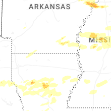
Arkansas
| Local Time | Report Details |
|---|---|
| 2:36 PM CDT | Quarter sized hail reported near Harrison, AR, 63.9 miles S of Springfield, MO, report from mping: quarter (1.00 in.). |
| 2:56 PM CDT | Half Dollar sized hail reported near Yellville, AR, 66.7 miles SSE of Springfield, MO |
| 3:00 PM CDT | Ping Pong Ball sized hail reported near Clarkridge, AR, 72.5 miles SE of Springfield, MO |
| 3:03 PM CDT | Quarter sized hail reported near Mountain Home, AR, 83.6 miles SE of Springfield, MO |
| 3:21 PM CDT | Ping Pong Ball sized hail reported near Lakeview, AR, 70.3 miles SE of Springfield, MO |
| 3:41 PM CDT | Half Dollar sized hail reported near Gamaliel, AR, 80.1 miles SE of Springfield, MO |
| 3:56 PM CDT | Golf Ball sized hail reported near Mountain Home, AR, 80.5 miles SE of Springfield, MO |
| 3:56 PM CDT | Baseball sized hail reported near Viola, AR, 88.3 miles SSW of Salem, MO, report from mping: baseball (2.75 in.). |
| 4:02 PM CDT | Golf Ball sized hail reported near Viola, AR, 88.8 miles SSW of Salem, MO |
| 4:29 PM CDT | Ping Pong Ball sized hail reported near Salem, AR, 88.8 miles S of Salem, MO, **delayed report** public report relayed from local media. |
| 4:42 PM CDT | Quarter sized hail reported near Gassville, AR, 76.7 miles SE of Springfield, MO |
| 4:51 PM CDT | Golf Ball sized hail reported near Gamaliel, AR, 78.3 miles SE of Springfield, MO |
| 4:52 PM CDT | Quarter sized hail reported near Hardy, AR, 91.5 miles S of Salem, MO |
| 5:02 PM CDT | Golf Ball sized hail reported near Yellville, AR, 78.9 miles SSE of Springfield, MO |
| 5:35 PM CDT | Ping Pong Ball sized hail reported near Calico Rock, AR, 95.6 miles N of Little Rock, AR, report from mping: ping pong ball (1.50 in.). |
| 5:55 PM CDT | Quarter sized hail reported near Knobel, AR, 85.5 miles NNW of Memphis, TN |
| 5:59 PM CDT | Half Dollar sized hail reported near Mount Pleasant, AR, 89.4 miles NNE of Little Rock, AR |
| 6:00 PM CDT | Golf Ball sized hail reported near Paragould, AR, 81.9 miles NNW of Memphis, TN, report of golf ball size hail south of highway 90 along highway 141 east of knobel. |
| 6:03 PM CDT | Half Dollar sized hail reported near Corning, AR, 84 miles SW of Cape Girardeau, MO, report of half dollar size hail. |
| 6:05 PM CDT | Golf Ball sized hail reported near Cave City, AR, 92.4 miles NNE of Little Rock, AR |
| 6:07 PM CDT | Golf Ball sized hail reported near Piggott, AR, 78.5 miles SW of Cape Girardeau, MO, social media report of golf ball size hail between mcdougal and boydsville. |
| 6:25 PM CDT | Golf Ball sized hail reported near Strawberry, AR, 91.2 miles NW of Memphis, TN |
| 6:32 PM CDT | Golf Ball sized hail reported near Piggott, AR, 73.3 miles SSW of Cape Girardeau, MO, golf ball size hail in piggott... ar. |
| 6:43 PM CDT | Hen Egg sized hail reported near Corning, AR, 84.5 miles SW of Cape Girardeau, MO, report of golf ball to egg size hail. |
| 6:58 PM CDT | Quarter sized hail reported near Egypt, AR, 68.7 miles NW of Memphis, TN, report of quarter size hail 2 miles east of egypt. |
| 6:58 PM CDT | Tea Cup sized hail reported near Bradford, AR, 73.4 miles NE of Little Rock, AR |
| 7:10 PM CDT | Siding ripped off of two home in craighead county AR, 67.4 miles NW of Memphis, TN |
| 7:15 PM CDT | Quarter sized hail reported near Bono, AR, 67.4 miles NW of Memphis, TN, nickel to quarter size hail in bono. |
| 7:41 PM CDT | Trees and power lines down on bornhoft road and highway 214 e. possible tornad in poinsett county AR, 52.5 miles WNW of Memphis, TN |
| 7:55 PM CDT | Quarter sized hail reported near Harrisburg, AR, 47.3 miles NW of Memphis, TN |
| 7:58 PM CDT | Quarter sized hail reported near Manila, AR, 50.8 miles N of Memphis, TN, delayed report of hail in manila. time is radar estimated. |
| 8:10 PM CDT | Quarter sized hail reported near Trumann, AR, 37.2 miles NW of Memphis, TN, quarter sized hail in payneway. time is radar estimated. |
| 8:25 PM CDT | Tennis Ball sized hail reported near Marked Tree, AR, 33.6 miles NW of Memphis, TN, photo of very large hail from marked tree. time is radar estimated. |
| 8:25 PM CDT | Golf Ball sized hail reported near Marked Tree, AR, 33.1 miles NW of Memphis, TN, several reports of golf ball sized hail in marked tree. |
| 8:25 PM CDT | Golf Ball sized hail reported near Tyronza, AR, 30.1 miles NW of Memphis, TN |
| 8:32 PM CDT | Quarter sized hail reported near Tyronza, AR, 29.2 miles NW of Memphis, TN |
| 8:53 PM CDT | Golf Ball sized hail reported near Joiner, AR, 26.4 miles N of Memphis, TN |
| 9:40 PM CDT | Half Dollar sized hail reported near Palestine, AR, 49.6 miles WSW of Memphis, TN, quarter to half-dollar sized hail. |
| 10:30 PM CDT | Ping Pong Ball sized hail reported near Marianna, AR, 47.7 miles WSW of Memphis, TN |
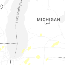
Michigan
| Local Time | Report Details |
|---|---|
| 4:37 PM EDT | Several large trees down in and around new troy. power is ou in berrien county MI, 55.8 miles E of Chicago, IL |
| 4:40 PM EDT | Large pine tree fell on a garage and crushed it. the garage at the house was moved off its foundation. there were shepherds hooks in the hard bent over. there is siding in berrien county MI, 68.2 miles E of Chicago, IL |
| 4:43 PM EDT | Several large trees down in and around buchanan. power is ou in berrien county MI, 65.2 miles E of Chicago, IL |
| 4:50 PM EDT | Tree down on garage and tree down over the road on elkhart rd just east of m62. power lines down at redfield st and conrad rd intersection. agriculture irrigation flipp in cass county MI, 70.9 miles NW of Fort Wayne, IN |
| 4:50 PM EDT | Barn roof ripped off. multiple trees uprooted. tree tops broke in berrien county MI, 66.8 miles E of Chicago, IL |
| 4:51 PM EDT | Downed power poles across the road near the intersection of may st. and conrad rd. some of the poles were snapped at the base... and others were snapped about 3 to 4 ft in cass county MI, 71.6 miles NW of Fort Wayne, IN |
| 4:51 PM EDT | Grain bin damaged... possibly completely down in edwardsburg. additional information not available. time estimated by rada in cass county MI, 70.8 miles NW of Fort Wayne, IN |
| 4:54 PM EDT | Corrects previous non-tstm wnd gst report from 1 n benton heights. asos station kbeh benton harbo in berrien county MI, 64.7 miles ENE of Chicago, IL |
| 4:54 PM EDT | Roof blown off buildin in cass county MI, 74.5 miles NW of Fort Wayne, IN |
| 4:54 PM EDT | Tree down on hous in cass county MI, 71.4 miles NW of Fort Wayne, IN |
| 8:56 PM UTC | Facebook picture of roof damage to a barn on m 62... south of monette s in cass county MI, 71.9 miles NW of Fort Wayne, IN |
| 5:00 PM EDT | Storm damage reported in van buren county MI, 49.6 miles SW of Grand Rapids, MI |
| 9:11 PM UTC | Pictures shared on twitter of a barn suffering damage at bradt rd and w main st (m-40). debris through to the northeas in cass county MI, 65.1 miles S of Grand Rapids, MI |
| 5:14 PM EDT | Backyard weather station reported peak wind gust of 68 mph at 514 p in van buren county MI, 57.5 miles S of Grand Rapids, MI |
| 5:14 PM EDT | Mesonet station xstk saugatuck pie in lmz845 county MI, 34.2 miles SW of Grand Rapids, MI |
| 5:15 PM EDT | Trained spotter reports numerous trees or limbs down around the areas of us 131 and sr 21 in st. joseph county MI, 64.7 miles S of Grand Rapids, MI |
| 5:17 PM EDT | Delayed report. time estimated via radar. several photos of downed trees across lawto in van buren county MI, 55.7 miles S of Grand Rapids, MI |
| 5:20 PM EDT | Corrects previous tstm wnd dmg report from 2 ene three rivers. no power at three rivers airport. multiple trees down in the area including near andrews elementar in st. joseph county MI, 66.1 miles NNW of Fort Wayne, IN |
| 5:20 PM EDT | Photos of numerous... large glass panes blown out of a tire shop. seme trailer blown over in parking lot. some roof damage is possibl in st. joseph county MI, 66.2 miles NNW of Fort Wayne, IN |
| 5:20 PM EDT | Numerous reports of trees and branches down at various locations around sturgi in st. joseph county MI, 53.4 miles NNW of Fort Wayne, IN |
| 5:22 PM EDT | Report of thunderstorm damage in the vicinity of 5th and pq ave. time estimated via radar. delayed repor in kalamazoo county MI, 52.3 miles S of Grand Rapids, MI |
| 5:23 PM EDT | Measured at holland asos (kbiv) at 523 pm. delayed repor in allegan county MI, 27.2 miles SW of Grand Rapids, MI |
| 5:25 PM EDT | Huge tree down on powerlines. via nwschat. time estimated by rada in st. joseph county MI, 54.7 miles NNW of Fort Wayne, IN |
| 9:25 PM UTC | Corrects previous non-tstm wnd gst report from 1 e lawton. mesonet station ew6899 lawto in van buren county MI, 55.5 miles S of Grand Rapids, MI |
| 5:29 PM EDT | Delayed report. time estimated by radar. school district reports gymnasium roof blown of in muskegon county MI, 30 miles WNW of Grand Rapids, MI |
| 5:29 PM EDT | Delayed report... photos of gas station canopy blown ove in kalamazoo county MI, 46 miles S of Grand Rapids, MI |
| 5:30 PM EDT | Delayed report. time estimated via radar. numerous reports of downed trees across portage and kalamazo in kalamazoo county MI, 48.2 miles S of Grand Rapids, MI |
| 5:30 PM EDT | Tree branches down... barn is leaning. 72 mph wind gust from public report... time estimated via rada in ottawa county MI, 14.6 miles SW of Grand Rapids, MI |
| 5:31 PM EDT | Asos station kazo kalamazoo/bc intl airpor in kalamazoo county MI, 51.2 miles S of Grand Rapids, MI |
| 5:32 PM EDT | Minor roof damage as storms went throug in kalamazoo county MI, 49.5 miles S of Grand Rapids, MI |
| 5:40 PM EDT | Awos station koeb coldwate in branch county MI, 58.4 miles N of Fort Wayne, IN |
| 5:42 PM EDT | Delayed report. time estimated via radar. numerous large trees down. steeple removed from church buildin in calhoun county MI, 51.2 miles SSE of Grand Rapids, MI |
| 5:44 PM EDT | Delayed report. time estimated via radar. photos on social media show bricks blown off of a roof parapet wall... two barns damaged... and several trees dow in calhoun county MI, 69.2 miles SSE of Grand Rapids, MI |
| 5:45 PM EDT | Trained spotter reports significant tree damage... a flattened barn... and debris spread. delayed repor in kent county MI, 11.2 miles SSE of Grand Rapids, MI |
| 5:47 PM EDT | Asos station kbtl battle creek executive airpor in calhoun county MI, 50 miles SSE of Grand Rapids, MI |
| 5:49 PM EDT | Delayed report. time estimated via radar. several reports of trees and wires dow in barry county MI, 20.7 miles SSE of Grand Rapids, MI |
| 5:50 PM EDT | Delayed report. time estimated via radar and asos observation. numerous trees downe in kent county MI, 9.2 miles E of Grand Rapids, MI |
| 5:50 PM EDT | Roof blown off a barn. also a tree on a hous in barry county MI, 34.8 miles SSE of Grand Rapids, MI |
| 5:50 PM EDT | Asos station kgrr gerald r ford int in kent county MI, 9.7 miles SE of Grand Rapids, MI |
| 5:55 PM EDT | 72 mph gust reported by trainer spotter. time estimated via radar. delayed repor in barry county MI, 37.4 miles SE of Grand Rapids, MI |
| 6:00 PM EDT | Trees and power lines down throughout the count in hillsdale county MI, 63.2 miles NNE of Fort Wayne, IN |
| 6:00 PM EDT | Trees dow in hillsdale county MI, 62.6 miles NNE of Fort Wayne, IN |
| 6:00 PM EDT | Delayed report. time estimated via radar. one electric transmission tower downed and another bent. possible tornad in newaygo county MI, 27.9 miles N of Grand Rapids, MI |
| 10:00 PM UTC | Corrects previous non-tstm wnd gst report from 2 nw sparta. mesonet station mispn 2.0 nw sparta (mawn in kent county MI, 15.2 miles NNW of Grand Rapids, MI |
| 6:02 PM EDT | Delayed report. time estimated via radar. garage doors blown out at ionia co road dept. buildin in ionia county MI, 28 miles E of Grand Rapids, MI |
| 6:10 PM EDT | Mesonet station mc151 us-131 mile marker 104. in kent county MI, 18.2 miles NNE of Grand Rapids, MI |
| 6:11 PM EDT | Report of 62 mph winds via trained spotter. numerous trees dow in barry county MI, 24.4 miles SE of Grand Rapids, MI |
| 6:13 PM EDT | Pictures of large tree limbs down and multiple trees down on roads or partially uproote in lenawee county MI, 66.7 miles NE of Fort Wayne, IN |
| 6:17 PM EDT | Asos station kjxn jackson county-reynolds field airpor in jackson county MI, 64.9 miles SW of Flint, MI |
| 6:17 PM EDT | Delayed report. time estimated via radar and asos observation. numerous large trees and branches down in the jackson are in jackson county MI, 64.2 miles SW of Flint, MI |
| 10:20 PM UTC | Delayed report. time estimated via radar. wire down on grand ledge hw in eaton county MI, 40.7 miles ESE of Grand Rapids, MI |
| 6:22 PM EDT | Delayed report. time estimated via radar. several downed trees and large limbs in grand ledge are in eaton county MI, 49.1 miles ESE of Grand Rapids, MI |
| 6:24 PM EDT | Delayed report. time estimated via radar. several photos of social media on downed tree in ionia county MI, 39.7 miles E of Grand Rapids, MI |
| 10:28 PM UTC | Delayed report. time estimated via radar. barn with roof partially remove in montcalm county MI, 44.1 miles ENE of Grand Rapids, MI |
| 6:28 PM EDT | Delayed report. time estimated via radar. large tree down over dexter trai in ingham county MI, 45.3 miles SW of Flint, MI |
| 6:30 PM EDT | Quarter sized hail reported near Jackson, MI, 57.6 miles SW of Flint, MI, report from mping: quarter (1.00 in.) time estimated via radar. |
| 6:32 PM EDT | Asos station klan lansin in clinton county MI, 48.1 miles WSW of Flint, MI |
| 6:37 PM EDT | Roof blown off an assisted living center. all 7 residents saf in ingham county MI, 38.7 miles SW of Flint, MI |
| 6:51 PM EDT | 2 foot diameter tree down near liberty and dornoch rd in washtenaw county MI, 51.7 miles S of Flint, MI |
| 6:54 PM EDT | Estimated wind gusts with pea to half inch sized hail in washtenaw county MI, 49.8 miles S of Flint, MI |
| 6:57 PM EDT | Tree uprooted and street sign bent in shiawassee county MI, 26.2 miles W of Flint, MI |
| 6:57 PM EDT | Trees down including one partially uprooted taking the sidewalk with it on broadway a in shiawassee county MI, 24.1 miles W of Flint, MI |
| 6:59 PM EDT | Large pine uprooted and down on a garage in shiawassee county MI, 16.9 miles WSW of Flint, MI |
| 7:05 PM EDT | Large pine snapped and partially uprooted in genesee county MI, 9.6 miles WSW of Flint, MI |
| 7:05 PM EDT | Video of large tree uprooted in wayne county MI, 59.4 miles S of Flint, MI |
| 7:07 PM EDT | Storm damage reported in wayne county MI, 53.8 miles S of Flint, MI |
| 7:07 PM EDT | Emergency management reports mobile homes damaged in the holiday estates mobile home par in wayne county MI, 51.4 miles S of Flint, MI |
| 7:07 PM EDT | Spotter reported trees uprooted near the intersection of morrish adn lennon roads and on van vleet roa in genesee county MI, 7.6 miles WSW of Flint, MI |
| 7:09 PM EDT | Storm damage reported in genesee county MI, 4.3 miles SW of Flint, MI |
| 7:10 PM EDT | Measured on private weather station in genesee county MI, 2.1 miles S of Flint, MI |
| 7:11 PM EDT | Pictures of damaged fencing... shredded netting... and snapped poles at powers catholic high school baseball fields in genesee county MI, 1 miles SW of Flint, MI |
| 7:12 PM EDT | Also reported quarter sized hail in genesee county MI, 2.1 miles S of Flint, MI |
| 7:12 PM EDT | Report of numerous 8 to 10 inch diameter tree limbs down across grand blanc... downed power lines... and a few flooded roads. a few smaller trees were also uprooted. es in genesee county MI, 6.5 miles SSE of Flint, MI |
| 7:17 PM EDT | Storm damage reported in wayne county MI, 56.9 miles SSE of Flint, MI |
| 7:18 PM EDT | Dispatch reports multiple trees down on houses in the southern part of the count in saginaw county MI, 19.7 miles NNW of Flint, MI |
| 7:30 PM EDT | Tree down on wires near livernois and wendelton roads in oakland county MI, 40.8 miles SE of Flint, MI |
| 7:33 PM EDT | Dispatch reports trees and wires down throughout area in lapeer county MI, 22.7 miles ENE of Flint, MI |
| 7:38 PM EDT | Dispatch reports trees down near jewell and 27 mile road in macomb county MI, 39.3 miles ESE of Flint, MI |
| 7:52 PM EDT | Dispatch reports trees down in macomb county MI, 49.4 miles ESE of Flint, MI |
| 8:15 PM EDT | 2 foot diameter tree down on griswold and oak road in st. clair county MI, 63.2 miles E of Flint, MI |
Ohio
| Local Time | Report Details |
|---|---|
| 6:01 PM EDT | Outbuilding lost its roof. roof was toppled into the adjacent fiel in williams county OH, 44 miles NE of Fort Wayne, IN |
| 7:08 PM EDT | Power lines downed near whitmer high schoo in lucas county OH, 89.2 miles S of Flint, MI |
| 7:08 PM EDT | Multiple trees and power lines down near the intersection of laskey and secor road in lucas county OH, 88.5 miles ENE of Fort Wayne, IN |
| 8:40 PM EDT | Multiple trailers off foundation in trailer park on hamilton trenton road. time estimated from rada in butler county OH, 23 miles N of Cincinnati, OH |
| 8:49 PM EDT | Quarter sized hail reported near Cincinnati, OH, 8.4 miles W of Cincinnati, OH |
| 8:51 PM EDT | Poles ripped apart... fence down... yard furniture everywhere. time estimated from rada in butler county OH, 24.8 miles NNE of Cincinnati, OH |
| 8:55 PM EDT | Multiple trees with large branches broken off... shingle damage to hom in warren county OH, 19.8 miles NNE of Cincinnati, OH |
| 8:59 PM EDT | Trees down on the news. time estimated from rada in warren county OH, 22.2 miles NE of Cincinnati, OH |
| 8:59 PM EDT | Multiple trees were downe in warren county OH, 21.9 miles NE of Cincinnati, OH |
| 9:00 PM EDT | Measured with davi in montgomery county OH, 43 miles NNE of Cincinnati, OH |
| 9:00 PM EDT | Tree downed with powerlines down along hart rd west of fairgrounds. time estimated by rada in warren county OH, 28.2 miles NNE of Cincinnati, OH |
| 9:01 PM EDT | Shingles down from one home... roof destroyed on another home on vandergrift drive. time estimated from rada in montgomery county OH, 50.2 miles NNE of Cincinnati, OH |
| 9:04 PM EDT | Tree downed near appaloosa circle and us 22. time estimated by rada in warren county OH, 25.1 miles NE of Cincinnati, OH |
| 9:05 PM EDT | Multiple trees down between milford and miami township. time estimated from rada in clermont county OH, 13.9 miles ENE of Cincinnati, OH |
| 9:07 PM EDT | Trees down on social row and wilmington dayton roa in greene county OH, 39.2 miles NNE of Cincinnati, OH |
| 9:09 PM EDT | Damage to home in warren county OH, 36.5 miles NE of Cincinnati, OH |
| 9:10 PM EDT | Pole down on 132 and kunke in warren county OH, 29.2 miles ENE of Cincinnati, OH |
| 9:11 PM EDT | Asos station kday dayton international airpor in montgomery county OH, 57.5 miles NNE of Cincinnati, OH |
| 9:13 PM EDT | Large trees down on 73 east of harveysburg. road closed. time estimated by rada in clinton county OH, 39.1 miles NE of Cincinnati, OH |
| 9:13 PM EDT | Numerous trees downed in caesar creek state park. time estimated by rada in warren county OH, 38.6 miles NE of Cincinnati, OH |
| 9:16 PM EDT | Trees and power poles down. time estimated from rada in clinton county OH, 40.3 miles NE of Cincinnati, OH |
| 9:18 PM EDT | Roof blown off on barn. time estimated by rada in clinton county OH, 40.6 miles NE of Cincinnati, OH |
| 9:27 PM EDT | Power pole down. time estimated from rada in clinton county OH, 40.1 miles ENE of Cincinnati, OH |
| 1:27 AM UTC | Partial collapse of an outbuilding. time estimated by rada in clinton county OH, 41.5 miles ENE of Cincinnati, OH |
| 9:29 PM EDT | Kiln aso in clinton county OH, 44.8 miles ENE of Cincinnati, OH |
| 9:35 PM EDT | Tree uprooted and on road. time estimated from rada in clinton county OH, 46.3 miles ENE of Cincinnati, OH |
| 9:35 PM EDT | Several trees downed... with some outbuilding damage in the 5000 block on antioch road near 729. time estimated by rada in clinton county OH, 47.3 miles ENE of Cincinnati, OH |
| 9:37 PM EDT | Trees down on houses. time estimated from rada in clinton county OH, 47 miles SW of Columbus, OH |
| 9:38 PM EDT | Power poles down on 71. time estimated from rada in fayette county OH, 35.8 miles SW of Columbus, OH |
| 9:42 PM EDT | Multiple trees down in london. time estimated from rada in madison county OH, 24.4 miles WSW of Columbus, OH |
| 9:54 PM EDT | Asos station kiln wilmington air par in clinton county OH, 44.8 miles ENE of Cincinnati, OH |
| 9:55 PM EDT | Power pole down. time estimated from rada in highland county OH, 46.8 miles SSW of Columbus, OH |
| 9:55 PM EDT | Power poles down on 62. time estimated from rada in fayette county OH, 24.2 miles SW of Columbus, OH |
| 10:00 PM EDT | Barn destroyed. time estimated from rada in fayette county OH, 37.5 miles SW of Columbus, OH |
| 10:07 PM EDT | Quarter sized hail reported near Columbus, OH, 8.9 miles NNW of Columbus, OH |
| 10:15 PM EDT | Tree reported down on a home. power lines down in the area. time estimated from rada in franklin county OH, 6.3 miles SSE of Columbus, OH |
| 10:17 PM EDT | Numerous trees downed near east mound st and striebel. time estimated by rada in franklin county OH, 6.1 miles E of Columbus, OH |
| 10:35 PM EDT | One tree down. time estimated from rada in fairfield county OH, 20.1 miles ESE of Columbus, OH |
| 10:41 PM EDT | Multiple trees downed in utica. time estimated by rada in licking county OH, 35.1 miles ENE of Columbus, OH |
| 10:43 PM EDT | A couple of trees down in utica. time estimated from rada in licking county OH, 35.5 miles ENE of Columbus, OH |
| 10:53 PM EDT | Asos station kosu columbus ohio state university airpor in franklin county OH, 9.1 miles NNW of Columbus, OH |
| 10:58 PM EDT | Multiple trees along with a couple of power lines on flagdale rd. time estimated from rada in perry county OH, 38.8 miles ESE of Columbus, OH |
| 11:11 PM EDT | Tree reported down across logan stree in perry county OH, 40.7 miles ESE of Columbus, OH |
| 11:15 PM EDT | Tree and large limbs dow in coshocton county OH, 66.8 miles ENE of Columbus, OH |
| 4:59 AM UTC | Tree blocking co road 1 in lawrence county OH, 52.7 miles W of Charleston, WV |
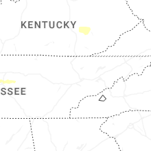
Kentucky
| Local Time | Report Details |
|---|---|
| 6:15 PM CDT | Storm damage reported in ballard county KY, 35.5 miles ESE of Cape Girardeau, MO |
| 7:13 PM CDT | Measured at henshaw fire dep in union county KY, 36.6 miles SW of Evansville, IN |
| 7:30 PM CDT | Storm damage reported in crittenden county KY, 48.4 miles SSW of Evansville, IN |
| 7:30 PM CDT | Quarter sized hail reported near Whitesville, KY, 42.8 miles ESE of Evansville, IN, anywhere from pea to quarter size hail reported. |
| 7:55 PM CDT | Quarter sized hail reported near Owensboro, KY, 32.2 miles ESE of Evansville, IN, report from mping: quarter (1.00 in.). |
| 7:56 PM CDT | Quarter sized hail reported near Fancy Farm, KY, 48.4 miles NNW of Mc Kenzie, TN |
| 7:56 PM CDT | Ping Pong Ball sized hail reported near Fancy Farm, KY, 44 miles NNW of Mc Kenzie, TN |
| 7:56 PM CDT | Golf Ball sized hail reported near Fancy Farm, KY, 44 miles NNW of Mc Kenzie, TN, corrects previous hail report from 2 ssw fancy farm. |
| 8:00 PM CDT | Tree down in road way on lambert schoolhouse rd and scifres ridge r in hancock county KY, 42.3 miles E of Evansville, IN |
| 9:10 PM EDT | Power pole down. time estimated from rada in campbell county KY, 9 miles SE of Cincinnati, OH |
| 8:13 PM CDT | Quarter sized hail reported near Mayfield, KY, 42.5 miles N of Mc Kenzie, TN |
| 9:28 PM EDT | Report of camper flippe in meade county KY, 24.8 miles W of Louisville, KY |
| 9:30 PM EDT | Ky mesonet station in meade count in meade county KY, 26.4 miles W of Louisville, KY |
| 1:40 AM UTC | Mesonet station cw9792 flahert in meade county KY, 24 miles WSW of Louisville, KY |
| 9:41 PM EDT | Dixie hwy and stites station rd. report of trees dow in jefferson county KY, 11.3 miles WNW of Louisville, KY |
| 9:41 PM EDT | Via social media... local media... wdrb... showed photos of trees down in prairie villag in jefferson county KY, 12 miles NW of Louisville, KY |
| 9:42 PM EDT | Tree dow in bullitt county KY, 9.9 miles WNW of Louisville, KY |
| 9:42 PM EDT | Report of tree down in the middle of the road on powerline in jefferson county KY, 10.6 miles NW of Louisville, KY |
| 9:47 PM EDT | Wires down blocking road on new cut rd near southern pkw in jefferson county KY, 13 miles NNW of Louisville, KY |
| 9:48 PM EDT | Road impassable due to debri in jefferson county KY, 8.1 miles NNW of Louisville, KY |
| 9:48 PM EDT | Tree down on vehicle and blocking r in jefferson county KY, 13.5 miles N of Louisville, KY |
| 9:51 PM EDT | Report of tree down on hous in jefferson county KY, 17.9 miles NNE of Louisville, KY |
| 9:51 PM EDT | Wires down around 11210 blue lick r in jefferson county KY, 7.1 miles N of Louisville, KY |
| 9:52 PM EDT | Tree down on home... front of home partially collapse in jefferson county KY, 7.8 miles N of Louisville, KY |
| 9:53 PM EDT | Tree across blankenbaker blocking r in jefferson county KY, 21.2 miles N of Louisville, KY |
| 9:54 PM EDT | Tree down along with powerline in jefferson county KY, 22.2 miles NNE of Louisville, KY |
| 9:56 PM EDT | Asos station ksdf louisville intl airpor in jefferson county KY, 13.3 miles N of Louisville, KY |
| 9:58 PM EDT | Power lines down at oak street and s preston hwy... lebanon junctio in bullitt county KY, 10.2 miles S of Louisville, KY |
| 9:08 PM CDT | Quarter sized hail reported near Gracey, KY, 68.9 miles NW of Nashville, TN, 1 inch hail reported south of gracey. |
| 10:15 PM EDT | Awos station kbry bardstow in nelson county KY, 16.6 miles SE of Louisville, KY |
| 9:22 PM CDT | Quarter sized hail reported near Elkton, KY, 63.9 miles NNW of Nashville, TN, 1 inch hail reported nnw of allegre... near the christian and todd county line. |
| 10:29 PM EDT | One tree down near gratz. time estimated from rada in owen county KY, 49.5 miles SSW of Cincinnati, OH |
| 9:39 PM CDT | Storm damage reported in todd county KY, 60.2 miles NNW of Nashville, TN |
| 10:57 PM EDT | Social media image shows damage to the front of the faith baptist churc in scott county KY, 47 miles NW of Irvine, KY |
| 11:30 PM EDT | Image posted in nws chat of tree debris across a road in buckey in garrard county KY, 29.4 miles W of Irvine, KY |
| 4:16 AM UTC | Powerlines were reported to have been blown down at 650 dry creek road clearfield. time is estimated from rada in rowan county KY, 44.4 miles NE of Irvine, KY |
| 4:20 AM UTC | Powerlines were reported to have been blown down at 2966 dry creek road clearfield. time is estimated from rada in rowan county KY, 45.4 miles NE of Irvine, KY |
| 4:36 AM UTC | Tree on power lin in greenup county KY, 69.1 miles WNW of Charleston, WV |
| 12:48 AM EDT | Pulaski county dispatch reported a downed tree on a powerline on the 450 block of sierra dr near burnside. time is based off of time of 911 cal in pulaski county KY, 57.8 miles SW of Irvine, KY |
| 4:51 AM UTC | Trees down on grandview driv in greenup county KY, 59.6 miles WNW of Charleston, WV |
| 4:53 AM UTC | Pulaski county 911 center reported several trees down at the intersection of malvin hill church road and jessie sears road. time estimated from rada in pulaski county KY, 50.7 miles SSW of Irvine, KY |
| 4:53 AM UTC | Pulaski county 911 center reported a tree down near the 10000 block of ky 192. time estimated from rada in pulaski county KY, 50.2 miles SSW of Irvine, KY |
| 4:58 AM UTC | Pulaski county 911 center reported a tree down near the intersection ky 192 and providence road. time estimated from rada in pulaski county KY, 50.5 miles SSW of Irvine, KY |
| 5:13 AM UTC | Report including video via social medi in wolfe county KY, 28.8 miles E of Irvine, KY |
| 1:20 AM EDT | A tree was reported to have been blown down near the intersection of charlie sizemore road and us 421. the event time is radar estimate in clay county KY, 36.8 miles SSE of Irvine, KY |
| 5:41 AM UTC | Perry county 911 center reported utility lines down near the 2700 block of ky-28 near the grapevine area. time estimated from rada in perry county KY, 43.3 miles SE of Irvine, KY |
| 5:51 AM UTC | Perry county 911 center reported a tree down on ky-451 before messer branch road. time estimated from rada in perry county KY, 52.7 miles SE of Irvine, KY |
| 5:58 AM UTC | Public report relayed by broadcast from valley road of several trees that have blown down and blocked the roa in floyd county KY, 60.9 miles ESE of Irvine, KY |
| 6:04 AM UTC | Social media report said trees and powerlines were down on the 120 block of turner branch road in easter in floyd county KY, 64 miles E of Irvine, KY |
| 2:07 AM EDT | Trees and powerlines were reported to have been blown down in the printer community. the event time is radar estimate in floyd county KY, 68.2 miles E of Irvine, KY |
| 6:14 AM UTC | Trees and powerlines were reported to have been blown down in the beaver community near ky 979. the event time is radar estimate in floyd county KY, 60.8 miles NNW of Bristol, TN |
| 2:17 AM EDT | A roof was blown off a structure with additional damage to that structures second story with debris reported to be blocking all lanes of us 23. powerlines were also blo in pike county KY, 68.8 miles NNW of Bristol, TN |
| 2:19 AM EDT | Powerlines were reported to have been blown down at the mouth of long fork. the event time is radar estimate in pike county KY, 55.5 miles NNW of Bristol, TN |
Tennessee
| Local Time | Report Details |
|---|---|
| 9:04 PM CDT | Quarter sized hail reported near Burlison, TN, 31.3 miles NNE of Memphis, TN |
| 9:36 PM CDT | Ping Pong Ball sized hail reported near Gadsden, TN, 35.5 miles SW of Mc Kenzie, TN, ems director reported just below golf ball size hail east of gadsden tn within crockett county. |
| 9:54 PM CDT | Half Dollar sized hail reported near Jackson, TN, 35.8 miles SSW of Mc Kenzie, TN |
| 9:55 PM CDT | Quarter sized hail reported near Brighton, TN, 27.7 miles NE of Memphis, TN |
| 10:03 PM CDT | Half Dollar sized hail reported near Jackson, TN, 38.1 miles SSW of Mc Kenzie, TN, just larger than quarter sized hail in jackson. |
| 10:10 PM CDT | Ping Pong Ball sized hail reported near Memphis, TN, 13.6 miles ENE of Memphis, TN |
| 10:18 PM CDT | Quarter sized hail reported near Beech Bluff, TN, 32.8 miles S of Mc Kenzie, TN |
| 10:20 PM CDT | Quarter sized hail reported near Memphis, TN, 17 miles ENE of Memphis, TN, several reports coming in of quarter to half dollar sized hail in the bartlett/lakeland/arlington area. |
| 10:28 PM CDT | Report of tree on home on circle drive. time estimated on rada in robertson county TN, 22.8 miles NNW of Nashville, TN |
| 10:37 PM CDT | Tree down on home on shady hill r in henderson county TN, 34.7 miles SSE of Mc Kenzie, TN |
| 3:54 AM UTC | Quarter sized hail reported near Somerville, TN, 40 miles E of Memphis, TN |
| 11:06 PM CDT | Multiple trees down on highway 100 east near the williamson county line. time estimated on rada in williamson county TN, 25.2 miles SW of Nashville, TN |
| 11:06 PM CDT | Fire at a substation near highway 100/pinewood. 776 power outages in the area. time estimated on rada in williamson county TN, 28.4 miles WSW of Nashville, TN |
| 11:12 PM CDT | Tspotter report of groups of trees down and damage in the area of highway 100/840/pinewood road/liberty road. time is radar estimate in williamson county TN, 27 miles SW of Nashville, TN |
| 11:41 PM CDT | Quarter sized hail reported near Brentwood, TN, 13.9 miles SSW of Nashville, TN, tspotter report of quarter size hail at mckays mill in franklin. |
| 11:41 PM CDT | Quarter sized hail reported near Franklin, TN, 17.9 miles S of Nashville, TN, quarter size hail near interstate 65 and highway 96 in franklin. |
| 11:43 PM CDT | Ping Pong Ball sized hail reported near Franklin, TN, 17.8 miles S of Nashville, TN, photo received of ping pong size hail on lena lane in franklin. |
| 12:00 AM CDT | Hen Egg sized hail reported near Nolensville, TN, 16 miles SSE of Nashville, TN, tspotter photo received of 2 inch size hail southwest of nolensville. |
| 12:05 AM CDT | Tspotter photos received of minor damage to roof of a home on fairview blvd (highway 100). time is radar estimate in williamson county TN, 27.4 miles SW of Nashville, TN |
| 12:05 AM CDT | Trees down at the crossroad of hampshire pike and old state road near columbia. time is radar estimate in maury county TN, 47.9 miles SW of Nashville, TN |
| 12:05 AM CDT | Hen Egg sized hail reported near Smyrna, TN, 18.5 miles SE of Nashville, TN, tspotter photo received of 2 inch size hail between nolensville and smyrna. time is radar estimated. |
| 12:05 AM CDT | At least one home destroyed... multiple homes damaged... and multiple power outages in the hampshire area. time is radar estimate in maury county TN, 49.4 miles SW of Nashville, TN |
| 12:08 AM CDT | Cross bridges road unpassable due to damage in the area. other reports of electrical poles down... damage to structures and multiple trees down in maury county. time is in maury county TN, 47.8 miles SSW of Nashville, TN |
| 1:05 AM CDT | Tspotter report of 3 large trees down and shingle damage to a home near locks creek/county lane east of readyville. time is radar estimate in cannon county TN, 42.7 miles ESE of Nashville, TN |
| 1:08 AM CDT | Quarter sized hail reported near Pickwick Dam, TN, 36.4 miles WNW of Florence, AL |
West Virginia
| Local Time | Report Details |
|---|---|
| 5:18 AM UTC | Small tree down that bus cannot get past on toms creek rd. near shrewsbury rd.... garretts creek rd. and whites creek rd. time estimated from rada in wayne county WV, 46.1 miles W of Charleston, WV |
| 5:19 AM UTC | Tree on power lin in wayne county WV, 43.3 miles W of Charleston, WV |
| 5:29 AM UTC | Tree on power lin in jackson county WV, 39.4 miles N of Charleston, WV |
| 5:50 AM UTC | Tree down in the roadway and possible phone lines involved on mclane pike... liberty. time estimated from rada in putnam county WV, 17.6 miles NNW of Charleston, WV |
| 5:51 AM UTC | Tree down on charleston roa in jackson county WV, 25.5 miles N of Charleston, WV |
| 5:58 AM UTC | Power lines down across driveway on lost run rd. time estimated from rada in ritchie county WV, 67.9 miles NNE of Charleston, WV |
| 6:17 AM UTC | Tree down on taylor drain roa in doddridge county WV, 57.3 miles WNW of Elkins, WV |
| 6:58 AM UTC | Tree on power lin in mingo county WV, 56.9 miles SSW of Charleston, WV |
| 7:07 AM UTC | Tree on power lin in mcdowell county WV, 60.3 miles S of Charleston, WV |
| 7:16 AM UTC | Tree down in branton. time estimated from rada in wyoming county WV, 51.7 miles S of Charleston, WV |
| 7:23 AM UTC | Tree down. time estimated from rada in wyoming county WV, 53.4 miles S of Charleston, WV |
Virginia
| Local Time | Report Details |
|---|---|
| 6:05 AM UTC | Tree on power lin in buchanan county VA, 51.4 miles NNE of Bristol, TN |
| 6:58 AM UTC | Tree on power lin in buchanan county VA, 51 miles NNE of Bristol, TN |
| 3:12 AM EDT | Tree on power lin in buchanan county VA, 40.3 miles NNE of Bristol, TN |
Louisiana
| Local Time | Report Details |
|---|---|
| 1:20 AM CDT | Golf Ball sized hail reported near Campti, LA, 56.1 miles SE of Shreveport, LA, golfball sized hail reported in the campti community. |
| 2:12 AM CDT | Quarter sized hail reported near Many, LA, 66.9 miles SSE of Shreveport, LA, quarter size hail reported in many... louisiana. |
| 2:19 AM CDT | Golf Ball sized hail reported near Winnfield, LA, 69.8 miles SSW of Bastrop, LA, report of golf ball size hail in the colgrade community east of winnfield. |
| 2:55 AM CDT | Quarter sized hail reported near Bentley, LA, 93.2 miles SSW of Bastrop, LA, reports of quarter size hail in the community of bentley la. |
| 3:00 AM CDT | Half Dollar sized hail reported near Pollock, LA, 90.8 miles SSW of Bastrop, LA, half dollar sized hail in pollock... louisiana. |
Connect with Interactive Hail Maps