

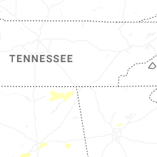
Hail Map for Monday, March 31, 2025

Number of Impacted Households on 3/31/2025
0
Impacted by 1" or Larger Hail
0
Impacted by 1.75" or Larger Hail
0
Impacted by 2.5" or Larger Hail
Square Miles of Populated Area Impacted on 3/31/2025
0
Impacted by 1" or Larger Hail
0
Impacted by 1.75" or Larger Hail
0
Impacted by 2.5" or Larger Hail

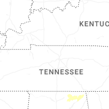

Cities Most Affected by Hail Storms of 3/31/2025
| Hail Size | Demographics of Zip Codes Affected | ||||||
|---|---|---|---|---|---|---|---|
| City | Count | Average | Largest | Pop Density | House Value | Income | Age |
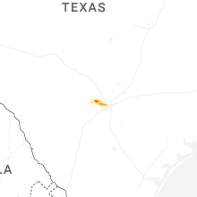
| San Antonio, TX | 6 | 1.79 | 2.00 | 3008 | $84k | $46.1k | 30.1 |
| Eutawville, SC | 1 | 1.75 | 1.75 | 95 | $83k | $28.2k | 45.4 |
| Mico, TX | 1 | 1.75 | 1.75 | 18 | $122k | $41.0k | 45.0 |
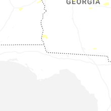
Hail and Wind Damage Spotted on 3/31/2025
Filter by Report Type:Hail ReportsWind Reports
States Impacted
Louisiana, Alabama, Florida, Georgia, South Carolina, North Carolina, Pennsylvania, Texas, Virginia, Maryland, Wyoming, Delaware, Nebraska, New JerseyLouisiana
| Local Time | Report Details |
|---|---|
| 7:00 AM CDT | Trees and power lines down on stilley rd in lorange in tangipahoa county LA, 50 miles NNW of New Orleans, LA |
| 7:12 AM CDT | Corrects previous tstm wnd dmg report from 3 nne gonzales. sheriffs office reports a tree down near bayou nw road and oneil road in ascension paris in ascension county LA, 54.1 miles WNW of New Orleans, LA |
| 7:47 AM CDT | Corrects previous non-tstm wnd gst report from 1 ssw mandeville. mesonet station xmvl mandevill in gmz530 county LA, 28 miles N of New Orleans, LA |
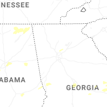
Alabama
| Local Time | Report Details |
|---|---|
| 7:02 AM CDT | Trees down on cr 6 in fayette county AL, 51.3 miles W of Birmingham, AL |
| 7:53 AM CDT | Quarter sized hail reported near Scottsboro, AL, 50.7 miles WSW of Chattanooga, TN, nickel to quarter sized hail in scottsboro. |
| 10:39 AM CDT | There were 10 to 12 campers damaged at pineywoods campground as winds moved into the area off of the wate in randolph county AL, 51.9 miles N of Auburn, AL |
| 10:51 AM CDT | Trees down along parts of highway 28 in lee county AL, 11.3 miles E of Auburn, AL |
| 10:55 AM CDT | Ping Pong Ball sized hail reported near Salem, AL, 15.3 miles E of Auburn, AL, reported at wacoochee elementary school. |
| 10:55 AM CDT | Trees down in the salem are in lee county AL, 14.1 miles E of Auburn, AL |
| 11:46 AM CDT | A member of the emergency communications department in coffee county reported a few small trees down along laurel breeze drive. time estimated by rada in coffee county AL, 75.4 miles NNE of Miramar Beach, FL |
| 11:50 AM CDT | An oak tree was uprooted at enterprise high schoo in coffee county AL, 72 miles NNE of Miramar Beach, FL |
| 11:51 AM CDT | Trees were blown down on cherry hill road... pinehurst dr... sylvan dr... and janice street according to a report on social medi in coffee county AL, 72.4 miles NNE of Miramar Beach, FL |
| 12:13 PM CDT | A fallen tree resulted in a power outage via the alabama power outage ma in dale county AL, 78.7 miles NE of Miramar Beach, FL |
| 12:15 PM CDT | Trees and power lines down at highways 123 and 13 in dale county AL, 80.6 miles NNE of Miramar Beach, FL |
| 12:22 PM CDT | Geneva county 911 dispatch reported numerous trees down behind the fadette volunteer fire station. time estimated by rada in geneva county AL, 67.4 miles NE of Miramar Beach, FL |
| 12:22 PM CDT | Geneva county 911 dispatch reported numerous trees and powerlines down near slocomb and malvern... primarily along south county road 4 in geneva county AL, 72.7 miles NE of Miramar Beach, FL |
| 12:23 PM CDT | Dale county 911 call center reports trees and power lines down at hwy 123 and cr 134. time estimated by rada in dale county AL, 80.6 miles NNE of Miramar Beach, FL |
| 12:23 PM CDT | Dale county 911 call center reported trees and powerlines down here the intersection of south cr 67 and cr 14. time estimated by rada in dale county AL, 85.7 miles NE of Miramar Beach, FL |
| 12:27 PM CDT | Trees and power lines down at south cr 67 and cr 1 in dale county AL, 85.7 miles NE of Miramar Beach, FL |
| 12:32 PM CDT | *** 5 inj *** corrects previous tstm wnd dmg report from 1 s dothan. a possible tornado hit the dothan preparatory academy causing the roof to collapse. some students s in houston county AL, 81.5 miles NE of Miramar Beach, FL |
| 12:34 PM CDT | Several trees were downed on memphis street... impacting at least one hom in houston county AL, 81.9 miles NE of Miramar Beach, FL |
| 12:39 PM CDT | Henry county 911 dispatch reported a tree down along us hwy 431 near the border of henry and houston county. time estimated by rada in henry county AL, 87.8 miles NW of Tallahassee, FL |
| 12:47 PM CDT | The public reported via social media that power poles were down along gene terry roa in houston county AL, 76.6 miles NW of Tallahassee, FL |
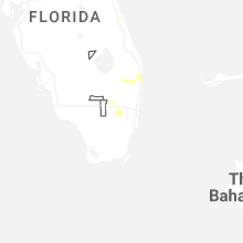
Florida
| Local Time | Report Details |
|---|---|
| 10:57 AM CDT | Asos station kpns pensacola observed a wind gust to 63mp in escambia county FL, 49.4 miles W of Miramar Beach, FL |
| 11:05 AM CDT | Minor shingle damage... fences blown down... decorative shutters blown off a hom in santa rosa county FL, 47.3 miles WNW of Miramar Beach, FL |
| 11:45 AM CDT | Walton county 911 dispatch reported several trees and powerlines down near the intersection of hwy 2 and us hwy 331. time estimated by rada in walton county FL, 33.4 miles NNE of Miramar Beach, FL |
| 12:20 PM CDT | Emergency management reported a tree down along j s jones rd. time estimated by rada in holmes county FL, 63.3 miles NE of Miramar Beach, FL |
| 12:24 PM CDT | Holmes county emergency management reported a tree down along hwy 177a. time estimated by rada in holmes county FL, 48.5 miles NE of Miramar Beach, FL |
| 12:45 PM CDT | The west florida electric coop reported damage to several three-phase poles in the area of peanut roa in jackson county FL, 65.1 miles ENE of Miramar Beach, FL |
| 12:55 PM CDT | Bay county emergency manager shared pictures of portions of the metal roof peeled off the oasis worship center along front beach road. timing estimated by rada in bay county FL, 37.2 miles ESE of Miramar Beach, FL |
| 1:11 PM CDT | Corrects previous non-tstm wnd dmg report from 5 e round lake. jackson county 911 dispatch reported a tree down near the intersection of fairview road and laramore road in jackson county FL, 63.8 miles WNW of Tallahassee, FL |
| 1:38 PM CDT | Calhoun county florida dispatch reported a tree down along hwy 69 near macedonia churc in calhoun county FL, 46.3 miles W of Tallahassee, FL |
| 3:19 PM EDT | Gadsden county dispatch reported a tree down in havana. time estimated by rada in gadsden county FL, 14.6 miles NNW of Tallahassee, FL |
| 3:32 PM EDT | Emergency manager reported a tree down on a hous in leon county FL, 8.7 miles NNE of Tallahassee, FL |
| 3:32 PM EDT | Emergency manager reports a tree down near the intersection of pimlico drive and jamaica cour in leon county FL, 8.8 miles NE of Tallahassee, FL |
| 3:40 PM EDT | Emergency manager reports much of tram road covered in branches and about 4 trees down near and west of the intersection of tram road and saint joe roa in leon county FL, 9.2 miles ESE of Tallahassee, FL |
| 8:12 PM EDT | Cocoa - patrick air force base measured a peak wind gust of 59mph/51kt from the northwest at 8:12 p in brevard county FL, 51.9 miles ESE of Orlando, FL |
| 8:21 PM EDT | Melbourne international airport measured a peak wind gust of 61mph/53kt from the northwest at 8:21 pm. earlier... a gust to 52mph/45kt occurred at 8:20 p in brevard county FL, 53.6 miles SE of Orlando, FL |
| 8:27 PM EDT | Quarter sized hail reported near Lake Worth, FL, 45.8 miles S of Port Saint Lucie, FL, trained spotter reported quarter sized hail with passing thunderstorm. |
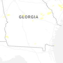
Georgia
| Local Time | Report Details |
|---|---|
| 12:02 PM EDT | Tree down at the intersection of highway 5 and daniel roa in carroll county GA, 54.2 miles WSW of Atlanta, GA |
| 12:02 PM EDT | Tree down at the intersection of highway 5 and reavesville roa in carroll county GA, 53.1 miles WSW of Atlanta, GA |
| 12:03 PM EDT | Trees and powerlines downed on whooping creek r in carroll county GA, 41.1 miles WSW of Atlanta, GA |
| 12:04 PM EDT | Tree down at the intersection of highway 5 and old columbus roa in carroll county GA, 52.3 miles WSW of Atlanta, GA |
| 12:14 PM EDT | Several trees down on homes along cypress circl in carroll county GA, 38.2 miles WSW of Atlanta, GA |
| 12:14 PM EDT | Several trees down on mobile homes along memory springs driv in carroll county GA, 42.7 miles WSW of Atlanta, GA |
| 12:14 PM EDT | Tree down at the intersection of highway 5 and ephesus church roa in carroll county GA, 39.5 miles WSW of Atlanta, GA |
| 12:16 PM EDT | Tree down at the intersection of whooping creek church road and whooping creek road. several trees down further north along whooping creek roa in carroll county GA, 40.6 miles WSW of Atlanta, GA |
| 12:31 PM EDT | One tree down along timber ridge driv in douglas county GA, 18.9 miles W of Atlanta, GA |
| 12:31 PM EDT | Tree down in cvs parking lot at intersection of lower fayetteville and newnan crossing blv in coweta county GA, 33.3 miles SW of Atlanta, GA |
| 12:32 PM EDT | 4 trees down along lower fayetteville rd near shenandoah blv in coweta county GA, 32.4 miles SW of Atlanta, GA |
| 12:33 PM EDT | Corrects previous tstm wnd dmg report from 4 sw thomas crossroads. off duty nws employee reported four trees on powerlines along lower fayetteville road... near the int in coweta county GA, 32 miles SW of Atlanta, GA |
| 12:33 PM EDT | One tree down at the intersection of ga highway 166 and ga highway in douglas county GA, 27.6 miles WSW of Atlanta, GA |
| 12:38 PM EDT | Tree and powerline down along olde oak driv in douglas county GA, 16.1 miles W of Atlanta, GA |
| 12:38 PM EDT | A large tree down along highway 315 across from pine ridge elementary schoo in harris county GA, 38.1 miles E of Auburn, AL |
| 12:45 PM EDT | Amateur radio operator relayed report of a tree down at kelly drive and hip pocket road... resulting in downed power line in fayette county GA, 27.6 miles SSW of Atlanta, GA |
| 12:47 PM EDT | Tree down across chestlehurst roa in coweta county GA, 31.9 miles SSW of Atlanta, GA |
| 12:50 PM EDT | Public relayed a report of a down tree on a home in paces crossing neighborhoo in fayette county GA, 21.6 miles S of Atlanta, GA |
| 12:55 PM EDT | Corrects previous tstm wnd dmg report from 2 wnw jw smith reservoir. 2 to 3 trees downed along south jeff davis driv in fayette county GA, 22 miles S of Atlanta, GA |
| 12:57 PM EDT | A few trees downed near the intersection of highway 92 and hilo road. a few trees were also snappe in fayette county GA, 22.8 miles S of Atlanta, GA |
| 12:59 PM EDT | Report of a large tree down on a home near the intersection of pine st and johnson rd. north of jonesboro... g in clayton county GA, 13.1 miles S of Atlanta, GA |
| 1:13 PM EDT | Report of approximately 40 trees down along brannon r in henry county GA, 21.3 miles SE of Atlanta, GA |
| 1:15 PM EDT | Trees down on residence with structural damage on 1500 block of alverado wa in dekalb county GA, 8.1 miles E of Atlanta, GA |
| 1:15 PM EDT | Emergency management reported numerous trees down along hwy 15 in henry county GA, 21.4 miles SE of Atlanta, GA |
| 1:24 PM EDT | Tree down along troupe smith road s in rockdale county GA, 23 miles ESE of Atlanta, GA |
| 1:24 PM EDT | Trees down along walker road sw near sims elementary schoo in rockdale county GA, 21.6 miles ESE of Atlanta, GA |
| 1:24 PM EDT | 1 to 2 trees down along briar creek court n in rockdale county GA, 23.2 miles ESE of Atlanta, GA |
| 1:24 PM EDT | Tree and powerline down at the intersection of flat shoals road sw and revel cove drive s in rockdale county GA, 21.3 miles ESE of Atlanta, GA |
| 1:26 PM EDT | Tree and powerline down along cherry hill roa in rockdale county GA, 21.3 miles ESE of Atlanta, GA |
| 1:26 PM EDT | Tree down across troupe smith road s in rockdale county GA, 23 miles ESE of Atlanta, GA |
| 1:30 PM EDT | 1 to 2 trees down along riverview roa in monroe county GA, 45.5 miles SSE of Atlanta, GA |
| 1:30 PM EDT | 1 to 2 trees down along high falls roa in monroe county GA, 44 miles SSE of Atlanta, GA |
| 1:40 PM EDT | 1 to 2 trees down near the intersection of ga highway 42 and josey roa in monroe county GA, 58.8 miles SSE of Atlanta, GA |
| 1:41 PM EDT | Tree down at the intersection of center hill church road sw and mcculler roa in walton county GA, 26.1 miles E of Atlanta, GA |
| 1:42 PM EDT | 1 to 2 trees down near the intersection of ga highway 41 south and gose roa in monroe county GA, 60.6 miles SSE of Atlanta, GA |
| 1:43 PM EDT | 1 to 2 trees down near the intersection of blount road and ga highway 42 in monroe county GA, 46.4 miles SSE of Atlanta, GA |
| 1:45 PM EDT | Tree down at the intersection of highway 20 and mccullers roa in walton county GA, 26.3 miles E of Atlanta, GA |
| 1:49 PM EDT | Trees and powerlines down along eatonton street near jasper county health departmen in jasper county GA, 51.4 miles SE of Atlanta, GA |
| 1:50 PM EDT | Powerlines down along center hill church roa in walton county GA, 26.1 miles E of Atlanta, GA |
| 1:50 PM EDT | Tree down along roscoe david roa in walton county GA, 36.8 miles E of Atlanta, GA |
| 1:50 PM EDT | Powerlines down at the intersection of lowry road and bobway trai in walton county GA, 33.2 miles E of Atlanta, GA |
| 1:50 PM EDT | 2 to 3 trees downed along south jeff davis driv in fayette county GA, 22 miles S of Atlanta, GA |
| 1:55 PM EDT | Powerlines down at emmett still road and park stree in walton county GA, 30 miles E of Atlanta, GA |
| 2:00 PM EDT | Two trees down at different locations along pannell roa in walton county GA, 42.1 miles E of Atlanta, GA |
| 2:10 PM EDT | Portions of the roof of a warehouse building located on the 100 block of e marion st were peeled back/damage in putnam county GA, 64.6 miles ESE of Atlanta, GA |
| 2:14 PM EDT | Tree down on utility equipmen in stephens county GA, 43.3 miles WSW of Greenville, SC |
| 2:14 PM EDT | Tree down along bedivere driv in houston county GA, 87.6 miles SSE of Atlanta, GA |
| 2:15 PM EDT | Large tree down on telephone line in houston county GA, 87.6 miles SSE of Atlanta, GA |
| 2:15 PM EDT | Amateur radio operator reported a tree down on a powerline in the 9000 block of hawkinsville road. a few other trees were reported down in the are in bibb county GA, 85.8 miles SSE of Atlanta, GA |
| 2:20 PM EDT | Quarter sized hail reported near Warner Robins, GA, 87.6 miles SSE of Atlanta, GA, amateur radio operator relayed report of trees down on gawin road... badly damaging two vehicles. |
| 2:25 PM EDT | Trees downed across roadway at intersection of forest rd and lanier c in clarke county GA, 62.2 miles ENE of Atlanta, GA |
| 2:32 PM EDT | Miller county 911 dispatch reported a tree down. time estimated by rada in miller county GA, 60.6 miles NNW of Tallahassee, FL |
| 2:35 PM EDT | Terrell county 911 dispatch reported a tree down near herod dover road and sasser herod road. time estimated by rada in terrell county GA, 87.3 miles N of Tallahassee, FL |
| 2:35 PM EDT | Dougherty county 911 call center reported a tree down near the intersection of gillionville road and eight mile road. time estimated by rada in dougherty county GA, 79.2 miles N of Tallahassee, FL |
| 2:37 PM EDT | Dougherty county 911 call center reported a tree down near the intersection of w oakridge dr and martin luther king jr dr. time estimated by rada in dougherty county GA, 76.8 miles N of Tallahassee, FL |
| 2:40 PM EDT | Tree down blocking the road at the 1600 block of s. jefferson stree in dougherty county GA, 77.4 miles W of Douglas, GA |
| 2:42 PM EDT | Trees down on utility equipmen in elbert county GA, 49.9 miles SSW of Greenville, SC |
| 2:50 PM EDT | Report of several trees down around elberto in elbert county GA, 52 miles SSW of Greenville, SC |
| 3:10 PM EDT | Dispatch reports tree down on cobbham r in mcduffie county GA, 30.3 miles W of Augusta, GA |
| 3:10 PM EDT | 511ga reports tree limbs on sr 313 both directions at davis mill road blocking all lane in worth county GA, 63.8 miles WNW of Douglas, GA |
| 3:17 PM EDT | Trees down on hadley ferry road near 3305 hadley ferry road with the north and south bound lanes blocke in grady county GA, 25.2 miles N of Tallahassee, FL |
| 3:25 PM EDT | Dispatch reports power lines down at skyview dr and gordon hwy. time estimated based on rada in richmond county GA, 1.4 miles SSE of Augusta, GA |
| 3:25 PM EDT | Corrects previous tstm wnd dmg for source. dispatch reports power lines down in crystal creek subdivision of martine in columbia county GA, 7.8 miles WNW of Augusta, GA |
| 3:25 PM EDT | Power lines down in crystal creek subdivision of martine in columbia county GA, 7.8 miles WNW of Augusta, GA |
| 3:25 PM EDT | Emergency manager reported a tree down across highway 272 near panther branch roa in washington county GA, 70.2 miles SW of Augusta, GA |
| 3:30 PM EDT | Emergency manager reports tree down on east court st in wrightsvill in johnson county GA, 67.3 miles SW of Augusta, GA |
| 3:32 PM EDT | Quarter sized hail reported near Rentz, GA, 60 miles N of Douglas, GA, amateur radio operator relayed report of dime to quarter size hail off coleman farm road. |
| 3:34 PM EDT | Worth county 911 dispatch reported a tree down near the intersection of hamilton hill road and jodie hobby road. time estimated by rada in worth county GA, 59.9 miles WNW of Douglas, GA |
| 4:05 PM EDT | Dispatch reports a tree down at porter carswell rd and drake rd. time estimated based on rada in burke county GA, 36.5 miles S of Augusta, GA |
| 4:09 PM EDT | There was a report of one tree down in ben hill county. the exact location was not specifie in ben hill county GA, 27.8 miles WNW of Douglas, GA |
| 4:25 PM EDT | Berrien county dispatch reported a powerline down along hall whitley road. timing estimated by rada in berrien county GA, 33.1 miles WSW of Douglas, GA |
| 5:34 PM EDT | On the 100 block of old lake road a tree fell on a home and caused structural damage. time determined by radar dat in effingham county GA, 16.8 miles WNW of Savannah, GA |
| 5:38 PM EDT | Near the 200 block of meadowood lane a tree fell on a home and resulted in damage. time estimated from radar dat in effingham county GA, 15.9 miles WNW of Savannah, GA |
| 5:38 PM EDT | A tree fell on a home near the 300 block of st. paul road. the home was damaged by the tree. time estimated from radar dat in effingham county GA, 16.3 miles WNW of Savannah, GA |
| 5:40 PM EDT | The effingham county emergency manager reported numerous trees and power lines down across an area generally between guyton... ga and the chatham county line. some road in effingham county GA, 13.8 miles NW of Savannah, GA |
| 5:47 PM EDT | Tree down at benton blvd and state hwy 30. time estimated from radar and observation in chatham county GA, 10.7 miles NW of Savannah, GA |
| 6:08 PM EDT | Power lines down at n. cromwell/landon lane. another one also down at 400 block of forrest av in chatham county GA, 8.1 miles SE of Savannah, GA |
| 6:08 PM EDT | Power lines down at n. cromwell/landon lane. another one also down at 400 block of forrest ave. time estimated from rada in chatham county GA, 8.1 miles SE of Savannah, GA |
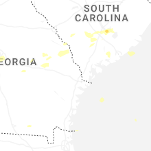
South Carolina
| Local Time | Report Details |
|---|---|
| 2:42 PM EDT | Several trees down around the seneca are in oconee county SC, 22.1 miles WSW of Greenville, SC |
| 2:48 PM EDT | Trees down on utility equipmen in pickens county SC, 16.8 miles WNW of Greenville, SC |
| 2:53 PM EDT | Multiple reports of trees down in the clemson and central area in pickens county SC, 14.5 miles SW of Greenville, SC |
| 3:05 PM EDT | Social media report of a tree down in iv in anderson county SC, 36.1 miles S of Greenville, SC |
| 3:09 PM EDT | Social media report of a tree down in anderson at a residenc in anderson county SC, 22.3 miles S of Greenville, SC |
| 3:16 PM EDT | Social media report of several trees down in the level land communit in anderson county SC, 32 miles S of Greenville, SC |
| 3:22 PM EDT | Multiple trees downed around honea path... including several on utility equipment and power line in anderson county SC, 28.9 miles SSE of Greenville, SC |
| 3:28 PM EDT | Trees down on harmony rd... new hope rd... and whitetown rd in plum branch. time estimated based on rada in mccormick county SC, 31 miles NNW of Augusta, GA |
| 3:29 PM EDT | Utility equipment damaged by falling tree in greenwood county SC, 37.5 miles SSE of Greenville, SC |
| 3:33 PM EDT | Trees down on utility equipmen in greenville county SC, 18.4 miles NE of Greenville, SC |
| 3:35 PM EDT | Tree downed along roper mountain r in greenville county SC, 20.5 miles E of Greenville, SC |
| 3:38 PM EDT | Several trees downed around greenwoo in greenwood county SC, 50.1 miles NNW of Augusta, GA |
| 3:42 PM EDT | Social media report of a large limb down on a power lin in greenville county SC, 24.8 miles ESE of Greenville, SC |
| 3:43 PM EDT | Social media report of a couple trees down in the gray court are in laurens county SC, 31.8 miles ESE of Greenville, SC |
| 3:45 PM EDT | Multiple trees downed around lauren in laurens county SC, 40.6 miles SE of Greenville, SC |
| 3:47 PM EDT | Utility equipment damaged by falling tree in laurens county SC, 30.1 miles ESE of Greenville, SC |
| 3:47 PM EDT | Social media report of a tree down in ninety si in greenwood county SC, 48.4 miles N of Augusta, GA |
| 3:47 PM EDT | Social media report of a tree down in wellfor in spartanburg county SC, 29.2 miles ENE of Greenville, SC |
| 3:47 PM EDT | Tree reported down in the cross hill are in laurens county SC, 50.4 miles SE of Greenville, SC |
| 3:54 PM EDT | Hay shed destroye in laurens county SC, 52 miles SE of Greenville, SC |
| 4:01 PM EDT | Several trees downed around roebuc in spartanburg county SC, 36 miles E of Greenville, SC |
| 4:03 PM EDT | A couple reports of large limbs and a few trees down... mainly on the south side of spartanbur in spartanburg county SC, 39.4 miles ENE of Greenville, SC |
| 4:04 PM EDT | Report of several trees down in the cross keys are in union county SC, 48.2 miles ESE of Greenville, SC |
| 4:15 PM EDT | Tree down across a power lin in union county SC, 56.3 miles SW of Charlotte, NC |
| 4:25 PM EDT | Dispatch reports a tree down on hwy 278 near red oak rd. time estimated based on rada in barnwell county SC, 41.6 miles ESE of Augusta, GA |
| 4:40 PM EDT | Scdps reports tree fell over frank shealy rd near rocky retreat c in lexington county SC, 51.2 miles NE of Augusta, GA |
| 4:40 PM EDT | Social media report of a couple trees down around cheste in chester county SC, 41.8 miles SSW of Charlotte, NC |
| 4:47 PM EDT | Utility equipment damaged from falling tree in york county SC, 32.9 miles SW of Charlotte, NC |
| 5:03 PM EDT | Scdps reports tree and power lines down over vance rd near easterlin r in orangeburg county SC, 38.4 miles WNW of Charleston, SC |
| 5:17 PM EDT | Sc department of safety reports a tree down in the road on smallwood rd... near the intersection with summer r in fairfield county SC, 65 miles S of Charlotte, NC |
| 5:44 PM EDT | Quarter sized hail reported near Branchville, SC, 47 miles W of Charleston, SC, trained spotter reports 1 inch hail in branchville along with debris in the roads via ham radio. |
| 5:47 PM EDT | Tree on building/residenc in colleton county SC, 36.4 miles WSW of Charleston, SC |
| 5:50 PM EDT | Ping Pong Ball sized hail reported near Eutawville, SC, 24 miles NW of Charleston, SC, multiple broadcast media reports ping pong size hail via slack in eutawville with pics. |
| 5:55 PM EDT | Ping Pong Ball sized hail reported near Eutawville, SC, 21.8 miles NW of Charleston, SC, orangeburg county em reports ping pong hail along ash hill dr. |
| 5:55 PM EDT | Golf Ball sized hail reported near Eutawville, SC, 22.2 miles NW of Charleston, SC, trained spotter reported via social media near golf ball size hail in eutaw springs with picture. |
| 6:00 PM EDT | Tree reported down on county line road (sc hwy 41) near the intersection with miracle loo in williamsburg county SC, 36.2 miles NE of Charleston, SC |
| 6:06 PM EDT | Tree on roadwa in colleton county SC, 49.8 miles WSW of Charleston, SC |
| 6:07 PM EDT | Tree on roadwa in colleton county SC, 53 miles WSW of Charleston, SC |
| 6:11 PM EDT | Several trees down across beaufort county between 0600 pm and 0630 pm. time estimated from rada in beaufort county SC, 34.5 miles NE of Savannah, GA |
| 6:11 PM EDT | Tree fell on vehicle. no injuries reporte in beaufort county SC, 13.9 miles NE of Savannah, GA |
| 6:15 PM EDT | Tree in roa in jasper county SC, 40.5 miles NNE of Savannah, GA |
| 6:16 PM EDT | Tree down on two houses. no injuries although occupants displace in beaufort county SC, 29.5 miles NE of Savannah, GA |
| 6:16 PM EDT | Tree down on a vehicle. no injuries reporte in beaufort county SC, 29.6 miles NE of Savannah, GA |
| 6:17 PM EDT | Emergency management reports 9 trees down on hilton head island north of william hilton pkwy in the general area of bear creek golf clu in beaufort county SC, 23.5 miles ENE of Savannah, GA |
| 6:26 PM EDT | Tree down on roadwa in colleton county SC, 45.9 miles SW of Charleston, SC |
| 6:26 PM EDT | Tree on roadwa in jasper county SC, 21.7 miles N of Savannah, GA |
| 6:26 PM EDT | Tree dow in colleton county SC, 46 miles SW of Charleston, SC |
| 6:26 PM EDT | Tree down on roa in colleton county SC, 53.5 miles WSW of Charleston, SC |
| 6:29 PM EDT | Tree down on power line... which resulted in an electrical fire near 215 tall pines road. time estimated from rada in berkeley county SC, 13.4 miles SSW of Charleston, SC |
| 6:40 PM EDT | Tree reported down on seaboard rd between lane and trio in williamsburg county SC, 24.9 miles NNE of Charleston, SC |
| 7:00 PM EDT | Tree reported down on county line road (sc hwy 41) near the intersection with miracle loo in williamsburg county SC, 36.2 miles NE of Charleston, SC |
| 7:10 PM EDT | Tree down on rose hill rd in georgetown county SC, 45.9 miles NE of Charleston, SC |
| 7:16 PM EDT | Tree reported down on bullard road near intersection with pleasant hill dr in georgetown county SC, 49.5 miles NE of Charleston, SC |
| 7:40 PM EDT | Two 30-foot tall trees blown down on breezewood blvd in horry county SC, 67.5 miles ENE of Charleston, SC |
| 7:46 PM EDT | Multiple trees and large tree limbs down on 9th avenue in horry county SC, 68.9 miles WSW of Wilmington, NC |
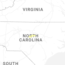
North Carolina
| Local Time | Report Details |
|---|---|
| 5:11 PM EDT | Utility equipment damaged by falling tree in union county NC, 25.9 miles S of Charlotte, NC |
| 5:26 PM EDT | Social media report of a tree down in weddingto in union county NC, 14.6 miles SSE of Charlotte, NC |
| 6:35 PM EDT | Tree down along the roadway of lower river road and ragan roa in lee county NC, 27.2 miles WSW of Raleigh, NC |
| 6:40 PM EDT | Tree down near the intersection of new elam road and thunder valley roa in chatham county NC, 23.4 miles WSW of Raleigh, NC |
| 7:15 PM EDT | Multiple trees down around the youngsville area along holden roa in franklin county NC, 19.2 miles NNE of Raleigh, NC |
| 7:18 PM EDT | Trees down on power equipmen in wake county NC, 3.3 miles SSW of Raleigh, NC |
| 7:28 PM EDT | Powerline down near the intersection of west college street and west noble stree in franklin county NC, 29 miles NE of Raleigh, NC |
| 7:42 PM EDT | Several power outages reported along riley hill road and near lizard lic in wake county NC, 16.3 miles ENE of Raleigh, NC |
| 8:10 PM EDT | Trees down on powerline in franklin county NC, 28.3 miles ENE of Raleigh, NC |
| 8:15 PM EDT | Powerlines down near the intersection of lonnie b green and aurelian springs roa in halifax county NC, 64.2 miles NE of Raleigh, NC |
Pennsylvania
| Local Time | Report Details |
|---|---|
| 5:55 PM EDT | Tree down on car. time estimated from rada in berks county PA, 75.4 miles NNE of Baltimore, MD |
| 7:01 PM EDT | Trees down. time estimated from rada in berks county PA, 73.8 miles S of Scranton, PA |
| 7:48 PM EDT | Large tree down blocking a ramp at us 1 southbound and newark road. time estimated from rada in chester county PA, 59.2 miles NE of Baltimore, MD |
| 8:42 PM EDT | Storm damage reported in philadelphia county PA, 68.4 miles SW of Brooklyn, NY |
| 8:42 PM EDT | Trees and wires down across portions of ne philadelphia. time estimated from rada in philadelphia county PA, 70.9 miles SW of Brooklyn, NY |
Texas
| Local Time | Report Details |
|---|---|
| 5:33 PM CDT | Golf Ball sized hail reported near Mico, TX, 22 miles WNW of San Antonio, TX, report from mping golf ball (1.75 in.). |
| 5:45 PM CDT | Quarter sized hail reported near San Antonio, TX, 12.6 miles WNW of San Antonio, TX, broken window and weather station measured 75 mph. |
| 5:49 PM CDT | Ping Pong Ball sized hail reported near San Antonio, TX, 9.2 miles NW of San Antonio, TX |
| 5:50 PM CDT | Golf Ball sized hail reported near San Antonio, TX, 12.5 miles W of San Antonio, TX, amateur radio passed a report of golf ball size near sea world. time estimated from radar. |
| 5:52 PM CDT | Golf Ball sized hail reported near San Antonio, TX, 12.4 miles W of San Antonio, TX |
| 5:52 PM CDT | Ping Pong Ball sized hail reported near San Antonio, TX, 9.3 miles WNW of San Antonio, TX, report from mping ping pong ball (1.50 in.). |
| 5:55 PM CDT | Golf Ball sized hail reported near San Antonio, TX, 10.1 miles W of San Antonio, TX |
| 5:58 PM CDT | Hen Egg sized hail reported near San Antonio, TX, 12.5 miles W of San Antonio, TX |
| 5:58 PM CDT | Golf Ball sized hail reported near San Antonio, TX, 10 miles W of San Antonio, TX |
| 6:00 PM CDT | Golf Ball sized hail reported near San Antonio, TX, 13 miles W of San Antonio, TX |
| 6:00 PM CDT | Quarter sized hail reported near San Antonio, TX, 11.3 miles W of San Antonio, TX |
| 6:02 PM CDT | Ping Pong Ball sized hail reported near San Antonio, TX, 9.3 miles WNW of San Antonio, TX, report from mping ping pong ball (1.50 in.). |
| 6:10 PM CDT | Ping Pong Ball sized hail reported near San Antonio, TX, 9.4 miles W of San Antonio, TX |
| 6:13 PM CDT | Half Dollar sized hail reported near San Antonio, TX, 14.4 miles W of San Antonio, TX, half dollar size hail near brennan high school. |
| 6:21 PM CDT | Quarter sized hail reported near San Antonio, TX, 18.8 miles WNW of San Antonio, TX, report from mping quarter (1.00 in.). |
Virginia
| Local Time | Report Details |
|---|---|
| 8:15 PM EDT | Multiple trees down at the intersection of lauraville rd & newtown r in caroline county VA, 40.6 miles NE of Richmond, VA |
| 8:20 PM EDT | Multiple trees down near hunters hill road and tidewater trail. time estimated by rada in essex county VA, 51.4 miles NE of Richmond, VA |
| 8:30 PM EDT | A wind gust of 58 mph was measured by a mesonet in colonial beac in westmoreland county VA, 62.1 miles NE of Richmond, VA |
| 8:30 PM EDT | Storm damage reported in anz536 county VA, 63.1 miles NE of Richmond, VA |
| 8:37 PM EDT | Down powerline along west driv in greensville county VA, 56.2 miles S of Richmond, VA |
Maryland
| Local Time | Report Details |
|---|---|
| 8:45 PM EDT | Storm damage reported in charles county MD, 68.3 miles NE of Richmond, VA |
| 9:04 PM EDT | Tree reported down in the great mills area in st. marys county MD, 73.5 miles S of Baltimore, MD |
| 9:55 PM EDT | Storm damage reported in dorchester county MD, 55 miles WNW of Ocean City, MD |
Wyoming
| Local Time | Report Details |
|---|---|
| 7:11 PM MDT | Quarter sized hail reported near Pine Bluffs, WY, 51.6 miles SSW of Scottsbluff, NE |
Delaware
| Local Time | Report Details |
|---|---|
| 9:12 PM EDT | Wires dow in kent county DE, 50.6 miles E of Baltimore, MD |
| 9:15 PM EDT | Downed trees and powerlines. time estimated from rada in new castle county DE, 49.7 miles E of Baltimore, MD |
| 9:15 PM EDT | Downed trees and powerlines. time estimated from rada in new castle county DE, 45.6 miles E of Baltimore, MD |
| 9:16 PM EDT | Smyrna wxflow sit in new castle county DE, 53.6 miles E of Baltimore, MD |
Nebraska
| Local Time | Report Details |
|---|---|
| 7:13 PM MDT | Quarter sized hail reported near Bushnell, NE, 51.2 miles SSW of Scottsbluff, NE |
| 7:30 PM MDT | Quarter sized hail reported near Bushnell, NE, 38.5 miles SSW of Scottsbluff, NE |
| 7:52 PM MDT | Quarter sized hail reported near Kimball, NE, 35.3 miles S of Scottsbluff, NE |
| 7:55 PM MDT | Ping Pong Ball sized hail reported near Kimball, NE, 34.6 miles S of Scottsbluff, NE, late report from local storm chaser. |
| 8:23 PM MDT | Storm damage reported in kimball county NE, 44.7 miles SSE of Scottsbluff, NE |
New Jersey
| Local Time | Report Details |
|---|---|
| 9:42 PM EDT | Wires down. time estimated from rada in cumberland county NJ, 72 miles N of Ocean City, MD |
Connect with Interactive Hail Maps