

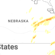
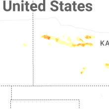
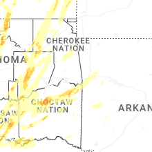
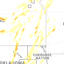
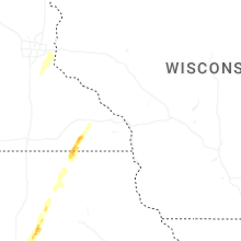
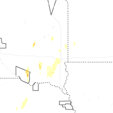
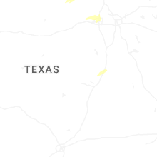
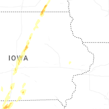
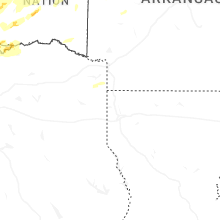
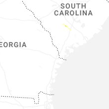
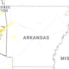
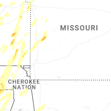
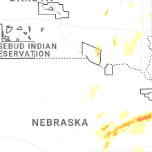
Hail Map for Monday, May 19, 2025
Number of Impacted Households on 5/19/2025
0
Impacted by 1" or Larger Hail
0
Impacted by 1.75" or Larger Hail
0
Impacted by 2.5" or Larger Hail
Square Miles of Populated Area Impacted on 5/19/2025
0
Impacted by 1" or Larger Hail
0
Impacted by 1.75" or Larger Hail
0
Impacted by 2.5" or Larger Hail


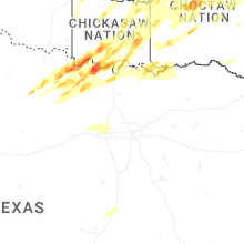
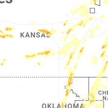
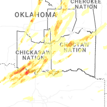
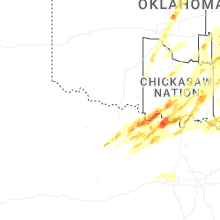


Cities Most Affected by Hail Storms of 5/19/2025
| Hail Size | Demographics of Zip Codes Affected | ||||||
|---|---|---|---|---|---|---|---|
| City | Count | Average | Largest | Pop Density | House Value | Income | Age |
| Saint Jo, TX | 6 | 3.13 | 4.50 | 5 | $46k | $30.5k | 43.1 |
| Tulsa, OK | 5 | 1.80 | 2.00 | 2703 | $110k | $35.2k | 33.8 |
| Columbus, NE | 3 | 2.17 | 3.00 | 100 | $82k | $40.2k | 38.0 |
| Henrietta, TX | 3 | 2.17 | 3.00 | 9 | $46k | $34.2k | 45.1 |
| Kearney, MO | 3 | 2.08 | 2.50 | 234 | $133k | $63.1k | 38.1 |
| Sulphur, OK | 3 | 1.83 | 2.00 | 43 | $53k | $30.6k | 41.9 |
| Montague, TX | 3 | 1.75 | 1.75 | 10 | $42k | $32.0k | 44.7 |
| Edgar, NE | 2 | 2.38 | 2.75 | 3 | $40k | $32.0k | 45.5 |
| Albany, MO | 2 | 1.88 | 2.00 | 17 | $56k | $27.0k | 44.5 |
| Osceola, IA | 2 | 1.88 | 2.00 | 34 | $70k | $33.8k | 39.4 |
| Seminole, OK | 2 | 1.88 | 2.00 | 57 | $46k | $26.8k | 37.5 |
| Ringgold, TX | 2 | 1.88 | 2.00 | 2 | $28k | $28.1k | 42.2 |
| Hooper, NE | 2 | 1.75 | 1.75 | 9 | $78k | $39.3k | 44.5 |
| Lenexa, KS | 2 | 1.75 | 1.75 | 3161 | $145k | $60.3k | 40.4 |
| Leon, OK | 1 | 2.75 | 2.75 | 22 | $25k | $30.6k | 44.9 |
| Muenster, TX | 1 | 2.50 | 2.50 | 11 | $80k | $43.9k | 39.5 |
| Leoti, KS | 1 | 2.50 | 2.50 | 2 | $56k | $33.3k | 39.7 |
| Grand River, IA | 1 | 2.00 | 2.00 | 6 | $27k | $27.9k | 47.8 |
| Florissant, MO | 1 | 2.00 | 2.00 | 3235 | $78k | $49.5k | 38.0 |
| Bowie, TX | 1 | 2.00 | 2.00 | 26 | $56k | $31.5k | 43.2 |
| Saint Ann, MO | 1 | 1.75 | 1.75 | 4057 | $63k | $32.3k | 36.3 |
| Saint Louis, MO | 1 | 1.75 | 1.75 | 2833 | $179k | $60.7k | 42.5 |
| Coyle, OK | 1 | 1.75 | 1.75 | 11 | $40k | $30.6k | 37.3 |
| Central City, NE | 1 | 1.75 | 1.75 | 26 | $67k | $34.8k | 41.8 |
| Fairfield, NE | 1 | 1.75 | 1.75 | 7 | $47k | $32.3k | 45.0 |
| Shelby, NE | 1 | 1.75 | 1.75 | 8 | $67k | $39.3k | 41.3 |
| Ravia, OK | 1 | 1.75 | 1.75 | 0 | $29k | $20.4k | 36.6 |
| Guthrie, OK | 1 | 1.75 | 1.75 | 79 | $68k | $34.3k | 38.7 |
| Branchville, SC | 1 | 1.75 | 1.75 | 25 | $64k | $29.9k | 41.7 |
| Nocona, TX | 1 | 1.75 | 1.75 | 21 | $51k | $30.7k | 44.5 |
| Wilson, OK | 1 | 1.75 | 1.75 | 17 | $38k | $26.5k | 38.5 |
| Osceola, NE | 1 | 1.75 | 1.75 | 5 | $61k | $37.8k | 45.0 |
| Edgerton, KS | 1 | 1.75 | 1.75 | 49 | $86k | $50.6k | 36.9 |
| North Bend, NE | 1 | 1.75 | 1.75 | 12 | $67k | $38.2k | 43.9 |
| Holt, MO | 1 | 1.75 | 1.75 | 86 | $123k | $57.3k | 44.6 |
| Stillwater, OK | 1 | 1.75 | 1.75 | 215 | $101k | $28.0k | 25.8 |
| Scribner, NE | 1 | 1.75 | 1.75 | 11 | $59k | $35.8k | 48.8 |
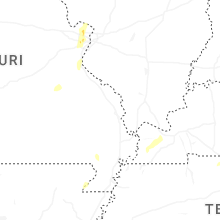
Hail and Wind Damage Spotted on 5/19/2025
Filter by Report Type:Hail ReportsWind Reports
States Impacted
Missouri, Texas, Oklahoma, New Mexico, Nebraska, Kansas, South Carolina, Iowa, South Dakota, Minnesota, Tennessee, Arkansas, IllinoisMissouri
| Local Time | Report Details |
|---|---|
| 8:28 AM CDT | Quarter sized hail reported near Rich Hill, MO, 66.3 miles ENE of Chanute, KS, emergency manager reported quarter hail in rich hill. |
| 2:45 PM CDT | Half Dollar sized hail reported near Kansas City, MO, 17.5 miles NNW of Kansas City, MO, social media report. time estimated from radar. |
| 2:54 PM CDT | Golf Ball sized hail reported near Albany, MO, 79.8 miles N of Kansas City, MO |
| 2:54 PM CDT | Quarter sized hail reported near Smithville, MO, 19.8 miles N of Kansas City, MO, social media report of quarter size hail in smithville. time estimated from radar. |
| 2:54 PM CDT | Hen Egg sized hail reported near Albany, MO, 80.8 miles NNE of Kansas City, MO, social media report of hail slightly larger than golf balls east of albany. time estimated from radar. |
| 2:55 PM CDT | Quarter sized hail reported near Albany, MO, 80.3 miles N of Kansas City, MO, public reported quarter hail. |
| 2:59 PM CDT | Half Dollar sized hail reported near Smithville, MO, 21.9 miles N of Kansas City, MO, social media report. time estimated from radar. |
| 3:08 PM CDT | Half Dollar sized hail reported near Kansas City, MO, 7.6 miles NNE of Kansas City, MO, time estimated from radar. |
| 3:17 PM CDT | Ping Pong Ball sized hail reported near Kansas City, MO, 14.3 miles NNE of Kansas City, MO |
| 3:17 PM CDT | Ping Pong Ball sized hail reported near Hatfield, MO, 81 miles SSW of Des Moines, IA, social media report of ping pong ball size hail south of hatfield. time estimated from radar. |
| 3:17 PM CDT | Quarter sized hail reported near Lathrop, MO, 33.7 miles NNE of Kansas City, MO, social media report. time estimated from radar. |
| 3:20 PM CDT | Quarter sized hail reported near Kansas City, MO, 13 miles NNE of Kansas City, MO, report from mping: quarter (1.00 in.). time confirmed from radar. |
| 3:20 PM CDT | Half Dollar sized hail reported near Kansas City, MO, 14 miles NNE of Kansas City, MO, time confirmed from radar. |
| 3:21 PM CDT | Quarter sized hail reported near Kansas City, MO, 13.2 miles NNE of Kansas City, MO, report from mping: quarter (1.00 in.). time confirmed from radar. |
| 3:21 PM CDT | Half Dollar sized hail reported near Bethany, MO, 89.5 miles SSW of Des Moines, IA, em relayed report of larger than quarter hail near bethany. |
| 3:30 PM CDT | Golf Ball sized hail reported near Kearney, MO, 23.1 miles NNE of Kansas City, MO |
| 3:30 PM CDT | Tennis Ball sized hail reported near Kearney, MO, 22 miles NNE of Kansas City, MO |
| 3:31 PM CDT | Quarter sized hail reported near Bethany, MO, 86.4 miles NNE of Kansas City, MO, multiple social media reports of quarter size hail in the bethany area. time estimated from radar. |
| 3:40 PM CDT | Ping Pong Ball sized hail reported near Holt, MO, 30.7 miles NNE of Kansas City, MO, social media report. time estimated from radar. |
| 3:45 PM CDT | Downed trees near route u near worland. time estimated from rada in bates county MO, 58.7 miles NE of Chanute, KS |
| 3:54 PM CDT | Ping Pong Ball sized hail reported near Kansas City, MO, 0.3 miles SE of Kansas City, MO, report from mping: ping pong ball (1.50 in.). time estimated from radar. |
| 3:54 PM CDT | Golf Ball sized hail reported near Holt, MO, 27.8 miles NNE of Kansas City, MO, social media report and photo of golf ball size hail near holt. time estimated from radar. |
| 3:57 PM CDT | Quarter sized hail reported near Kansas City, MO, 0.3 miles SE of Kansas City, MO |
| 4:03 PM CDT | Hen Egg sized hail reported near Kearney, MO, 22 miles NNE of Kansas City, MO, social media report of two-inch hail in kearney. time estimated from radar. |
| 4:05 PM CDT | Half Dollar sized hail reported near Kearney, MO, 20.8 miles NE of Kansas City, MO |
| 4:08 PM CDT | Half Dollar sized hail reported near Kearney, MO, 24.4 miles NE of Kansas City, MO, social media report. time estimated from radar. |
| 4:12 PM CDT | Social media report of a large tree down at a residence. time estimated from rada in cass county MO, 29.2 miles S of Kansas City, MO |
| 4:12 PM CDT | Quarter sized hail reported near Lawson, MO, 31 miles NE of Kansas City, MO, social media report of quarter size hail near lawson. time estimated from radar. |
| 4:17 PM CDT | Half Dollar sized hail reported near Lawson, MO, 36.4 miles NE of Kansas City, MO, social media report. time estimated from radar. |
| 4:20 PM CDT | Tree downed on hous in cass county MO, 18.1 miles S of Kansas City, MO |
| 4:20 PM CDT | Downed power line due to thunderstorm wind gust in cass county MO, 19.7 miles S of Kansas City, MO |
| 4:21 PM CDT | Multiple reports of trees down with some onto vehicles or houses in the belton area. time estimated from rada in cass county MO, 21 miles S of Kansas City, MO |
| 4:23 PM CDT | Large tree down in the red bridge area. time estimated from rada in jackson county MO, 12 miles S of Kansas City, MO |
| 4:27 PM CDT | Large tree down at a residence. time estimated from rada in jackson county MO, 5.7 miles S of Kansas City, MO |
| 4:27 PM CDT | Downed tree limbs and wires near 57th street. time estimated from rada in platte county MO, 8.8 miles NW of Kansas City, MO |
| 4:27 PM CDT | Multiple reports of downed trees and wires on the south side of kansas city. time estimated from rada in jackson county MO, 1.7 miles SSE of Kansas City, MO |
| 4:29 PM CDT | Storm damage reported in platte county MO, 11.2 miles NNW of Kansas City, MO |
| 4:31 PM CDT | Downed wires and power outages near and south of trenton. time estimated from rada in grundy county MO, 83.5 miles NE of Kansas City, MO |
| 4:33 PM CDT | Tree fell on top of hous in platte county MO, 9.5 miles NNW of Kansas City, MO |
| 4:34 PM CDT | Downed tree limbs and wires tracy avenue. time estimated from radar and dispatch repor in clay county MO, 6.7 miles N of Kansas City, MO |
| 4:36 PM CDT | Downed trees and power poles in the white oak area. time estimated from rada in jackson county MO, 14.8 miles ESE of Kansas City, MO |
| 4:36 PM CDT | Downed tree onto a house. time estimated from rada in platte county MO, 9.3 miles NNW of Kansas City, MO |
| 4:38 PM CDT | Mkc aso in clay county MO, 1.5 miles NW of Kansas City, MO |
| 4:38 PM CDT | Multiple trees down on houses in gladstone. time estimated from rada in clay county MO, 8.1 miles N of Kansas City, MO |
| 4:38 PM CDT | Numerous 2-6 inch diameter tree branches down. as well as smaller trees in genera in clay county MO, 2.2 miles NNE of Kansas City, MO |
| 4:45 PM CDT | Large tree down at a residence. time estimated from rada in clay county MO, 6.8 miles N of Kansas City, MO |
| 4:46 PM CDT | Social media reports and photos of trees and limbs down in independence near the stadiums. time estimated from social media reports and confirmed from rada in jackson county MO, 7.1 miles ESE of Kansas City, MO |
| 4:48 PM CDT | Downed tree and light pole near route 152. time estimated from rada in clay county MO, 10 miles NNE of Kansas City, MO |
| 4:53 PM CDT | Mci aso in platte county MO, 15.1 miles NNW of Kansas City, MO |
| 4:58 PM CDT | Several downed trees on 188th street. time estimated from rada in clay county MO, 22.6 miles N of Kansas City, MO |
| 5:00 PM CDT | Downed wires and power outages near excelsior springs. time estimated from rada in clay county MO, 25 miles NE of Kansas City, MO |
| 5:05 PM CDT | Private weather senso in clay county MO, 21.2 miles N of Kansas City, MO |
| 5:10 PM CDT | Quarter sized hail reported near Nevada, MO, 61.6 miles ENE of Chanute, KS, report from mping... quarter 1.00 in. |
| 5:10 PM CDT | Several social media reports of trees and limbs down in independence. time estimated from rada in jackson county MO, 9.3 miles E of Kansas City, MO |
| 5:14 PM CDT | Social media report of downed tree on county road 465. time estimated from rada in caldwell county MO, 42 miles NNE of Kansas City, MO |
| 5:16 PM CDT | Downed tree on route 131 near route ff. time estimated from rada in lafayette county MO, 32.5 miles E of Kansas City, MO |
| 5:30 PM CDT | Quarter sized hail reported near El Dorado Springs, MO, 63.8 miles NW of Springfield, MO, quarter sized hail on highway 54... 3 miles west of el dorado springs. time based on radar. |
| 5:36 PM CDT | Downed wires and power outages in the hamilton area. time estimated from rada in caldwell county MO, 54.5 miles NE of Kansas City, MO |
| 5:41 PM CDT | 69 mph measured gust at 17:41 hours about 7 miles west southwest of goodma in mcdonald county MO, 76.5 miles WSW of Springfield, MO |
| 6:00 PM CDT | Large trees down. time based on rada in jasper county MO, 64.8 miles SE of Chanute, KS |
| 6:00 PM CDT | Tree damage. time based on rada in newton county MO, 58.6 miles WSW of Springfield, MO |
| 6:00 PM CDT | Roof damage. time based on rada in jasper county MO, 66.4 miles SE of Chanute, KS |
| 6:07 PM CDT | Roof off a garag in jasper county MO, 64 miles W of Springfield, MO |
| 6:10 PM CDT | Large tree dow in jasper county MO, 46.7 miles WSW of Springfield, MO |
| 6:15 PM CDT | Joplin airport aso in jasper county MO, 63.5 miles SE of Chanute, KS |
| 6:18 PM CDT | Few limbs down by driveway... healthy maples 8 to 10 inch diameter. many small limbs and leaves dow in lawrence county MO, 42.1 miles W of Springfield, MO |
| 6:25 PM CDT | Southbound i49 mm 79.8 tractor trailer overturned blocking one lane. time based on rada in barton county MO, 59.8 miles WNW of Springfield, MO |
| 6:40 PM CDT | El do fire is enroute to trees and power lines down 32 highway south of el dorado. time based on rada in cedar county MO, 56.6 miles NW of Springfield, MO |
| 6:42 PM CDT | Tree in middle of hwy zz east of law 1220 marionville in eb lane. time based on rada in lawrence county MO, 24.9 miles SW of Springfield, MO |
| 6:45 PM CDT | Power outage in brownington... lowry city... deepater. many reports of power lines dow in st. clair county MO, 68.4 miles NNW of Springfield, MO |
| 6:45 PM CDT | U highway and 501 south of el dorado springs. time based on radar. pics in slac in cedar county MO, 56.6 miles NW of Springfield, MO |
| 6:48 PM CDT | Road closed due to debris on roadway route u eastbound. time based on rada in cedar county MO, 55.5 miles NW of Springfield, MO |
| 7:00 PM CDT | Roof of barn blocking south bound 13 in lowry city. also reports significant damage. time based on rada in st. clair county MO, 66.2 miles NNW of Springfield, MO |
| 7:10 PM CDT | Iconium missouri fire reporting multiple trees down along hh hwy blocking roadways in multiple places. time based on rada in st. clair county MO, 67.7 miles NNW of Springfield, MO |
| 7:14 PM CDT | Social media report and photos of several trees down at a residence east of deepwater. time estimated from rada in henry county MO, 75.5 miles NNW of Springfield, MO |
| 7:25 PM CDT | Media in the area estimated 70 to 80 mph rfd wind in henry county MO, 74.9 miles SE of Kansas City, MO |
| 7:30 PM CDT | Tree damage in lincoln on highway 65. time based in rada in benton county MO, 66.8 miles SW of Columbia, MO |
| 7:30 PM CDT | Near thibaut boat ramp area trees down and they witnessed what they thought was a tornado with debris alof in benton county MO, 72.7 miles SW of Columbia, MO |
| 7:50 PM CDT | Road closed due to trees. time based on rada in benton county MO, 74.6 miles N of Springfield, MO |
| 7:52 PM CDT | Downed wires and power outages near muschaney road. time estimated from rada in pettis county MO, 46.7 miles WSW of Columbia, MO |
| 8:06 PM CDT | Multiple trees and power lines down. a house fire due to a lightning strike... and just got reports of a machine shop with heavy damage or destroyed near the house fire in morgan county MO, 45.2 miles SW of Columbia, MO |
| 8:14 PM CDT | Downed wires near walnut street. time estimated from rada in cooper county MO, 27.5 miles WSW of Columbia, MO |
| 8:32 PM CDT | Side of industrial building damaged with wall collapse. time estimated from rada in buchanan county MO, 45 miles NNW of Kansas City, MO |
| 8:32 PM CDT | Downed wires and power outages near king hill road. time estimated from rada in buchanan county MO, 43.3 miles NNW of Kansas City, MO |
| 8:36 PM CDT | Social media video of a downed tree on power lines in southeast saint joseph. time estimated from rada in buchanan county MO, 41.2 miles NNW of Kansas City, MO |
| 8:36 PM CDT | Several reports of downed wires and power outages south of st. joseph. time estimated from rada in buchanan county MO, 39.8 miles NNW of Kansas City, MO |
| 8:37 PM CDT | Downed wires and power outages near jefferson road. time estimated from rada in cooper county MO, 21.3 miles W of Columbia, MO |
| 8:38 PM CDT | Quarter sized hail reported near Saint Louis, MO, 12.5 miles W of Saint Louis, MO, report from mping: quarter (1.00 in.). |
| 8:40 PM CDT | Golf Ball sized hail reported near Saint Louis, MO, 12.4 miles WSW of Saint Louis, MO |
| 8:42 PM CDT | Tree down on swan cave. time based on rada in christian county MO, 23.2 miles SE of Springfield, MO |
| 8:45 PM CDT | Quarter sized hail reported near Hazelwood, MO, 13.6 miles NW of Saint Louis, MO |
| 8:48 PM CDT | Several reports of downed wires and power outages between amazonia and forbes. time estimated from rada in andrew county MO, 56.9 miles NNW of Kansas City, MO |
| 8:49 PM CDT | Downed trees in the easton area. time estimated from rada in buchanan county MO, 42.7 miles N of Kansas City, MO |
| 8:50 PM CDT | Golf Ball sized hail reported near Saint Ann, MO, 12 miles NW of Saint Louis, MO |
| 8:56 PM CDT | Multiple reports of tree limbs and wires down east of easton. time estimated from rada in clinton county MO, 42.6 miles N of Kansas City, MO |
| 8:57 PM CDT | Half Dollar sized hail reported near Hazelwood, MO, 14.5 miles NW of Saint Louis, MO |
| 8:58 PM CDT | Half Dollar sized hail reported near Hazelwood, MO, 14.5 miles NW of Saint Louis, MO |
| 8:58 PM CDT | Ping Pong Ball sized hail reported near Saint Louis, MO, 11 miles NW of Saint Louis, MO |
| 9:00 PM CDT | Quarter sized hail reported near Florissant, MO, 13.6 miles NNW of Saint Louis, MO |
| 9:00 PM CDT | Tree down. time based on rada in douglas county MO, 39.7 miles ESE of Springfield, MO |
| 9:00 PM CDT | Tree on road. modot on way to clear. time based on rada in douglas county MO, 35.4 miles SE of Springfield, MO |
| 9:01 PM CDT | Hen Egg sized hail reported near Florissant, MO, 14.4 miles NNW of Saint Louis, MO, observer estimated wind gusts around 40 mph. |
| 9:06 PM CDT | Tree down on 14 hwy. time based on rada in douglas county MO, 39.7 miles ESE of Springfield, MO |
| 9:20 PM CDT | Tree down on c highway north of skyline. time based on rada in douglas county MO, 49.3 miles ESE of Springfield, MO |
| 9:26 PM CDT | Private weather senso in clinton county MO, 40.4 miles NNE of Kansas City, MO |
| 9:36 PM CDT | Tree down across the road. time estimated from rada in douglas county MO, 60.8 miles SSW of Salem, MO |
| 10:00 PM CDT | Two trees down on state highway 17 near gaston road intersection. multiple power poles down as wel in texas county MO, 29.9 miles SSW of Salem, MO |
| 10:20 PM CDT | Trees and branches down on cr5080 and highway 19 south of salem. time estimated by rada in dent county MO, 1.9 miles S of Salem, MO |
| 10:20 PM CDT | Trees down 3-4 miles south of sale in dent county MO, 3.2 miles S of Salem, MO |
| 10:24 PM CDT | Tree down on highway 8. time estimated from rada in phelps county MO, 22.4 miles N of Salem, MO |
| 10:35 PM CDT | Tree down about 10 miles east of salem on highway 3 in dent county MO, 10.2 miles E of Salem, MO |
| 1:05 AM CDT | Multiple trees/branches down in cape girardeau and jackso in cape girardeau county MO, 5.7 miles NW of Cape Girardeau, MO |
Texas
| Local Time | Report Details |
|---|---|
| 9:53 AM CDT | Ping Pong Ball sized hail reported near Lorena, TX, 35.9 miles ENE of Killeen, TX, social media picture of ping pong ball size hail in lorena relayed via broadcast media. time estimated from radar. |
| 9:57 AM CDT | Half Dollar sized hail reported near Lorena, TX, 38.2 miles ENE of Killeen, TX, half dollar size hail northeast of lorena relayed via broadcast media. time estimated from radar. |
| 2:24 PM CDT | Quarter sized hail reported near Henrietta, TX, 19.4 miles ESE of Wichita Falls, TX, report from mping: quarter (1.00 in.). |
| 2:24 PM CDT | Tea Cup sized hail reported near Henrietta, TX, 20.8 miles SE of Wichita Falls, TX, report from mping: tea cup (3.00 in.). |
| 2:35 PM CDT | Golf Ball sized hail reported near Henrietta, TX, 20.8 miles SE of Wichita Falls, TX, relayed through nwschat. |
| 3:00 PM CDT | Half Dollar sized hail reported near Ringgold, TX, 33.8 miles ESE of Wichita Falls, TX, report from mping: half dollar (1.25 in.). |
| 3:01 PM CDT | Golf Ball sized hail reported near Ringgold, TX, 32.8 miles E of Wichita Falls, TX |
| 3:18 PM CDT | Golf Ball sized hail reported near Henrietta, TX, 22.6 miles SE of Wichita Falls, TX |
| 3:42 PM CDT | Hen Egg sized hail reported near Ringgold, TX, 32 miles ESE of Wichita Falls, TX, report from mping: hen egg (2.00 in.). |
| 4:01 PM CDT | Ping Pong Ball sized hail reported near Bowie, TX, 44.5 miles ESE of Wichita Falls, TX, ping pong ball sized hail in bowie. |
| 4:02 PM CDT | Quarter sized hail reported near Bowie, TX, 44.5 miles ESE of Wichita Falls, TX, report from mping: quarter (1.00 in.). |
| 4:18 PM CDT | Golf Ball sized hail reported near Montague, TX, 47.9 miles ESE of Wichita Falls, TX, golf ball sized hail in montague. |
| 4:19 PM CDT | Golf Ball sized hail reported near Montague, TX, 47 miles ESE of Wichita Falls, TX, report from mping: golf ball (1.75 in.). |
| 4:20 PM CDT | Golf Ball sized hail reported near Montague, TX, 48.4 miles ESE of Wichita Falls, TX, report from mping: golf ball (1.75 in.). |
| 4:24 PM CDT | Ping Pong Ball sized hail reported near Bowie, TX, 44.1 miles ESE of Wichita Falls, TX, report from mping: ping pong ball (1.50 in.). |
| 4:28 PM CDT | Golf Ball sized hail reported near Nocona, TX, 48.9 miles E of Wichita Falls, TX, golf ball sized hail 4 east of nocona. |
| 4:32 PM CDT | Quarter sized hail reported near Nocona, TX, 50.1 miles E of Wichita Falls, TX, quarter sized hail and high winds in spanish fort. |
| 4:34 PM CDT | Softball sized hail reported near Saint Jo, TX, 56.9 miles E of Wichita Falls, TX, 4.5 inch diameter hail 7 miles north of saint jo. |
| 5:42 PM CDT | Mesonet station 44 mclean 1e.. in gray county TX, 59.5 miles NNW of Childress, TX |
| 5:56 PM CDT | Baseball sized hail reported near Saint Jo, TX, 56.4 miles ESE of Wichita Falls, TX, baseball sized hail on highway 82 west of saint jo. |
| 5:57 PM CDT | Grapefruit sized hail reported near Saint Jo, TX, 54.9 miles ESE of Wichita Falls, TX, softball sized hail 4 miles northwest of saint jo. |
| 6:02 PM CDT | Quarter sized hail reported near Saint Jo, TX, 58.4 miles E of Wichita Falls, TX, report from mping: quarter (1.00 in.). |
| 6:07 PM CDT | Grapefruit sized hail reported near Saint Jo, TX, 57.5 miles E of Wichita Falls, TX, report from mping: grapefruit (4.00 in.). |
| 6:13 PM CDT | Tennis Ball sized hail reported near Muenster, TX, 62 miles E of Wichita Falls, TX, golf ball to tennis ball sized hail 10 miles n of muenster near bulcher. |
| 6:14 PM CDT | Golf Ball sized hail reported near Saint Jo, TX, 58.2 miles ESE of Wichita Falls, TX, golf ball sized hail in saint jo. |
| 6:23 PM CDT | Two overhead doors damaged by high winds at vfd 1 mile south of bowie on hwy 5 in montague county TX, 44.4 miles ESE of Wichita Falls, TX |
| 6:25 PM CDT | Golf Ball sized hail reported near Saint Jo, TX, 57.6 miles ESE of Wichita Falls, TX |
| 6:50 PM CDT | Hen Egg sized hail reported near Bowie, TX, 49.2 miles SE of Wichita Falls, TX, 2 inch hail reported in fruitland. |
| 6:52 PM CDT | Mesonet station whrt2 wheeler raw in wheeler county TX, 70.4 miles N of Childress, TX |
| 6:52 PM CDT | Mesonet station 119 palo duro reservoir 1n in hansford county TX, 87.6 miles NNE of Amarillo, TX |
| 6:56 PM CDT | Power line blown down onto a house on just north of lawhorn lane and hwy 287 north of sunse in montague county TX, 51 miles SE of Wichita Falls, TX |
| 6:57 PM CDT | Half Dollar sized hail reported near Sunset, TX, 52.6 miles SE of Wichita Falls, TX, social media photo showed half dollar size hail in sunset. |
| 7:35 PM CDT | Awos station ke42 1 nnw spearma in hansford county TX, 78.4 miles NNE of Amarillo, TX |
| 7:39 PM CDT | Corrects previous tstm wnd gst report from 9 nw waka. mesonet station 119 palo duro reservoir 1n in hansford county TX, 87.6 miles NNE of Amarillo, TX |
| 8:09 PM CDT | Quarter sized hail reported near Lindsay, TX, 62.6 miles NNW of Dallas, TX, quarter sized hail just west of gainesville. |
| 8:10 PM CDT | Storm damage reported in cooke county TX, 62.8 miles NNW of Dallas, TX |
| 8:15 PM CDT | Several tree limbs blown down across gainesvill in cooke county TX, 62.8 miles NNW of Dallas, TX |
| 8:15 PM CDT | Measured on roof of county courthouse at an elevation of 30 fee in cooke county TX, 61.5 miles NNW of Dallas, TX |
| 8:20 PM CDT | Corrects previous tstm wnd gst report from 1 nnw spearman. awos station ke42 1 nnw spearma in hansford county TX, 78.4 miles NNE of Amarillo, TX |
| 8:25 PM CDT | Quarter sized hail reported near Gainesville, TX, 66.2 miles N of Dallas, TX, report from mping: quarter (1.00 in.). |
| 8:42 PM CDT | Quarter sized hail reported near Denison, TX, 50.7 miles SSW of Atoka, OK, report from mping: quarter (1.00 in.). |
| 8:47 PM CDT | Quarter sized hail reported near Denison, TX, 49.5 miles SSW of Atoka, OK, report from mping: quarter (1.00 in.). |
| 8:50 PM CDT | Quarter sized hail reported near Denison, TX, 46.7 miles SSW of Atoka, OK, nickel to quarter size hail in carpenders bluff. |
| 8:53 PM CDT | Quarter sized hail reported near Denison, TX, 49.7 miles SSW of Atoka, OK, report from mping: quarter (1.00 in.). |
| 12:10 AM CDT | Kft in tarrant county TX, 33 miles W of Dallas, TX |
| 12:11 AM CDT | Knf in tarrant county TX, 36.9 miles W of Dallas, TX |
| 12:22 AM CDT | Kft in tarrant county TX, 33 miles W of Dallas, TX |
| 1:35 AM CDT | Kf4 in rockwall county TX, 23.2 miles ENE of Dallas, TX |
Oklahoma
| Local Time | Report Details |
|---|---|
| 12:21 PM CDT | Half Dollar sized hail reported near Noble, OK, 27.4 miles SSE of Oklahoma City, OK, report from mping: half dollar (1.25 in.). |
| 12:21 PM CDT | Quarter sized hail reported near Noble, OK, 27.2 miles SSE of Oklahoma City, OK, report at 108th and maguire road. time is radar estimated. |
| 2:12 PM CDT | Golf Ball sized hail reported near Sulphur, OK, 49.9 miles W of Atoka, OK |
| 2:12 PM CDT | Hen Egg sized hail reported near Sulphur, OK, 50.3 miles W of Atoka, OK, report from mping: hen egg (2.00 in.). |
| 2:13 PM CDT | Quarter sized hail reported near Sulphur, OK, 48.4 miles WNW of Atoka, OK, report from mping: quarter (1.00 in.). |
| 2:15 PM CDT | Golf Ball sized hail reported near Sulphur, OK, 50 miles W of Atoka, OK |
| 2:28 PM CDT | Quarter sized hail reported near Allen, OK, 36.4 miles NNW of Atoka, OK, nwschat report. |
| 2:31 PM CDT | Quarter sized hail reported near Ada, OK, 45.6 miles NW of Atoka, OK, nwschat report. |
| 2:36 PM CDT | Quarter sized hail reported near Ada, OK, 48.7 miles WNW of Atoka, OK, report from mping: quarter (1.00 in.). |
| 2:37 PM CDT | Half Dollar sized hail reported near Holdenville, OK, 44.9 miles N of Atoka, OK, report from mping: half dollar (1.25 in.). |
| 2:56 PM CDT | Ping Pong Ball sized hail reported near Ada, OK, 40.3 miles NW of Atoka, OK, spotternetwork report. |
| 2:56 PM CDT | Spotternetwork repor in pontotoc county OK, 40.3 miles NW of Atoka, OK |
| 3:13 PM CDT | Ping Pong Ball sized hail reported near Okemah, OK, 52.5 miles SSW of Tulsa, OK |
| 3:17 PM CDT | Golf Ball sized hail reported near Seminole, OK, 51.9 miles ESE of Oklahoma City, OK |
| 3:28 PM CDT | Tree down in road. approximately 8 inch in diamete in hughes county OK, 41.4 miles NNW of Atoka, OK |
| 3:29 PM CDT | Hen Egg sized hail reported near Seminole, OK, 50.3 miles ESE of Oklahoma City, OK, photo in nwschat. |
| 3:38 PM CDT | Quarter sized hail reported near Marlow, OK, 59.8 miles NNE of Wichita Falls, TX, aw. |
| 3:41 PM CDT | Ping Pong Ball sized hail reported near Marlow, OK, 59.8 miles NNE of Wichita Falls, TX, aw. |
| 3:48 PM CDT | Quarter sized hail reported near Mounds, OK, 19 miles SSW of Tulsa, OK |
| 3:50 PM CDT | Quarter sized hail reported near Tulsa, OK, 10.7 miles SSE of Tulsa, OK |
| 3:52 PM CDT | Quarter sized hail reported near Tulsa, OK, 7.4 miles SSE of Tulsa, OK, nickel to quarter size hail at 71st and yale. |
| 3:53 PM CDT | Quarter sized hail reported near Jenks, OK, 9 miles S of Tulsa, OK |
| 3:55 PM CDT | Half Dollar sized hail reported near Jenks, OK, 8.4 miles S of Tulsa, OK |
| 3:56 PM CDT | Quarter sized hail reported near Broken Arrow, OK, 11 miles ESE of Tulsa, OK |
| 3:56 PM CDT | Golf Ball sized hail reported near Tulsa, OK, 7.1 miles SSE of Tulsa, OK |
| 3:56 PM CDT | Golf Ball sized hail reported near Wilson, OK, 63.2 miles ENE of Wichita Falls, TX, along highway 76 and to the north towards town. |
| 3:57 PM CDT | Quarter sized hail reported near Sapulpa, OK, 9.7 miles S of Tulsa, OK |
| 3:57 PM CDT | Golf Ball sized hail reported near Tulsa, OK, 5.2 miles SSE of Tulsa, OK |
| 3:57 PM CDT | Hen Egg sized hail reported near Tulsa, OK, 7.1 miles SSE of Tulsa, OK |
| 3:58 PM CDT | Quarter sized hail reported near Bixby, OK, 12.6 miles S of Tulsa, OK |
| 3:59 PM CDT | Half Dollar sized hail reported near Tulsa, OK, 3 miles SSE of Tulsa, OK |
| 4:00 PM CDT | Quarter sized hail reported near Bixby, OK, 13.3 miles S of Tulsa, OK |
| 4:00 PM CDT | Quarter sized hail reported near Tulsa, OK, 3.7 miles SSE of Tulsa, OK |
| 4:00 PM CDT | Half Dollar sized hail reported near Tulsa, OK, 6.5 miles ESE of Tulsa, OK |
| 4:00 PM CDT | Ping Pong Ball sized hail reported near Tulsa, OK, 8.8 miles ESE of Tulsa, OK |
| 4:01 PM CDT | Half Dollar sized hail reported near Tulsa, OK, 1.9 miles SE of Tulsa, OK |
| 4:01 PM CDT | Ping Pong Ball sized hail reported near Tulsa, OK, 3.6 miles ENE of Tulsa, OK |
| 4:02 PM CDT | Half Dollar sized hail reported near Tulsa, OK, 2.4 miles E of Tulsa, OK |
| 4:03 PM CDT | Golf Ball sized hail reported near Tulsa, OK, 9.8 miles ESE of Tulsa, OK |
| 4:04 PM CDT | Quarter sized hail reported near Tulsa, OK, 6.7 miles ENE of Tulsa, OK |
| 4:06 PM CDT | Quarter sized hail reported near Lone Grove, OK, 66.3 miles WSW of Atoka, OK, reported at lone grove city hall. |
| 4:06 PM CDT | Half Dollar sized hail reported near Tulsa, OK, 3.7 miles SE of Tulsa, OK |
| 4:06 PM CDT | Measured thunderstorm wind gust of 64 mph at the tulsa aso in tulsa county OK, 7.2 miles ENE of Tulsa, OK |
| 4:08 PM CDT | Quarter sized hail reported near Tulsa, OK, 7.5 miles E of Tulsa, OK, national weather service office @ 11th and highway 169. |
| 4:10 PM CDT | Quarter sized hail reported near Owasso, OK, 12.2 miles NE of Tulsa, OK |
| 4:11 PM CDT | Quarter sized hail reported near Owasso, OK, 13.2 miles NE of Tulsa, OK |
| 4:11 PM CDT | Ping Pong Ball sized hail reported near Skiatook, OK, 13.8 miles N of Tulsa, OK |
| 4:11 PM CDT | Ping Pong Ball sized hail reported near Owasso, OK, 15.3 miles ENE of Tulsa, OK |
| 4:12 PM CDT | Quarter sized hail reported near Skiatook, OK, 13.8 miles N of Tulsa, OK |
| 4:12 PM CDT | Quarter sized hail reported near Tulsa, OK, 4.1 miles ESE of Tulsa, OK, quarter size hail lasting approximately 4 minutes. leaves ripped off trees. |
| 4:12 PM CDT | Half Dollar sized hail reported near Owasso, OK, 11.9 miles NE of Tulsa, OK |
| 4:13 PM CDT | Half Dollar sized hail reported near Owasso, OK, 13.2 miles NE of Tulsa, OK |
| 4:13 PM CDT | Quarter sized hail reported near Tulsa, OK, 4.6 miles ESE of Tulsa, OK, report of golf ball hail and tree limbs down at 31st and yale. |
| 4:15 PM CDT | Quarter sized hail reported near Owasso, OK, 16.2 miles NE of Tulsa, OK |
| 4:17 PM CDT | Quarter sized hail reported near Claremore, OK, 17.8 miles ENE of Tulsa, OK |
| 4:17 PM CDT | Golf Ball sized hail reported near Ravia, OK, 37.5 miles WSW of Atoka, OK, reported at fire department. |
| 4:22 PM CDT | Quarter sized hail reported near Skiatook, OK, 18.3 miles N of Tulsa, OK |
| 4:23 PM CDT | Quarter sized hail reported near Blanchard, OK, 27.9 miles SSW of Oklahoma City, OK |
| 4:26 PM CDT | Ping Pong Ball sized hail reported near Owasso, OK, 14.2 miles NE of Tulsa, OK, report from mping: ping pong ball (1.50 in.). |
| 4:27 PM CDT | Golf Ball sized hail reported near Tulsa, OK, 5.6 miles ENE of Tulsa, OK |
| 4:28 PM CDT | Ping Pong Ball sized hail reported near Collinsville, OK, 16.9 miles NNE of Tulsa, OK, lots of quarter to ping pong hail observed. |
| 4:28 PM CDT | Quarter sized hail reported near Owasso, OK, 16 miles NE of Tulsa, OK |
| 4:36 PM CDT | Quarter sized hail reported near Newcastle, OK, 16 miles SSW of Oklahoma City, OK, reported on highway 76. |
| 4:40 PM CDT | Measured at ok mesonet sit in pontotoc county OK, 35.1 miles WNW of Atoka, OK |
| 4:45 PM CDT | Quarter sized hail reported near Oklahoma City, OK, 9.3 miles SSW of Oklahoma City, OK, estimated 55 mph wind gust as well. |
| 4:45 PM CDT | Quarter sized hail reported near Oklahoma City, OK, 9.3 miles S of Oklahoma City, OK |
| 4:45 PM CDT | Quarter sized hail reported near Bartlesville, OK, 41.3 miles NNE of Tulsa, OK |
| 4:46 PM CDT | Along highway 3w between stonewall and ahlos in pontotoc county OK, 33.7 miles NW of Atoka, OK |
| 4:48 PM CDT | Tree down in roadway at cr 3 drive and cr3580... time is radar estimat in pontotoc county OK, 38.1 miles NW of Atoka, OK |
| 4:49 PM CDT | Baseball sized hail reported near Leon, OK, 61.5 miles E of Wichita Falls, TX, on highway 76 just south of 32. |
| 4:49 PM CDT | X photo with measuremen in pontotoc county OK, 36.8 miles NW of Atoka, OK |
| 4:52 PM CDT | Delayed report. kok in oklahoma county OK, 7.2 miles SW of Oklahoma City, OK |
| 4:54 PM CDT | Quarter sized hail reported near Burneyville, OK, 66.7 miles E of Wichita Falls, TX, delayed report. report from mping: quarter (1.00 in.). |
| 4:55 PM CDT | Measured thunderstorm wind gust of 62 mph at the copan mesone in washington county OK, 52.7 miles N of Tulsa, OK |
| 4:58 PM CDT | Tree debris with tree on roadway on cr 1475. time is radar estimat in seminole county OK, 40.2 miles NNW of Atoka, OK |
| 5:02 PM CDT | Quarter sized hail reported near Oklahoma City, OK, 4.3 miles NE of Oklahoma City, OK |
| 5:13 PM CDT | Report of trees down in south coffeyvill in nowata county OK, 48.6 miles S of Chanute, KS |
| 5:15 PM CDT | Trees downed onto powerlines off of mill street in ravi in johnston county OK, 37.5 miles WSW of Atoka, OK |
| 5:18 PM CDT | Ping Pong Ball sized hail reported near Arcadia, OK, 19.1 miles NNE of Oklahoma City, OK, photo sent to eoc in edmond. |
| 5:20 PM CDT | Quarter sized hail reported near Ada, OK, 43.3 miles NW of Atoka, OK, x post with photo. |
| 5:21 PM CDT | Golf Ball sized hail reported near Guthrie, OK, 21.6 miles NNE of Oklahoma City, OK, reported through mping. |
| 5:27 PM CDT | Half Dollar sized hail reported near Coyle, OK, 32.6 miles NNE of Oklahoma City, OK |
| 5:37 PM CDT | Quarter sized hail reported near Coalgate, OK, 15.5 miles N of Atoka, OK, report from mping: quarter (1.00 in.). |
| 5:41 PM CDT | Shingles blew off a hous in logan county OK, 36.5 miles NNE of Oklahoma City, OK |
| 5:41 PM CDT | Quarter sized hail reported near Coyle, OK, 36.5 miles NNE of Oklahoma City, OK |
| 5:49 PM CDT | Golf Ball sized hail reported near Coyle, OK, 36.5 miles NNE of Oklahoma City, OK, nwschat report... mainly pea sized hail with some golfballs. |
| 5:53 PM CDT | Thunderstorm wind gust estimated to 60 mph at 428 and 630rd in chotea in mayes county OK, 33.9 miles E of Tulsa, OK |
| 5:56 PM CDT | Golf Ball sized hail reported near Stillwater, OK, 48.2 miles NNE of Oklahoma City, OK |
| 6:15 PM CDT | Half Dollar sized hail reported near Morrison, OK, 62.2 miles WNW of Tulsa, OK, report from mping: half dollar (1.25 in.). |
| 6:30 PM CDT | A measured thunderstorm wind gust occurred at the webbers falls mesone in muskogee county OK, 42.2 miles WNW of Fort Smith, AR |
| 6:35 PM CDT | Measured thunderstorm wind gust of 58 mph at the wilburton mesone in latimer county OK, 57.6 miles NE of Atoka, OK |
| 6:45 PM CDT | Half Dollar sized hail reported near Kaw City, OK, 62.4 miles NW of Tulsa, OK, report from mping: half dollar (1.25 in.). |
| 6:46 PM CDT | Half Dollar sized hail reported near Burbank, OK, 57.1 miles NW of Tulsa, OK |
| 6:47 PM CDT | Quarter sized hail reported near Marietta, OK, 66.7 miles WSW of Atoka, OK, report from mping: quarter (1.00 in.). |
| 6:48 PM CDT | Trained spotter measured thunderstorm wind gust to 64 mph at us highway 60 near intersection with highway 1 in osage county OK, 55.9 miles NW of Tulsa, OK |
| 7:16 PM CDT | Relayed through nwscha in johnston county OK, 26.8 miles SW of Atoka, OK |
| 7:18 PM CDT | Quarter sized hail reported near Spiro, OK, 14.2 miles SW of Fort Smith, AR |
| 7:20 PM CDT | Mesonet station good goodwel in texas county OK, 96.9 miles N of Amarillo, TX |
| 7:37 PM CDT | Quarter sized hail reported near Spiro, OK, 14.2 miles SW of Fort Smith, AR |
| 11:11 PM CDT | Quarter sized hail reported near Ada, OK, 41.1 miles NW of Atoka, OK, phone call report. |
| 11:30 PM CDT | Trees downed on wheeler road northwest of valiant... oklahom in mccurtain county OK, 61.4 miles ESE of Atoka, OK |
| 11:56 PM CDT | Near intersection of us hwy 70 and kirsey r in bryan county OK, 33 miles SW of Atoka, OK |
| 12:10 AM CDT | Multiple trees down around town. some blocking roadways. time estimate in bryan county OK, 30.5 miles SSW of Atoka, OK |
| 12:11 AM CDT | Near washington ave and mockingbird lan in bryan county OK, 28.8 miles SSW of Atoka, OK |
| 12:15 AM CDT | Delayed report. trees and power lines blown down across portions of southern atoka county. location is approximate and time is estimated from rada in atoka county OK, 11.2 miles SSE of Atoka, OK |
| 12:20 AM CDT | Multiple trees down. time estimate in bryan county OK, 40.5 miles SSW of Atoka, OK |
| 1:45 AM CDT | Measured by mesonet statio in choctaw county OK, 42.1 miles SE of Atoka, OK |
| 2:30 AM CDT | Trees down just north of the intersection of state highway 98 and state highway 3 in mccurtain county OK, 68.1 miles W of Nashville, AR |
| 3:00 AM CDT | *** 1 inj *** tree fell on a home in the holly creek area. one occupant cut her head while exiting the home. all other occupants were saf in mccurtain county OK, 55.9 miles W of Nashville, AR |
New Mexico
| Local Time | Report Details |
|---|---|
| 12:12 PM MDT | Asos station kcqc clines corners 1 ss in torrance county NM, 55.8 miles E of Albuquerque, NM |
| 12:40 PM MDT | Mesonet station svan5 se vaugh in guadalupe county NM, 81.4 miles NNW of Roswell, NM |
| 1:37 PM MDT | Corrects previous tstm wnd dmg report from corrales. wind gusts of around 50 mph from showers resulted in a downed tree on a property fence in an alleywa in sandoval county NM, 10.9 miles N of Albuquerque, NM |
| 1:37 PM MDT | Corrects previous tstm wnd dmg report from 1 ssw corrales. small branches down on a ditch dirt road between ranchitos road and coronado roa in sandoval county NM, 9.4 miles N of Albuquerque, NM |
| 1:37 PM MDT | Wind gusts of around 50 mph from showers resulted in a down tree on corrales road near mountain view roa in sandoval county NM, 12.4 miles NNE of Albuquerque, NM |
| 1:37 PM MDT | Wind gusts of around 50 mph from showers resulted in branches down along mariquita road in corrale in sandoval county NM, 10.4 miles NNE of Albuquerque, NM |
| 2:36 PM MDT | Asos station kcqc clines corners 1 ss in torrance county NM, 55.8 miles E of Albuquerque, NM |
| 3:05 PM MDT | Mesonet station svan5 se vaugh in guadalupe county NM, 81.4 miles NNW of Roswell, NM |
| 3:11 PM MDT | Mesonet station up426 vaughn 4 e (upr in guadalupe county NM, 89.3 miles WSW of Tucumcari, NM |
| 3:15 PM MDT | Mesonet station tccn5 thompson cattl in guadalupe county NM, 73 miles W of Tucumcari, NM |
| 4:05 PM MDT | Corrected report for mesonet station ftsn5 east fort sumne in de baca county NM, 56.1 miles SSW of Tucumcari, NM |
Nebraska
| Local Time | Report Details |
|---|---|
| 2:42 PM CDT | Quarter sized hail reported near Fullerton, NE, 35.7 miles NNE of Grand Island, NE, at least quarter size hail. |
| 2:55 PM CDT | Golf Ball sized hail reported near Central City, NE, 22.3 miles NE of Grand Island, NE, spotter reports golf ball sized hail in central city. |
| 4:02 PM CDT | Golf Ball sized hail reported near Osceola, NE, 40.6 miles ENE of Grand Island, NE, spotter reports golf ball sized hail northwest of stromsburg. |
| 4:02 PM CDT | Quarter sized hail reported near Deweese, NE, 41 miles SSE of Grand Island, NE, emergency manager reports quarter sized hail in deweese. |
| 4:05 PM CDT | Quarter sized hail reported near Osceola, NE, 44.9 miles ENE of Grand Island, NE, co-op observer reports quarter sized hail. lasted approximately five minutes. |
| 4:06 PM CDT | Ping Pong Ball sized hail reported near Fairfield, NE, 39.5 miles SSE of Grand Island, NE, half dollar sized hail report 4 miles south of fairfield. |
| 4:07 PM CDT | Ping Pong Ball sized hail reported near Edgar, NE, 42.9 miles SSE of Grand Island, NE, emergency manager reports ping pong ball sized hail in edgar. |
| 4:08 PM CDT | Hen Egg sized hail reported near Edgar, NE, 42.3 miles SSE of Grand Island, NE, photo on social media of 2 inch diameter hail. time estimated from radar. |
| 4:08 PM CDT | Baseball sized hail reported near Edgar, NE, 42.3 miles SSE of Grand Island, NE, report from media of hail up to baseball size in edgar. |
| 4:22 PM CDT | Golf Ball sized hail reported near Fairfield, NE, 36.1 miles SSE of Grand Island, NE, emergency manager reports golf ball size hail near fairfield. |
| 4:23 PM CDT | Golf Ball sized hail reported near Shelby, NE, 57.2 miles ENE of Grand Island, NE |
| 4:23 PM CDT | Semi truck blown ove in platte county NE, 65.8 miles NE of Grand Island, NE |
| 4:24 PM CDT | Quarter sized hail reported near Columbus, NE, 61.8 miles NE of Grand Island, NE |
| 4:27 PM CDT | Half Dollar sized hail reported near Columbus, NE, 62.4 miles ENE of Grand Island, NE |
| 4:30 PM CDT | Tea Cup sized hail reported near Columbus, NE, 64.5 miles ENE of Grand Island, NE |
| 4:38 PM CDT | Golf Ball sized hail reported near Columbus, NE, 66.6 miles ENE of Grand Island, NE |
| 4:39 PM CDT | Quarter sized hail reported near Columbus, NE, 66.5 miles ENE of Grand Island, NE |
| 4:40 PM CDT | Golf Ball sized hail reported near Columbus, NE, 67.5 miles ENE of Grand Island, NE |
| 4:40 PM CDT | Measured on personal weather statio in platte county NE, 64.6 miles ENE of Grand Island, NE |
| 4:45 PM CDT | Quarter sized hail reported near Columbus, NE, 67.3 miles WNW of Omaha, NE |
| 4:56 PM CDT | Half Dollar sized hail reported near Schuyler, NE, 64.8 miles W of Omaha, NE, report from mping: half dollar (1.25 in.). |
| 5:04 PM CDT | Ping Pong Ball sized hail reported near Schuyler, NE, 62.7 miles WNW of Omaha, NE |
| 5:23 PM CDT | Half Dollar sized hail reported near Pawnee City, NE, 63.1 miles NNE of Manhattan, KS, report from mping: half dollar (1.25 in.). |
| 5:39 PM CDT | Golf Ball sized hail reported near North Bend, NE, 50.5 miles WNW of Omaha, NE |
| 6:05 PM CDT | 50 to 60 mph wind and pea size hai in butler county NE, 51.5 miles W of Omaha, NE |
| 6:06 PM CDT | Golf Ball sized hail reported near Scribner, NE, 45.8 miles WNW of Omaha, NE |
| 6:16 PM CDT | Quarter sized hail reported near Humboldt, NE, 70 miles NNE of Manhattan, KS |
| 6:20 PM CDT | Golf Ball sized hail reported near Hooper, NE, 39.4 miles NW of Omaha, NE, report from mping: golf ball (1.75 in.). |
| 6:27 PM CDT | Measured on personal weather statio in dodge county NE, 37.1 miles WNW of Omaha, NE |
| 6:30 PM CDT | Golf Ball sized hail reported near Hooper, NE, 40.2 miles NW of Omaha, NE |
| 7:20 PM CDT | Quarter sized hail reported near Lincoln, NE, 50.4 miles SW of Omaha, NE |
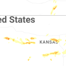
Kansas
| Local Time | Report Details |
|---|---|
| 2:46 PM CDT | Quarter sized hail reported near Humboldt, KS, 9.3 miles NNE of Chanute, KS |
| 2:48 PM CDT | Multiple large trees down over nw belleview rd and nw 110th in cherokee county. time based on radar estimat in cherokee county KS, 38.3 miles SE of Chanute, KS |
| 2:50 PM CDT | Reports of multiple large trees down in crawford county... near mccune and walnut. time based on rada in crawford county KS, 33 miles SE of Chanute, KS |
| 2:50 PM CDT | Power outages reported in crawford county county by heartland rural electric coo in crawford county KS, 45.3 miles ESE of Chanute, KS |
| 2:50 PM CDT | Power outages reported in northern cherokee county by heartland rural electric coo in cherokee county KS, 45 miles SE of Chanute, KS |
| 2:58 PM CDT | Half Dollar sized hail reported near Iola, KS, 17.3 miles NNE of Chanute, KS |
| 2:59 PM CDT | Quarter sized hail reported near La Harpe, KS, 18.4 miles NNE of Chanute, KS |
| 3:00 PM CDT | Reports of multiple large trees down in crawford county... near mccune and walnut. time based on rada in crawford county KS, 21.2 miles ESE of Chanute, KS |
| 3:01 PM CDT | Off duty ff reporting 60 mph winds 5 mi nne of mccun in crawford county KS, 31.2 miles SE of Chanute, KS |
| 3:03 PM CDT | Quarter sized hail reported near Kincaid, KS, 29.8 miles NNE of Chanute, KS |
| 3:12 PM CDT | Quarter sized hail reported near Garnett, KS, 43.5 miles NNE of Chanute, KS |
| 3:20 PM CDT | Power outages reported by heartland rural electric coo in bourbon county KS, 30.6 miles ENE of Chanute, KS |
| 3:36 PM CDT | Quarter sized hail reported near Riley, KS, 16.6 miles WNW of Manhattan, KS, at riley county grade school. |
| 3:38 PM CDT | Quarter sized hail reported near Riley, KS, 16.6 miles WNW of Manhattan, KS, quarter size hail at grade school in riley. |
| 3:40 PM CDT | Golf Ball sized hail reported near Edgerton, KS, 32.5 miles SW of Kansas City, MO |
| 3:42 PM CDT | Storm damage reported in linn county KS, 54.9 miles NE of Chanute, KS |
| 3:45 PM CDT | Downed wires near 2300 road. time estimated from rada in linn county KS, 52.6 miles SSW of Kansas City, MO |
| 3:48 PM CDT | Half Dollar sized hail reported near Overland Park, KS, 12.3 miles SSW of Kansas City, MO |
| 3:49 PM CDT | Quarter sized hail reported near Overland Park, KS, 13.2 miles SSW of Kansas City, MO, dot relayed picture of hail to around quarter size. |
| 3:49 PM CDT | Quarter sized hail reported near Mission, KS, 7.6 miles SSW of Kansas City, MO, report from mping: quarter (1.00 in.). time confirmed from radar. |
| 3:50 PM CDT | Golf Ball sized hail reported near Lenexa, KS, 13.7 miles SW of Kansas City, MO |
| 3:52 PM CDT | Quarter sized hail reported near Basehor, KS, 19.3 miles W of Kansas City, MO |
| 3:52 PM CDT | Golf Ball sized hail reported near Lenexa, KS, 14.1 miles SW of Kansas City, MO |
| 3:53 PM CDT | Em relayed a spotter reported measured wind gust to 63 mp in johnson county KS, 16.9 miles SSW of Kansas City, MO |
| 3:54 PM CDT | Quarter sized hail reported near Overland Park, KS, 10.7 miles SW of Kansas City, MO, report from mping: quarter (1.00 in.). time estimated from radar. |
| 3:54 PM CDT | Ping Pong Ball sized hail reported near Lenexa, KS, 14.1 miles SW of Kansas City, MO, social media report. time estimated from radar. |
| 3:58 PM CDT | Quarter sized hail reported near Overland Park, KS, 9.1 miles SW of Kansas City, MO, report from mping: quarter (1.00 in.). time estimated from radar. |
| 3:58 PM CDT | Quarter sized hail reported near Overland Park, KS, 9.1 miles SSW of Kansas City, MO, social media report. time estimated from radar. |
| 3:58 PM CDT | Downed tree limbs and wires near 359th street. time estimated from rada in miami county KS, 43.3 miles S of Kansas City, MO |
| 4:00 PM CDT | Along k68... between 169 and 69 highway there was a semi truck blown ove in miami county KS, 34.8 miles SSW of Kansas City, MO |
| 4:01 PM CDT | Several reports (social media and utility company) of downed trees and wires near and west of louisburg. time estimated from rada in miami county KS, 35 miles SSW of Kansas City, MO |
| 4:03 PM CDT | Quarter sized hail reported near Shawnee, KS, 8.9 miles SW of Kansas City, MO |
| 4:03 PM CDT | Quarter sized hail reported near Mission, KS, 4.6 miles SSW of Kansas City, MO, social media report. time estimated from radar. |
| 4:04 PM CDT | Storm damage reported in miami county KS, 33.7 miles S of Kansas City, MO |
| 4:04 PM CDT | Downed wires and power outages near somerset road. time estimated from rada in miami county KS, 31.5 miles SSW of Kansas City, MO |
| 4:05 PM CDT | Storm damage reported in miami county KS, 34.8 miles SSW of Kansas City, MO |
| 4:08 PM CDT | Downed tree limbs reported on logan street. time estimated from rada in johnson county KS, 19.3 miles SW of Kansas City, MO |
| 4:10 PM CDT | Private weather senso in johnson county KS, 30.1 miles SW of Kansas City, MO |
| 4:12 PM CDT | Several social media posts and photos of trees down in the olathe area. time estimated from rada in johnson county KS, 22.1 miles SW of Kansas City, MO |
| 4:12 PM CDT | Downed tree near the high school in stilwell. time estimated from rada in johnson county KS, 18.9 miles S of Kansas City, MO |
| 4:15 PM CDT | Half Dollar sized hail reported near Leavenworth, KS, 23 miles NW of Kansas City, MO, several reports of hail quarter to half dollar size in the leavenworth area. time estimated from social media reports. |
| 4:16 PM CDT | Ojc aso in johnson county KS, 19.4 miles SSW of Kansas City, MO |
| 4:17 PM CDT | Large tree limbs snapped... fences and stop signs blown ove in johnson county KS, 18.5 miles SSW of Kansas City, MO |
| 4:17 PM CDT | Multiple reports of downed trees with some on houses or property in the overland park area. time estimated from rada in johnson county KS, 11.8 miles SW of Kansas City, MO |
| 4:17 PM CDT | Multiple reports of downed trees in the lenexa area. time estimated from rada in johnson county KS, 14 miles SW of Kansas City, MO |
| 4:19 PM CDT | Transformers blown out in olath in johnson county KS, 19.6 miles SW of Kansas City, MO |
| 4:19 PM CDT | Half Dollar sized hail reported near Fort Leavenworth, KS, 24.4 miles NW of Kansas City, MO, time estimated from radar. |
| 4:20 PM CDT | Tree snappe in johnson county KS, 16.6 miles SSW of Kansas City, MO |
| 4:23 PM CDT | Social media photo of a tree snapped at a residence in prairie village. time estimated from rada in johnson county KS, 7.7 miles SSW of Kansas City, MO |
| 4:27 PM CDT | Downed wires near hagemann street. time estimated from rada in wyandotte county KS, 7.3 miles WSW of Kansas City, MO |
| 4:30 PM CDT | Downed wires near 24th street. time estimated from rada in wyandotte county KS, 4.2 miles W of Kansas City, MO |
| 4:33 PM CDT | Large tree down on house with significant damage. time roughly estimate in johnson county KS, 19.1 miles SW of Kansas City, MO |
| 4:34 PM CDT | Large tree snapped at olathe community center. time roughly estimate in johnson county KS, 18.8 miles SW of Kansas City, MO |
| 4:34 PM CDT | Lane blocked by downed tree south of 135th and mur-len roa in johnson county KS, 18.7 miles SW of Kansas City, MO |
| 4:34 PM CDT | Large tree down due to thunderstorm wind gust in johnson county KS, 18.2 miles SW of Kansas City, MO |
| 4:35 PM CDT | Several social media reports and photos of trees and limbs down in shawnee. time estimated from social media repor in johnson county KS, 8.9 miles SW of Kansas City, MO |
| 4:40 PM CDT | Quarter sized hail reported near Girard, KS, 36.6 miles ESE of Chanute, KS, just east of girard. tim. |
| 4:42 PM CDT | Tennis Ball sized hail reported near Leoti, KS, 51.8 miles SSW of Colby, KS, sheriff reported golf ball to tennis ball sized hail along hwy 25. |
| 4:51 PM CDT | Ping Pong Ball sized hail reported near Summerfield, KS, 57.8 miles N of Manhattan, KS |
| 4:58 PM CDT | Semi blown over on highway 166. courtesy of kggw radi in montgomery county KS, 48.9 miles SSW of Chanute, KS |
| 5:01 PM CDT | Estimated 65 to 70 mph wind gusts. three-inch diameter tree limbs downe in montgomery county KS, 45.6 miles SSW of Chanute, KS |
| 5:03 PM CDT | Large tree limbs down near downtown. courtesy of kggf radi in montgomery county KS, 45.9 miles SSW of Chanute, KS |
| 5:06 PM CDT | Ping Pong Ball sized hail reported near Marienthal, KS, 52.8 miles SSW of Colby, KS, emergency manager relayed a report of hail up to ping pong ball in size. |
| 5:06 PM CDT | Ping Pong Ball sized hail reported near Olsburg, KS, 18 miles NNW of Manhattan, KS |
| 5:07 PM CDT | Quarter sized hail reported near Coffeyville, KS, 44.3 miles S of Chanute, KS, time estimated from radar. |
| 5:08 PM CDT | Storm damage reported in montgomery county KS, 41.4 miles S of Chanute, KS |
| 5:08 PM CDT | Powerlines and multiple tree limbs down across the city. possible structure fire from downed power line. time estimated from rada in montgomery county KS, 34.3 miles SSW of Chanute, KS |
| 5:13 PM CDT | Trees and powerlines down. time estimated from rada in labette county KS, 37 miles S of Chanute, KS |
| 5:19 PM CDT | Tree down over the roa in labette county KS, 29.9 miles S of Chanute, KS |
| 5:31 PM CDT | Quarter sized hail reported near Onaga, KS, 27.9 miles NE of Manhattan, KS |
| 5:32 PM CDT | Multiple trees and power lines down in parson in labette county KS, 25.8 miles SSE of Chanute, KS |
| 5:43 PM CDT | Quarter sized hail reported near Lost Springs, KS, 47.4 miles SSW of Manhattan, KS |
| 5:48 PM CDT | Ohio and walnut in columbus tree on a house and truck. multiple lines down and trees down in tow in cherokee county KS, 49.2 miles SE of Chanute, KS |
| 5:54 PM CDT | Report was from the ellis feeders observation statio in scott county KS, 36.6 miles N of Garden City, KS |
| 5:57 PM CDT | Quarter sized hail reported near Herington, KS, 39.9 miles SSW of Manhattan, KS |
| 6:00 PM CDT | Multiple trees and lines down in pittsburg. time based on rada in crawford county KS, 45.3 miles ESE of Chanute, KS |
| 6:00 PM CDT | Large tree on roadway. time based on rada in bourbon county KS, 44 miles E of Chanute, KS |
| 6:03 PM CDT | At least 60 mph wind in crawford county KS, 45.3 miles ESE of Chanute, KS |
| 6:04 PM CDT | Tree split in half the entire way down. wind speed unknown. time based on rada in crawford county KS, 44.5 miles ESE of Chanute, KS |
| 6:07 PM CDT | Tree partially blocking the roa in bourbon county KS, 38.6 miles ENE of Chanute, KS |
| 6:18 PM CDT | Reports of power poles down across railroad tracks... limbs down... and power lines down across tow in pottawatomie county KS, 20.7 miles E of Manhattan, KS |
| 6:40 PM CDT | Estimated 50-60 mph along with dime size hai in greenwood county KS, 50.5 miles WNW of Chanute, KS |
| 6:41 PM CDT | Half Dollar sized hail reported near Topeka, KS, 35.5 miles ESE of Manhattan, KS |
| 6:41 PM CDT | Storm damage reported in brown county KS, 64.9 miles NE of Manhattan, KS |
| 6:45 PM CDT | Report was from kksdight22 observation statio in lane county KS, 39.2 miles NE of Garden City, KS |
| 7:23 PM CDT | Mesonet station cglk1 cimarro in morton county KS, 80.3 miles SW of Garden City, KS |
| 7:39 PM CDT | Quarter sized hail reported near Ransom, KS, 36 miles WSW of Hays, KS |
| 7:49 PM CDT | Quarter sized hail reported near Augusta, KS, 22.8 miles E of Wichita, KS |
| 7:52 PM CDT | Quarter sized hail reported near Leon, KS, 28.3 miles E of Wichita, KS, delayed report of quarter sized hail. |
| 7:52 PM CDT | Several reports of downed wires and power outages in the atchison area. time estimated from rada in atchison county KS, 43.5 miles NW of Kansas City, MO |
| 7:53 PM CDT | 3 inch diameter limbs down in leo in butler county KS, 29.9 miles E of Wichita, KS |
| 7:57 PM CDT | Ping Pong Ball sized hail reported near El Dorado, KS, 27.6 miles E of Wichita, KS |
| 8:06 PM CDT | Ping Pong Ball sized hail reported near El Dorado, KS, 32.6 miles ENE of Wichita, KS |
| 8:09 PM CDT | Estimated winds up to 60 mp in ness county KS, 37.1 miles SW of Hays, KS |
| 8:29 PM CDT | Storm damage reported in leavenworth county KS, 23.9 miles WNW of Kansas City, MO |
| 10:20 PM CDT | Kansas state mesonet - lorrain in ellsworth county KS, 57.2 miles ESE of Hays, KS |
| 10:50 PM CDT | Half Dollar sized hail reported near Chapman, KS, 28.9 miles WSW of Manhattan, KS |
| 10:51 PM CDT | Half Dollar sized hail reported near Chapman, KS, 28.9 miles WSW of Manhattan, KS |
| 11:04 PM CDT | Quarter sized hail reported near Chapman, KS, 27.3 miles WSW of Manhattan, KS |
| 11:04 PM CDT | Quarter sized hail reported near Geneseo, KS, 70.7 miles ESE of Hays, KS |
| 11:25 PM CDT | Asos station kict wichita eisenhower airpor in sedgwick county KS, 5.8 miles WSW of Wichita, KS |
| 11:33 PM CDT | Storm damage reported in sedgwick county KS, 7.9 miles W of Wichita, KS |
| 11:37 PM CDT | Storm damage reported in saline county KS, 66.2 miles NNW of Wichita, KS |
| 11:39 PM CDT | Tree fell on house causing damag in sedgwick county KS, 2.5 miles E of Wichita, KS |
| 11:40 PM CDT | Large tree fell on a hous in sedgwick county KS, 3.1 miles E of Wichita, KS |
| 11:49 PM CDT | Half Dollar sized hail reported near Mcpherson, KS, 51.8 miles NNW of Wichita, KS, report from mping: half dollar (1.25 in.). |
| 11:54 PM CDT | Awos station kaao 2 ese bel air in sedgwick county KS, 7.7 miles NE of Wichita, KS |
| 11:56 PM CDT | Awos station kewk newton city county airp in harvey county KS, 25.9 miles N of Wichita, KS |
South Carolina
| Local Time | Report Details |
|---|---|
| 4:23 PM EDT | Golf Ball sized hail reported near Branchville, SC, 47.2 miles W of Charleston, SC, golfball sized hail at 6292 freedom road. |
| 4:25 PM EDT | Trees down at oretta and dornage and hudson road at palmetto sands branchvill in orangeburg county SC, 46.3 miles W of Charleston, SC |
| 4:50 PM EDT | Large oak tree down on power lines at maple branch rd at twins l in dorchester county SC, 37.6 miles W of Charleston, SC |
| 4:57 PM EDT | *** 1 inj *** two trees fell across seven acres rd at hwy 15s. two trucks either struck the trees or were hit by the falling trees. one injury. dime size hail nearb in dorchester county SC, 33.1 miles W of Charleston, SC |
| 5:01 PM EDT | One tree down at wire rd and murray cemetery r in dorchester county SC, 32.4 miles WSW of Charleston, SC |
Iowa
| Local Time | Report Details |
|---|---|
| 3:58 PM CDT | Quarter sized hail reported near Knoxville, IA, 32.2 miles SE of Des Moines, IA |
| 4:06 PM CDT | Golf Ball sized hail reported near Osceola, IA, 43.6 miles SSW of Des Moines, IA, delayed report. |
| 4:08 PM CDT | Hen Egg sized hail reported near Grand River, IA, 56.1 miles SSW of Des Moines, IA, relayed by media. delayed report. time estimated by radar. |
| 4:11 PM CDT | Hen Egg sized hail reported near Osceola, IA, 39.5 miles SSW of Des Moines, IA, relayed from media. delayed report. time estimated from radar. |
| 4:30 PM CDT | Quarter sized hail reported near Norwalk, IA, 6.4 miles SSW of Des Moines, IA, delayed report. |
| 4:32 PM CDT | Quarter sized hail reported near West Des Moines, IA, 7.5 miles WSW of Des Moines, IA, report from mping: quarter (1.00 in.). |
| 4:53 PM CDT | Quarter sized hail reported near Bondurant, IA, 10.2 miles NE of Des Moines, IA, relayed by media. delayed report. time estimated from radar. |
| 5:00 PM CDT | Quarter sized hail reported near Maxwell, IA, 23.5 miles NNE of Des Moines, IA, mostly small hail but a few stones to quarter size. |
| 5:05 PM CDT | Quarter sized hail reported near Nevada, IA, 30.9 miles NNE of Des Moines, IA, time estimated by radar. |
| 5:22 PM CDT | Quarter sized hail reported near Zearing, IA, 43 miles NNE of Des Moines, IA, mostly pea to nickel sized. |
| 6:44 PM CDT | Quarter sized hail reported near Charles City, IA, 28.9 miles E of Mason City, IA, hail fell from 6:39 to 6:47. majority of hail was small but largest stone was measured at 1 inch in diameter. |
South Dakota
| Local Time | Report Details |
|---|---|
| 4:13 PM CDT | Quarter sized hail reported near Artesian, SD, 69.2 miles WNW of Sioux Falls, SD, quarter sized hail piled up on the ground about 2 inches deep... along with a quick 0.75 inch of water. |
| 6:00 PM CDT | Quarter sized hail reported near Wagner, SD, 48.9 miles NNE of Oneill, NE, ground covered with pea to quarter sized hail. |
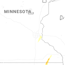
Minnesota
| Local Time | Report Details |
|---|---|
| 5:35 PM CDT | Large tree branches down due to strong wind in wilkin county MN, 46.9 miles SSE of Fargo, ND |
| 5:40 PM CDT | Ndawn mesonet: rothsay 2w 10m gus in wilkin county MN, 35.3 miles SE of Fargo, ND |
| 5:40 PM CDT | Ndawn mesonet: foxhome 4e 10m gus in otter tail county MN, 48.8 miles SSE of Fargo, ND |
| 6:35 PM CDT | Extensive tree damage with numerous trees snapped due to prolonged strong wind in otter tail county MN, 41.1 miles SE of Fargo, ND |
| 7:29 PM CDT | Ping Pong Ball sized hail reported near Wykoff, MN, 50.9 miles W of La Crosse, WI, majority of stones were penny to quarter size. |
| 7:42 PM CDT | Quarter sized hail reported near Chatfield, MN, 46.9 miles W of La Crosse, WI |
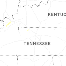
Tennessee
| Local Time | Report Details |
|---|---|
| 6:23 PM CDT | Tree down on south berrys chapel road near lynnwood way... blocking road. time estimated from rada in williamson county TN, 14.4 miles SSW of Nashville, TN |
| 6:58 PM CDT | 10...000 customers without power in the berry hill are in davidson county TN, 3.3 miles S of Nashville, TN |
Arkansas
| Local Time | Report Details |
|---|---|
| 7:50 PM CDT | Quarter sized hail reported near Fort Smith, AR, 10 miles S of Fort Smith, AR |
| 7:57 PM CDT | Quarter sized hail reported near Barling, AR, 7.3 miles ESE of Fort Smith, AR |
| 9:27 PM CDT | 60 mph winds reported via ham radio operator to county em in the vicinity of paris... a in logan county AR, 44.6 miles E of Fort Smith, AR |
| 10:15 PM CDT | Large tree limb down on west ash street in pottsville... a in pope county AR, 56.4 miles NW of Little Rock, AR |
| 11:00 PM CDT | A large tree down near greers ferry just past the narrows bridg in cleburne county AR, 56.1 miles N of Little Rock, AR |
| 4:12 AM CDT | Tree limbs blown dow in pulaski county AR, 9.9 miles NNE of Little Rock, AR |
Illinois
| Local Time | Report Details |
|---|---|
| 1:44 AM CDT | Tree fell onto a car in herri in williamson county IL, 44.4 miles NE of Cape Girardeau, MO |
Connect with Interactive Hail Maps