

Hail Map for Wednesday, May 22, 2019

Number of Impacted Households on 5/22/2019
0
Impacted by 1" or Larger Hail
0
Impacted by 1.75" or Larger Hail
0
Impacted by 2.5" or Larger Hail
Square Miles of Populated Area Impacted on 5/22/2019
0
Impacted by 1" or Larger Hail
0
Impacted by 1.75" or Larger Hail
0
Impacted by 2.5" or Larger Hail


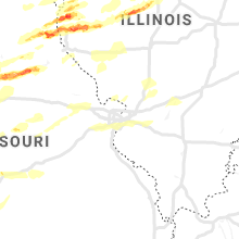

Cities Most Affected by Hail Storms of 5/22/2019
| Hail Size | Demographics of Zip Codes Affected | ||||||
|---|---|---|---|---|---|---|---|
| City | Count | Average | Largest | Pop Density | House Value | Income | Age |
| Higbee, MO | 2 | 2.38 | 3.00 | 19 | $28k | $32.0k | 42.9 |
| Okmulgee, OK | 2 | 2.25 | 2.75 | 73 | $44k | $26.0k | 38.4 |
| Skiatook, OK | 2 | 2.13 | 2.50 | 72 | $74k | $40.8k | 37.6 |
| Moberly, MO | 1 | 1.75 | 1.75 | 139 | $51k | $30.3k | 37.0 |
| Burkburnett, TX | 1 | 1.75 | 1.75 | 148 | $64k | $38.5k | 38.2 |
| Columbus, KS | 1 | 1.75 | 1.75 | 24 | $46k | $29.6k | 41.2 |
| Forest City, IL | 1 | 1.75 | 1.75 | 11 | $66k | $36.3k | 41.5 |
Hail and Wind Damage Spotted on 5/22/2019
Filter by Report Type:Hail ReportsWind Reports
Oklahoma
| Local Time | Report Details |
|---|---|
| 5:48 PM CDT | Baseball sized hail reported near Okmulgee, OK, 36.6 miles S of Tulsa, OK |
| 5:53 PM CDT | Golf Ball sized hail reported near Okmulgee, OK, 36.6 miles S of Tulsa, OK |
| 5:55 PM CDT | Golf Ball sized hail reported near Skiatook, OK, 15.2 miles N of Tulsa, OK |
| 6:10 PM CDT | Quarter sized hail reported near Mounds, OK, 19 miles SSW of Tulsa, OK |
| 6:13 PM CDT | Tennis Ball sized hail reported near Skiatook, OK, 21 miles N of Tulsa, OK |
| 6:26 PM CDT | Half Dollar sized hail reported near Okmulgee, OK, 29.5 miles SSE of Tulsa, OK |
| 6:59 PM CDT | Quarter sized hail reported near Covington, OK, 57.9 miles N of Oklahoma City, OK |
| 7:15 PM CDT | Ping Pong Ball sized hail reported near Hollister, OK, 37.1 miles NW of Wichita Falls, TX |
| 7:19 PM CDT | Quarter sized hail reported near Catoosa, OK, 13.9 miles ENE of Tulsa, OK, quarter hail from a picture |
| 7:23 PM CDT | Half Dollar sized hail reported near Catoosa, OK, 13.9 miles ENE of Tulsa, OK |
| 7:28 PM CDT | Quarter sized hail reported near Claremore, OK, 20.5 miles ENE of Tulsa, OK, hail reported vicinity of highways 66 and 266. |
| 7:38 PM CDT | Quarter sized hail reported near Claremore, OK, 25.4 miles ENE of Tulsa, OK |
| 7:38 PM CDT | Ping Pong Ball sized hail reported near Claremore, OK, 24.6 miles ENE of Tulsa, OK |
| 7:38 PM CDT | Storm damage reported in rogers county OK, 24.6 miles ENE of Tulsa, OK |
| 8:05 PM CDT | Quarter sized hail reported near Stillwater, OK, 54.8 miles NNE of Oklahoma City, OK |
| 9:29 PM CDT | Storm damage reported in osage county OK, 29.8 miles NNW of Tulsa, OK |
| 11:10 PM CDT | Trees uprooted or snapped... roof blown off in pawnee county OK, 27.5 miles WNW of Tulsa, OK |
| 12:50 AM CDT | Thunderstorm winds between vinita and bernice estimated at 70 to 80 mp in delaware county OK, 65.4 miles ENE of Tulsa, OK |
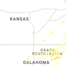
Kansas
| Local Time | Report Details |
|---|---|
| 6:05 PM CDT | Quarter sized hail reported near Garnett, KS, 43.6 miles NNE of Chanute, KS, largest hail the spotter observed but the better core aloft developed just east of this location. |
| 6:51 PM CDT | Golf Ball sized hail reported near Columbus, KS, 45.2 miles SE of Chanute, KS |
Texas
| Local Time | Report Details |
|---|---|
| 6:25 PM CDT | Quarter sized hail reported near Seymour, TX, 38.7 miles WSW of Wichita Falls, TX |
| 7:42 PM CDT | Golf Ball sized hail reported near Burkburnett, TX, 13.1 miles NNW of Wichita Falls, TX |
| 7:42 PM CDT | Ping Pong Ball sized hail reported near Burkburnett, TX, 11.9 miles NNW of Wichita Falls, TX |
| 7:51 PM CDT | Quarter sized hail reported near Burkburnett, TX, 13 miles NNW of Wichita Falls, TX |
Missouri
| Local Time | Report Details |
|---|---|
| 7:30 PM CDT | Ping Pong Ball sized hail reported near El Dorado Springs, MO, 61.2 miles NW of Springfield, MO |
| 7:45 PM CDT | Pea sized hai in johnson county MO, 44.5 miles SE of Kansas City, MO |
| 8:00 PM CDT | Quarter sized hail reported near Monticello, MO, 20.8 miles S of Kahoka, MO |
| 8:04 PM CDT | Quarter sized hail reported near Bethel, MO, 36.1 miles SSW of Kahoka, MO |
| 8:30 PM CDT | Tea Cup sized hail reported near Higbee, MO, 24.9 miles NNW of Columbia, MO, largest hail was estimated to be 3 inches. but there were piles of smaller hail a foot deep. windshields of cars were punched through. time estimated from radar. |
| 8:30 PM CDT | Golf Ball sized hail reported near Moberly, MO, 32.3 miles N of Columbia, MO |
| 8:30 PM CDT | Golf Ball sized hail reported near Higbee, MO, 26.4 miles NNW of Columbia, MO, golf ball sized hail caused damage to numerous cars. |
| 8:30 PM CDT | Quarter sized hail reported near Lincoln, MO, 66.4 miles SW of Columbia, MO |
| 8:37 PM CDT | Quarter sized hail reported near Moberly, MO, 27.6 miles NNW of Columbia, MO, pea to quarter sized hail currently falling. |
| 8:40 PM CDT | Quarter sized hail reported near Clark, MO, 26.9 miles N of Columbia, MO |
| 8:40 PM CDT | Storm damage reported in randolph county MO, 26.9 miles N of Columbia, MO |
| 8:50 PM CDT | Quarter sized hail reported near Madison, MO, 30.5 miles N of Columbia, MO |
| 9:05 PM CDT | Ping Pong Ball sized hail reported near Golden City, MO, 47.8 miles WNW of Springfield, MO |
| 9:33 PM CDT | Trees down on boothe lan in boone county MO, 6.8 miles WNW of Columbia, MO |
| 9:37 PM CDT | Quarter sized hail reported near Stockton, MO, 43.7 miles NW of Springfield, MO |
| 9:55 PM CDT | Kmyj awo in audrain county MO, 31.2 miles ENE of Columbia, MO |
| 10:01 PM CDT | Storm damage reported in audrain county MO, 29.9 miles ENE of Columbia, MO |
| 11:02 PM CDT | Getting reports of damage in eldon. details uncertain at this time. possible td in miller county MO, 43.6 miles SSW of Columbia, MO |
Iowa
| Local Time | Report Details |
|---|---|
| 7:52 PM CDT | Quarter sized hail reported near Keokuk, IA, 16.9 miles E of Kahoka, MO |
Illinois
| Local Time | Report Details |
|---|---|
| 8:17 PM CDT | Large barn down in elderville il... possible tornado damage. time estimated based on radar. image was shared on social medi in hancock county IL, 23 miles ESE of Kahoka, MO |
| 8:40 PM CDT | Power lines down. time estimated based on rada in hancock county IL, 28.6 miles ESE of Kahoka, MO |
| 8:45 PM CDT | Half Dollar sized hail reported near Quincy, IL, 31.6 miles SE of Kahoka, MO |
| 8:54 PM CDT | Measured at highway 24 and interstate 17 in adams county IL, 35.7 miles SE of Kahoka, MO |
| 8:55 PM CDT | Storm damage reported in adams county IL, 34.4 miles SE of Kahoka, MO |
| 8:55 PM CDT | Quarter sized hail reported near Coatsburg, IL, 40 miles SE of Kahoka, MO, hail lasted 2-3 minutes. |
| 9:04 PM CDT | 3-4 inch limbs dow in adams county IL, 43.2 miles SE of Kahoka, MO |
| 9:07 PM CDT | Wind measured from sensor on top of single story fire station. 6 foot by 12 foot section of fence blown dow in adams county IL, 40 miles SE of Kahoka, MO |
| 9:11 PM CDT | Quarter sized hail reported near Golden, IL, 42.6 miles ESE of Kahoka, MO, time estimated from radar. |
| 9:55 PM CDT | Drive-up atm building blown ove in fulton county IL, 25.5 miles WSW of Peoria, IL |
| 10:20 PM CDT | Large trees down along illinois route 100 in fulton county IL, 46.1 miles SW of Peoria, IL |
| 10:45 PM CDT | Golf Ball sized hail reported near Forest City, IL, 31.7 miles SSW of Peoria, IL |
| 11:37 PM CDT | Storm damage reported in scott county IL, 67.8 miles NNW of Saint Louis, MO |
| 11:45 PM CDT | Trees down along with power outages in the white hall are in greene county IL, 57.1 miles N of Saint Louis, MO |
| 11:46 PM CDT | Storm damage reported in morgan county IL, 74.6 miles SSW of Peoria, IL |
| 11:55 PM CDT | Storm damage reported in morgan county IL, 66.5 miles SSW of Peoria, IL |
| 11:57 PM CDT | Structural damage to numerous outbuildings. large 40 by 80 machine sheds completely destroyed. numerous trees uprooted and snapped... numerous power poles snapped. one in cass county IL, 59.7 miles SSW of Peoria, IL |
| 12:00 AM CDT | Loss of power in town in morgan county IL, 63.5 miles SSW of Peoria, IL |
| 12:15 AM CDT | Three trees blown dow in menard county IL, 44.3 miles S of Peoria, IL |
| 12:15 AM CDT | Several trees down... including one on a hous in sangamon county IL, 55.4 miles S of Peoria, IL |
| 12:16 AM CDT | Storm damage reported in sangamon county IL, 63 miles S of Peoria, IL |
| 12:17 AM CDT | Powerlines down at prince and parkway d in sangamon county IL, 55.4 miles S of Peoria, IL |
| 12:19 AM CDT | Five power poles snapped in sangamon county IL, 51.2 miles S of Peoria, IL |
| 12:19 AM CDT | Power lines down on illinois route 123 in sangamon county IL, 51.2 miles S of Peoria, IL |
| 12:20 AM CDT | Powerlines bent... 1-2 inch tree limbs at chatham road and veterans pkw in sangamon county IL, 63 miles S of Peoria, IL |
| 12:21 AM CDT | Power pole and trees down in sangamon county IL, 68.3 miles W of Mattoon, IL |
| 12:30 AM CDT | Trees and powerlines dow in sangamon county IL, 68.3 miles W of Mattoon, IL |
| 12:34 AM CDT | 12 inch tree limb down in logan county IL, 39.1 miles SSE of Peoria, IL |
| 12:36 AM CDT | Two vehicles blown off of interstate 5 in logan county IL, 38.3 miles SSE of Peoria, IL |
| 12:40 AM CDT | Vehicle on interstate 55 blown into ditc in logan county IL, 35.7 miles SSE of Peoria, IL |
| 12:56 AM CDT | Numerous tree limbs blown dow in mclean county IL, 34.8 miles ESE of Peoria, IL |
| 1:02 AM CDT | Storm damage reported in christian county IL, 58.4 miles W of Mattoon, IL |
| 1:05 AM CDT | Trees down on a house and power lines dow in macon county IL, 42.3 miles NNW of Mattoon, IL |
| 1:05 AM CDT | Trees down on a house on harper avenu in macon county IL, 39 miles NW of Mattoon, IL |
| 1:09 AM CDT | Storm damage reported in mclean county IL, 38.1 miles ESE of Peoria, IL |
| 1:11 AM CDT | 6ft diameter 115ft tall tree partially uprooted and snapped. 4ft 80ft tall tree snappe in piatt county IL, 40.8 miles NNW of Mattoon, IL |
| 1:27 AM CDT | Large tree branch down on hous in champaign county IL, 57.9 miles N of Mattoon, IL |
| 1:30 AM CDT | Large tree down on lott blvd in gibson city. power out across the town. lots of other limbs down. time estimated from rada in ford county IL, 65.9 miles ESE of Peoria, IL |
| 1:42 AM CDT | Power pole snapped at prospect and washington. time estimated by rada in champaign county IL, 43.8 miles N of Mattoon, IL |
| 1:44 AM CDT | Storm damage reported in champaign county IL, 38.9 miles N of Mattoon, IL |
| 1:47 AM CDT | Reported at 2667 n 1700e rd... piper city... il 60959. stuckey farm in ford county IL, 75.8 miles E of Peoria, IL |
| 2:03 AM CDT | Large tree limbs and power lines down on illinois route 49 and 1900 north roa in vermilion county IL, 51.4 miles NNE of Mattoon, IL |
| 2:03 AM CDT | Reports from watseka auxillary police of numerous trees... powerlines... and telephone poles down near and nw of us route 24. roads are being blocked off. time estimate in iroquois county IL, 76.4 miles S of Chicago, IL |
| 2:04 AM CDT | Measured in the northeast part of the cit in iroquois county IL, 76.4 miles S of Chicago, IL |
| 2:06 AM CDT | Numerous power poles down on illinois route 49 near hope townshi in vermilion county IL, 56.5 miles NNE of Mattoon, IL |
| 2:06 AM CDT | Numerous power poles blown down at us highway 150 and 450 east roa in vermilion county IL, 51.3 miles NNE of Mattoon, IL |
| 2:15 AM CDT | Numerous trees and power lines blown down around tow in vermilion county IL, 77.8 miles NNE of Mattoon, IL |
| 2:17 AM CDT | Numerous reports of trees... tree limbs and power lines down across the city. at least two houses damaged by downed tree in vermilion county IL, 60.7 miles NE of Mattoon, IL |
Michigan
| Local Time | Report Details |
|---|---|
| 9:51 PM EDT | Quarter sized hail reported near Rapid River, MI, 57.1 miles SE of Marquette, MI, public report of 1 inch diameter hail 2 nw of isabella at 9:51 pm. |
| 9:55 PM EDT | Quarter sized hail reported near Gladstone, MI, 51.6 miles SSE of Marquette, MI, public reported 1 inch diameter hail in downtown gladstone at 9:23 pm. |
| 4:30 AM EDT | Trees and powerlines down in st joseph county. specifically... at cleveland road and fir road... ash road and dunn road... riley road at oak road... and merrifield driv in st. joseph county MI, 52.7 miles NNW of Fort Wayne, IN |
| 5:23 AM EDT | Trees uprooted... blown over and power lines down. relayed via publi in branch county MI, 59.9 miles N of Fort Wayne, IN |
| 5:37 AM EDT | Power lines reported down. time estimated from rada in hillsdale county MI, 55.8 miles NNE of Fort Wayne, IN |
| 5:40 AM EDT | Numerous reports of trees and large limbs down in hillsdale... including north adams road and lynn street. trees blocking state street and pittsford r in hillsdale county MI, 63.2 miles NNE of Fort Wayne, IN |
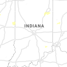
Indiana
| Local Time | Report Details |
|---|---|
| 2:20 AM CDT | Storm damage reported in newton county IN, 77.5 miles S of Chicago, IL |
| 3:30 AM EDT | Grain bin was blown over and blown several yard in benton county IN, 80.8 miles NW of Indianapolis, IN |
| 2:35 AM CDT | Awos station krzl rensselaer airpor in jasper county IN, 68.6 miles SSE of Chicago, IL |
| 2:44 AM CDT | Storm damage reported in jasper county IN, 56 miles SSE of Chicago, IL |
| 2:44 AM CDT | Trees down near 1100 w and rt 4 in jasper county IN, 57.8 miles SSE of Chicago, IL |
| 2:44 AM CDT | Trees down near 900w and rt 4 in jasper county IN, 59.6 miles SSE of Chicago, IL |
| 3:57 AM EDT | Corrects previous tstm wnd gst report from 3 w west lafayett in tippecanoe county IN, 64.1 miles NW of Indianapolis, IN |
| 4:11 AM EDT | Several 4-6 inch tree limbs snapped near west strawberry road in rockville. time estimated from rada in parke county IN, 58 miles W of Indianapolis, IN |
| 4:20 AM EDT | Trees and power lines down around east side of mishawaka along us 331 and bremen hw in st. joseph county IN, 68.4 miles NW of Fort Wayne, IN |
| 4:20 AM EDT | Significant tree damage in area. large wood playpen tossed several yard in marshall county IN, 61.1 miles W of Fort Wayne, IN |
| 4:20 AM EDT | Trees down on power lines. time estimated from rada in fulton county IN, 58.5 miles W of Fort Wayne, IN |
| 4:24 AM EDT | Tree fell onto apartment comple in tippecanoe county IN, 64.1 miles NW of Indianapolis, IN |
| 4:28 AM EDT | Tree down on us 30 east of bourbo in marshall county IN, 53.2 miles WNW of Fort Wayne, IN |
| 4:29 AM EDT | Storm damage reported in kosciusko county IN, 49.6 miles W of Fort Wayne, IN |
| 4:30 AM EDT | Relayed report from trained spotter. very large tree down in tow in elkhart county IN, 57.7 miles NW of Fort Wayne, IN |
| 4:37 AM EDT | Storm damage reported in kosciusko county IN, 42.1 miles WNW of Fort Wayne, IN |
| 4:40 AM EDT | Tree down and blocking northbound highway 13... time estimated by rada in kosciusko county IN, 34.6 miles WNW of Fort Wayne, IN |
| 4:40 AM EDT | Tree down across highway 13 in north webster... time estimated by rada in kosciusko county IN, 35.9 miles WNW of Fort Wayne, IN |
| 4:40 AM EDT | County road 900 east from state road 28 to county road 200 south is closed due to utility poles downe in clinton county IN, 36.1 miles NNW of Indianapolis, IN |
| 4:45 AM EDT | Report of 4-6 inch diameter tree limbs down. time estimated from rada in elkhart county IN, 46.9 miles NW of Fort Wayne, IN |
| 4:45 AM EDT | Branches down and a chimney blown off roo in kosciusko county IN, 39.1 miles WNW of Fort Wayne, IN |
| 4:46 AM EDT | Automated weather station measuremen in kosciusko county IN, 37 miles WNW of Fort Wayne, IN |
| 4:46 AM EDT | Powerlines down across hom in carroll county IN, 61.7 miles NNW of Indianapolis, IN |
| 4:54 AM EDT | 24 inch diameter live tree dow in howard county IN, 48.5 miles N of Indianapolis, IN |
| 5:00 AM EDT | Significant tree and power line damage in and around howe. power ou in lagrange county IN, 47.7 miles NNW of Fort Wayne, IN |
| 5:02 AM EDT | Trees down on roads... time estimated by rada in huntington county IN, 26 miles WSW of Fort Wayne, IN |
| 5:03 AM EDT | Minor structural damage to a church... and to the mt etna fire department next door... time estimated by rada in huntington county IN, 33.4 miles SW of Fort Wayne, IN |
| 5:03 AM EDT | Relayed public report of lots of trees down in wolcottville and power out. time estimated from rada in noble county IN, 34.4 miles NNW of Fort Wayne, IN |
| 5:03 AM EDT | Large tree limb across leighty road... time estimated by rada in noble county IN, 30.5 miles NNW of Fort Wayne, IN |
| 5:09 AM EDT | Trees down... time estimated by rada in huntington county IN, 16.4 miles WSW of Fort Wayne, IN |
| 5:09 AM EDT | Mesonet station dw8874 carme in hamilton county IN, 11.7 miles NNW of Indianapolis, IN |
| 5:10 AM EDT | Report of tree down and estimated 55-60 mph winds in city of huntingto in huntington county IN, 25.3 miles SW of Fort Wayne, IN |
| 5:10 AM EDT | Time estimated by rada in allen county IN, 11.5 miles W of Fort Wayne, IN |
| 5:12 AM EDT | Report of a semi blown over at intersection of sr9 and sr12 in huntington county IN, 33.8 miles SW of Fort Wayne, IN |
| 5:14 AM EDT | Power lines and trees down and trees uprooted and roads closed. orland to pleasant lake are in steuben county IN, 45.3 miles N of Fort Wayne, IN |
| 5:15 AM EDT | Two six inch diameter limbs down... measured 68 mph gust home weather station. numerous reports of power outage in allen county IN, 8.6 miles WSW of Fort Wayne, IN |
| 5:15 AM EDT | Emergency manager reports limbs... trees and power lines down county wide. time estimated from rada in steuben county IN, 37.9 miles N of Fort Wayne, IN |
| 5:25 AM EDT | Two trees down... one into a house and cars... the other blocking intersection. no word on injurie in allen county IN, 1.6 miles W of Fort Wayne, IN |
| 5:26 AM EDT | Corrects previous non-tstm wnd gst report from indianapolis int'l airpor in marion county IN, 8.1 miles WSW of Indianapolis, IN |
| 5:30 AM EDT | Storm damage reported in wells county IN, 23.4 miles S of Fort Wayne, IN |
| 5:31 AM EDT | Multiple tree limbs reported dow in madison county IN, 40.3 miles NNE of Indianapolis, IN |
| 5:35 AM EDT | As this storm was moving in. i had a measured wind gust of 64 miles per hour. and a burst of torrential rai in madison county IN, 33.1 miles NE of Indianapolis, IN |
| 5:38 AM EDT | 70 mph winds estimated with power outages and trees down around town. time estimated from rada in wells county IN, 23.4 miles S of Fort Wayne, IN |
| 5:48 AM EDT | 1 inch diameter tree limb dow in morgan county IN, 15.6 miles SW of Indianapolis, IN |
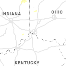
Ohio
| Local Time | Report Details |
|---|---|
| 5:49 AM EDT | Semi blown over on us 30 just west of state rt 4 in van wert county OH, 22.4 miles ESE of Fort Wayne, IN |
| 5:54 AM EDT | Em reports large limbs and trees down across the county. several power poles down and 2 barns damaged on sr111 between county roads 133 and 13 in paulding county OH, 34.3 miles ENE of Fort Wayne, IN |
| 5:55 AM EDT | Semi blown over on sr 637 north of grover hill. driver trapped. no word on injurie in paulding county OH, 32.4 miles E of Fort Wayne, IN |
| 6:02 AM EDT | Power pole down on wabash rd. time estimate in mercer county OH, 45.2 miles SSE of Fort Wayne, IN |
| 6:06 AM EDT | A number of trees reported down at numerous locations in the city of van wer in van wert county OH, 30.6 miles ESE of Fort Wayne, IN |
| 6:20 AM EDT | Corrects time of previous tstm wnd dmg report from napoleon. trees down in and around henry count in henry county OH, 55.2 miles ENE of Fort Wayne, IN |
| 6:21 AM EDT | Power pole down on wabash r in mercer county OH, 45.2 miles SSE of Fort Wayne, IN |
| 6:28 AM EDT | Power lines down in leipsic. report of schools delaying due to power outage in putnam county OH, 57.9 miles E of Fort Wayne, IN |
| 7:00 AM EDT | Trees down in and around henry count in henry county OH, 55.2 miles ENE of Fort Wayne, IN |
| 7:06 AM EDT | Power poles down and leaning along benton-carroll roa in ottawa county OH, 76.8 miles W of Cleveland, OH |
| 7:10 AM EDT | Tree down on house on west wooster stree in wood county OH, 77.7 miles ENE of Fort Wayne, IN |
| 7:14 AM EDT | Tree and power lines dow in ottawa county OH, 64.3 miles W of Cleveland, OH |
| 7:39 AM EDT | Tree down across road in aver in erie county OH, 50.3 miles WSW of Cleveland, OH |
Connect with Interactive Hail Maps