

Hail Map for Saturday, May 30, 2020

Number of Impacted Households on 5/30/2020
0
Impacted by 1" or Larger Hail
0
Impacted by 1.75" or Larger Hail
0
Impacted by 2.5" or Larger Hail
Square Miles of Populated Area Impacted on 5/30/2020
0
Impacted by 1" or Larger Hail
0
Impacted by 1.75" or Larger Hail
0
Impacted by 2.5" or Larger Hail


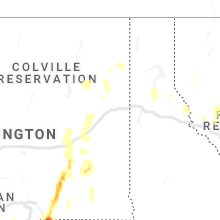


Cities Most Affected by Hail Storms of 5/30/2020
| Hail Size | Demographics of Zip Codes Affected | ||||||
|---|---|---|---|---|---|---|---|
| City | Count | Average | Largest | Pop Density | House Value | Income | Age |
| Bend, OR | 2 | 2.00 | 2.00 | 92 | $155k | $43.3k | 38.5 |
| Monument, OR | 2 | 1.88 | 2.00 | 0 | $45k | $26.6k | 49.0 |
| Helix, OR | 1 | 2.00 | 2.00 | 1 | $88k | $43.8k | 36.2 |
| Chiloquin, OR | 1 | 1.75 | 1.75 | 5 | $90k | $29.4k | 53.2 |
| Spray, OR | 1 | 1.75 | 1.75 | 1 | $74k | $25.6k | 51.1 |
| Crescent, OR | 1 | 1.75 | 1.75 | 0 | $69k | $29.8k | 55.4 |
| Echo, OR | 1 | 1.75 | 1.75 | 1 | $82k | $35.8k | 38.6 |
| Terrebonne, OR | 1 | 1.75 | 1.75 | 61 | $138k | $38.4k | 50.4 |
Hail and Wind Damage Spotted on 5/30/2020
Filter by Report Type:Hail ReportsWind Reports
California
| Local Time | Report Details |
|---|---|
| 5:15 AM PDT | Quarter sized hail reported near Brownsville, CA, 54 miles N of Citrus Heights, CA, quarter sized hail was reported in brownsville... ca. pictures sent to us via social media. |
Oregon
| Local Time | Report Details |
|---|---|
| 11:00 AM PDT | Hen Egg sized hail reported near Bend, OR, 28.8 miles WSW of Bend, OR |
| 11:55 AM PDT | Golf Ball sized hail reported near Chiloquin, OR, 73.7 miles ENE of Medford, OR, hail damaged vehicles. report was from milepost 8 on silver lake highway. |
| 1:05 PM PDT | Hen Egg sized hail reported near Bend, OR, 28.8 miles WSW of Bend, OR |
| 1:14 PM PDT | Golf Ball sized hail reported near Crescent, OR, 71.9 miles SW of Bend, OR, hail damaged vehicles. minor street flooding and mudslides in town also reported. |
| 1:30 PM PDT | Quarter sized hail reported near , , 57.1 miles SW of Bend, OR, hail depth up to 1 inch |
| 1:34 PM PDT | Quarter sized hail reported near La Pine, OR, 52.6 miles SW of Bend, OR, trees down |
| 1:48 PM PDT | Ping Pong Ball sized hail reported near Bend, OR, 31 miles SW of Bend, OR, reported via social media. time estimated from radar. |
| 1:50 PM PDT | Half Dollar sized hail reported near La Pine, OR, 54.6 miles SW of Bend, OR, half dollar sized hail in la pine. |
| 2:00 PM PDT | Quarter sized hail reported near Bend, OR, 42.1 miles SW of Bend, OR, quarter sized hail covering the ground and numerous trees down in sunriver. |
| 2:00 PM PDT | Power lines and trees down. roof blown off. estimated winds at least 70 mp in jefferson county OR, 39.1 miles NW of Bend, OR |
| 2:26 PM PDT | 60-70 mph gusts in jefferson county OR, 24.7 miles WNW of Bend, OR |
| 2:26 PM PDT | Golf Ball sized hail reported near Terrebonne, OR, 24.5 miles WNW of Bend, OR |
| 2:27 PM PDT | Quarter sized hail reported near Prineville, OR, 5.4 miles SE of Bend, OR, time estimated by radar |
| 2:29 PM PDT | Via davis weather station vantage in jefferson county OR, 22.7 miles NW of Bend, OR |
| 2:34 PM PDT | Half Dollar sized hail reported near Redmond, OR, 22.7 miles W of Bend, OR, 1 foot diameter tree also knocked down and said to be healthy. |
| 2:35 PM PDT | Several large trees downed. damage to farm equipment. along hwy 97 5 to 10 miles south of madra in jefferson county OR, 21.1 miles NW of Bend, OR |
| 2:36 PM PDT | Golf Ball sized hail reported near Spray, OR, 63.5 miles NE of Bend, OR, via twitter/social media recieved at 422 pm pdt. |
| 2:40 PM PDT | Media reports damage to homes. large trees down and power outages. rocks on road. estimated wind gusts of 80 to 100 mp in jefferson county OR, 23.5 miles NW of Bend, OR |
| 2:40 PM PDT | 30 foot tree blown down in crook county OR, 0.5 miles NNE of Bend, OR |
| 2:45 PM PDT | Multiple reports of downed trees in madras. reports via social media and storm spotter in jefferson county OR, 27.8 miles NNW of Bend, OR |
| 2:45 PM PDT | Alfalfa and hay crop ruined by hail and damaging winds. social media post in jefferson county OR, 26.6 miles NNW of Bend, OR |
| 2:50 PM PDT | Hen Egg sized hail reported near Monument, OR, 75.9 miles NE of Bend, OR |
| 3:05 PM PDT | Golf Ball sized hail reported near Monument, OR, 79.2 miles ENE of Bend, OR |
| 3:30 PM PDT | Trees down. damage to automobile and home. report via social medi in sherman county OR, 73.1 miles N of Bend, OR |
| 3:39 PM PDT | Mesonet station as463 grass valle in sherman county OR, 71.7 miles N of Bend, OR |
| 3:45 PM PDT | Golf Ball sized hail reported near Echo, OR, 49.1 miles SW of Walla Walla, WA, report via social media |
| 3:48 PM PDT | Mesonet station pafo3 patjen in sherman county OR, 70.4 miles N of Bend, OR |
| 3:52 PM PDT | Mesonet station xmry 5 wsw rufu in sherman county OR, 66.5 miles SSW of Yakima, WA |
| 4:00 PM PDT | Tree down and damage to home. report via social medi in gilliam county OR, 72.5 miles NNE of Bend, OR |
| 4:10 PM PDT | Mesonet station xaln arlington por in gilliam county OR, 62.7 miles SSE of Yakima, WA |
| 4:13 PM PDT | Ping Pong Ball sized hail reported near Pendleton, OR, 39.3 miles SW of Walla Walla, WA, reported via social media. |
| 4:25 PM PDT | Mesonet station xaln arlington port - higher gus in gilliam county OR, 62.7 miles SSE of Yakima, WA |
| 4:31 PM PDT | Half Dollar sized hail reported near Pendleton, OR, 31.5 miles WSW of Walla Walla, WA |
| 4:38 PM PDT | Storm damage reported in morrow county OR, 56.2 miles WSW of Walla Walla, WA |
| 4:40 PM PDT | Storm damage reported in umatilla county OR, 49.3 miles WSW of Walla Walla, WA |
| 4:40 PM PDT | At highway 730 and i-84 trees and powerlines down. roof damage reported. report via social medi in umatilla county OR, 48.8 miles WSW of Walla Walla, WA |
| 4:40 PM PDT | Tree dow in morrow county OR, 65.4 miles SE of Yakima, WA |
| 4:42 PM PDT | Large tree branches down. one quarter mile visibility in blowing dus in umatilla county OR, 48.1 miles WSW of Walla Walla, WA |
| 4:43 PM PDT | Power lines down as wel in umatilla county OR, 49.3 miles WSW of Walla Walla, WA |
| 4:44 PM PDT | Asos station khri hermiston municipal airpor in umatilla county OR, 47.7 miles WSW of Walla Walla, WA |
| 7:10 PM PDT | Hen Egg sized hail reported near Helix, OR, 27.6 miles WSW of Walla Walla, WA, public report via social media of large hail 12 miles north of pendleton. time estimated based of report and radar. |
| 2:00 AM PDT | Quarter sized hail reported near Joseph, OR, 66.9 miles SW of Grangeville, ID, nickel to quarter size hail. hail completely covered the ground. social media post |
Virginia
| Local Time | Report Details |
|---|---|
| 3:50 PM EDT | Tree down reported near the intersection of nansemond parkway and hargrove landing. time estimated from rada in city of suffolk county VA, 23.8 miles W of Virginia Beach, VA |
Utah
| Local Time | Report Details |
|---|---|
| 2:35 PM MDT | Mesonet station kcc02 5.6 ne lake pt (kennecott in salt lake county UT, 16.5 miles W of Salt Lake City, UT |
| 3:10 PM MDT | Mesonet station utpcr 3.8 sw lehi (utah dot in utah county UT, 26.9 miles S of Salt Lake City, UT |
| 3:20 PM MDT | Mesonet station amfkm 3.1 s american fork (uunet in utah county UT, 29.3 miles S of Salt Lake City, UT |
| 3:20 PM MDT | Estimate based on 55mph gust at wendover airport and 65mph gust several miles to the west on the nevada sid in tooele county UT, 90.9 miles E of Elko, NV |
| 3:25 PM MDT | Awos station khif hill afb ogde in davis county UT, 25.2 miles N of Salt Lake City, UT |
| 3:40 PM MDT | Udot site utcir in millard county UT, 27.2 miles NNW of Monroe, UT |
| 3:50 PM MDT | Udot site utcir in millard county UT, 27.2 miles NNW of Monroe, UT |
| 4:00 PM MDT | Dot mesonet site in box elder county UT, 56.1 miles N of Salt Lake City, UT |
| 5:24 PM MDT | Asos station kslc salt lake city intl arp in salt lake county UT, 4.4 miles W of Salt Lake City, UT |
| 5:25 PM MDT | Mesonet station dpg11 15.8 sw dugway (dugway in tooele county UT, 73.4 miles SW of Salt Lake City, UT |
| 5:30 PM MDT | Mesonet station trjo 2.2 e copperton (uunet in salt lake county UT, 16.5 miles SSW of Salt Lake City, UT |
| 5:30 PM MDT | Dept of defense dugway proving ground sensors on camel back mountain reported a 91mph gust at 2m sensor height and a 92mph gust at 10m height. communicated with dugway in tooele county UT, 71.3 miles SW of Salt Lake City, UT |
| 5:30 PM MDT | Dept of defense dugway proving ground sensors on camel back mountain reported a 91mph gust at 2m sensor height and a 92mph gust at 10m height. communicated with dugway in tooele county UT, 71.3 miles SW of Salt Lake City, UT |
| 6:10 PM MDT | Mesonet station lms... locomotive spring in box elder county UT, 82.3 miles NW of Salt Lake City, UT |
Colorado
| Local Time | Report Details |
|---|---|
| 4:31 PM MDT | Asos station kril garfield county rgnl a in garfield county CO, 54.9 miles NE of Grand Junction, CO |
| 5:31 PM MDT | Quarter sized hail reported near Pueblo, CO, 3 miles S of Pueblo, CO |
| 5:32 PM MDT | Quarter sized hail reported near Pueblo, CO, 2.8 miles WNW of Pueblo, CO, reported at pueblo blvd and 11th pueblo. |
| 5:33 PM MDT | Quarter sized hail reported near Pueblo, CO, 0.6 miles NW of Pueblo, CO, reported at 4th and west pueblo. |
| 5:37 PM MDT | Quarter sized hail reported near Pueblo, CO, 0.3 miles SSE of Pueblo, CO |
| 5:38 PM MDT | Quarter sized hail reported near Pueblo, CO, 1.4 miles SW of Pueblo, CO |
| 5:44 PM MDT | Half Dollar sized hail reported near Pueblo, CO, 1.4 miles SW of Pueblo, CO, minor street flooding. |
Washington
| Local Time | Report Details |
|---|---|
| 4:10 PM PDT | Mesonet station xlor loroc island light 2 in klickitat county WA, 59.4 miles SSE of Yakima, WA |
| 4:22 PM PDT | Mesonet station ew3715 goodnoe hill in klickitat county WA, 59 miles S of Yakima, WA |
| 4:42 PM PDT | Mesonet station xirl irrigon ligh in benton county WA, 54.8 miles W of Walla Walla, WA |
| 5:00 PM PDT | Downed trees. report via social medi in benton county WA, 44.5 miles SE of Yakima, WA |
| 5:02 PM PDT | Large tree blocking kennewick ave near newport st. time estimated from rada in benton county WA, 40.8 miles WNW of Walla Walla, WA |
| 5:15 PM PDT | Several photos on facebook showing large trees uprooted with one tree fallen on top of a ca in yakima county WA, 5.9 miles ESE of Yakima, WA |
| 5:45 PM PDT | Several downed trees. report via social medi in yakima county WA, 3.2 miles SSE of Yakima, WA |
| 5:48 PM PDT | Roof damage in walla walla county WA, 16.6 miles N of Walla Walla, WA |
| 6:00 PM PDT | Storm damage reported in grant county WA, 28.8 miles ENE of Yakima, WA |
| 6:00 PM PDT | Reports of trees and power lines down in dayto in columbia county WA, 24.5 miles NE of Walla Walla, WA |
| 6:02 PM PDT | Mesonet station ew5837 kahlotu in franklin county WA, 40.7 miles NNW of Walla Walla, WA |
| 6:15 PM PDT | Damage to large evergreen tre in adams county WA, 47.7 miles N of Walla Walla, WA |
| 6:19 PM PDT | 12 power poles blown over on highway 260 near gill roa in adams county WA, 47 miles N of Walla Walla, WA |
| 6:20 PM PDT | Blowing dust reducing visibility below 1 mile then wind and heavy rain. visibility remained below 1 mile with the rainfal in adams county WA, 55.9 miles N of Walla Walla, WA |
| 6:48 PM PDT | Picture received of uprooted tree. tree was 15 feet tall. time estimated by rada in adams county WA, 52.6 miles WSW of Spokane, WA |
| 6:50 PM PDT | Silcott island agrime in asotin county WA, 60.7 miles ENE of Walla Walla, WA |
| 7:10 PM PDT | Dw6220 cwop statio in whitman county WA, 64.8 miles S of Spokane, WA |
| 7:29 PM PDT | Corrects previous tstm wnd gst report from 5 n airway height in spokane county WA, 9 miles WNW of Spokane, WA |
| 8:01 PM PDT | Measured by geg aso in spokane county WA, 5.7 miles WSW of Spokane, WA |
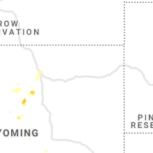
Wyoming
| Local Time | Report Details |
|---|---|
| 5:25 PM MDT | Asos station kgey greybull airpor in big horn county WY, 89.7 miles SSE of Billings, MT |
| 7:30 PM MDT | Quarter sized hail reported near Buffalo, WY, 59.4 miles W of Gillette, WY, time estimated from radar. |
| 7:55 PM MDT | Awos station kafo afton airpor in lincoln county WY, 76.7 miles SE of Idaho Falls, ID |
Idaho
| Local Time | Report Details |
|---|---|
| 5:53 PM MDT | Report of trees down in heyburn. report relayed by broadcast media. time estimated by radar and nearby automated weather station reports. exact location in heyburn unkn in minidoka county ID, 36.7 miles E of Twin Falls, ID |
| 7:01 PM MDT | 71 mph wind gust measured on a personal weather station. roof damage to outbuildings in the area. tree limbs dow in oneida county ID, 93.2 miles SSW of Idaho Falls, ID |
| 7:23 PM MDT | Asos station kllj challi in custer county ID, 48 miles SSW of Salmon, ID |
| 7:35 PM MDT | Report of 25 power poles knocked down just west of american falls. idaho power outage map reports over 1700 customers without power in this area. location and time esti in power county ID, 64.7 miles SW of Idaho Falls, ID |
| 8:05 PM MDT | Mesonet station ato atomic cit in bingham county ID, 38.8 miles W of Idaho Falls, ID |
| 8:40 PM MDT | Mesonet station rov rove in jefferson county ID, 29.1 miles WNW of Idaho Falls, ID |
| 8:40 PM MDT | Mesonet station dea dead man canyo in butte county ID, 51.9 miles W of Idaho Falls, ID |
| 8:50 PM MDT | Mesonet station ket kettle butt in bonneville county ID, 15 miles WNW of Idaho Falls, ID |
| 9:00 PM MDT | Mesonet station ter terreto in jefferson county ID, 30.6 miles NW of Idaho Falls, ID |
| 9:15 PM MDT | Mesonet station rob robert in jefferson county ID, 17.7 miles NNW of Idaho Falls, ID |
| 9:45 PM MDT | Mesonet station itde3 d6 - cama in clark county ID, 47.1 miles NNW of Idaho Falls, ID |
Florida
| Local Time | Report Details |
|---|---|
| 8:35 PM EDT | Report of a large tree down and completely blocking the road on the corner of tohopekaliga road and kissimmee road. radar estimated time of 835 p in osceola county FL, 23.5 miles S of Orlando, FL |
| 9:15 PM EDT | Lake tohopekaliga site on datascope reported a sustained wind speed of 36 mph/31 kt out of the nne with a wind gust of 63 mph/55 k in osceola county FL, 27.5 miles S of Orlando, FL |
Connect with Interactive Hail Maps