

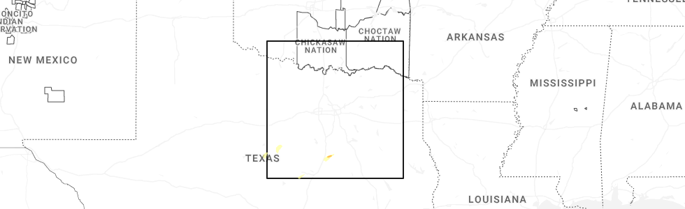
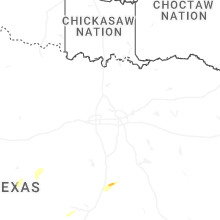
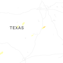
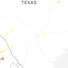
Hail Map for Thursday, November 20, 2025
Number of Impacted Households on 11/20/2025
0
Impacted by 1" or Larger Hail
0
Impacted by 1.75" or Larger Hail
0
Impacted by 2.5" or Larger Hail
Square Miles of Populated Area Impacted on 11/20/2025
0
Impacted by 1" or Larger Hail
0
Impacted by 1.75" or Larger Hail
0
Impacted by 2.5" or Larger Hail
Cities Most Affected by Hail Storms of 11/20/2025
| Hail Size | Demographics of Zip Codes Affected | ||||||
|---|---|---|---|---|---|---|---|
| City | Count | Average | Largest | Pop Density | House Value | Income | Age |
Hail and Wind Damage Spotted on 11/20/2025
Filter by Report Type:Hail ReportsWind Reports
States Impacted
TexasTexas
| Local Time | Report Details |
|---|---|
| 1:29 PM CST | The mesonet station ur226 6.6 w pyote (upr) measured a 60mph wind gust due to strong thunderstorm outflo in ward county TX, 55.8 miles WSW of Odessa, TX |
| 2:01 PM CST | Measured by the west texas mesonet as low-topped convection... with minimal lightning... moved throug in hockley county TX, 29.4 miles W of Lubbock, TX |
| 2:27 PM CST | Measured by the west texas mesonet. a gust to 58 mph was also observed at 2:26 pm. the parent convection had minimal lightning... but the outflow was lofting copious am in lubbock county TX, 11.3 miles W of Lubbock, TX |
| 2:33 PM CST | The west texas mesonet station 18 lamesa 2se measured a 58mph wind gust associated with strong thunderstorm outflo in dawson county TX, 61 miles S of Lubbock, TX |
| 2:44 PM CST | Associated with low-topped convection with minimal lightning. blowing dust also reduced the visibility to 1/4 mil in lubbock county TX, 5.7 miles NNE of Lubbock, TX |
| 2:45 PM CST | The mesonet station fw9685 odessa measured a 60mph wind gust associated with strong thunderstorm outflo in ector county TX, 10 miles NNE of Odessa, TX |
| 2:50 PM CST | The asos station kmaf midland measured a 59mph wind gust due to strong thunderstorm outflo in midland county TX, 12.4 miles NE of Odessa, TX |
| 2:58 PM CST | The west texas mesonet station 84 2wnw tarzan/martin county measured a 61 mph wind gust associated with strong thunderstorm outflo in martin county TX, 38.3 miles NE of Odessa, TX |
| 3:34 PM CST | Storm damage reported in swisher county TX, 46.3 miles S of Amarillo, TX |
| 3:56 PM CST | Storm damage reported in briscoe county TX, 55.9 miles W of Childress, TX |
| 4:35 PM CST | Social media image of snapped power pole in robinson along highway 77. time estimate in mclennan county TX, 42.9 miles ENE of Killeen, TX |
| 4:44 PM CST | Corrects previous tstm wnd dmg report from 3 wsw hallsburg. facebook photo showed large tree limbs down on harrison roa in mclennan county TX, 52.1 miles ENE of Killeen, TX |
| 4:45 PM CST | Corrects previous tstm wnd dmg report from hallsburg. facebook photo showed a sheet metal roof partially blown off a building near hallsburg. other facebook reports als in mclennan county TX, 54.8 miles ENE of Killeen, TX |
| 5:44 PM CST | Facebook photo showed large tree limbs down on harrison roa in mclennan county TX, 52.1 miles ENE of Killeen, TX |
| 5:45 PM CST | Facebook photo showed a sheet metal roof partially blown off a building near hallsburg. other facebook reports also indicate a camper moved 3 feet and windows blown out in mclennan county TX, 54.8 miles ENE of Killeen, TX |
| 8:10 PM CST | Corrects previous tstm wnd dmg report from 2 wsw palestine. facebook report of tree down on cr 2202 one half mile from westwood elementary school. time estimate in anderson county TX, 62.8 miles WNW of Lufkin, TX |
| 9:02 PM CST | Damage reported to a house and a pole barn at tx hwy 135 and cr 4212 ne of jacksonvill in cherokee county TX, 54.4 miles NNW of Lufkin, TX |
| 9:10 PM CST | Facebook report of tree down on cr 2202 one half mile from westwood elementary school. time estimate in anderson county TX, 62.8 miles WNW of Lufkin, TX |
Connect with Interactive Hail Maps