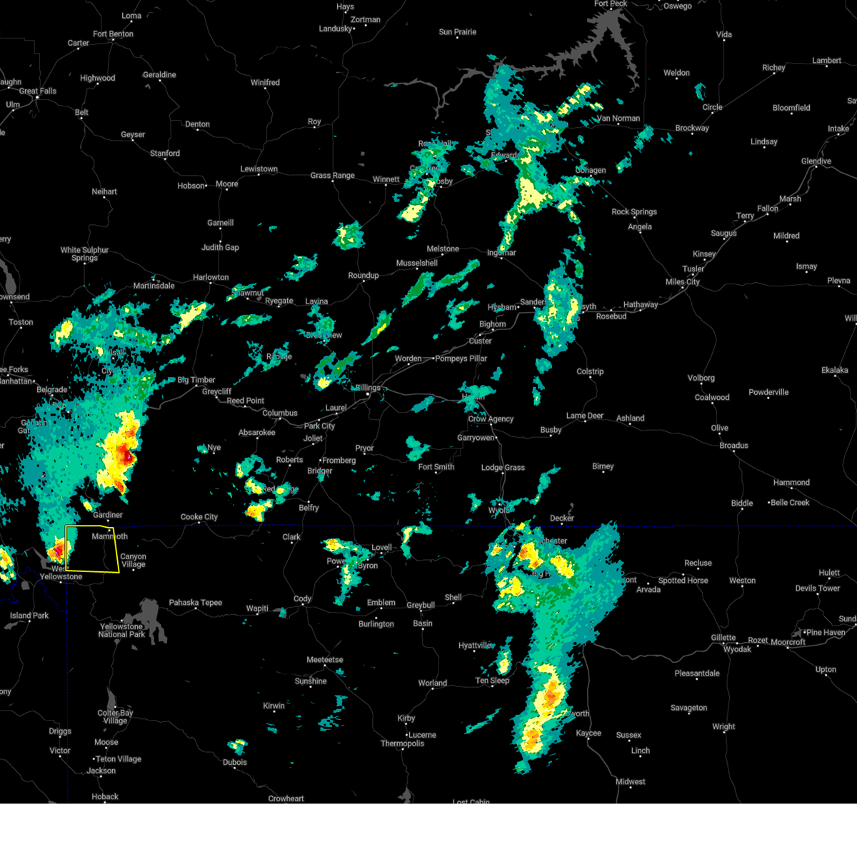
| 6/1/2025 6:15 PM MDT |
Quarter sized hail reported 0.5 miles SE of Mammoth, WY
|
| 6/1/2025 6:01 PM MDT |
 the severe thunderstorm warning has been cancelled and is no longer in effect the severe thunderstorm warning has been cancelled and is no longer in effect
|
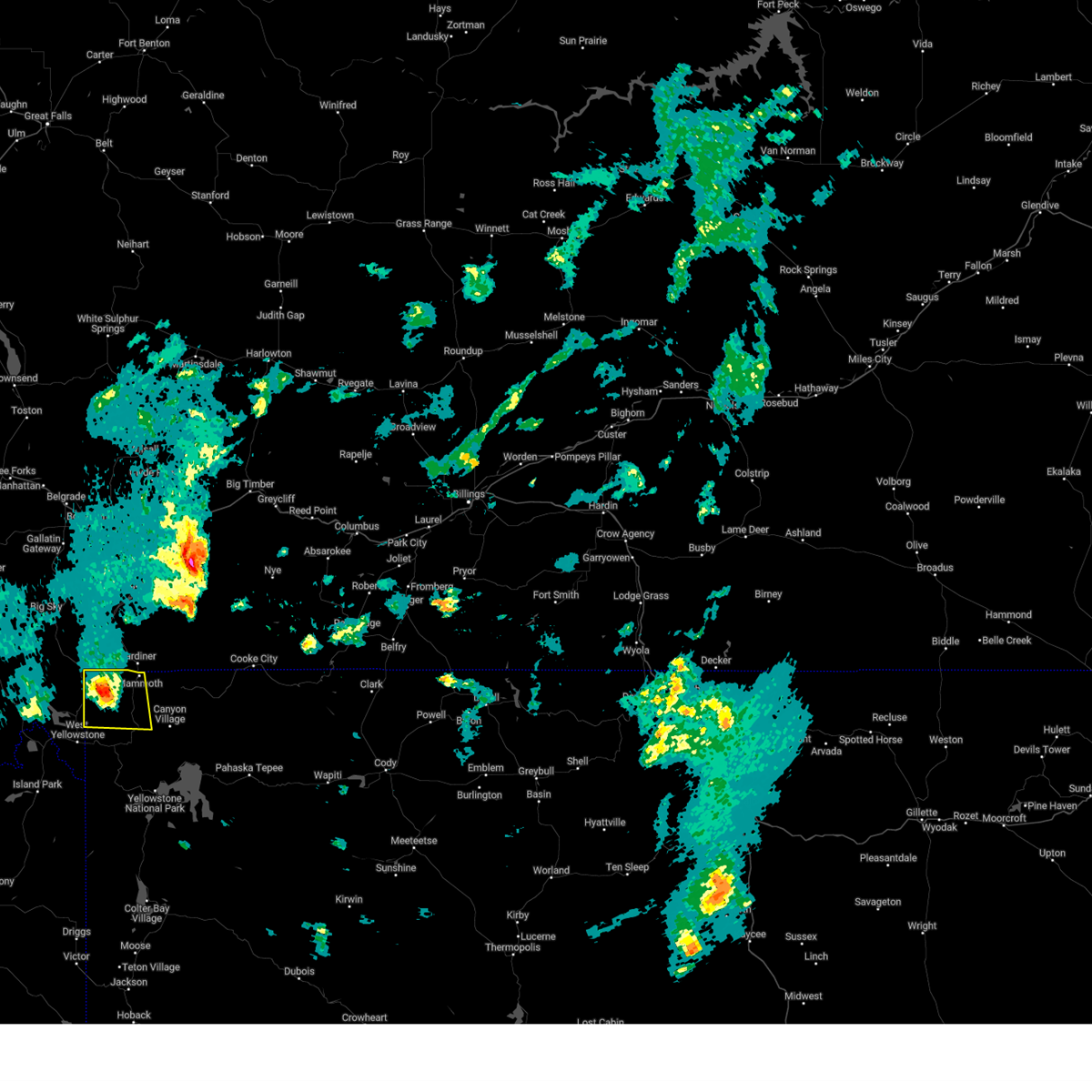
| 6/1/2025 5:39 PM MDT |
 Svrriw the national weather service in riverton has issued a * severe thunderstorm warning for, northwestern park county in central wyoming, * until 615 pm mdt. * at 538 pm mdt, a severe thunderstorm was located 7 miles southwest of divide lake, which is 12 miles north of west yellowstone, moving east at 40 mph (radar indicated). Hazards include half dollar size hail. Damage to vehicles is expected. this severe thunderstorm will be near, divide lake around 545 pm mdt. Gallatin lake around 555 pm mdt. Svrriw the national weather service in riverton has issued a * severe thunderstorm warning for, northwestern park county in central wyoming, * until 615 pm mdt. * at 538 pm mdt, a severe thunderstorm was located 7 miles southwest of divide lake, which is 12 miles north of west yellowstone, moving east at 40 mph (radar indicated). Hazards include half dollar size hail. Damage to vehicles is expected. this severe thunderstorm will be near, divide lake around 545 pm mdt. Gallatin lake around 555 pm mdt.
|
| 8/14/2015 7:58 PM MDT |
 At 757 pm mdt, severe thunderstorms were located along a line extending from osprey falls to near craig pass to 8 miles south of gibson meadows, moving northeast at 40 mph (radar indicated). Hazards include 60 mph wind gusts and penny size hail. Expect damage to roofs. siding and trees. these severe storms will be near, mammoth, grant village, osprey falls, swan lake, willow park and craig pass around 800 pm mdt. blacktail pond around 805 pm mdt. phantom lake around 810 pm mdt. lake, tower junction, mud volcano and floating island lake around 815 pm mdt. other locations impacted by these severe thunderstorms include indian creek campground, lake lodge, lake northwestern corporation power plant, leeks lodge, old faithful northwestern corporation power plant, cave falls campground, flagg ranch village, roosevelt lodge, lizard creek campground and tower fall campground. At 757 pm mdt, severe thunderstorms were located along a line extending from osprey falls to near craig pass to 8 miles south of gibson meadows, moving northeast at 40 mph (radar indicated). Hazards include 60 mph wind gusts and penny size hail. Expect damage to roofs. siding and trees. these severe storms will be near, mammoth, grant village, osprey falls, swan lake, willow park and craig pass around 800 pm mdt. blacktail pond around 805 pm mdt. phantom lake around 810 pm mdt. lake, tower junction, mud volcano and floating island lake around 815 pm mdt. other locations impacted by these severe thunderstorms include indian creek campground, lake lodge, lake northwestern corporation power plant, leeks lodge, old faithful northwestern corporation power plant, cave falls campground, flagg ranch village, roosevelt lodge, lizard creek campground and tower fall campground.
|
| 8/14/2015 7:38 PM MDT |
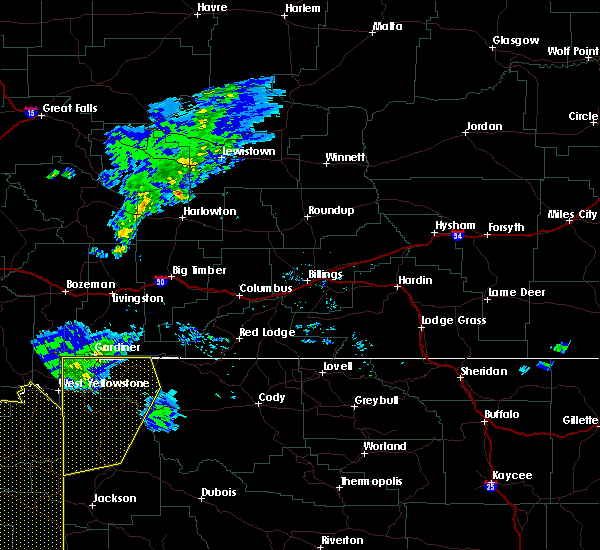 At 736 pm mdt, severe thunderstorms were located along a line extending from near divide lake to near kepler cascades to tetonia, moving northeast at 45 mph (radar indicated). Hazards include 60 mph wind gusts. Expect damage to roofs. siding and trees. severe thunderstorms will be near, old faithful, scaup lake, kepler cascades, gallatin lake, divide lake and mystic falls around 740 pm mdt. craig pass and shoshone lake around 745 pm mdt. grant village, cache lake and willow park around 750 pm mdt. mammoth, swan lake and osprey falls around 755 pm mdt. blacktail pond around 800 pm mdt. phantom lake around 805 pm mdt. lake and mud volcano around 810 pm mdt. south entrance around 815 pm mdt. Other locations impacted by these severe thunderstorms include indian creek campground, lake lodge, lake northwestern corporation power plant, leeks lodge, old faithful northwestern corporation power plant, cave falls campground, flagg ranch village, roosevelt lodge, lizard creek campground and tower fall campground. At 736 pm mdt, severe thunderstorms were located along a line extending from near divide lake to near kepler cascades to tetonia, moving northeast at 45 mph (radar indicated). Hazards include 60 mph wind gusts. Expect damage to roofs. siding and trees. severe thunderstorms will be near, old faithful, scaup lake, kepler cascades, gallatin lake, divide lake and mystic falls around 740 pm mdt. craig pass and shoshone lake around 745 pm mdt. grant village, cache lake and willow park around 750 pm mdt. mammoth, swan lake and osprey falls around 755 pm mdt. blacktail pond around 800 pm mdt. phantom lake around 805 pm mdt. lake and mud volcano around 810 pm mdt. south entrance around 815 pm mdt. Other locations impacted by these severe thunderstorms include indian creek campground, lake lodge, lake northwestern corporation power plant, leeks lodge, old faithful northwestern corporation power plant, cave falls campground, flagg ranch village, roosevelt lodge, lizard creek campground and tower fall campground.
|
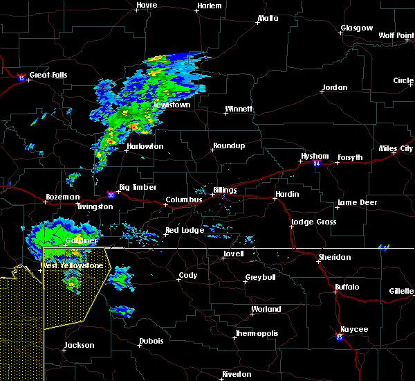
| 6/1/2015 6:36 PM MDT |
At 633 pm mdt, severe thunderstorms were moving northeast at 45 mph through northern teton county and yellowstone national park (law enforcement). Hazards include 70 mph wind gusts and up to dime sized hail. Expect considerable tree damage. damage is likely to mobile homes, roofs and outbuildings. Locations impacted include, mammoth, lake, old faithful, grant village, madison, canyon, tower junction, lower falls, grebe lake, norris junction, mariposa lake, heart lake, ice lake, divide lake, cache lake, firehole canyon, sylvan lake, grizzly lake, mud volcano and phantom lake.
|
| 6/1/2015 6:09 PM MDT |
At 607 pm mdt, severe thunderstorms were located across northern teton county, moving northeast at 45 mph (law enforcement. at 6 pm law enforcement reported trees and power lines downed in the wilson and moose areas). Hazards include 70 mph wind gusts and up to dime sized hail. Expect considerable tree damage. Damage is likely to mobile homes, roofs and outbuildings.
|
| 8/25/2011 6:45 PM MDT |
Quarter sized hail reported 19.6 miles NNW of Mammoth, WY
|


Connect with Interactive Hail Maps