

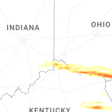
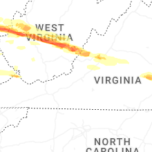
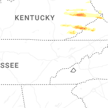
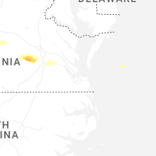
Hail Map for Monday, April 14, 2025

Number of Impacted Households on 4/14/2025
0
Impacted by 1" or Larger Hail
0
Impacted by 1.75" or Larger Hail
0
Impacted by 2.5" or Larger Hail
Square Miles of Populated Area Impacted on 4/14/2025
0
Impacted by 1" or Larger Hail
0
Impacted by 1.75" or Larger Hail
0
Impacted by 2.5" or Larger Hail

Cities Most Affected by Hail Storms of 4/14/2025
| Hail Size | Demographics of Zip Codes Affected | ||||||
|---|---|---|---|---|---|---|---|
| City | Count | Average | Largest | Pop Density | House Value | Income | Age |
| Hurricane, WV | 3 | 1.83 | 2.00 | 242 | $120k | $46.4k | 39.9 |
| Lesage, WV | 2 | 2.13 | 2.25 | 84 | $67k | $27.4k | 44.4 |
| Scott Depot, WV | 2 | 1.75 | 1.75 | 388 | $121k | $47.1k | 41.7 |
| Willow Wood, OH | 1 | 3.00 | 3.00 | 40 | $72k | $25.2k | 40.1 |
| Poca, WV | 1 | 1.75 | 1.75 | 128 | $91k | $41.2k | 41.8 |
| Ironton, OH | 1 | 1.75 | 1.75 | 282 | $63k | $26.9k | 40.6 |
| Kitts Hill, OH | 1 | 1.75 | 1.75 | 65 | $60k | $33.0k | 39.0 |
| Proctorville, OH | 1 | 1.75 | 1.75 | 297 | $87k | $33.0k | 41.8 |
| Charleston, WV | 1 | 1.75 | 1.75 | 2224 | $104k | $15.2k | 45.7 |
| Mount Nebo, WV | 1 | 1.75 | 1.75 | 25 | $69k | $35.1k | 44.6 |
Hail and Wind Damage Spotted on 4/14/2025
Filter by Report Type:Hail ReportsWind Reports
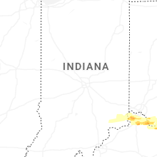
Indiana
| Local Time | Report Details |
|---|---|
| 3:28 PM EDT | Tree down on sr250 and seymour road. time estimated from rada in switzerland county IN, 29.9 miles WSW of Cincinnati, OH |
| 4:26 PM EDT | Corrects previous tstm wnd dmg report from 8 wnw patriot. tree down on sr250 and seymour road. time estimated from rada in switzerland county IN, 29.9 miles WSW of Cincinnati, OH |
Kentucky
| Local Time | Report Details |
|---|---|
| 3:34 PM EDT | Tree down. time estimated from rada in boone county KY, 13.3 miles WSW of Cincinnati, OH |
| 3:52 PM EDT | Quarter sized hail reported near Union, KY, 15.5 miles SW of Cincinnati, OH, video posted on social media. |
| 3:56 PM EDT | Half Dollar sized hail reported near Union, KY, 14 miles SW of Cincinnati, OH, photo verified. |
| 4:05 PM EDT | Half Dollar sized hail reported near Independence, KY, 11.1 miles SSW of Cincinnati, OH, photo verified. |
| 4:24 PM EDT | Quarter sized hail reported near South Shore, KY, 75 miles WNW of Charleston, WV, time is estimated by radar. |
| 4:38 PM EDT | Trees down. time estimated based on rada in greenup county KY, 60.2 miles WNW of Charleston, WV |
| 4:40 PM EDT | Trees down. time estimated based on rada in greenup county KY, 60.6 miles WNW of Charleston, WV |
| 4:40 PM EDT | Trees down. time estimated based on rada in greenup county KY, 61.8 miles WNW of Charleston, WV |
| 5:57 PM EDT | Tree down on scaffold lick road. time estimated from rada in lewis county KY, 80.4 miles WNW of Charleston, WV |
| 6:10 PM EDT | Trees down... with one clipping corner of the house. times estimated based on rada in greenup county KY, 63.8 miles WNW of Charleston, WV |
| 6:12 PM EDT | Two trees across the road. time estimated based on rada in greenup county KY, 73.1 miles WNW of Charleston, WV |
| 7:14 PM EDT | Report of tree down near the intersection of fixer road and hwy 11 north of zoe. report through social medi in lee county KY, 16.2 miles E of Irvine, KY |
| 7:30 PM EDT | Quarter sized hail reported near Campton, KY, 27.9 miles E of Irvine, KY, picture sent to use through social media. |
| 7:32 PM EDT | Half Dollar sized hail reported near Vancleve, KY, 31.3 miles E of Irvine, KY, a public report of half dollar sized hail with picture was received. the event time is radar estimated. |
| 7:49 PM EDT | Quarter sized hail reported near Salyersville, KY, 46.3 miles E of Irvine, KY, multiple social media videos of hail falling near stable branch road and ky-30. lots of smaller hail scattered on the ground... but there are also multiple quarter-size |
| 8:20 PM EDT | A tree was reported to have been blown down onto ky route 30 near the shoulderblade community. the event time is radar estimate in breathitt county KY, 30.9 miles ESE of Irvine, KY |
| 8:30 PM EDT | An outbuilding... a fence... and trees were knocked down and damaged as large hail around a quarter in size was also reported off of smith branch road between ruby dr a in breathitt county KY, 38.5 miles ESE of Irvine, KY |
| 8:32 PM EDT | Quarter sized hail reported near Lost Creek, KY, 40.3 miles ESE of Irvine, KY, quarter sized hail was reported about 3 miles on ky 476 from ky 15. |
| 8:32 PM EDT | Several trees were reported to be down along ky 476 about 3 miles from ky 15 with power ou in breathitt county KY, 40.3 miles ESE of Irvine, KY |
| 8:43 PM EDT | Ping Pong Ball sized hail reported near Jackson, KY, 50.5 miles ESE of Irvine, KY, corrects previous hail report from decoy. social media pictures of large... approximately ping pong ball sized hail in decoy... ky. time estimated via radar. |
| 8:55 PM EDT | Quarter sized hail reported near David, KY, 61.2 miles E of Irvine, KY, social media photograph of various sized hail stones covering the ground in hippo. there are numerous large stones that stick out amongst the rest... and these are at l |
| 8:57 PM EDT | Quarter sized hail reported near Hueysville, KY, 62.9 miles ESE of Irvine, KY, social media picture of measured quarter sized hail along community church road in hueysville... ky. time estimated via radar. |
| 8:58 PM EDT | Quarter sized hail reported near Garrett, KY, 64.6 miles ESE of Irvine, KY, a public report from the garrett community with a picture of hail at least quarter sized. the event time is radar estimated. |
| 8:59 PM EDT | Quarter sized hail reported near Garrett, KY, 64.8 miles ESE of Irvine, KY, a public report from the lackey community with a picture of hail around quarter sized. the event time is radar estimated. |
| 9:10 PM EDT | Social media report of downed trees along island creek road in pike county. time estimated via rada in pike county KY, 62.6 miles NNW of Bristol, TN |
| 12:39 AM EDT | Quarter sized hail reported near Loyall, KY, 65.1 miles WNW of Bristol, TN, social media report of nickel to quarter sized hail in loyall... ky between 12:35 and 12:40am. |
| 12:41 AM EDT | Social media report of a downed tree along route 413 in baxter... just to the north of harlan. time estimated via rada in harlan county KY, 64.3 miles WNW of Bristol, TN |
| 12:42 AM EDT | Quarter sized hail reported near Baxter, KY, 64.3 miles WNW of Bristol, TN, social media report of quarter sized hail along highway 413 in baxter... just to the north of harlan. time estimated via radar. |
| 12:45 AM EDT | Quarter sized hail reported near Eolia, KY, 44.6 miles NW of Bristol, TN, corrects hail report from eolia. social media picture of hail scattered on the ground in eolia. multiple stones of at least quarter-size visible. time estimated via rad |
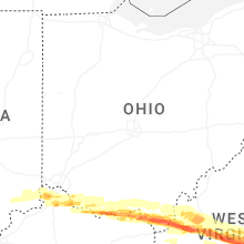
Ohio
| Local Time | Report Details |
|---|---|
| 3:49 PM EDT | Corrects previous tstm wnd dmg report from 2 sse day heights. tree down on dry run road. time estimated from rada in clermont county OH, 16.1 miles E of Cincinnati, OH |
| 3:58 PM EDT | Quarter sized hail reported near Stout, OH, 67.7 miles ESE of Cincinnati, OH, photo verified. |
| 4:30 PM EDT | Ping Pong Ball sized hail reported near Franklin Furnace, OH, 68.4 miles WNW of Charleston, WV, photo of damage to siding on social media. |
| 4:41 PM EDT | Golf Ball sized hail reported near Ironton, OH, 58.5 miles WNW of Charleston, WV, report from mping: golf ball (1.75 in.). time is estimated by radar. |
| 4:47 PM EDT | Golf Ball sized hail reported near Kitts Hill, OH, 53.6 miles WNW of Charleston, WV, report from mping: golf ball (1.75 in.). time is estimated by radar. |
| 4:49 PM EDT | Tea Cup sized hail reported near Willow Wood, OH, 49.3 miles WNW of Charleston, WV |
| 4:49 PM EDT | Quarter sized hail reported near Kitts Hill, OH, 52.4 miles WNW of Charleston, WV, time is estimated by radar. |
| 4:58 PM EDT | Ping Pong Ball sized hail reported near Scottown, OH, 43 miles WNW of Charleston, WV, time estimated by radar. |
| 5:02 PM EDT | Golf Ball sized hail reported near Proctorville, OH, 38 miles WNW of Charleston, WV, some damage to vehicles was observed. |
| 5:02 PM EDT | Tree down on dry run road. time estimated from rada in clermont county OH, 16.1 miles E of Cincinnati, OH |
| 5:49 PM EDT | Large tree reported down on shoestring ridge roa in gallia county OH, 41.8 miles NW of Charleston, WV |
| 5:49 PM EDT | Tree reported down on orchard hill roa in gallia county OH, 42.3 miles NW of Charleston, WV |
Nebraska
| Local Time | Report Details |
|---|---|
| 3:08 PM CDT | Personal weather statio in cedar county NE, 65.4 miles E of Oneill, NE |
| 4:15 PM CDT | Storm damage reported in wayne county NE, 86.3 miles NW of Omaha, NE |
| 4:30 PM CDT | Personal weather statio in knox county NE, 38.3 miles E of Oneill, NE |
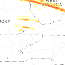
West Virginia
| Local Time | Report Details |
|---|---|
| 5:03 PM EDT | Half Dollar sized hail reported near Lesage, WV, 37.9 miles WNW of Charleston, WV, report from mping: half dollar (1.25 in.). |
| 5:04 PM EDT | Hen Egg sized hail reported near Lesage, WV, 37.5 miles WNW of Charleston, WV, report from mping: hen egg (2.00 in.). |
| 5:04 PM EDT | Hen Egg sized hail reported near Lesage, WV, 37.4 miles WNW of Charleston, WV |
| 5:05 PM EDT | Half Dollar sized hail reported near Lesage, WV, 37.3 miles WNW of Charleston, WV, report from mping: half dollar (1.25 in.). |
| 5:21 PM EDT | Golf Ball sized hail reported near Hurricane, WV, 21.4 miles WNW of Charleston, WV, time is estimated by radar. |
| 5:23 PM EDT | Ping Pong Ball sized hail reported near Hurricane, WV, 18.2 miles WNW of Charleston, WV, report from mping: ping pong ball (1.50 in.). |
| 5:24 PM EDT | Golf Ball sized hail reported near Hurricane, WV, 19.7 miles WNW of Charleston, WV, report from mping: golf ball (1.75 in.). |
| 5:26 PM EDT | Ping Pong Ball sized hail reported near Scott Depot, WV, 17.7 miles WNW of Charleston, WV, time is estimated by radar. |
| 5:26 PM EDT | Golf Ball sized hail reported near Scott Depot, WV, 17.7 miles WNW of Charleston, WV, time is estimated by radar. |
| 5:27 PM EDT | Hen Egg sized hail reported near Hurricane, WV, 19.2 miles WNW of Charleston, WV, hail dented cars and house siding. |
| 5:31 PM EDT | Golf Ball sized hail reported near Scott Depot, WV, 15.8 miles WNW of Charleston, WV |
| 5:32 PM EDT | Quarter sized hail reported near Charleston, WV, 9 miles NW of Charleston, WV, report from mping: quarter (1.00 in.). |
| 5:32 PM EDT | Tree down across roadway. time estimated based on rada in kanawha county WV, 10 miles WNW of Charleston, WV |
| 5:33 PM EDT | Golf Ball sized hail reported near Poca, WV, 12.9 miles NW of Charleston, WV, golf ball size hail. |
| 5:33 PM EDT | Quarter sized hail reported near Nitro, WV, 12.4 miles WNW of Charleston, WV, report from mping: quarter (1.00 in.). time is estimated by radar. |
| 5:37 PM EDT | Ping Pong Ball sized hail reported near Charleston, WV, 9 miles NW of Charleston, WV |
| 5:42 PM EDT | Golf Ball sized hail reported near Charleston, WV, 1 miles E of Charleston, WV, picture of golf ball size hail along morris street in downtown charleston. |
| 5:42 PM EDT | Ping Pong Ball sized hail reported near Charleston, WV, 2.1 miles N of Charleston, WV, time is estimated by radar. |
| 5:43 PM EDT | Quarter sized hail reported near Charleston, WV, 3.8 miles NE of Charleston, WV, report from mping: quarter (1.00 in.). |
| 5:44 PM EDT | Quarter sized hail reported near Charleston, WV, 1.7 miles NE of Charleston, WV |
| 5:49 PM EDT | Quarter sized hail reported near Elkview, WV, 9.6 miles ENE of Charleston, WV, time is estimated by radar. |
| 5:50 PM EDT | Ping Pong Ball sized hail reported near Charleston, WV, 6.3 miles ENE of Charleston, WV |
| 5:57 PM EDT | Large tree down across roadway. time estimated based on rada in wood county WV, 56.4 miles N of Charleston, WV |
| 5:59 PM EDT | Tree down in yard. brought power lines down as wel in wirt county WV, 55.6 miles NNE of Charleston, WV |
| 6:04 PM EDT | Tree down. time estimated based on rada in jackson county WV, 38 miles N of Charleston, WV |
| 6:06 PM EDT | Tree down blocking portion of the road. time estimated based on rada in putnam county WV, 26.2 miles NW of Charleston, WV |
| 6:08 PM EDT | Tree down blocking the roadway. time estimated based on rada in jackson county WV, 42.7 miles N of Charleston, WV |
| 6:12 PM EDT | Tree down. time estimated based on rada in putnam county WV, 25.6 miles NNW of Charleston, WV |
| 6:14 PM EDT | Large tree down with branches down as well. the large tree took down powerline in jackson county WV, 37.3 miles N of Charleston, WV |
| 6:14 PM EDT | Half Dollar sized hail reported near Liberty, WV, 19.6 miles NNW of Charleston, WV, report from mping: half dollar (1.25 in.). time is estimated by radar. |
| 6:18 PM EDT | Tree dow in putnam county WV, 18.4 miles NW of Charleston, WV |
| 6:24 PM EDT | Golf Ball sized hail reported near Mount Nebo, WV, 43.8 miles ESE of Charleston, WV, report from mping: golf ball (1.75 in.). |
| 6:29 PM EDT | Quarter sized hail reported near Mount Nebo, WV, 44.3 miles ESE of Charleston, WV, report from mping: quarter (1.00 in.). time is estimated by radar. |
| 6:30 PM EDT | Tree dow in jackson county WV, 20 miles N of Charleston, WV |
| 7:12 PM EDT | Tree down. time estimated based on rada in putnam county WV, 26.5 miles NW of Charleston, WV |
| 7:15 PM EDT | Quarter sized hail reported near Erbacon, WV, 49 miles SW of Elkins, WV, time estimated by radar. |
| 7:16 PM EDT | Tree down. time based on rada in putnam county WV, 14.1 miles NW of Charleston, WV |
| 7:20 PM EDT | Quarter sized hail reported near Craigsville, WV, 53.7 miles E of Charleston, WV, quarter-sized hail covered the ground. |
| 7:26 PM EDT | Quarter sized hail reported near Camden On Gauley, WV, 55.3 miles SW of Elkins, WV, time is estimated by radar. |
| 7:33 PM EDT | Half Dollar sized hail reported near Barboursville, WV, 34.9 miles W of Charleston, WV, report from mping: half dollar (1.25 in.). |
| 7:54 PM EDT | Half Dollar sized hail reported near Saint Albans, WV, 12.5 miles WNW of Charleston, WV, report from mping: half dollar (1.25 in.). |
| 7:59 PM EDT | Quarter sized hail reported near Summersville, WV, 44 miles E of Charleston, WV, report from mping: quarter (1.00 in.). |
| 8:00 PM EDT | Quarter sized hail reported near Summersville, WV, 44.1 miles E of Charleston, WV, report from mping: quarter (1.00 in.). |
| 8:41 PM EDT | Quarter sized hail reported near Wayne, WV, 43.4 miles W of Charleston, WV, report from mping: quarter (1.00 in.). |
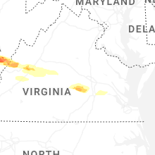
Virginia
| Local Time | Report Details |
|---|---|
| 7:30 PM EDT | Quarter sized hail reported near Hot Springs, VA, 49.9 miles N of Roanoke, VA |
| 8:01 PM EDT | Quarter sized hail reported near Fairfield, VA, 51.9 miles NE of Roanoke, VA |
| 8:24 PM EDT | Tree downed by thunderstorm winds on that bath county side of douthat roa in bath county VA, 43.3 miles N of Roanoke, VA |
| 8:32 PM EDT | Quarter sized hail reported near Lovingston, VA, 68 miles ENE of Roanoke, VA |
| 8:45 PM EDT | Tree downed by thunderstorm winds in the 4400 block of kanawha trai in alleghany county VA, 36 miles NNW of Roanoke, VA |
| 9:01 PM EDT | Tree down blocking roa in amherst county VA, 48.1 miles NE of Roanoke, VA |
| 9:44 PM EDT | Two trees downed on south constitution route near dillwyn. both lanes of traffic close in buckingham county VA, 45.6 miles W of Richmond, VA |
| 10:02 PM EDT | Tree knocked down resulting in power outage. time estimated from rada in cumberland county VA, 34 miles W of Richmond, VA |
| 10:26 PM EDT | Tree down on the 11000 block of genito rd. time estimated from rada in amelia county VA, 12.4 miles WSW of Richmond, VA |
| 10:32 PM EDT | Tree down on hull st rd. time estimated from rada in chesterfield county VA, 11.3 miles SW of Richmond, VA |
| 10:37 PM EDT | Quarter sized hail reported near Chesterfield, VA, 11.2 miles SSW of Richmond, VA, hail covering the ground in the winterpock area. time estimated from radar. |
| 10:42 PM EDT | Quarter sized hail reported near Midlothian, VA, 6.5 miles S of Richmond, VA, report from mping: quarter (1.00 in.). |
| 11:09 PM EDT | Tree knocked down. time estimated from rada in prince george county VA, 28.6 miles SE of Richmond, VA |
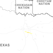
Texas
| Local Time | Report Details |
|---|---|
| 4:14 AM CDT | Quarter sized hail reported near Waxahachie, TX, 22.7 miles S of Dallas, TX, report from mping. |
| 4:33 AM CDT | Quarter sized hail reported near Midlothian, TX, 22.4 miles SSW of Dallas, TX, report from mping. |
Connect with Interactive Hail Maps