

Hail Map for Monday, April 7, 2025

Number of Impacted Households on 4/7/2025
0
Impacted by 1" or Larger Hail
0
Impacted by 1.75" or Larger Hail
0
Impacted by 2.5" or Larger Hail
Square Miles of Populated Area Impacted on 4/7/2025
0
Impacted by 1" or Larger Hail
0
Impacted by 1.75" or Larger Hail
0
Impacted by 2.5" or Larger Hail
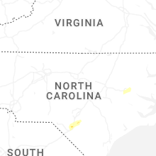
Cities Most Affected by Hail Storms of 4/7/2025
| Hail Size | Demographics of Zip Codes Affected | ||||||
|---|---|---|---|---|---|---|---|
| City | Count | Average | Largest | Pop Density | House Value | Income | Age |
| Greenville, NC | 1 | 1.75 | 1.75 | 841 | $122k | $35.2k | 25.0 |
Hail and Wind Damage Spotted on 4/7/2025
Filter by Report Type:Hail ReportsWind Reports
Georgia
| Local Time | Report Details |
|---|---|
| 8:00 AM EDT | Trees reported down on jericho r in baker county GA, 65.1 miles N of Tallahassee, FL |
| 11:00 AM EDT | Trees reported down on akridge r in grady county GA, 37.5 miles NNE of Tallahassee, FL |
| 11:16 AM EDT | Two trees blown down. there was a radar-indicated tornadic debris signature in the area... so this may have been associated with a tornad in thomas county GA, 43.9 miles NNE of Tallahassee, FL |
| 11:30 AM EDT | Trees reported down... as well as damage to house and bar in colquitt county GA, 49.5 miles NNE of Tallahassee, FL |
| 1:45 PM EDT | Damage to outhouses... trees... portion of aluminum siding on house torn off... rolled over outdoor sheds. aluminum roofing partially pealed off roo in appling county GA, 28.3 miles ENE of Douglas, GA |
| 7:04 PM EDT | Ware county 911/dispatch reports a trees downed on camellia drive in the vicinity of waycross. time of damage based on radar dat in ware county GA, 36.1 miles ESE of Douglas, GA |
| 7:15 PM EDT | Pierce county 911/dispatch reports powerlines downed along u.s. highway 84 in the vicinity of patterson. time of damage based on radar dat in pierce county GA, 42.4 miles ESE of Douglas, GA |
Florida
| Local Time | Report Details |
|---|---|
| 12:00 PM EDT | Ambient weather station reported a wind gust of 64 mp in franklin county FL, 43.9 miles SSW of Tallahassee, FL |
| 12:24 PM EDT | Trees reported down on deer lake rd and buck point r in leon county FL, 12.8 miles NNE of Tallahassee, FL |
| 12:48 PM EDT | The fwsn wakulla st marks lighthouse weatherstem station gusted to 60mph at 12:48pm ed in wakulla county FL, 24 miles SSE of Tallahassee, FL |
| 2:40 PM EDT | Hamilton county 911/dispatch reports a tree downed along northwest 22nd drive near jennings. time of damage based on radar dat in hamilton county FL, 64.4 miles S of Douglas, GA |
| 8:40 PM EDT | Nassau county dispatch/911 reports trees downed in the vicinity of yulee. time of damage based on radar dat in nassau county FL, 20.7 miles N of Jacksonville, FL |
| 8:46 PM EDT | Nassau county 911/dispatch reports powerlines downed in the vicinity of fernandina beach. time of damage based on radar dat in nassau county FL, 24.3 miles NNE of Jacksonville, FL |
North Carolina
| Local Time | Report Details |
|---|---|
| 2:00 PM EDT | 7 large trees and a few powerlines down blocking roads in the laurel hill are in scotland county NC, 79.1 miles ESE of Charlotte, NC |
| 2:10 PM EDT | Asos station kmeb maxto in scotland county NC, 80.6 miles SSW of Raleigh, NC |
| 2:31 PM EDT | Several hundred power outages due to downed trees just southeast of hope mill in cumberland county NC, 59.3 miles SSW of Raleigh, NC |
| 2:33 PM EDT | Several trees down at an office in hope mills. time estimated based on rada in cumberland county NC, 57 miles SSW of Raleigh, NC |
| 2:35 PM EDT | A large limb...12-18 inches in diameter fell off a gum tree knocking out service to an outdoor light. time updated based on rada in robeson county NC, 76.6 miles WNW of Wilmington, NC |
| 2:35 PM EDT | Power lines down on green pasture road near rocky mount. time estimated by rada in edgecombe county NC, 49.7 miles E of Raleigh, NC |
| 2:37 PM EDT | Asos station kfay fayettevill in cumberland county NC, 57.1 miles SSW of Raleigh, NC |
| 2:38 PM EDT | Tree down at mary c r in robeson county NC, 73.2 miles SSW of Raleigh, NC |
| 2:50 PM EDT | Tree down along community r in robeson county NC, 68.5 miles WNW of Wilmington, NC |
| 2:55 PM EDT | A large limb...12-18 inches in diameter fell off a gum tree knocking out service to an outdoor ligh in robeson county NC, 76.6 miles WNW of Wilmington, NC |
| 2:56 PM EDT | Tree down along tolarsville r in robeson county NC, 64.3 miles WNW of Wilmington, NC |
| 3:00 PM EDT | Video of multiple trees falling in neighborhood in roseboro... nc from social media. time estimated from rada in sampson county NC, 58.1 miles S of Raleigh, NC |
| 3:20 PM EDT | Delayed report. large tree down on a home on juniper road. report via faceboo in duplin county NC, 54.2 miles SSE of Raleigh, NC |
| 3:20 PM EDT | Delayed report. the roof was partially torn off the old piggly wiggly in town. report via faceboo in duplin county NC, 53.9 miles SSE of Raleigh, NC |
| 3:20 PM EDT | Awos station kw40 2 ene mount oliv in wayne county NC, 52.1 miles SE of Raleigh, NC |
| 3:23 PM EDT | Multiple reports of trees down on roads... powerlines... and railroad tracks in the faison are in duplin county NC, 53.9 miles SSE of Raleigh, NC |
| 3:23 PM EDT | Tree down intersection highway 117 and tom hill road... blocking one lan in duplin county NC, 56.9 miles SSE of Raleigh, NC |
| 3:25 PM EDT | Multiple reports of trees and powerlines down in the southwestern and southern parts of wayne county... especially in the grantham... dudley and mar mac communities. 25 in wayne county NC, 45.2 miles SE of Raleigh, NC |
| 3:27 PM EDT | Trees down along highway 403 near shelton roa in duplin county NC, 55.1 miles SE of Raleigh, NC |
| 3:30 PM EDT | Trees down along jones turner road blocking one lan in duplin county NC, 54.5 miles SE of Raleigh, NC |
| 3:35 PM EDT | Over 600 power outages reported by duke energy in new hope due to trees down. time estimated based on rada in wayne county NC, 50.8 miles ESE of Raleigh, NC |
| 3:42 PM EDT | Medium sized chain link cage blown over. time estimated from radar. report and picture via faceboo in greene county NC, 53.6 miles ESE of Raleigh, NC |
| 3:55 PM EDT | Trees and wires down along ormondsville roa in greene county NC, 65.2 miles ESE of Raleigh, NC |
| 3:59 PM EDT | Delayed report. tree on power line on contentnea lan in pitt county NC, 70.4 miles ESE of Raleigh, NC |
| 4:04 PM EDT | Delayed report. power lines down on tucker roa in pitt county NC, 78.1 miles E of Raleigh, NC |
| 4:04 PM EDT | Golf Ball sized hail reported near Greenville, NC, 73.7 miles E of Raleigh, NC, spotter estimated golf-ball sized hail in greenville. |
| 4:05 PM EDT | Multiple trees down on carson edwards road near highway 90 in greene county NC, 67.1 miles ESE of Raleigh, NC |
| 4:05 PM EDT | Tree on house in the city of greenvill in pitt county NC, 71.5 miles E of Raleigh, NC |
| 4:05 PM EDT | Trees down on belvoir highwa in pitt county NC, 71.6 miles E of Raleigh, NC |
| 4:05 PM EDT | Trees down on davenport farm roa in pitt county NC, 69.6 miles ESE of Raleigh, NC |
| 4:18 PM EDT | Trees down on boyds road near blackjac in pitt county NC, 84.7 miles ESE of Raleigh, NC |
| 4:32 PM EDT | Duke/progress energy reports power outages caused by fallen trees or limbs damaging their equipment. time estimated based on radar dat in craven county NC, 74.9 miles NE of Wilmington, NC |
| 4:35 PM EDT | Multiple power outages due to thunderstorm wind damage in pinetow in beaufort county NC, 89.9 miles SSW of Virginia Beach, VA |
Virginia
| Local Time | Report Details |
|---|---|
| 2:55 PM EDT | Mesonet station xclt chesapeake light tower gusted to 52 kt or 60 mp in anz656 county VA, 21.8 miles ENE of Virginia Beach, VA |
South Carolina
| Local Time | Report Details |
|---|---|
| 9:46 PM EDT | Mesonet at folly south end recorded a wind gust of 50.1 k in charleston county SC, 38.4 miles S of Charleston, SC |
| 9:51 PM EDT | Mesonet at folly south end recorded a wind gust of 50 kt (57.5 mph in charleston county SC, 38.4 miles S of Charleston, SC |
Connect with Interactive Hail Maps