

Hail Map for Tuesday, August 23, 2016

Number of Impacted Households on 8/23/2016
0
Impacted by 1" or Larger Hail
0
Impacted by 1.75" or Larger Hail
0
Impacted by 2.5" or Larger Hail
Square Miles of Populated Area Impacted on 8/23/2016
0
Impacted by 1" or Larger Hail
0
Impacted by 1.75" or Larger Hail
0
Impacted by 2.5" or Larger Hail


Cities Most Affected by Hail Storms of 8/23/2016
| Hail Size | Demographics of Zip Codes Affected | ||||||
|---|---|---|---|---|---|---|---|
| City | Count | Average | Largest | Pop Density | House Value | Income | Age |
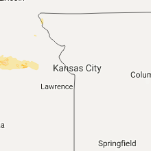
| Cunningham, KS | 1 | 1.75 | 1.75 | 3 | $48k | $33.1k | 50.4 |
Hail and Wind Damage Spotted on 8/23/2016
Filter by Report Type:Hail ReportsWind Reports
Nebraska
| Local Time | Report Details |
|---|---|
| 1:00 PM CDT | Trees and power lines dow in dakota county NE, 69.6 miles WSW of Storm Lake, IA |
| 7:20 PM CDT | Very large tree limbs blown down along highway 3 in douglas county NE, 15.4 miles WNW of Omaha, NE |
| 8:32 PM CDT | Quarter sized hail reported near Blair, NE, 15.5 miles NNW of Omaha, NE, also very strong winds... but no speed given. |
| 9:07 PM CDT | Another spotter also reported a few branches down in fremon in dodge county NE, 31.1 miles WNW of Omaha, NE |
| 9:17 PM CDT | Tree limbs also blown dow in dodge county NE, 31.1 miles WNW of Omaha, NE |
| 9:30 PM CDT | Numerous large trees and power lines blown dow in dodge county NE, 31.1 miles WNW of Omaha, NE |
| 9:49 PM CDT | Koma asos in douglas county NE, 3.4 miles NE of Omaha, NE |
| 10:00 PM CDT | Storm damage reported in douglas county NE, 3.4 miles NE of Omaha, NE |
| 10:10 PM CDT | Storm damage reported in douglas county NE, 3.4 miles NE of Omaha, NE |
Iowa
| Local Time | Report Details |
|---|---|
| 1:50 PM CDT | Power lines down. windows blown out at a bank and a building dow in woodbury county IA, 49.6 miles WSW of Storm Lake, IA |
| 1:53 PM CDT | Damage to trees and crops in woodbury county IA, 56.7 miles WSW of Storm Lake, IA |
| 1:55 PM CDT | Trees down were also reported. reported at 121 deer run trail climbing hill... i in woodbury county IA, 49.6 miles WSW of Storm Lake, IA |
| 2:44 PM CDT | Quarter sized hail reported near Holstein, IA, 20.8 miles WSW of Storm Lake, IA, . |
| 2:45 PM CDT | Quarter sized hail reported near Holstein, IA, 20.4 miles WSW of Storm Lake, IA, . |
| 10:08 PM CDT | 4 inch diameter trees blown dow in pottawattamie county IA, 3.2 miles ENE of Omaha, NE |
Oklahoma
| Local Time | Report Details |
|---|---|
| 4:46 PM CDT | Quarter sized hail reported near Reydon, OK, 62.6 miles SSW of Woodward, OK |
Texas
| Local Time | Report Details |
|---|---|
| 4:55 PM CDT | Quarter sized hail reported near Mobeetie, TX, 79 miles N of Childress, TX |
| 5:15 PM CDT | Large tree limbs blown down...damaging a truck. time estimated in wheeler county TX, 80.1 miles N of Childress, TX |
| 5:18 PM CDT | Large tree blown in half in wheeler county TX, 72.5 miles SW of Woodward, OK |
| 5:19 PM CDT | Storm damage reported in hemphill county TX, 60.7 miles SW of Woodward, OK |
| 5:20 PM CDT | Measured by the texas tech university west texas mesonet in hale county TX, 20.6 miles NNE of Lubbock, TX |
| 6:10 PM CDT | Trees blown dow in hemphill county TX, 65.7 miles WSW of Woodward, OK |
| 6:45 PM CDT | Measured by the texas tech university west texas mesonet in hockley county TX, 29.4 miles W of Lubbock, TX |
| 9:18 PM CDT | Relayed by kolj radio statio in hardeman county TX, 28.4 miles ESE of Childress, TX |
| 9:35 PM CDT | Measured by the texas tech university west texas mesonet in cottle county TX, 38.7 miles SSW of Childress, TX |
| 2:33 AM CDT | Measured at the pecos municipal airport. also very heavy rain fell during stor in reeves county TX, 71.6 miles N of Alpine, TX |
Nevada
| Local Time | Report Details |
|---|---|
| 3:30 PM PDT | Immegration wash mesonet recorded a wind gust of 66 mph. time based on hail reports and radar estimation. in lincoln county NV, 64.6 miles NNW of Saint George, UT |
| 3:30 PM PDT | Immegration wash mesonet recorded a wind gust of 66 mph. time based on hail reports and radar estimation. in lincoln county NV, 64.6 miles NNW of Saint George, UT |
Kansas
| Local Time | Report Details |
|---|---|
| 6:00 PM CDT | Quarter sized hail reported near Concordia, KS, 63.9 miles WNW of Manhattan, KS |
| 6:10 PM CDT | Ping Pong Ball sized hail reported near Pratt, KS, 77.3 miles W of Wichita, KS, time estimated from radar. |
| 6:25 PM CDT | Ping Pong Ball sized hail reported near Pratt, KS, 72.6 miles W of Wichita, KS, this is a correction of a previous report from 4 south of pratt. |
| 6:31 PM CDT | Quarter sized hail reported near Pratt, KS, 73.2 miles W of Wichita, KS, . |
| 7:18 PM CDT | Golf Ball sized hail reported near Cunningham, KS, 60 miles W of Wichita, KS, hail was reported by kake tv. |
| 7:35 PM CDT | Quarter sized hail reported near Lewis, KS, 71.6 miles S of Hays, KS, hail covered ground. |
| 7:37 PM CDT | Quarter sized hail reported near Macksville, KS, 65.8 miles SSE of Hays, KS, time estimated from radar. |
| 7:55 PM CDT | Quarter sized hail reported near Saint John, KS, 62.9 miles SSE of Hays, KS, . |
| 8:20 PM CDT | Clay center airport spotter confident estimate in winds reaching 60mph possibly a little mor in clay county KS, 34.9 miles WNW of Manhattan, KS |
| 8:29 PM CDT | Quarter sized hail reported near Clay Center, KS, 33 miles WNW of Manhattan, KS, winds were estimated up to 50 mph. no damage reported. |
| 8:38 PM CDT | Delayed report in clay county KS, 31.5 miles WNW of Manhattan, KS |
| 9:10 PM CDT | Power poles and power lines down at alembic and sherman roads just southwest of leonardville in riley county KS, 20.3 miles NW of Manhattan, KS |
Connect with Interactive Hail Maps