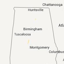
Hail Map for Tuesday, January 10, 2012

Number of Impacted Households on 1/10/2012
0
Impacted by 1" or Larger Hail
0
Impacted by 1.75" or Larger Hail
0
Impacted by 2.5" or Larger Hail
Square Miles of Populated Area Impacted on 1/10/2012
0
Impacted by 1" or Larger Hail
0
Impacted by 1.75" or Larger Hail
0
Impacted by 2.5" or Larger Hail
Regions Impacted by Hail on 1/10/2012
Cities Most Affected by Hail Storms of 1/10/2012
| Hail Size | Demographics of Zip Codes Affected | ||||||
|---|---|---|---|---|---|---|---|
| City | Count | Average | Largest | Pop Density | House Value | Income | Age |
Hail and Wind Damage Spotted on 1/10/2012
Filter by Report Type:Hail ReportsWind Reports
Texas
| Local Time | Report Details |
|---|---|
| 2:05 PM UTC | Quarter sized hail reported near Atlanta, TX, 47.6 miles NNW of Shreveport, LA, nickel to quarter sized hail covering the ground...relayed from media. |
Arkansas
| Local Time | Report Details |
|---|---|
| 2:59 PM UTC | Quarter sized hail reported near Texarkana, AR, 35.7 miles SSW of Nashville, AR |
Alabama
| Local Time | Report Details |
|---|---|
| 9:56 AM UTC | The roof of a barn was torn off and trees were knocked down on county road 1769. time estimated by rada in cullman county AL, 55.1 miles NNE of Birmingham, AL |
| 10:55 AM UTC | The roof of a barn was torn off and trees were knocked down on county road 1769 about one mile north of highway 67. time estimated by rada in cullman county AL, 55.1 miles NNE of Birmingham, AL |


Connect with Interactive Hail Maps