

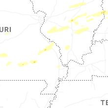
Hail Map for Tuesday, April 29, 2025

Number of Impacted Households on 4/29/2025
0
Impacted by 1" or Larger Hail
0
Impacted by 1.75" or Larger Hail
0
Impacted by 2.5" or Larger Hail
Square Miles of Populated Area Impacted on 4/29/2025
0
Impacted by 1" or Larger Hail
0
Impacted by 1.75" or Larger Hail
0
Impacted by 2.5" or Larger Hail


Cities Most Affected by Hail Storms of 4/29/2025
| Hail Size | Demographics of Zip Codes Affected | ||||||
|---|---|---|---|---|---|---|---|
| City | Count | Average | Largest | Pop Density | House Value | Income | Age |
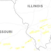
| Webb City, MO | 1 | 1.75 | 1.75 | 441 | $72k | $30.4k | 32.4 |
Hail and Wind Damage Spotted on 4/29/2025
Filter by Report Type:Hail ReportsWind Reports
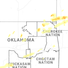
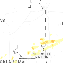
Oklahoma
| Local Time | Report Details |
|---|---|
| 7:01 AM CDT | Quarter sized hail reported near Skiatook, OK, 21.7 miles N of Tulsa, OK, report from mping: quarter (1.00 in.). |
| 7:05 AM CDT | Roof and tree damage reports via social media. time and location estimated by rada in tulsa county OK, 15.1 miles NNE of Tulsa, OK |
| 7:15 AM CDT | Multiple large tree limbs down just east of the rogers and tulsa county lines off 76th street nort in rogers county OK, 14.5 miles NE of Tulsa, OK |
| 7:15 AM CDT | Large tree limbs down near e 76th st n and n 177th e av in rogers county OK, 15 miles NE of Tulsa, OK |
| 7:15 AM CDT | Damage to power pole just north of cromwell. time estimated by rada in seminole county OK, 60.4 miles E of Oklahoma City, OK |
| 7:28 AM CDT | Storm damage reported in rogers county OK, 23.4 miles NE of Tulsa, OK |
| 7:31 AM CDT | Quarter sized hail reported near Claremore, OK, 24.6 miles ENE of Tulsa, OK |
| 7:47 AM CDT | Storm damage reported in mayes county OK, 36.6 miles E of Tulsa, OK |
| 7:55 AM CDT | Mesonet station miam miam in ottawa county OK, 64.2 miles SSE of Chanute, KS |
| 7:58 AM CDT | Power poles and trees down in miam in ottawa county OK, 64.3 miles SSE of Chanute, KS |
| 8:29 AM CDT | Half Dollar sized hail reported near Noble, OK, 23.1 miles SSE of Oklahoma City, OK |
| 8:30 AM CDT | Thunderstorm wind damage reported at delaware county fairgrounds and near highway 59 & e390 road in ja in delaware county OK, 70.8 miles ENE of Tulsa, OK |
Kansas
| Local Time | Report Details |
|---|---|
| 7:21 AM CDT | Quarter sized hail reported near Cherokee, KS, 41.7 miles ESE of Chanute, KS, 1 inch hail just north of cherokee. |
| 7:30 AM CDT | Picture of a tree on a house. time based on radar estimat in crawford county KS, 45.3 miles ESE of Chanute, KS |
| 8:10 AM CDT | Quarter sized hail reported near Galena, KS, 61 miles SE of Chanute, KS, 1 inch hail in galena ks. |
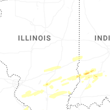
Illinois
| Local Time | Report Details |
|---|---|
| 8:12 AM CDT | Storm damage reported in marion county IL, 66.3 miles SSW of Mattoon, IL |
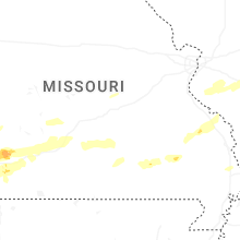
Missouri
| Local Time | Report Details |
|---|---|
| 8:14 AM CDT | Seeing some rotation of cloud in jasper county MO, 66.4 miles SE of Chanute, KS |
| 8:15 AM CDT | Quarter sized hail reported near Joplin, MO, 66.5 miles SE of Chanute, KS |
| 8:20 AM CDT | Ping Pong Ball sized hail reported near Joplin, MO, 65.3 miles W of Springfield, MO, 1.65 inch hail. |
| 8:22 AM CDT | Quarter sized hail reported near Webb City, MO, 64.8 miles SE of Chanute, KS, hail at webb city... been going on about 3 minutes. |
| 8:24 AM CDT | Large tree dow in jasper county MO, 66.1 miles W of Springfield, MO |
| 8:25 AM CDT | Quarter sized hail reported near Webb City, MO, 64 miles W of Springfield, MO, report from mping... quarter 1.00 in. |
| 8:27 AM CDT | Possible tornado damage at the 23 mm i 49 southbound south of neosho in newton county. part of a barn is blocking the interstate with multiple trees down in a defined p in newton county MO, 67.6 miles WSW of Springfield, MO |
| 8:29 AM CDT | Quarter sized hail reported near Webb City, MO, 63.4 miles W of Springfield, MO, report from mping quarter 1.00 in. |
| 8:33 AM CDT | Quarter sized hail reported near Webb City, MO, 64.8 miles SE of Chanute, KS |
| 8:35 AM CDT | I went outside after the storm that passed came through and my i had 2-3 trees snapped in half and they were thick beautiful trees. possible tornad in newton county MO, 57.8 miles WSW of Springfield, MO |
| 8:36 AM CDT | Heavy rain and strong wind est 50-60 mph ne of neosh in newton county MO, 63.3 miles WSW of Springfield, MO |
| 8:36 AM CDT | Golf Ball sized hail reported near Webb City, MO, 64.5 miles W of Springfield, MO, report from mping golf ball 1.75 in. |
| 8:37 AM CDT | Quarter sized hail reported near Webb City, MO, 63.4 miles W of Springfield, MO, report from mping quarter 1.00 in. |
| 8:50 AM CDT | Tree and power lines dow in barry county MO, 41.1 miles WSW of Springfield, MO |
| 8:50 AM CDT | Lots of trees dow in barry county MO, 45.7 miles WSW of Springfield, MO |
| 8:52 AM CDT | Large trees dow in barry county MO, 41.8 miles WSW of Springfield, MO |
| 8:56 AM CDT | Tree on house off highway h monett are in lawrence county MO, 37.9 miles WSW of Springfield, MO |
| 8:56 AM CDT | Report of possible tornado that passed through 8066 lawrence 2205 monett. trees and power lines down per residen in lawrence county MO, 37.6 miles WSW of Springfield, MO |
| 9:00 AM CDT | House damage. time based on radar damag in lawrence county MO, 37.6 miles WSW of Springfield, MO |
| 9:00 AM CDT | Severe home damage. time based on radar estimat in lawrence county MO, 36.6 miles WSW of Springfield, MO |
| 9:00 AM CDT | House is gone. time based on radar estimat in lawrence county MO, 38.1 miles WSW of Springfield, MO |
| 9:05 AM CDT | Vehicle wrapped up in powerlines at business 60 and 60 aurora... missour in lawrence county MO, 28.5 miles WSW of Springfield, MO |
| 9:06 AM CDT | Mesonet station gw5516 mt verno in lawrence county MO, 29.2 miles WSW of Springfield, MO |
| 9:13 AM CDT | Storm damage and debris. time based on radar estimat in christian county MO, 18.9 miles SW of Springfield, MO |
| 9:16 AM CDT | Tree covering road hwy p between clever and republi in christian county MO, 13.2 miles SW of Springfield, MO |
| 9:17 AM CDT | Quarter size hail and debris hwy n and lawrence 210 in lawrence county MO, 22.6 miles W of Springfield, MO |
| 9:18 AM CDT | Significant damage at elliott and hadley and aurora... missour in lawrence county MO, 29.2 miles SW of Springfield, MO |
| 9:18 AM CDT | Tree down. time based on rada in christian county MO, 14.3 miles SSW of Springfield, MO |
| 9:18 AM CDT | Tree down blocking roadway. time based on rada in christian county MO, 14.7 miles WSW of Springfield, MO |
| 9:19 AM CDT | Tree down across county line road covering west bound lane. time based on rada in greene county MO, 12.8 miles SW of Springfield, MO |
| 9:20 AM CDT | Damage to signs at hoods truck stop. time based on radar estimate in greene county MO, 16 miles W of Springfield, MO |
| 9:24 AM CDT | Tree down on o hwy right by alder road. time based on radar estimat in christian county MO, 20 miles S of Springfield, MO |
| 9:24 AM CDT | Corrects previous tstm wnd dmg report from 2 wsw highlandville for time. trees down blocking the highwa in christian county MO, 20 miles S of Springfield, MO |
| 9:24 AM CDT | Tree down on bridge. time based on radar estimat in christian county MO, 9.9 miles SSW of Springfield, MO |
| 9:24 AM CDT | Barn sustained damag in greene county MO, 13.1 miles WNW of Springfield, MO |
| 9:24 AM CDT | Trees across road hw t and e in greene county MO, 11.1 miles W of Springfield, MO |
| 9:27 AM CDT | Corrects previous tstm wnd gst report from nixa. spotter report: 87 mph winds nixa most town has no powe in christian county MO, 11.7 miles S of Springfield, MO |
| 9:27 AM CDT | Spotter report from mt vernon: measured wind over 70 mph in mt vernon... with power lines down in sw corner of tow in christian county MO, 11.7 miles S of Springfield, MO |
| 9:28 AM CDT | Storm damage reported in greene county MO, 5.1 miles WNW of Springfield, MO |
| 9:30 AM CDT | Storm damage reported in greene county MO, 5.8 miles WNW of Springfield, MO |
| 9:30 AM CDT | 3ft diameter trees blown into parking lots. time based on radar estimat in greene county MO, 1 miles W of Springfield, MO |
| 9:30 AM CDT | Structural damage roof hwy ab and e in greene county MO, 7.9 miles WNW of Springfield, MO |
| 9:30 AM CDT | Roof damage on east divison about 300 to 400 yrds west from the airport... and kolor 10s studio. time based on rada in greene county MO, 1.9 miles ENE of Springfield, MO |
| 9:30 AM CDT | Spotter reported tree over power lines at portland and robberson in springfiel in greene county MO, 1.3 miles S of Springfield, MO |
| 9:30 AM CDT | Large tree branches down and power line in greene county MO, 2.3 miles NE of Springfield, MO |
| 9:30 AM CDT | 5ft diameter tree fallen across road (kansas and i-44 in greene county MO, 3 miles NNW of Springfield, MO |
| 9:30 AM CDT | Trees dow in christian county MO, 9.7 miles S of Springfield, MO |
| 9:30 AM CDT | Several tree limbs downed in north springfiel in greene county MO, 2.6 miles NW of Springfield, MO |
| 9:30 AM CDT | Tree on hous in christian county MO, 11 miles S of Springfield, MO |
| 9:31 AM CDT | Fort and harrison tree down across the power lines. lots of tree damage at mt vernon and fort in springfield. time based on radar estimate in greene county MO, 1.2 miles WSW of Springfield, MO |
| 9:31 AM CDT | 2700 block of north glenstone... several utility poles and lines down across the road on the east side outer road near the steak and shake. time based on rada in greene county MO, 3.3 miles NNE of Springfield, MO |
| 9:32 AM CDT | Large tree down (rogers and pacific in greene county MO, 1.9 miles NE of Springfield, MO |
| 9:32 AM CDT | Multiple trees down. uprooted. multiple trees snapped. power line down... power poles snapped. structural and roof damage. time based on rada in greene county MO, 4.4 miles NW of Springfield, MO |
| 9:32 AM CDT | Large tree down covering roa in greene county MO, 3.5 miles N of Springfield, MO |
| 9:32 AM CDT | Storm damage reported in greene county MO, 5.3 miles WNW of Springfield, MO |
| 9:33 AM CDT | Trees down at drury university. time based on radar estimat in greene county MO, 0.8 miles N of Springfield, MO |
| 9:33 AM CDT | Spotter reported semi truck laid over on the west bound lane of i-44 at the bridge at the 75.0 mile marker. time based on radar estimat in greene county MO, 4.3 miles NW of Springfield, MO |
| 9:34 AM CDT | Corrects previous tstm wnd dmg report from 3 wsw springfield. spotter report of a house tree over the house i previously reported on came down on house and collapsed pa in greene county MO, 3.4 miles SW of Springfield, MO |
| 9:34 AM CDT | Storm damage reported in greene county MO, 5.8 miles WNW of Springfield, MO |
| 9:35 AM CDT | Branches up to 4 in down... and a large tree 5ft in diameter... in springfield. tree was split in half... and shingles blown off of roofs in the area. time based on rad in greene county MO, 0.9 miles NNW of Springfield, MO |
| 9:36 AM CDT | Pictures of trees down with some on house. time based on rada in greene county MO, 10.7 miles NE of Springfield, MO |
| 9:36 AM CDT | 2-3 trees have feel over broadway... half the road is blocked. about 4 ft in diameter. time based on rada in greene county MO, 2.9 miles N of Springfield, MO |
| 9:40 AM CDT | Trees down in the road of u and finbrook in christian county MO, 13.9 miles SE of Springfield, MO |
| 9:42 AM CDT | Tree blocking road division and bento in polk county MO, 29.1 miles NNW of Springfield, MO |
| 9:45 AM CDT | Trees on house... 7 outbuildings have trees or roof damage. time based on radar estimat in greene county MO, 12.8 miles NE of Springfield, MO |
| 9:48 AM CDT | Tree limbs of 3 inch diameter being reported snapped in fair grove area. time based on radar estimat in greene county MO, 14.7 miles NNE of Springfield, MO |
| 9:48 AM CDT | Pictures of large trees down and damage to green house. time based on radar estimat in greene county MO, 11.7 miles NE of Springfield, MO |
| 9:55 AM CDT | Tree over powerline in greene county MO, 1.3 miles S of Springfield, MO |
| 12:29 PM CDT | Roof blown off school. time estimated by rada in washington county MO, 46.2 miles ENE of Salem, MO |
Arkansas
| Local Time | Report Details |
|---|---|
| 8:15 AM CDT | Trees uprooted and damaged. trees limbs on vehicles. power poles down. viewer pictures via broadcast media on social medi in benton county AR, 71.4 miles N of Fort Smith, AR |
| 9:00 AM CDT | Big maple tree down. via social medi in benton county AR, 69.3 miles NNE of Fort Smith, AR |
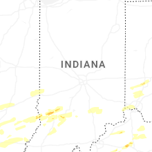
Indiana
| Local Time | Report Details |
|---|---|
| 10:41 AM EDT | Quarter sized hail reported near Lyons, IN, 73.2 miles SW of Indianapolis, IN |
| 11:38 AM EDT | Storm damage reported in morgan county IN, 27.3 miles SSW of Indianapolis, IN |
| 12:14 PM EDT | 56kt gust recorded at kge in shelby county IN, 21.9 miles SE of Indianapolis, IN |
| 12:30 PM EDT | 5 power poles and a tree down on 450 e south of 24 in rush county IN, 46.3 miles ESE of Indianapolis, IN |
| 12:40 PM EDT | Tree down. time approximated form rada in decatur county IN, 44.5 miles ESE of Indianapolis, IN |
| 1:13 PM EDT | Tree downed across roadwa in ripley county IN, 32.6 miles WNW of Cincinnati, OH |
Ohio
| Local Time | Report Details |
|---|---|
| 1:29 PM EDT | Large tree downed across roadwa in montgomery county OH, 38 miles N of Cincinnati, OH |
| 1:40 PM EDT | Asos station kday dayton international airpor in montgomery county OH, 57.5 miles NNE of Cincinnati, OH |
Connect with Interactive Hail Maps