

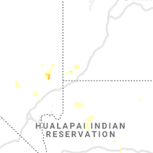
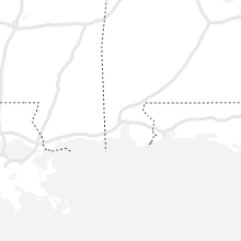
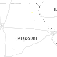
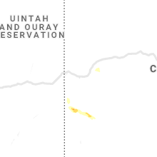
Hail Map for Saturday, July 24, 2021

Number of Impacted Households on 7/24/2021
0
Impacted by 1" or Larger Hail
0
Impacted by 1.75" or Larger Hail
0
Impacted by 2.5" or Larger Hail
Square Miles of Populated Area Impacted on 7/24/2021
0
Impacted by 1" or Larger Hail
0
Impacted by 1.75" or Larger Hail
0
Impacted by 2.5" or Larger Hail


Cities Most Affected by Hail Storms of 7/24/2021
| Hail Size | Demographics of Zip Codes Affected | ||||||
|---|---|---|---|---|---|---|---|
| City | Count | Average | Largest | Pop Density | House Value | Income | Age |
Hail and Wind Damage Spotted on 7/24/2021
Filter by Report Type:Hail ReportsWind Reports
States Impacted
Virginia, Michigan, Utah, Arizona, Illinois, Indiana, Kansas, Colorado, Nevada, Ohio, NebraskaVirginia
| Local Time | Report Details |
|---|---|
| 3:53 PM EDT | A line of trees down along us 360 causing lane closure in amelia county VA, 25.3 miles WSW of Richmond, VA |
| 4:50 PM EDT | Siding damage on house. also... very heavy rai in nottoway county VA, 34.2 miles SW of Richmond, VA |
| 5:06 PM EDT | Trees down on eastbound us 460 near nottoway courthous in nottoway county VA, 34.6 miles SW of Richmond, VA |
| 5:08 PM EDT | Trees down on w courthouse road near nottoway courthous in nottoway county VA, 35.5 miles SW of Richmond, VA |
| 5:25 PM EDT | Tree down on power line that resulted in several power outages. time estimated from rada in nottoway county VA, 34.6 miles SW of Richmond, VA |
Michigan
| Local Time | Report Details |
|---|---|
| 4:03 PM EDT | Multiple reports of down trees and power lines down in midland county MI, 59.7 miles NNW of Flint, MI |
| 4:07 PM EDT | Reports of several trees and powerlines down in larkin twp in midland county MI, 54 miles NNW of Flint, MI |
| 4:17 PM EDT | Report of a tree down on anderson rd and mackinaw rd in bay county MI, 52.6 miles NNW of Flint, MI |
| 4:25 PM EDT | Reports of several trees and powerlines down in midland county MI, 50.5 miles NNW of Flint, MI |
| 4:36 PM EDT | Large tree limb snapped reported via social media phot in midland county MI, 48.3 miles NNW of Flint, MI |
| 4:45 PM EDT | 12 to 14 inch diameter tree down. relayed via social media phot in saginaw county MI, 40.9 miles NW of Flint, MI |
| 5:14 PM EDT | Dispatch reports several large tree limbs and power lines down in the city of sagina in saginaw county MI, 31.2 miles NNW of Flint, MI |
| 5:40 PM EDT | Dispatch reports tree down on kelly and englehart rd in tuscola county MI, 47.1 miles NE of Flint, MI |
| 5:45 PM EDT | Dispatch reports downed wires at ormes and bray rd in tuscola county MI, 21.4 miles N of Flint, MI |
| 5:54 PM EDT | Power line reported down in a field in drenthe... m in ottawa county MI, 18.8 miles SW of Grand Rapids, MI |
| 6:22 PM EDT | Report of a destroyed barn via photo on calkins and morrish rd in genesee county MI, 7.3 miles W of Flint, MI |
| 6:24 PM EDT | Report of multiple trees down and building damage in genesee county MI, 7.3 miles W of Flint, MI |
| 6:27 PM EDT | Reports of several large limbs down near m-21 and morrish roa in genesee county MI, 7.3 miles W of Flint, MI |
| 7:18 PM EDT | Large section of tree snapped near i-96 and martin luther king blvd. time estimated from radar. additional reports and photos of very large limbs down have been receive in ingham county MI, 51.6 miles WSW of Flint, MI |
| 7:20 PM EDT | Tree limbs dow in eaton county MI, 54.4 miles ESE of Grand Rapids, MI |
| 7:25 PM EDT | Large tree branches down and house was shaking from the win in cass county MI, 73.8 miles NW of Fort Wayne, IN |
| 7:26 PM EDT | Tree on roadwa in eaton county MI, 49.1 miles SE of Grand Rapids, MI |
| 8:02 PM EDT | Several trees down over maceday lake road. large tree also fell onto a home less than a mile east of williams lake road market on williams lake road. time estimated bas in oakland county MI, 25.7 miles SSE of Flint, MI |
| 8:11 PM EDT | Measured by ptk aso in oakland county MI, 28 miles SSE of Flint, MI |
| 8:12 PM EDT | Reports of large oak trees down on residential home in oakland county MI, 33.5 miles SSE of Flint, MI |
| 8:19 PM EDT | Measured via west bloomfield mesone in oakland county MI, 32.9 miles SSE of Flint, MI |
| 8:19 PM EDT | Reports of multiple trees and power lines down near south commerce and wolverine lak in oakland county MI, 34.1 miles SSE of Flint, MI |
| 8:43 PM EDT | Damage to a gas station at the intersection of w lincoln ave and and john r.road. time estimated based on rada in oakland county MI, 47.2 miles SE of Flint, MI |
Utah
| Local Time | Report Details |
|---|---|
| 2:24 PM MDT | Hildale dispatch reported 10 powerpoles down throughout the city along with multiple downed trees. time estimated by rada in washington county UT, 34.6 miles ESE of Saint George, UT |
| 4:06 PM MDT | Quarter sized hail reported near Veyo, UT, 17 miles NNW of Saint George, UT, hail fell at the veyo pool resort. time estimated by radar. |
Arizona
| Local Time | Report Details |
|---|---|
| 1:30 PM MST | Approximately 20 power poles snapped along oak street and mohave avenu in mohave county AZ, 33.8 miles ESE of Saint George, UT |
Illinois
| Local Time | Report Details |
|---|---|
| 4:12 PM CDT | Large limb and power line downed along arlington heights road north of rand road. time estimated using rada in cook county IL, 23.7 miles NW of Chicago, IL |
| 4:25 PM CDT | Large branch about foot and a half in diameter downed. time estimated using rada in cook county IL, 17.5 miles NW of Chicago, IL |
| 4:26 PM CDT | Large tree downed at intersection of oakton street and mannheim road. time estimated using rada in cook county IL, 16.3 miles NW of Chicago, IL |
| 4:34 PM CDT | Video shared on social media of a large tree snapped in norridge. time estimated from rada in cook county IL, 10.7 miles WNW of Chicago, IL |
| 4:39 PM CDT | Photo shared on social media of a large tree branch downed near the i-90 and i-94 split on the northwest side of chicago. time estimated from rada in cook county IL, 8 miles NW of Chicago, IL |
| 4:49 PM CDT | Large tree limbs downed onto a car in lincoln park. time estimated from rada in cook county IL, 2.9 miles NNW of Chicago, IL |
| 5:14 PM CDT | Several branches up to around 3 inches in diameter downed in evergreen park. time estimated from rada in cook county IL, 11 miles SSW of Chicago, IL |
| 7:59 PM CDT | Large tree 1 to 2 feet in diameter down on power lines. photo via social media from wcia champaign. time estimated from rada in iroquois county IL, 76.4 miles S of Chicago, IL |
| 8:26 PM CDT | Multiple power lines and branches downed. time estimated using rada in iroquois county IL, 88 miles S of Chicago, IL |
Indiana
| Local Time | Report Details |
|---|---|
| 5:29 PM CDT | Couple of 2 to 3 inch diameter tree limbs downed by estimated 60 mph wind gust in lake county IN, 16.1 miles SSE of Chicago, IL |
| 7:25 PM EDT | Report of power lines down at quince and sr 2. cause unknow in st. joseph county IN, 66.4 miles ESE of Chicago, IL |
| 7:50 PM EDT | Tree down at 4b and underwood roa in marshall county IN, 68.9 miles ESE of Chicago, IL |
| 7:54 PM EDT | Report of a tree down on quince rd... south of 4b roa in marshall county IN, 70.1 miles WNW of Fort Wayne, IN |
| 7:57 PM EDT | Tree down across the roa in elkhart county IN, 59.9 miles NW of Fort Wayne, IN |
| 7:07 PM CDT | Tree blown dow in starke county IN, 62.4 miles SE of Chicago, IL |
Kansas
| Local Time | Report Details |
|---|---|
| 6:01 PM CDT | Storm damage reported in phillips county KS, 56 miles NNW of Hays, KS |
Colorado
| Local Time | Report Details |
|---|---|
| 7:46 PM MDT | Quarter sized hail reported near Norwood, CO, 66.3 miles SSE of Grand Junction, CO, dime to quarter-sized hail accumulated in the yard on the east side of norwood. report via facebook. |
Nevada
| Local Time | Report Details |
|---|---|
| 8:15 PM PDT | Storm damage reported in nye county NV, 58 miles WNW of Las Vegas, NV |
| 8:53 PM PDT | Storm damage reported in nye county NV, 58.4 miles WNW of Las Vegas, NV |
Ohio
| Local Time | Report Details |
|---|---|
| 12:10 AM EDT | Tree down at the intersection of fitchville river and cook roads. time estimated by rada in huron county OH, 45.7 miles WSW of Cleveland, OH |
Nebraska
| Local Time | Report Details |
|---|---|
| 5:21 AM CDT | Storm damage reported in nuckolls county NE, 54.5 miles S of Grand Island, NE |
Connect with Interactive Hail Maps