

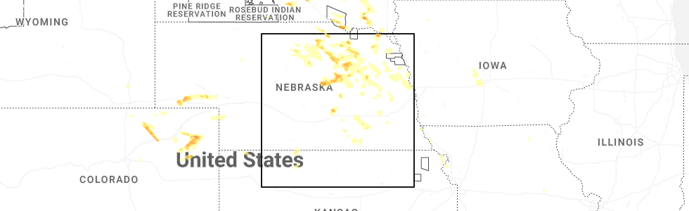
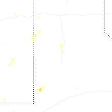
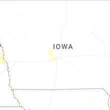
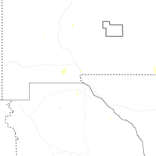
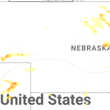
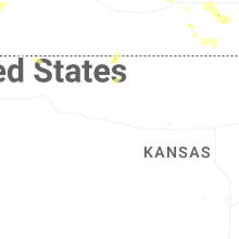
Hail Map for Monday, July 7, 2025
Number of Impacted Households on 7/7/2025
0
Impacted by 1" or Larger Hail
0
Impacted by 1.75" or Larger Hail
0
Impacted by 2.5" or Larger Hail
Square Miles of Populated Area Impacted on 7/7/2025
0
Impacted by 1" or Larger Hail
0
Impacted by 1.75" or Larger Hail
0
Impacted by 2.5" or Larger Hail

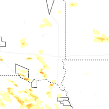
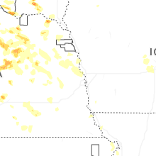
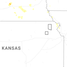
Cities Most Affected by Hail Storms of 7/7/2025
| Hail Size | Demographics of Zip Codes Affected | ||||||
|---|---|---|---|---|---|---|---|
| City | Count | Average | Largest | Pop Density | House Value | Income | Age |
| Adams, ND | 3 | 2.17 | 2.50 | 1 | $21k | $31.3k | 52.3 |
| Wynot, NE | 2 | 2.38 | 3.00 | 5 | $38k | $30.2k | 46.8 |
| Wagner, SD | 2 | 1.88 | 2.00 | 5 | $56k | $23.6k | 34.9 |
| Lankin, ND | 1 | 3.50 | 3.50 | 2 | $27k | $29.2k | 51.8 |
| Winnetoon, NE | 1 | 2.00 | 2.00 | 2 | $19k | $18.0k | 51.0 |
| Manvel, ND | 1 | 1.75 | 1.75 | 7 | $73k | $48.4k | 38.1 |
| Lesterville, SD | 1 | 1.75 | 1.75 | 4 | $33k | $36.9k | 44.3 |
| Sidney, NE | 1 | 1.75 | 1.75 | 18 | $61k | $34.3k | 38.2 |
| Menno, SD | 1 | 1.75 | 1.75 | 5 | $31k | $29.3k | 53.7 |
Hail and Wind Damage Spotted on 7/7/2025
Filter by Report Type:Hail ReportsWind Reports
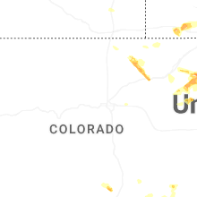
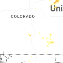
States Impacted
Colorado, New York, Virginia, Ohio, Nebraska, Pennsylvania, Missouri, North Dakota, South Carolina, South Dakota, Arkansas, Mississippi, Minnesota, Oklahoma, IowaColorado
| Local Time | Report Details |
|---|---|
| 12:49 PM MDT | Storm damage reported in arapahoe county CO, 14 miles SSE of Denver, CO |
| 4:09 PM MDT | Storm damage reported in washington county CO, 25.4 miles W of Yuma, CO |
| 4:25 PM MDT | Ping Pong Ball sized hail reported near Otis, CO, 12.7 miles W of Yuma, CO |
| 4:30 PM MDT | 8 or 9 power poles down between cr45 and cr 47. highway 59 sb is also closed in that area as well for restoration of the powerline in yuma county CO, 7.7 miles N of Yuma, CO |
| 4:45 PM MDT | Quarter sized hail reported near Yuma, CO, 0.4 miles WNW of Yuma, CO, quarter size hail ongoing in yuma. |
| 4:47 PM MDT | Kcoyuma34 weatherunderground sit in yuma county CO, 1.6 miles NNE of Yuma, CO |
| 4:51 PM MDT | Quarter sized hail reported near Yuma, CO, 6.5 miles NNW of Yuma, CO, good variety of hail sizes with quarter estimated to be the highest. |
| 4:53 PM MDT | Weatherlink site rdm cattl in yuma county CO, 10.1 miles NE of Yuma, CO |
| 5:25 PM MDT | Report of some powerlines down south of wray; unknown on exact location and how many as of no in yuma county CO, 26.4 miles E of Yuma, CO |
| 5:25 PM MDT | K2v in yuma county CO, 25.6 miles E of Yuma, CO |
| 5:26 PM MDT | Spotter network report of 60 mph wind gust via a handheld anemomete in yuma county CO, 26.8 miles E of Yuma, CO |
| 5:27 PM MDT | Kcowray2 in yuma county CO, 23.6 miles E of Yuma, CO |
| 5:35 PM MDT | Corrects previous tstm wnd gst report from 2 nnw wray. k2v in yuma county CO, 25.6 miles E of Yuma, CO |
| 5:35 PM MDT | K3v in yuma county CO, 25.6 miles E of Yuma, CO |
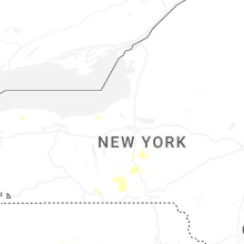
New York
| Local Time | Report Details |
|---|---|
| 3:02 PM EDT | Power line down across north beaver and water street in onondaga county NY, 16.4 miles W of Syracuse, NY |
| 3:02 PM EDT | Trees and wires down on water street and beaver stree in onondaga county NY, 16.4 miles W of Syracuse, NY |
| 3:22 PM EDT | A few trees down along glenburn rd. one tree took down wires and a pole with a small transformer. the pole and wires landed on a car... smashing the windshield and caus in onondaga county NY, 7.2 miles NNW of Syracuse, NY |
| 3:22 PM EDT | Wires down on morgan and buckley road in onondaga county NY, 5.2 miles NW of Syracuse, NY |
| 3:22 PM EDT | Small tree down on morgan roa in onondaga county NY, 8.9 miles NNW of Syracuse, NY |
| 3:41 PM EDT | Wires down neare route 31 and button roa in onondaga county NY, 9.1 miles N of Syracuse, NY |
| 3:48 PM EDT | Drees and power lines down on shibley road. time estimated from rada in lewis county NY, 57 miles NE of Syracuse, NY |
| 3:48 PM EDT | Trees and power lines down on shibley road. time estimated from rada in lewis county NY, 57 miles NE of Syracuse, NY |
| 3:54 PM EDT | Tree in roadwa in oswego county NY, 27.7 miles NW of Syracuse, NY |
| 4:15 PM EDT | Wires down on kennedy roa in onondaga county NY, 4.9 miles S of Syracuse, NY |
| 4:22 PM EDT | Tree and wires down near clark reservation state par in onondaga county NY, 5.7 miles SE of Syracuse, NY |
| 4:30 PM EDT | Wires down on route 9 in onondaga county NY, 9.2 miles ESE of Syracuse, NY |
| 5:02 PM EDT | Trees and wires down over old groton roa in cortland county NY, 32.3 miles S of Syracuse, NY |
| 5:07 PM EDT | Large tree fallen on property via social media phot in steuben county NY, 86.7 miles SW of Syracuse, NY |
| 5:25 PM EDT | Tree down at the corner of lilac drive and aster driv in chemung county NY, 70.5 miles SSW of Syracuse, NY |
| 5:26 PM EDT | Large willow tree blocking one lane of traffic on prospect stree in tompkins county NY, 45.6 miles SSW of Syracuse, NY |
| 5:31 PM EDT | Tree fallen on property on sing sing roa in chemung county NY, 71 miles SSW of Syracuse, NY |
| 5:31 PM EDT | Large tree over hickory grove road via social media phot in chemung county NY, 69.9 miles SSW of Syracuse, NY |
| 5:35 PM EDT | Trees and wires down on watkins roa in chemung county NY, 69.4 miles SSW of Syracuse, NY |
| 5:44 PM EDT | Trees and wires down on east franklin stree in chemung county NY, 69.5 miles SSW of Syracuse, NY |
| 5:45 PM EDT | Trees down over shamrock roa in chemung county NY, 66.5 miles SSW of Syracuse, NY |
| 5:59 PM EDT | Trees and wires down on jones roa in chemung county NY, 69.1 miles SSW of Syracuse, NY |
| 6:00 PM EDT | Media relayed report of strong winds and several snapped power poles on muckey r in cortland county NY, 40.9 miles S of Syracuse, NY |
Virginia
| Local Time | Report Details |
|---|---|
| 3:12 PM EDT | Tree down on rockfish valley highway at avon roa in nelson county VA, 73.1 miles WNW of Richmond, VA |
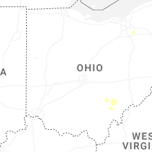
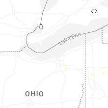
Ohio
| Local Time | Report Details |
|---|---|
| 3:46 PM EDT | Several 3 inch tree limbs down. time estimated via rada in summit county OH, 25.4 miles SSE of Cleveland, OH |
| 3:56 PM EDT | Delayed report; time estimated by radar; spotter reported roof damage near the intersection of smith and cartse in medina county OH, 28.8 miles SSW of Cleveland, OH |
| 4:01 PM EDT | Tree down. time estimated via rada in trumbull county OH, 62.2 miles NNW of Pittsburgh, PA |
| 4:04 PM EDT | Tree down. time estimated via rada in trumbull county OH, 62.3 miles NNW of Pittsburgh, PA |
| 5:26 PM EDT | Report of multiple wires down in the area. time estimated based on rada in columbiana county OH, 47 miles WNW of Pittsburgh, PA |
| 5:32 PM EDT | Corrects previous tstm wnd dmg report from lisbon. report of multiple wires down in the area. time estimated based on rada in columbiana county OH, 47 miles WNW of Pittsburgh, PA |
| 5:59 PM EDT | Large tree down on blackwater road. time estimated from rada in ross county OH, 34.9 miles S of Columbus, OH |
| 5:59 PM EDT | Trees and power lines down at crouse chapel road and 159. time estimated from rada in ross county OH, 36.1 miles S of Columbus, OH |
| 7:37 PM EDT | Tree down across kasler creek road. time estimated from radar. reprt time was 740 p in athens county OH, 65.7 miles ESE of Columbus, OH |
| 7:50 PM EDT | Tree down along buttermilk hill road 3 miles nnw of mcconnelsville. time estimated via rada in morgan county OH, 63.1 miles ESE of Columbus, OH |
| 7:55 PM EDT | Tree down along buckeye ridge road. time estimated via rada in morgan county OH, 70 miles ESE of Columbus, OH |
| 8:02 PM EDT | Three large trees down along route 266. time estimated via radar. also water over road... but likely due to a blocked culver in morgan county OH, 70.1 miles ESE of Columbus, OH |
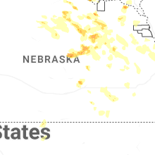
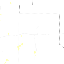
Nebraska
| Local Time | Report Details |
|---|---|
| 3:01 PM CDT | Quarter sized hail reported near , , 35.6 miles SSE of Grand Island, NE, report on social media of quarter sized hail in fairfield. |
| 4:21 PM MDT | Golf Ball sized hail reported near Sidney, NE, 54 miles SSE of Scottsbluff, NE, fire chief reports golf ball size hail. |
| 5:46 PM CDT | Hen Egg sized hail reported near Winnetoon, NE, 32 miles E of Oneill, NE, hail nearing tennis ball-size from chaser live stream. time estimated from radar on highway 14 west of winnetoon. |
| 4:55 PM MDT | Quarter sized hail reported near Lodgepole, NE, 67.4 miles SE of Scottsbluff, NE, trained spotter reports quarter size hail. |
| 6:19 PM CDT | Ping Pong Ball sized hail reported near Wood River, NE, 11.6 miles W of Grand Island, NE, quarter to ping pong ball size hail was reported. |
| 5:27 PM MDT | Ping Pong Ball sized hail reported near Oshkosh, NE, 71.6 miles ESE of Scottsbluff, NE |
| 6:30 PM CDT | Quarter sized hail reported near Belden, NE, 73.6 miles E of Oneill, NE, report of mix of quarters and dime sized hail. |
| 7:00 PM CDT | Golf Ball sized hail reported near Wynot, NE, 60.3 miles SSW of Sioux Falls, SD |
| 7:15 PM CDT | Tea Cup sized hail reported near Wynot, NE, 61.1 miles SSW of Sioux Falls, SD, 3 to 3.5 inch diameter hail. |
| 7:51 PM CDT | Quarter sized hail reported near Pierce, NE, 49.8 miles ESE of Oneill, NE, mix of nickel to quarter size hail at 7:51 pm. |
| 8:23 PM CDT | Half Dollar sized hail reported near Spalding, NE, 50.1 miles N of Grand Island, NE, some of the hail was quarter to half dollar size. |
| 8:40 PM CDT | Quarter sized hail reported near Clearwater, NE, 30.8 miles SE of Oneill, NE, mostly penny to nickel sized hail... but a few quarter sized stones. |
| 9:16 PM CDT | Corrects previous tstm wnd gst report from 2 ese tekama in burt county NE, 36.6 miles NNW of Omaha, NE |
| 9:18 PM CDT | Storm damage reported in burt county NE, 36.6 miles NNW of Omaha, NE |
| 9:50 PM CDT | Storm damage reported in douglas county NE, 22.7 miles W of Omaha, NE |
| 9:52 PM CDT | Personal weather statio in washington county NE, 17.2 miles NNW of Omaha, NE |
| 9:58 PM CDT | Storm damage reported in washington county NE, 21.9 miles NNW of Omaha, NE |
| 10:00 PM CDT | Storm damage reported in douglas county NE, 8.2 miles NNW of Omaha, NE |
| 10:03 PM CDT | Personal weather statio in douglas county NE, 12.1 miles WNW of Omaha, NE |
| 10:09 PM CDT | Storm damage reported in douglas county NE, 7 miles NW of Omaha, NE |
| 10:14 PM CDT | Storm damage reported in sarpy county NE, 9.4 miles SSW of Omaha, NE |
| 10:16 PM CDT | Personal weather statio in douglas county NE, 14.2 miles WSW of Omaha, NE |
| 10:17 PM CDT | Personal weather statio in douglas county NE, 15.2 miles WSW of Omaha, NE |
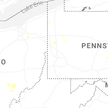
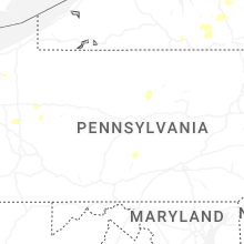
Pennsylvania
| Local Time | Report Details |
|---|---|
| 4:11 PM EDT | Report of a tree falling behind building in alleyway near ormond avenue. time estimated based on rada in mercer county PA, 60.6 miles NNW of Pittsburgh, PA |
| 4:12 PM EDT | Report of tree down along walnut road that ripped powerlines off house. time estimated based on rada in mercer county PA, 61.9 miles NNW of Pittsburgh, PA |
| 4:13 PM EDT | Report of tree onto house along 3rd street and through the roof. time estimated based on rada in mercer county PA, 62.1 miles NNW of Pittsburgh, PA |
| 4:16 PM EDT | Report of a tree down blocking one side of dutch lane. time estimated based on rada in mercer county PA, 60.4 miles NNW of Pittsburgh, PA |
| 4:58 PM EDT | Report of a tree down on a phone line along east river road. time estimated based on rada in lawrence county PA, 46.6 miles NNW of Pittsburgh, PA |
| 5:35 PM EDT | 911 call center reported tree down at melvin drive and north mercer street. time estimated from rada in lawrence county PA, 44.2 miles NNW of Pittsburgh, PA |
| 5:50 PM EDT | Tree down along lisbon roa in venango county PA, 54.2 miles N of Pittsburgh, PA |
| 6:09 PM EDT | Large tree down on hyner run road near the hyner lodge foundatio in clinton county PA, 43 miles NNE of State College, PA |
| 6:19 PM EDT | Tree down at the intersection of coudersport pike and pa-4 in clinton county PA, 42.3 miles NNE of State College, PA |
| 6:22 PM EDT | 911 call center reported wires down. time estimated from rada in butler county PA, 21.2 miles N of Pittsburgh, PA |
| 6:56 PM EDT | Multiple trees down in the vicinity of hunter hollow road and shirk hollow roa in clinton county PA, 33.3 miles NE of State College, PA |
| 6:59 PM EDT | Tree down on wires in the 300 block of little plum run roa in clinton county PA, 36.6 miles NE of State College, PA |
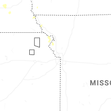
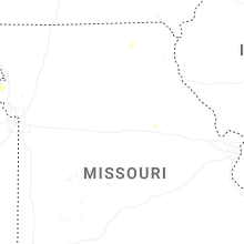
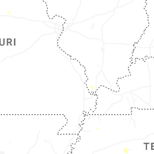
Missouri
| Local Time | Report Details |
|---|---|
| 3:20 PM CDT | Storm damage reported in callaway county MO, 24.2 miles E of Columbia, MO |
| 3:40 PM CDT | Billboards blown away and an rv tipped over at the i-70 rv center. multiple rvs damaged. time estimated from rada in callaway county MO, 28.8 miles E of Columbia, MO |
| 4:25 PM CDT | Very windy as the storm moved through. at least some small twigs downed in the parking lot. time estimated from rada in callaway county MO, 31.7 miles SE of Columbia, MO |
| 1:33 AM CDT | Storm damage reported in buchanan county MO, 49.4 miles NNW of Kansas City, MO |
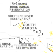
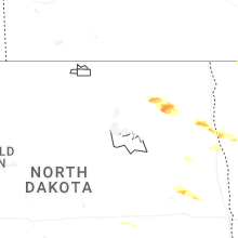
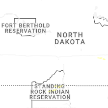
North Dakota
| Local Time | Report Details |
|---|---|
| 3:27 PM CDT | Quarter sized hail reported near Gilby, ND, 64.4 miles E of Devils Lake, ND, quarter sized hail reported by trained weather spotters. |
| 4:20 PM CDT | Golf Ball sized hail reported near Manvel, ND, 74.9 miles E of Devils Lake, ND |
| 4:47 PM CDT | Quarter sized hail reported near Grand Forks, ND, 74.1 miles N of Fargo, ND, report by faa weather observier... relayed by broadcast media. |
| 4:55 PM CDT | Quarter sized hail reported near Hope, ND, 56.2 miles WNW of Fargo, ND |
| 5:08 PM CDT | Half Dollar sized hail reported near Hope, ND, 55.5 miles WNW of Fargo, ND |
| 5:08 PM CDT | Hen Egg sized hail reported near Adams, ND, 41.1 miles ENE of Devils Lake, ND, photo via social media. |
| 5:10 PM CDT | Tennis Ball sized hail reported near Adams, ND, 35 miles ENE of Devils Lake, ND |
| 5:15 PM CDT | Golf Ball sized hail reported near Adams, ND, 39.5 miles ENE of Devils Lake, ND, video of windshield being damaged sent in by storm chaser. location estimated by radar. |
| 5:20 PM CDT | Tea Cup sized hail reported near Lankin, ND, 39.7 miles ENE of Devils Lake, ND |
| 6:15 PM CDT | Quarter sized hail reported near Manvel, ND, 77.7 miles E of Devils Lake, ND |
| 6:22 PM CDT | Quarter sized hail reported near Thompson, ND, 68 miles NNW of Fargo, ND, mostly dime to penny... some quarters mixed in. |
| 7:22 PM CDT | Quarter sized hail reported near Thompson, ND, 68 miles NNW of Fargo, ND, corrects previous hail report from 4 nnw thompson. mostly dime to penny... some quarters mixed in. |
| 7:31 PM CDT | Quarter sized hail reported near Grand Forks, ND, 68.4 miles NNW of Fargo, ND, report from mping: quarter (1.00 in.). |
| 7:56 PM CDT | Bin damage... broken trees... hayloft door missing... and trampoline in the tree in grand forks county ND, 57.2 miles N of Fargo, ND |
South Carolina
| Local Time | Report Details |
|---|---|
| 4:48 PM EDT | Tree down on pine grove road near the intersection with benton farm road. this was due to thunderstorm outflow. time estimated by rada in colleton county SC, 50.1 miles WSW of Charleston, SC |
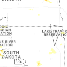
South Dakota
| Local Time | Report Details |
|---|---|
| 3:50 PM CDT | Quarter sized hail reported near Winner, SD, 49.7 miles NE of Valentine, NE |
| 3:51 PM CDT | Quarter sized hail reported near Winner, SD, 49.6 miles NE of Valentine, NE |
| 4:01 PM CDT | Storm damage reported in tripp county SD, 50.3 miles NE of Valentine, NE |
| 4:14 PM CDT | Quarter sized hail reported near Wagner, SD, 41.3 miles NNE of Oneill, NE, not very much hail... but some stones as big as a quarter. heavy rain also occurred. |
| 4:37 PM CDT | Quarter sized hail reported near Hayti, SD, 77 miles WSW of Montevideo, MN |
| 4:54 PM CDT | Golf Ball sized hail reported near Wagner, SD, 41.8 miles NNE of Oneill, NE, heavy rainfall and various sizes of hail up to golfball for about 8 minutes. |
| 5:25 PM CDT | Hen Egg sized hail reported near Wagner, SD, 36.2 miles NE of Oneill, NE, photo of lime-sized hail via social media. |
| 5:45 PM CDT | Golf Ball sized hail reported near Menno, SD, 47.6 miles WSW of Sioux Falls, SD, rachell sandow called to report golf ball hail in menno. |
| 5:50 PM CDT | Golf Ball sized hail reported near Lesterville, SD, 51.9 miles SW of Sioux Falls, SD, heavy rain and hail up to the sized of golf balls. |
| 6:00 PM CDT | Mesonet station 163 sd rwis freema in hutchinson county SD, 39.2 miles WSW of Sioux Falls, SD |
| 6:45 PM CDT | Awos station kykn yankton municipal airpor in yankton county SD, 53.9 miles SW of Sioux Falls, SD |
| 7:08 PM CDT | Em estimating a wind gust around 60 mph at the intersection of 455th ave and 306th s in clay county SD, 45.1 miles SSW of Sioux Falls, SD |
| 7:09 PM CDT | Mesonet station 197 sd rwis gayvill in yankton county SD, 52.1 miles SSW of Sioux Falls, SD |
| 7:56 PM CDT | A few very strong thunderstorm winds broke two large branches out of healthy tree... and then very heavy rain starte in union county SD, 54.9 miles S of Sioux Falls, SD |
| 8:05 PM CDT | Estimated 50-60 mph wind gusts from police officer. sporatic power outages due to tree damage around tow in union county SD, 59.1 miles S of Sioux Falls, SD |
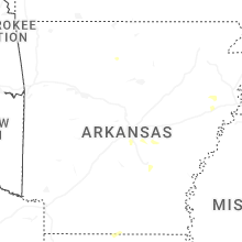
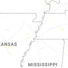
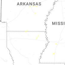
Arkansas
| Local Time | Report Details |
|---|---|
| 4:02 PM CDT | Large trees across the roa in jefferson county AR, 41.2 miles SSE of Little Rock, AR |
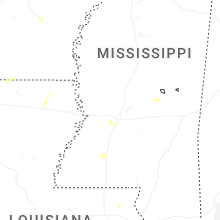
Mississippi
| Local Time | Report Details |
|---|---|
| 4:50 PM CDT | A tree was blown down on zetus roa in lincoln county MS, 54.8 miles SSW of Jackson, MS |
| 6:30 PM CDT | Skirting was blown off a mobile home. trees and power lines were also blown dow in hinds county MS, 10.8 miles WSW of Jackson, MS |
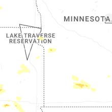
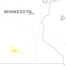
Minnesota
| Local Time | Report Details |
|---|---|
| 4:50 PM CDT | Quarter sized hail reported near East Grand Forks, MN, 80.7 miles SW of Roseau, MN |
| 5:14 PM CDT | Pictures of multiple 1-3 inch tree limbs... and one 4-5 inch limb down near greenway porta in grand forks county ND, 73.7 miles N of Fargo, ND |
| 5:20 PM CDT | Multiple tree limbs up to 6 inch in size dow in polk county MN, 70.4 miles N of Fargo, ND |
| 7:16 PM CDT | Quarter sized hail reported near Euclid, MN, 72.9 miles N of Fargo, ND |
| 7:18 PM CDT | Photos sent in of large tree branches snapped at a home west of leavenwort in brown county MN, 66.9 miles SE of Montevideo, MN |
| 7:35 PM CDT | Tree fell on a power line... taking out power in godah in watonwan county MN, 78.8 miles SE of Montevideo, MN |
| 7:36 PM CDT | 6 trees on a wind break were blown over at a farm on 220th av in brown county MN, 78.5 miles SE of Montevideo, MN |
Oklahoma
| Local Time | Report Details |
|---|---|
| 5:10 PM CDT | Storm damage reported in rogers county OK, 32 miles NNE of Tulsa, OK |
Iowa
| Local Time | Report Details |
|---|---|
| 8:28 PM CDT | Asos station ksux sioux gateway airpor in woodbury county IA, 63 miles WSW of Storm Lake, IA |
| 10:12 PM CDT | Large branches dow in pottawattamie county IA, 4.4 miles ESE of Omaha, NE |
| 10:15 PM CDT | Storm damage reported in pottawattamie county IA, 10 miles E of Omaha, NE |
| 11:24 PM CDT | Pw in cass county IA, 46.1 miles E of Omaha, NE |
| 11:32 PM CDT | Personal weather statio in montgomery county IA, 54.5 miles ESE of Omaha, NE |
| 12:10 AM CDT | Pw in taylor county IA, 70.8 miles SW of Des Moines, IA |
| 12:25 AM CDT | Two personal weather stations reported 72 and 74 mph gusts at 125 and 1230 am... respectively. small microburst signature on rada in polk county IA, 9.7 miles N of Des Moines, IA |
Connect with Interactive Hail Maps