

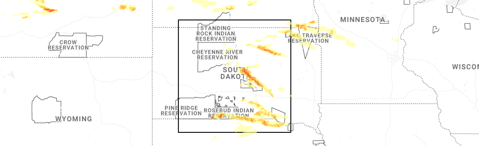
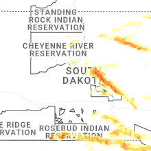
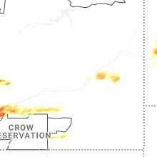
Hail Map for Monday, July 28, 2025
Number of Impacted Households on 7/28/2025
0
Impacted by 1" or Larger Hail
0
Impacted by 1.75" or Larger Hail
0
Impacted by 2.5" or Larger Hail
Square Miles of Populated Area Impacted on 7/28/2025
0
Impacted by 1" or Larger Hail
0
Impacted by 1.75" or Larger Hail
0
Impacted by 2.5" or Larger Hail

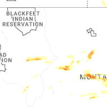
Cities Most Affected by Hail Storms of 7/28/2025
| Hail Size | Demographics of Zip Codes Affected | ||||||
|---|---|---|---|---|---|---|---|
| City | Count | Average | Largest | Pop Density | House Value | Income | Age |
Hail and Wind Damage Spotted on 7/28/2025
Filter by Report Type:Hail ReportsWind Reports
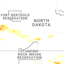
North Dakota
| Local Time | Report Details |
|---|---|
| 6:20 AM MDT | 50-60 mph winds reported. torrential rainfall... pea size hail... and frequent lightning also were reporte in billings county ND, 65.4 miles SSE of Williston, ND |
| 6:35 AM MDT | Photo on social media shows multiple 115 kv power lines down 4n6w of fairfield. time estimated by radar... and in association with a 75 mph wind gust reported by the fa in billings county ND, 68.2 miles SSE of Williston, ND |
| 6:35 AM MDT | Ndawn 2w fairfield report at 10 meters... 62 mph at the surfac in billings county ND, 72.5 miles SSE of Williston, ND |
| 7:08 AM MDT | Davis weather station observation. peak wind gus in dunn county ND, 76.9 miles SSE of Williston, ND |
| 7:10 AM MDT | Ndawn mesonet statio in dunn county ND, 80.8 miles SSE of Williston, ND |
| 7:15 AM MDT | Observation relayed through emergency manage in stark county ND, 96.5 miles SSE of Williston, ND |
| 7:30 AM MDT | Emergency management relays a photo of a medium to large tree branch felled. time estimated by radar... and in association with a report of a 65 mph wind gust in dickin in stark county ND, 95.2 miles SSE of Williston, ND |
| 1:30 PM UTC | Emergency manager relays a picture of a split medium-sized tree. split occurred near a forked section of the tree. time estimated by radar... and in association with a in stark county ND, 95 miles W of Bismarck, ND |
| 7:30 AM MDT | Gladstone nd dot observation sit in stark county ND, 84.1 miles W of Bismarck, ND |
| 7:30 AM MDT | Wind gusts estimated 65-70 mph. very heavy rai in stark county ND, 95.5 miles W of Bismarck, ND |
| 8:05 AM MDT | Private weather station peak wind gus in stark county ND, 66.7 miles W of Bismarck, ND |
| 9:35 AM CDT | Awos station kd57 glen ulli in morton county ND, 51.7 miles W of Bismarck, ND |
| 10:54 AM CDT | Private weather sensor south side of bismarck. most wind reports in the bismarck/mandan area were up to around 50 mp in burleigh county ND, 3.3 miles SSW of Bismarck, ND |
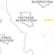
Montana
| Local Time | Report Details |
|---|---|
| 9:00 AM MDT | Quarter sized hail reported near Ismay, MT, 49.8 miles E of Miles City, MT |
| 2:36 PM MDT | Quarter sized hail reported near Clancy, MT, 71.7 miles NW of Bozeman, MT, trained spotter reports hail slightly larger than quarter sized. |
Tennessee
| Local Time | Report Details |
|---|---|
| 2:15 PM EDT | Several trees dow in greene county TN, 41.3 miles SW of Bristol, TN |
North Carolina
| Local Time | Report Details |
|---|---|
| 7:30 PM UTC | Fire department dispatched at 429 pm to remove a fallen tree at olive branch rd. and christian light rd. time of event estimated from rada in harnett county NC, 25.3 miles SSW of Raleigh, NC |
| 7:53 PM UTC | Duke energy outage caused by damaged equipment from fallen trees or limb in harnett county NC, 29.5 miles SSW of Raleigh, NC |
Michigan
| Local Time | Report Details |
|---|---|
| 3:36 PM EDT | Numerous downed power lines in the romulus are in wayne county MI, 56.9 miles SSE of Flint, MI |
Connect with Interactive Hail Maps