

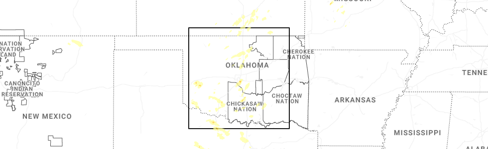
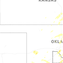
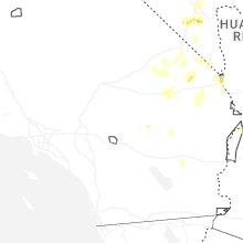
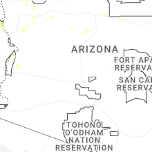
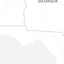
Hail Map for Tuesday, June 3, 2025
Number of Impacted Households on 6/3/2025
0
Impacted by 1" or Larger Hail
0
Impacted by 1.75" or Larger Hail
0
Impacted by 2.5" or Larger Hail
Square Miles of Populated Area Impacted on 6/3/2025
0
Impacted by 1" or Larger Hail
0
Impacted by 1.75" or Larger Hail
0
Impacted by 2.5" or Larger Hail
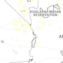
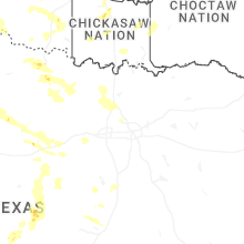
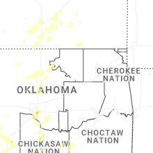


Cities Most Affected by Hail Storms of 6/3/2025
| Hail Size | Demographics of Zip Codes Affected | ||||||
|---|---|---|---|---|---|---|---|
| City | Count | Average | Largest | Pop Density | House Value | Income | Age |
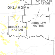
| Newcastle, OK | 1 | 1.75 | 1.75 | 131 | $92k | $48.7k | 39.0 |
| Windthorst, TX | 1 | 1.75 | 1.75 | 4 | $73k | $36.8k | 36.8 |
Hail and Wind Damage Spotted on 6/3/2025
Filter by Report Type:Hail ReportsWind Reports
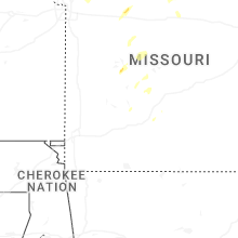
States Impacted
Kansas, Illinois, Wisconsin, Florida, Oklahoma, Missouri, Texas, Nevada, Iowa, New MexicoKansas
| Local Time | Report Details |
|---|---|
| 12:21 PM CDT | Quarter sized hail reported near El Dorado, KS, 27.9 miles ENE of Wichita, KS |
| 12:38 PM CDT | Quarter sized hail reported near Wichita, KS, 3.5 miles SSE of Wichita, KS |
| 1:40 PM CDT | Power pole dow in franklin county KS, 37.6 miles SW of Kansas City, MO |
| 1:42 PM CDT | Downed trees and wires east of wellsville. time estimated from rada in miami county KS, 35.9 miles SW of Kansas City, MO |
| 1:45 PM CDT | Downed tree at intersection of high prairie road and 187th street. time estimated from rada in leavenworth county KS, 25.7 miles WNW of Kansas City, MO |
| 1:45 PM CDT | Several reports of downed wires and tree limbs near hillsdale recreation area. time estimated from rada in miami county KS, 38 miles SW of Kansas City, MO |
| 1:49 PM CDT | Downed wires and power outages near 7th street. time estimated from rada in leavenworth county KS, 23.5 miles NW of Kansas City, MO |
| 2:02 PM CDT | Downed wires and power outages near gilman road. time estimated from rada in leavenworth county KS, 18.7 miles WNW of Kansas City, MO |
| 2:02 PM CDT | Social media photo of a large tree uprooted in olathe. time estimated from rada in johnson county KS, 19.1 miles SW of Kansas City, MO |
| 2:05 PM CDT | Downed tree on tontine road near route 5. time estimated from rada in leavenworth county KS, 16 miles WNW of Kansas City, MO |
| 2:09 PM CDT | Several reports of downed tree limbs in the stanley and heritage park areas. time estimated from rada in johnson county KS, 21.1 miles SSW of Kansas City, MO |
| 2:12 PM CDT | Social media video of a tree down at a residence in overland park. time estimated from rada in johnson county KS, 8.8 miles SSW of Kansas City, MO |
| 2:12 PM CDT | Downed tree and wires near 82nd street. time estimated from rada in wyandotte county KS, 10.1 miles W of Kansas City, MO |
| 2:12 PM CDT | Downed tree and wires near elizabeth avenue. time estimated from rada in wyandotte county KS, 10.1 miles W of Kansas City, MO |
| 2:16 PM CDT | Downed tree and wires near cleveland avenue. time estimated from rada in wyandotte county KS, 7.6 miles WNW of Kansas City, MO |
| 2:16 PM CDT | Downed wires and power outages reported north of leawood. time estimated from rada in johnson county KS, 7.9 miles S of Kansas City, MO |
| 2:16 PM CDT | Semi blown over on i-635 near parallel parkway. time estimated from rada in wyandotte county KS, 5.5 miles WNW of Kansas City, MO |
| 2:16 PM CDT | Downed wires near greeley avenue. time estimated from rada in wyandotte county KS, 7.1 miles WNW of Kansas City, MO |
| 2:19 PM CDT | Downed tree and wires near 17th street. time estimated from rada in wyandotte county KS, 3.6 miles W of Kansas City, MO |
| 2:19 PM CDT | Downed tree onto a building near the ku medical center. social media report and photo. time estimated from rada in wyandotte county KS, 3.9 miles SSW of Kansas City, MO |
| 2:26 PM CDT | Downed power lines near 151st and pflumm. time estimated from rada in johnson county KS, 19.4 miles SSW of Kansas City, MO |
Illinois
| Local Time | Report Details |
|---|---|
| 12:57 PM CDT | Report of multiple downed wires around rockford. relayed via broadcast media... time estimated by rada in winnebago county IL, 57.4 miles SSE of Madison, WI |
| 1:00 PM CDT | Photo shared to social media shows tree branch downed into street in southeast side of rockford. time estimated by rada in winnebago county IL, 60.3 miles SSE of Madison, WI |
| 1:02 PM CDT | Large tree branch downed along guilford road near midway village museum in rockford. time estimated by rada in winnebago county IL, 58.5 miles SSE of Madison, WI |
| 1:29 PM CDT | Trained spotter reported 65 mph gust south of harvard. relayed via social medi in mchenry county IL, 61.2 miles SE of Madison, WI |
| 1:30 PM CDT | Ildot station southwest of marengo reported 61 mph gus in mchenry county IL, 58.6 miles WNW of Chicago, IL |
| 1:30 PM CDT | Power lines damaged along harmony road south of marengo. relayed via broadcast media... time estimated by rada in mchenry county IL, 54.3 miles WNW of Chicago, IL |
| 1:30 PM CDT | Downed power lines and tree branches in harvard. time estimated by rada in mchenry county IL, 59.9 miles SE of Madison, WI |
| 1:55 PM CDT | Chapel road blocked by 30-36 inch diameter tree broken. time estimated by rada in mchenry county IL, 37.3 miles WNW of Chicago, IL |
| 6:35 PM CDT | Large tree branches down throughout town... some whole trees down. time estimated from radar dat in mercer county IL, 64.3 miles NE of Kahoka, MO |
| 6:48 PM CDT | 50 to 60 mph wind gusts with torrential rain. relayed from ham radi in warren county IL, 57.5 miles WNW of Peoria, IL |
| 6:55 PM CDT | Wind gust of 60 mph recorded on home weather statio in whiteside county IL, 78.4 miles E of Cedar Rapids, IA |
| 7:01 PM CDT | Numerous tree branches dow in rock island county IL, 68 miles SE of Cedar Rapids, IA |
| 7:02 PM CDT | Grain bins damaged. possible tornado. time estimated from radar dat in rock island county IL, 64.3 miles SE of Cedar Rapids, IA |
| 7:05 PM CDT | Widespread wind damage with reports of shed roofs ripped off and large trees dow in warren county IL, 56.9 miles WNW of Peoria, IL |
| 7:10 PM CDT | One half of large tree down. time estimated from radar informatio in rock island county IL, 62.9 miles SE of Cedar Rapids, IA |
| 7:10 PM CDT | Significant damage to mobile homes. time estimated based on rada in rock island county IL, 69.2 miles SE of Cedar Rapids, IA |
| 7:10 PM CDT | Numerous trees down. possible tornado. time estimated from radar dat in rock island county IL, 69.6 miles SE of Cedar Rapids, IA |
| 7:12 PM CDT | Power pole broken off. relayed by media. time estimated from radar dat in rock island county IL, 66.3 miles SE of Cedar Rapids, IA |
| 7:22 PM CDT | Large tree dow in rock island county IL, 70.6 miles ESE of Cedar Rapids, IA |
| 7:28 PM CDT | 12 power poles snapped off. time estimated from radar informatio in rock island county IL, 72.2 miles NW of Peoria, IL |
| 8:15 PM CDT | Time estimate by radar. power lines have been downed by the thunderstorm wind in whiteside county IL, 69 miles N of Peoria, IL |
| 8:49 PM CDT | Private weather station kilroche34 reported 58 mph gust northwest of hillcres in ogle county IL, 75.9 miles W of Chicago, IL |
Wisconsin
| Local Time | Report Details |
|---|---|
| 1:28 PM CDT | Trees and limbs down in southwest walworth county. time estimated from rada in walworth county WI, 51.1 miles SE of Madison, WI |
| 1:35 PM CDT | Tree down in delavan. time estimated from rada in walworth county WI, 49.1 miles SE of Madison, WI |
| 1:37 PM CDT | Report of small tree limbs down and estimated wind speeds to 60 mp in walworth county WI, 46.9 miles SE of Madison, WI |
| 1:49 PM CDT | Large tree branch down on clover rd in bloomfield... wi. time estimated based on rada in walworth county WI, 58.7 miles NW of Chicago, IL |
| 10:15 PM CDT | 59 mph gust measured at kenosha regional arpt. time confirmed via radar dat in kenosha county WI, 51.1 miles NNW of Chicago, IL |
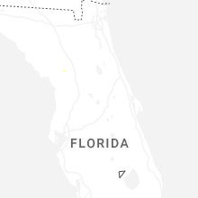
Florida
| Local Time | Report Details |
|---|---|
| 2:50 PM EDT | A tree fell onto the interstate 95 northbound blocking the middle and right lanes near at mile marker 320 which is south of international golf parkway and north of stat in st. johns county FL, 27.8 miles SSE of Jacksonville, FL |
| 5:05 PM EDT | Tree down on doctor martin luther king jr memorial roa in wakulla county FL, 18.6 miles S of Tallahassee, FL |
| 5:10 PM EDT | Tree down near the intersection of navajo trail and spring creek highwa in wakulla county FL, 18 miles S of Tallahassee, FL |
| 5:14 PM EDT | Fallen trees or limbs resulted in a power outage along eddins lan in wakulla county FL, 22.7 miles SSW of Tallahassee, FL |
| 5:22 PM EDT | Fallen trees or limbs resulted in a power outage along dogwood driv in wakulla county FL, 18.9 miles SSW of Tallahassee, FL |
Oklahoma
| Local Time | Report Details |
|---|---|
| 2:00 PM CDT | Storm damage reported in beckham county OK, 75.4 miles S of Woodward, OK |
| 2:47 PM CDT | Storm damage reported in washita county OK, 84.4 miles W of Oklahoma City, OK |
| 2:55 PM CDT | 3-inch tree branches broken. mping report. time estimated from rada in kiowa county OK, 76.1 miles ENE of Childress, TX |
| 3:20 PM CDT | Storm damage reported in jackson county OK, 51.6 miles ENE of Childress, TX |
| 3:48 PM CDT | Golf Ball sized hail reported near Newcastle, OK, 15 miles SSW of Oklahoma City, OK |
| 3:48 PM CDT | Half Dollar sized hail reported near Newcastle, OK, 15 miles SSW of Oklahoma City, OK, corrects previous hail report from 2 nw newcastle. |
| 4:04 PM CDT | Quarter sized hail reported near Oklahoma City, OK, 8.4 miles S of Oklahoma City, OK, report from mping: quarter (1.00 in.). |
| 4:05 PM CDT | Storm damage reported in kingfisher county OK, 30.9 miles NW of Oklahoma City, OK |
| 4:09 PM CDT | Storm damage reported in kingfisher county OK, 30.9 miles NW of Oklahoma City, OK |
| 4:11 PM CDT | Quarter sized hail reported near Oklahoma City, OK, 8.5 miles SE of Oklahoma City, OK, report from mping: quarter (1.00 in.). |
| 4:11 PM CDT | Half Dollar sized hail reported near Oklahoma City, OK, 8.7 miles SE of Oklahoma City, OK, report from mping: half dollar (1.25 in.). |
| 4:11 PM CDT | Half Dollar sized hail reported near Oklahoma City, OK, 7.2 miles SE of Oklahoma City, OK |
| 4:19 PM CDT | Kti in oklahoma county OK, 8.7 miles ESE of Oklahoma City, OK |
| 4:49 PM CDT | Roof damage. mping report. time estimated from rada in oklahoma county OK, 5.2 miles WNW of Oklahoma City, OK |
| 4:50 PM CDT | 3-inch tree branches broken. mping report. time estimated from rada in comanche county OK, 53.5 miles N of Wichita Falls, TX |
| 5:01 PM CDT | Spotter network repor in grady county OK, 19.3 miles SSW of Oklahoma City, OK |
| 5:10 PM CDT | Power poles snapped/broken. mping report. time estimated from rada in cotton county OK, 20.3 miles N of Wichita Falls, TX |
| 5:40 PM CDT | Significant tree damage along with damage to a garage and outbuildings along county road 3210. possible tornado. time is estimated from rada in garvin county OK, 63.7 miles SSE of Oklahoma City, OK |
| 5:48 PM CDT | Quarter sized hail reported near Tecumseh, OK, 29.4 miles SE of Oklahoma City, OK, report from mping: quarter (1.00 in.). |
| 5:50 PM CDT | Quarter sized hail reported near Macomb, OK, 29.8 miles SE of Oklahoma City, OK, report from mping: quarter (1.00 in.). |
| 7:05 PM CDT | Reports of 14 inch tree limbs snapped near the ada walmart. time estimated from rada in pontotoc county OK, 41.2 miles NW of Atoka, OK |
| 7:05 PM CDT | Damage to barns and trees near cr 1650 and cr 3430 west of rof in pontotoc county OK, 46.9 miles WNW of Atoka, OK |
| 7:10 PM CDT | Numerous 3 to 4 inch branches down with a few 10 to 12 inch branche in murray county OK, 48.9 miles W of Atoka, OK |
| 7:10 PM CDT | Power poles snapped/broke in murray county OK, 49.4 miles W of Atoka, OK |
| 7:25 PM CDT | Fittstown (fitt) mesone in pontotoc county OK, 35.7 miles WNW of Atoka, OK |
| 8:47 PM CDT | Storm damage reported in atoka county OK, 1.3 miles WNW of Atoka, OK |
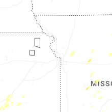
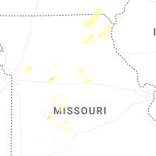
Missouri
| Local Time | Report Details |
|---|---|
| 2:09 PM CDT | Downed wires and power outages east of platte city. time estimated from rada in platte county MO, 19.9 miles NNW of Kansas City, MO |
| 2:19 PM CDT | Downed tree and wires near 70th street. time estimated from rada in jackson county MO, 7.1 miles S of Kansas City, MO |
| 2:23 PM CDT | Downed tree and wires near quincy avenue. time estimated from rada in jackson county MO, 3.9 miles SSE of Kansas City, MO |
| 2:23 PM CDT | Downed tree limbs and wires near 66th street. time estimated from rada in platte county MO, 8 miles NNW of Kansas City, MO |
| 2:23 PM CDT | Downed wires near robinhood lane. time estimated from rada in platte county MO, 7.6 miles NNW of Kansas City, MO |
| 2:26 PM CDT | Downed tree onto a vehicle near 47th and maywood. time estimated from rada in jackson county MO, 7.9 miles ESE of Kansas City, MO |
| 2:26 PM CDT | Semi blown over near i-435 and raytown road. multiple trees down east of this location. time estimated from rada in jackson county MO, 5.8 miles SE of Kansas City, MO |
| 2:27 PM CDT | Multiple reports of tree limbs and wires down in the raytown area. time estimated from rada in jackson county MO, 6.6 miles SE of Kansas City, MO |
| 2:30 PM CDT | Multiple reports of downed trees between independence and raytown. time estimated from rada in jackson county MO, 7.7 miles ESE of Kansas City, MO |
| 2:30 PM CDT | Em relayed images of large tree snapped/down just ne of intersection of 35th and crysler. time estimated from rada in jackson county MO, 8.7 miles ESE of Kansas City, MO |
| 2:30 PM CDT | Downed wires and power outages near crisp avenue. time estimated from rada in jackson county MO, 10.1 miles SE of Kansas City, MO |
| 2:30 PM CDT | Several downed or snapped trees near lees summit road. time estimated from rada in jackson county MO, 10.4 miles E of Kansas City, MO |
| 2:30 PM CDT | Downed wires near askew avenue. time estimated from rada in clay county MO, 8.4 miles NNE of Kansas City, MO |
| 2:34 PM CDT | Private weather senso in clay county MO, 21.2 miles N of Kansas City, MO |
| 2:35 PM CDT | Em relayed images of multiple trees snapped... downed over roadway... or on homes. time estimated from rada in jackson county MO, 11 miles E of Kansas City, MO |
| 2:40 PM CDT | Several downed trees near truman road east of route 291. time estimated from rada in jackson county MO, 11.5 miles E of Kansas City, MO |
| 2:40 PM CDT | Social media photos and reports of trees down on jones road. time estimated from rada in jackson county MO, 12.5 miles E of Kansas City, MO |
| 2:40 PM CDT | Downed wires near current street. time estimated from rada in clay county MO, 12.3 miles NE of Kansas City, MO |
| 2:40 PM CDT | Social media report and photo of downed tree damaging a vehicle near alexander road. time estimated from rada in jackson county MO, 12.6 miles E of Kansas City, MO |
| 2:44 PM CDT | Downed tree limbs and wires near missouri city road. time estimated from rada in clay county MO, 16.6 miles NE of Kansas City, MO |
| 2:45 PM CDT | Relayed report of severe large tree limbs down across highway 7. time estimated from rada in jackson county MO, 16.3 miles E of Kansas City, MO |
| 2:47 PM CDT | Social media report of downed power lines and bent over power poles near indian trails elementary. time estimated from rada in jackson county MO, 15.8 miles E of Kansas City, MO |
| 2:47 PM CDT | Downed wires near scott avenue. time estimated from rada in clay county MO, 16.2 miles ENE of Kansas City, MO |
| 2:51 PM CDT | Downed wires and power outages near military club road. time estimated from rada in jackson county MO, 12.2 miles SE of Kansas City, MO |
| 2:54 PM CDT | Downed tree and wires near ley street. time estimated from rada in clay county MO, 25.5 miles NE of Kansas City, MO |
| 2:55 PM CDT | Downed wires and power outages near central street. time estimated from rada in jackson county MO, 20.7 miles E of Kansas City, MO |
| 2:59 PM CDT | Downed wires and power outages near 203rd street. time estimated from rada in cass county MO, 23.7 miles S of Kansas City, MO |
| 2:59 PM CDT | Several reports of downed trees north of lake tapawingo. time estimated from rada in jackson county MO, 15 miles ESE of Kansas City, MO |
| 3:06 PM CDT | Downed wires and power outages near route ee. time estimated from rada in ray county MO, 30.1 miles ENE of Kansas City, MO |
| 3:16 PM CDT | Social media report of downed tree limbs near utica. time estimated from rada in livingston county MO, 67.8 miles NE of Kansas City, MO |
| 3:20 PM CDT | Private weather senso in saline county MO, 59.3 miles W of Columbia, MO |
| 3:23 PM CDT | Downed tree and wires near merle road. time estimated from rada in cass county MO, 28.1 miles SE of Kansas City, MO |
| 3:27 PM CDT | Mping report of downed tree limbs in the lexington area. time confirmed from rada in lafayette county MO, 39.7 miles E of Kansas City, MO |
| 3:42 PM CDT | Downed wires and power outages reported in the norborne area. time estimated from rada in carroll county MO, 50.3 miles ENE of Kansas City, MO |
| 3:44 PM CDT | Downed tree limbs near u.s. highway 24 east of lexington. time estimated from rada in lafayette county MO, 43.5 miles E of Kansas City, MO |
| 3:50 PM CDT | Large tree uprooted and split. cornfield debris strewn across property. heavy fire pit lifted and moved 10 feet. metal framing twisted and bent. metal chairs lifted and in lafayette county MO, 43.5 miles E of Kansas City, MO |
| 3:52 PM CDT | Several downed trees...some up to 4 feet in diameter...reported north to northeast of browning. time estimated from rada in sullivan county MO, 79.5 miles WSW of Kahoka, MO |
| 3:53 PM CDT | Social media reports and photos of trees down in marshall. time estimated from rada in saline county MO, 48 miles WNW of Columbia, MO |
| 3:58 PM CDT | Quarter sized hail reported near Warsaw, MO, 71.3 miles N of Springfield, MO |
| 4:03 PM CDT | Downed wires and power outages near cazzell. time estimated from rada in chariton county MO, 42.1 miles NW of Columbia, MO |
| 4:06 PM CDT | Downed wires and power outages near county road 111. time estimated from rada in saline county MO, 43.7 miles WNW of Columbia, MO |
| 4:06 PM CDT | Social media photos of downed trees in slater. time estimated from rada in saline county MO, 43.2 miles WNW of Columbia, MO |
| 4:08 PM CDT | Mping report of downed and uprooted trees on the east side of slater. time estimated from rada in saline county MO, 43 miles WNW of Columbia, MO |
| 4:10 PM CDT | Several reports of large trees down in sedalia... including one onto a vehicle on u.s. highway 50. time estimated from rada in pettis county MO, 54 miles WSW of Columbia, MO |
| 4:17 PM CDT | Several reports of downed tree limbs and power lines in sedalia and surrounding areas. time estimated from rada in pettis county MO, 51.4 miles WSW of Columbia, MO |
| 4:17 PM CDT | Downed tree limbs and wires near route h. time estimated from rada in pettis county MO, 50.5 miles WSW of Columbia, MO |
| 4:18 PM CDT | Several downed trees in the southgate area. photos via social media. time estimated from rada in pettis county MO, 49.9 miles WSW of Columbia, MO |
| 4:20 PM CDT | Storm damage reported in pettis county MO, 48.6 miles WSW of Columbia, MO |
| 4:23 PM CDT | Reports of downed trees in slater. time confirmed from rada in saline county MO, 44 miles WNW of Columbia, MO |
| 4:24 PM CDT | Downed tree limbs and wires near route 5. time estimated from rada in chariton county MO, 36.3 miles NW of Columbia, MO |
| 4:25 PM CDT | Social media photo of downed trees in nelson. time estimated from rada in saline county MO, 37.6 miles W of Columbia, MO |
| 4:28 PM CDT | Emergency manager reports large trees down in pilot grov in cooper county MO, 31.5 miles W of Columbia, MO |
| 4:29 PM CDT | Delayed report... time estimated from radar. damage to large tree limbs at the damsite campground at pomme de terr in hickory county MO, 48.4 miles N of Springfield, MO |
| 4:29 PM CDT | Delayed report... time estimated by radar. uprooted tree and damage to small tree limbs at outlet park at pomme de terr in hickory county MO, 47.7 miles N of Springfield, MO |
| 4:31 PM CDT | Downed tree limbs and wires in the blackwater area. time estimated from rada in cooper county MO, 35.4 miles W of Columbia, MO |
| 4:31 PM CDT | Downed wires reported in greentop. time estimated from rada in schuyler county MO, 44.6 miles W of Kahoka, MO |
| 4:32 PM CDT | Downed wires and power outages in the glasgow area. time estimated from rada in howard county MO, 33.7 miles NW of Columbia, MO |
| 4:32 PM CDT | Downed trees along route 3 north of clifton hill. time estimated from rada in randolph county MO, 38.8 miles NNW of Columbia, MO |
| 4:35 PM CDT | Downed wires near route 3. time estimated from rada in macon county MO, 60.1 miles SW of Kahoka, MO |
| 4:39 PM CDT | Downed wires near county road 345. time estimated from rada in howard county MO, 23.2 miles W of Columbia, MO |
| 4:42 PM CDT | Tree limbs downed in la plata along us highway 6 in macon county MO, 48.8 miles SW of Kahoka, MO |
| 4:45 PM CDT | Downed tree and wires near logan street. time based on dispatch report and confirmed from rada in randolph county MO, 32.9 miles N of Columbia, MO |
| 4:45 PM CDT | Downed wires and power outages near billingsville road. time estimated from rada in cooper county MO, 23 miles W of Columbia, MO |
| 4:47 PM CDT | Mping report of downed tree limbs near holiday acres lake. time estimated from rada in randolph county MO, 43 miles NNW of Columbia, MO |
| 4:48 PM CDT | Social media video of a downed tree at a residence. time estimated from rada in cooper county MO, 22.4 miles W of Columbia, MO |
| 4:49 PM CDT | Reports of downed tree limbs in the macon area. time estimated from rada in macon county MO, 54.1 miles N of Columbia, MO |
| 4:56 PM CDT | Downed wires near county road 433. time estimated from rada in howard county MO, 13.6 miles WNW of Columbia, MO |
| 4:56 PM CDT | Downed tree and wires near halleck street. time estimated from rada in randolph county MO, 32 miles N of Columbia, MO |
| 4:56 PM CDT | Downed wires near reed street. time estimated from rada in randolph county MO, 32.8 miles N of Columbia, MO |
| 5:01 PM CDT | Knox county dispatch reported power lines down in edina. time estimated from radar. dispatch received report at 5:15 p in knox county MO, 29.4 miles SW of Kahoka, MO |
| 5:04 PM CDT | Knox county dispatch reported a tree down in the town of baring... mo. time estimated from rada in knox county MO, 28.8 miles WSW of Kahoka, MO |
| 5:06 PM CDT | Trees down blocking highway bb near rocheport. time estimated from rada in boone county MO, 11.8 miles W of Columbia, MO |
| 5:41 PM CDT | Corrects previous tstm wnd dmg report from 1 ne columbia. wind gusts estimated at 50-55 mp in boone county MO, 1.4 miles ENE of Columbia, MO |
| 5:59 PM CDT | Marion county dispatch reported a large tree blown onto power lines at the intersection of hamilton and dickerson streets... knocking out power to about 100 residence in marion county MO, 44.1 miles SSE of Kahoka, MO |
| 7:50 PM CDT | Photo of uprooted tree on car 10 miles north of wheatland on benton hickory county lin in benton county MO, 59.6 miles N of Springfield, MO |
| 8:35 PM CDT | Storm damage reported in camden county MO, 60.9 miles SSW of Columbia, MO |
| 8:38 PM CDT | Time estimated from radar. emergency management reported multiple trees down in the gravois mills and laurie area in morgan county MO, 58.4 miles SSW of Columbia, MO |
| 8:54 PM CDT | Time estimated by radar. trees down on blue springs driv in miller county MO, 50.1 miles SSW of Columbia, MO |
| 8:59 PM CDT | Time estimated by radar. tree down blocking vaughan roa in miller county MO, 46.3 miles SSW of Columbia, MO |
| 9:01 PM CDT | Time estimated by radar. tree down blocking allen roa in miller county MO, 49.6 miles SSW of Columbia, MO |
Texas
| Local Time | Report Details |
|---|---|
| 5:05 PM CDT | Time estimated by rada in archer county TX, 12 miles WSW of Wichita Falls, TX |
| 5:13 PM CDT | Storm damage reported in wichita county TX, 4.8 miles SW of Wichita Falls, TX |
| 5:16 PM CDT | Ksp in wichita county TX, 5 miles N of Wichita Falls, TX |
| 5:17 PM CDT | Storm damage reported in wichita county TX, 10.6 miles WNW of Wichita Falls, TX |
| 5:19 PM CDT | Storm damage reported in wichita county TX, 6.1 miles SW of Wichita Falls, TX |
| 5:25 PM CDT | 3-inch tree branches broken. mping report. time is estimated from rada in clay county TX, 12.6 miles ENE of Wichita Falls, TX |
| 5:26 PM CDT | Powerlines blown down. mping report. time estimated from rada in archer county TX, 9.7 miles SSW of Wichita Falls, TX |
| 5:34 PM CDT | Power poles snapped/broken. mping report. time estimated from rada in archer county TX, 8.9 miles S of Wichita Falls, TX |
| 5:52 PM CDT | Quarter sized hail reported near Wichita Falls, TX, 10.3 miles S of Wichita Falls, TX, report from mping: quarter (1.00 in.). |
| 6:56 PM CDT | Golf Ball sized hail reported near Windthorst, TX, 17.8 miles SSE of Wichita Falls, TX |
| 7:30 PM CDT | Storm damage reported in montague county TX, 36.1 miles ESE of Wichita Falls, TX |
| 8:36 PM CDT | Trees down north of mineral well in palo pinto county TX, 74.1 miles SSE of Wichita Falls, TX |
| 9:31 PM CDT | Roof of an abandoned building blew into a gas station at 100 s first st in krum. no injurie in denton county TX, 42.1 miles NW of Dallas, TX |
| 9:31 PM CDT | Quarter sized hail reported near Weatherford, TX, 58 miles WSW of Dallas, TX, mping report received of quarter sized hail. |
| 9:35 PM CDT | Facebook photos showed part of warehouse roof and wall collapsed near hwy 380 at western blv in denton county TX, 38.7 miles NW of Dallas, TX |
| 10:12 PM CDT | Measured wind gust of 62 mph in little elm by amateur radio. sustained winds of 56 mp in denton county TX, 27.4 miles NNW of Dallas, TX |
| 10:25 PM CDT | Quarter sized hail reported near Gatesville, TX, 14.5 miles NNE of Killeen, TX, media reports quarter sized hail falling in flat... texas on highway 36. |
| 10:26 PM CDT | Quarter sized hail reported near Gatesville, TX, 14.7 miles NNE of Killeen, TX, report from mping: quarter (1.00 in.). |
| 11:01 PM CDT | A few trees were blown down near denton tap road at hwy 12 in dallas county TX, 18.5 miles NW of Dallas, TX |
| 11:10 PM CDT | Mesonet station twb58 aquilla water supply distric in hill county TX, 63.3 miles SSW of Dallas, TX |
Nevada
| Local Time | Report Details |
|---|---|
| 3:07 PM PDT | Quarter sized hail reported near Las Vegas, NV, 5.7 miles SSW of Las Vegas, NV, trained spotter reported quarter sized hail at tropicana and valley view. |
| 3:11 PM PDT | Quarter sized hail reported near Las Vegas, NV, 5.7 miles SSW of Las Vegas, NV, report from mping: quarter (1.00 in.). |
| 3:45 PM PDT | Quarter sized hail reported near Las Vegas, NV, 4.9 miles ENE of Las Vegas, NV, quarter sized hail at nellis and lake mead. |
| 6:00 PM PDT | 67 mph gust at 1800 and 73 mph gust at 1815 at the test site from a nearby thunderstor in nye county NV, 71.8 miles NW of Las Vegas, NV |
| 6:15 PM PDT | Gust 65 mph at 1815 at the test site due to a nearby thunderstor in nye county NV, 71.4 miles NW of Las Vegas, NV |
| 7:15 PM PDT | Mesonet station a22ad 2.9 sw mercury (arl sord in nye county NV, 58 miles WNW of Las Vegas, NV |
| 8:15 PM PDT | Mesonet station a25ai 2.0 n amargosa valley (arl sord in nye county NV, 78.2 miles WNW of Las Vegas, NV |
| 8:53 PM PDT | Asos station kdra desert rock airpor in nye county NV, 58.4 miles WNW of Las Vegas, NV |
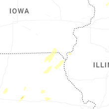
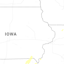
Iowa
| Local Time | Report Details |
|---|---|
| 5:51 PM CDT | Train derailed near new boston. second of two separate trains derailed in area. 30 cars derailed. time estimated from radar dat in lee county IA, 12.9 miles NE of Kahoka, MO |
| 5:52 PM CDT | Train derailed near new boston. one of two separate train derailed in area. time estimated from radar dat in lee county IA, 15 miles NE of Kahoka, MO |
| 6:05 PM CDT | Widespread tree damage throughout all of fort madison from 53rd street to 6th street. trees down on houses... trees on roads. time estimated from radar dat in lee county IA, 24.6 miles NE of Kahoka, MO |
| 6:07 PM CDT | Numerous trees down at rodeo park. time estimated from radar informatio in lee county IA, 26.3 miles NE of Kahoka, MO |
| 6:22 PM CDT | Farm shed destroyed. time estimated from radar dat in louisa county IA, 53.9 miles NNE of Kahoka, MO |
| 6:25 PM CDT | Storm damage reported in des moines county IA, 40.1 miles NE of Kahoka, MO |
| 6:30 PM CDT | Storm damage reported in henry county IA, 38.7 miles NNE of Kahoka, MO |
| 6:46 PM CDT | Trees down in muscatine. time estimated from radar dat in muscatine county IA, 49 miles SE of Cedar Rapids, IA |
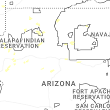
New Mexico
| Local Time | Report Details |
|---|---|
| 5:20 PM MDT | Quarter sized hail reported near Farmington, NM, 4.7 miles NE of Farmington, NM |
Connect with Interactive Hail Maps