

Hail Map for Saturday, June 8, 2019

Number of Impacted Households on 6/8/2019
0
Impacted by 1" or Larger Hail
0
Impacted by 1.75" or Larger Hail
0
Impacted by 2.5" or Larger Hail
Square Miles of Populated Area Impacted on 6/8/2019
0
Impacted by 1" or Larger Hail
0
Impacted by 1.75" or Larger Hail
0
Impacted by 2.5" or Larger Hail

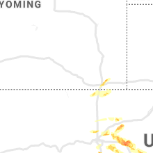


Cities Most Affected by Hail Storms of 6/8/2019
| Hail Size | Demographics of Zip Codes Affected | ||||||
|---|---|---|---|---|---|---|---|
| City | Count | Average | Largest | Pop Density | House Value | Income | Age |
| Brewster, KS | 3 | 1.92 | 2.00 | 1 | $42k | $36.6k | 43.3 |
| Edson, KS | 2 | 2.25 | 2.50 | 1 | $84k | $30.4k | 48.7 |
| Castle Rock, CO | 2 | 2.13 | 2.50 | 453 | $112k | $38.4k | 34.6 |
| Goodland, KS | 2 | 1.88 | 2.00 | 9 | $65k | $33.1k | 41.5 |
| Bird City, KS | 1 | 2.00 | 2.00 | 1 | $43k | $27.5k | 46.6 |
| Cheyenne, WY | 1 | 1.75 | 1.75 | 100 | $82k | $31.0k | 32.6 |
| North Platte, NE | 1 | 1.75 | 1.75 | 50 | $79k | $36.3k | 38.7 |
| Simla, CO | 1 | 1.75 | 1.75 | 3 | $86k | $32.2k | 39.0 |
Hail and Wind Damage Spotted on 6/8/2019
Filter by Report Type:Hail ReportsWind Reports
States Impacted
South Carolina, North Dakota, Minnesota, Nebraska, Wyoming, Kansas, Florida, Colorado, GeorgiaSouth Carolina
| Local Time | Report Details |
|---|---|
| 2:12 PM EDT | Sc highway patrol reported a tree down. time estimated by rada in jasper county SC, 41.5 miles N of Savannah, GA |
| 3:50 PM EDT | Schp reported trees down on roadway near joneswire road and martin neese road in lexington county. time approximated by rada in lexington county SC, 51.7 miles ENE of Augusta, GA |
| 8:25 PM EDT | Tree down near the intersection of calf pen bay road and firetower road. time estimated by rada in jasper county SC, 34.4 miles N of Savannah, GA |
North Dakota
| Local Time | Report Details |
|---|---|
| 1:30 PM CDT | Several large spruce and cottonwood trees were blown down in farmstead shelterbelts along the cass and richland county line. photos posted via social medi in richland county ND, 26.6 miles SW of Fargo, ND |
| 1:38 PM CDT | Large poplar tree branches broken down in shelter belts between mapleton and west fargo. video posted via social medi in cass county ND, 7.7 miles WNW of Fargo, ND |
| 2:00 PM CDT | A towed camper was blown over on interstate 29 neat 13th ave south exit. also privacy fencing was blown down acorss portions of south fargo... and some shingles were bl in cass county ND, 3.4 miles WSW of Fargo, ND |
| 2:08 PM CDT | Peak wind of 65 knots measured at the fargo /kfar/ airpor in cass county ND, 2.8 miles NW of Fargo, ND |
Minnesota
| Local Time | Report Details |
|---|---|
| 2:27 PM CDT | Spotter also reported trees uprooted and power outage in and near glyndo in clay county MN, 8.6 miles E of Fargo, ND |
| 2:30 PM CDT | Quarter sized hail reported near , , 50 miles SSW of Roseau, MN, wind driven hail broke the yard light. |
| 2:56 PM CDT | Peak wind measured by the ndawn sensor near ad in norman county MN, 32.6 miles NNE of Fargo, ND |
| 3:00 PM CDT | Siding was torn off a house. report and photo posted via social medi in norman county MN, 32 miles NNE of Fargo, ND |
| 3:05 PM CDT | Peak wind measured at the mndot rwis near on hwy 89 near gatzk in marshall county MN, 29.4 miles S of Roseau, MN |
| 3:08 PM CDT | Quarter sized hail reported near Gatzke, MN, 23.8 miles S of Roseau, MN, marble to quarter size hail. |
| 3:15 PM CDT | Tree uproote in clay county MN, 14.3 miles ENE of Fargo, ND |
| 3:15 PM CDT | Tree uproote in clay county MN, 14.5 miles ENE of Fargo, ND |
| 3:20 PM CDT | Tree uproote in clay county MN, 14.3 miles ENE of Fargo, ND |
| 3:20 PM CDT | Half Dollar sized hail reported near Wannaska, MN, 15.7 miles S of Roseau, MN |
| 3:40 PM CDT | A gustnado developed on two convergent thunderstorm outflow boundaries and slowly moved across a field. a persistent rotating dust plume was evident on vide in mahnomen county MN, 47.8 miles NE of Fargo, ND |
| 3:40 PM CDT | A gustnado developed on two convergent thunderstorm outflow boundaries and slowly moved across a field. a persistent rotating dust plume was evident on video posted via in mahnomen county MN, 47.8 miles NE of Fargo, ND |
| 4:00 PM CDT | Several trees were snapped or uprooted in a farmstea in polk county MN, 44.8 miles NW of Bemidji, MN |
Nebraska
| Local Time | Report Details |
|---|---|
| 3:40 PM CDT | Quarter sized hail reported near Tryon, NE, 32.7 miles NNW of North Platte, NE |
| 4:31 PM CDT | Quarter sized hail reported near Tryon, NE, 23.2 miles N of North Platte, NE |
| 4:45 PM CDT | Ping Pong Ball sized hail reported near North Platte, NE, 17.6 miles NNW of North Platte, NE |
| 5:25 PM CDT | Storm damage reported in lincoln county NE, 3.7 miles N of North Platte, NE |
| 5:26 PM CDT | Quarter sized hail reported near Stapleton, NE, 14.4 miles NNE of North Platte, NE |
| 5:27 PM CDT | Quarter sized hail reported near North Platte, NE, 11.7 miles NE of North Platte, NE |
| 5:30 PM CDT | Quarter sized hail reported near North Platte, NE, 4.6 miles W of North Platte, NE, bailey yards |
| 5:35 PM CDT | Half Dollar sized hail reported near North Platte, NE, 0.6 miles SW of North Platte, NE, corrects previous hail report from north platte. |
| 5:37 PM CDT | Quarter sized hail reported near North Platte, NE, 0.6 miles SW of North Platte, NE |
| 5:48 PM CDT | Golf Ball sized hail reported near North Platte, NE, 2.5 miles S of North Platte, NE |
| 5:50 PM CDT | Half Dollar sized hail reported near Palisade, NE, 57.2 miles SSW of North Platte, NE |
| 5:54 PM CDT | Half Dollar sized hail reported near North Platte, NE, 2.5 miles S of North Platte, NE |
| 6:20 PM CDT | Quarter sized hail reported near Brady, NE, 17.7 miles ESE of North Platte, NE |
| 7:54 PM CDT | Quarter sized hail reported near Merna, NE, 60.4 miles ENE of North Platte, NE |
| 8:09 PM CDT | Report of power pole/power line damage in town. power line lying across the hwy 34/283 junction. tree limbs of 6-8 inches downed. this spotter measured a 73 mph wind on in furnas county NE, 72.8 miles SE of North Platte, NE |
| 8:11 PM CDT | Wind measured on a hand held anemomete in gosper county NE, 70.1 miles SE of North Platte, NE |
| 8:14 PM CDT | Measured on handheld anemomete in gosper county NE, 67.5 miles SE of North Platte, NE |
| 8:30 PM CDT | Storm damage reported in phelps county NE, 74.9 miles WSW of Grand Island, NE |
| 8:36 PM CDT | Storm damage reported in furnas county NE, 81.5 miles WSW of Grand Island, NE |
| 8:39 PM CDT | Storm damage reported in phelps county NE, 70.7 miles WSW of Grand Island, NE |
| 8:40 PM CDT | Storm damage reported in phelps county NE, 68.5 miles WSW of Grand Island, NE |
| 8:43 PM CDT | Storm damage reported in phelps county NE, 66 miles WSW of Grand Island, NE |
| 8:45 PM CDT | Wind gusts estimated to be at least 70 mp in phelps county NE, 66.9 miles WSW of Grand Island, NE |
| 8:46 PM CDT | Storm damage reported in phelps county NE, 68.9 miles WSW of Grand Island, NE |
| 8:47 PM CDT | Storm damage reported in harlan county NE, 78.7 miles WSW of Grand Island, NE |
| 8:50 PM CDT | Storm damage reported in phelps county NE, 64.1 miles WSW of Grand Island, NE |
| 8:55 PM CDT | Power was lost in part of town... sparks were reported at a substation. 4 power poles were damaged near 18th ave. and lincoln st. a large tree was downed at the cemeter in phelps county NE, 64.1 miles WSW of Grand Island, NE |
| 8:57 PM CDT | Storm damage reported in phelps county NE, 61.9 miles WSW of Grand Island, NE |
| 10:30 PM CDT | Estimated 55-60 mph winds. winds were strong for about 5-7 minute in adams county NE, 32.8 miles S of Grand Island, NE |
Wyoming
| Local Time | Report Details |
|---|---|
| 3:13 PM MDT | Quarter sized hail reported near Cheyenne, WY, 43.2 miles ESE of Laramie, WY |
| 3:15 PM MDT | Quarter sized hail reported near Cheyenne, WY, 44.3 miles ESE of Laramie, WY, hail measured between the size of peas to quarters at menards in cheyenne. |
| 3:18 PM MDT | Quarter sized hail reported near Cheyenne, WY, 44.3 miles ESE of Laramie, WY, started as quarter sized... then down to pea sized hail by end of event. |
| 3:20 PM MDT | Golf Ball sized hail reported near Cheyenne, WY, 43.7 miles ESE of Laramie, WY, ema reports quarters to golfballs. |
| 3:22 PM MDT | Quarter sized hail reported near Cheyenne, WY, 45.2 miles ESE of Laramie, WY, east pershing and college. |
| 3:22 PM MDT | Ping Pong Ball sized hail reported near Cheyenne, WY, 44.5 miles ESE of Laramie, WY, sonic at dell range |
| 3:24 PM MDT | Quarter sized hail reported near Cheyenne, WY, 44.3 miles ESE of Laramie, WY |
| 3:25 PM MDT | Ping Pong Ball sized hail reported near Cheyenne, WY, 43.1 miles ESE of Laramie, WY, former spotter from colorado observed 1.5 inch hail |
| 3:35 PM MDT | Half Dollar sized hail reported near Cheyenne, WY, 43.1 miles ESE of Laramie, WY, hail measured over the size of a quarter 3 blocks se of downtown hospital |
Kansas
| Local Time | Report Details |
|---|---|
| 4:15 PM CDT | Hen Egg sized hail reported near Bird City, KS, 42.7 miles NW of Colby, KS, report via facebook of 2 inch hail. |
| 4:28 PM CDT | Quarter sized hail reported near Brewster, KS, 18 miles W of Colby, KS |
| 4:40 PM CDT | Quarter sized hail reported near Saint Francis, KS, 46.9 miles WNW of Colby, KS, delayed report via facebook of pea to quarter size hail. hail lasted about ten minutes. |
| 4:55 PM CDT | Half Dollar sized hail reported near Saint Francis, KS, 48.6 miles WNW of Colby, KS, hail lasted 15 minutes with the largest hailstones around half dollar size. |
| 5:00 PM CDT | Half Dollar sized hail reported near Saint Francis, KS, 48.6 miles WNW of Colby, KS, hail is ongoing. also spotter says tornado has dissipated. |
| 4:15 PM MDT | Hen Egg sized hail reported near Goodland, KS, 30.6 miles W of Colby, KS |
| 5:51 PM CDT | Quarter sized hail reported near Atwood, KS, 33.6 miles N of Colby, KS |
| 5:02 PM MDT | Hen Egg sized hail reported near Edson, KS, 26.8 miles W of Colby, KS |
| 6:30 PM CDT | Ping Pong Ball sized hail reported near Brewster, KS, 17.5 miles W of Colby, KS |
| 5:35 PM MDT | Quarter sized hail reported near Goodland, KS, 34.5 miles W of Colby, KS |
| 5:37 PM MDT | Ping Pong Ball sized hail reported near Goodland, KS, 35.6 miles W of Colby, KS, trained spotter reported hail size of 1.61 inches (41 mm). |
| 7:10 PM MDT | Mesonet report of 60 mph wind gus in sherman county KS, 29.1 miles W of Colby, KS |
| 7:10 PM MDT | Tennis Ball sized hail reported near Edson, KS, 27.3 miles WSW of Colby, KS, this is on road 29 south of edson. |
| 8:30 PM CDT | Hen Egg sized hail reported near Brewster, KS, 17.6 miles W of Colby, KS, corrects previous hail report from brewster. report from near the brewster exit on i70. corrected the previous report to correct the time of the report. |
| 7:30 PM MDT | Golf Ball sized hail reported near Goodland, KS, 37.1 miles W of Colby, KS |
| 8:47 PM CDT | Quarter sized hail reported near Brewster, KS, 21.7 miles SW of Colby, KS |
| 8:51 PM CDT | Hen Egg sized hail reported near Brewster, KS, 17.6 miles W of Colby, KS, report from near the brewster exit on i70. |
| 8:55 PM CDT | Half Dollar sized hail reported near Winona, KS, 20.6 miles SSW of Colby, KS |
| 9:19 PM CDT | Ping Pong Ball sized hail reported near Winona, KS, 25.5 miles SSW of Colby, KS |
| 9:30 PM CDT | Golf Ball sized hail reported near Brewster, KS, 22.2 miles WSW of Colby, KS, delayed report via social media. |
| 9:30 PM CDT | Quarter sized hail reported near Brewster, KS, 21.7 miles SW of Colby, KS, delayed report via facebook. |
| 9:45 PM CDT | Ping Pong Ball sized hail reported near Brewster, KS, 21.7 miles SW of Colby, KS, delayed report via social media. |
| 9:55 PM CDT | Winona has lost power. unknown whether from straightline winds or tornad in logan county KS, 25.1 miles SSW of Colby, KS |
| 10:45 PM CDT | Ping Pong Ball sized hail reported near Winona, KS, 25.5 miles SSW of Colby, KS |
| 11:29 PM CDT | Storm damage reported in sheridan county KS, 32 miles E of Colby, KS |
| 12:09 AM CDT | Storm damage reported in gove county KS, 48.7 miles ESE of Colby, KS |
| 12:20 AM CDT | Mesonet station dw2812 scott cit in scott county KS, 35.4 miles NNE of Garden City, KS |
| 12:40 AM CDT | Mesonet station k5wky 1 ssw wakeene in trego county KS, 31 miles WNW of Hays, KS |
| 2:06 AM CDT | Asos station krsl russell municipal airpor in russell county KS, 27.6 miles E of Hays, KS |
| 2:10 AM CDT | Storm damage reported in barton county KS, 38.9 miles SE of Hays, KS |
| 4:10 AM CDT | Storm damage reported in sedgwick county KS, 7.2 miles WNW of Wichita, KS |
Florida
| Local Time | Report Details |
|---|---|
| 5:25 PM EDT | Several trees down. damage to barn roof which fell onto two vehicle in hardee county FL, 55.8 miles E of Bradenton, FL |
Colorado
| Local Time | Report Details |
|---|---|
| 3:39 PM MDT | Quarter sized hail reported near Idalia, CO, 42.6 miles SE of Yuma, CO, public reported 1 hail over hwy 385. time estimated based on radar. |
| 3:55 PM MDT | Half Dollar sized hail reported near Broomfield, CO, 18.1 miles N of Denver, CO |
| 3:58 PM MDT | Quarter sized hail reported near Louisville, CO, 17.7 miles NNW of Denver, CO |
| 4:25 PM MDT | Quarter sized hail reported near Broomfield, CO, 13.9 miles N of Denver, CO |
| 4:55 PM MDT | Quarter sized hail reported near Brighton, CO, 15.7 miles NNE of Denver, CO |
| 5:05 PM MDT | Quarter sized hail reported near Commerce City, CO, 16.6 miles NE of Denver, CO |
| 5:11 PM MDT | Ping Pong Ball sized hail reported near Erie, CO, 20.2 miles N of Denver, CO |
| 5:15 PM MDT | Quarter sized hail reported near Brighton, CO, 22.5 miles NE of Denver, CO |
| 5:45 PM MDT | Quarter sized hail reported near Castle Rock, CO, 25.8 miles SSE of Denver, CO |
| 6:00 PM MDT | Ping Pong Ball sized hail reported near Castle Rock, CO, 26.7 miles SSE of Denver, CO |
| 6:02 PM MDT | Quarter sized hail reported near Franktown, CO, 27.4 miles SSE of Denver, CO |
| 6:06 PM MDT | Ping Pong Ball sized hail reported near Byers, CO, 41.2 miles E of Denver, CO |
| 6:17 PM MDT | Tennis Ball sized hail reported near Castle Rock, CO, 23.7 miles SSE of Denver, CO |
| 6:29 PM MDT | Ping Pong Ball sized hail reported near Bennett, CO, 36.8 miles ESE of Denver, CO |
| 6:30 PM MDT | Storm damage reported in elbert county CO, 46.2 miles ESE of Denver, CO |
| 6:49 PM MDT | Golf Ball sized hail reported near Castle Rock, CO, 25.3 miles SSE of Denver, CO |
| 7:09 PM MDT | Golf Ball sized hail reported near Simla, CO, 64 miles SE of Denver, CO |
| 7:56 PM MDT | Quarter sized hail reported near Vernon, CO, 24 miles SE of Yuma, CO |
| 8:43 PM MDT | Storm damage reported in cheyenne county CO, 93.1 miles S of Yuma, CO |
| 8:52 PM MDT | Storm damage reported in cheyenne county CO, 90 miles WSW of Colby, KS |
Georgia
| Local Time | Report Details |
|---|---|
| 6:33 PM EDT | A large tree was reported down at the intersection of highway 129 and sapptown road. time was estimated by rada in evans county GA, 53 miles W of Savannah, GA |
| 7:00 PM EDT | Multiple trees reported down across the county. location details not yet known. broad time estimate based on rada in liberty county GA, 27.8 miles SW of Savannah, GA |
| 7:03 PM EDT | Metal bleachers were blown over in strong winds. time estimated by radar. several trees down across the base. location details not yet known. time estimated by rada in liberty county GA, 33.8 miles WSW of Savannah, GA |
| 7:42 PM EDT | Tree down at 119 south and honey ridge road. time estimated by rada in effingham county GA, 24.9 miles NW of Savannah, GA |
Connect with Interactive Hail Maps