

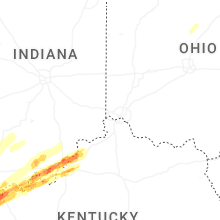
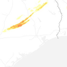
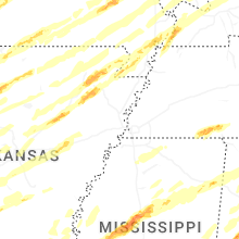
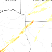
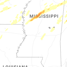
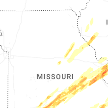
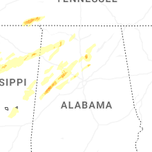
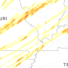
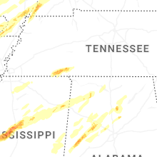
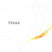
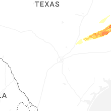
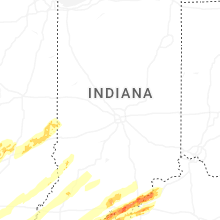
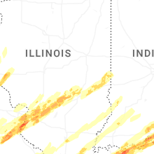
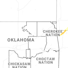
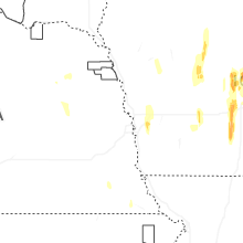
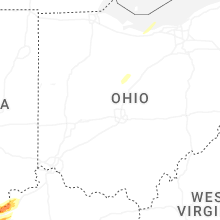
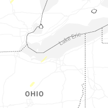
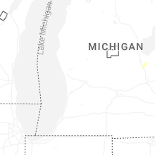
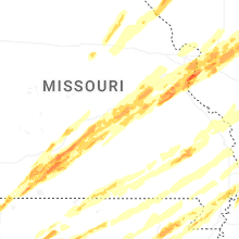
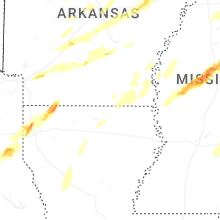
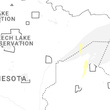
Hail Map for Friday, March 14, 2025

Number of Impacted Households on 3/14/2025
0
Impacted by 1" or Larger Hail
0
Impacted by 1.75" or Larger Hail
0
Impacted by 2.5" or Larger Hail
Square Miles of Populated Area Impacted on 3/14/2025
0
Impacted by 1" or Larger Hail
0
Impacted by 1.75" or Larger Hail
0
Impacted by 2.5" or Larger Hail


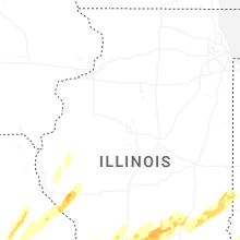
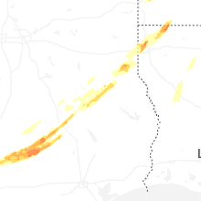
Cities Most Affected by Hail Storms of 3/14/2025
| Hail Size | Demographics of Zip Codes Affected | ||||||
|---|---|---|---|---|---|---|---|
| City | Count | Average | Largest | Pop Density | House Value | Income | Age |
| Ozark, MO | 3 | 1.75 | 1.75 | 300 | $99k | $38.6k | 34.6 |
| Sellersburg, IN | 2 | 2.00 | 2.00 | 682 | $107k | $46.0k | 37.3 |
| House Springs, MO | 2 | 1.75 | 1.75 | 312 | $98k | $47.0k | 37.4 |
| Highlandville, MO | 1 | 2.75 | 2.75 | 51 | $95k | $34.3k | 43.3 |
| Saint Louis, MO | 1 | 2.00 | 2.00 | 2560 | $143k | $60.6k | 42.4 |
| Sullivan, MO | 1 | 2.00 | 2.00 | 53 | $78k | $36.0k | 38.8 |
| Fenton, MO | 1 | 1.75 | 1.75 | 1787 | $130k | $55.4k | 38.6 |
| Owensboro, KY | 1 | 1.75 | 1.75 | 250 | $80k | $34.7k | 38.7 |
| Catawissa, MO | 1 | 1.75 | 1.75 | 127 | $100k | $47.0k | 41.7 |
| Ledbetter, KY | 1 | 1.75 | 1.75 | 134 | $62k | $35.9k | 40.7 |
| Harrisburg, IL | 1 | 1.75 | 1.75 | 95 | $52k | $29.6k | 41.2 |
| Bragg City, MO | 1 | 1.75 | 1.75 | 8 | $41k | $25.8k | 47.0 |
| Union, MO | 1 | 1.75 | 1.75 | 235 | $96k | $41.1k | 35.8 |
| Salem, MO | 1 | 1.75 | 1.75 | 21 | $63k | $27.0k | 42.8 |
| Princeton, IN | 1 | 1.75 | 1.75 | 155 | $67k | $33.7k | 39.2 |
| Jasper, AR | 1 | 1.75 | 1.75 | 14 | $54k | $22.5k | 47.8 |
| New Albany, IN | 1 | 1.75 | 1.75 | 1112 | $93k | $38.1k | 38.0 |
| Vandalia, IL | 1 | 1.75 | 1.75 | 63 | $65k | $32.5k | 38.6 |
| Corydon, IN | 1 | 1.75 | 1.75 | 101 | $99k | $42.4k | 39.7 |
| Reeds Spring, MO | 1 | 1.75 | 1.75 | 97 | $107k | $29.5k | 47.7 |
| Pittsfield, IL | 1 | 1.75 | 1.75 | 37 | $68k | $31.3k | 43.0 |
Hail and Wind Damage Spotted on 3/14/2025
Filter by Report Type:Hail ReportsWind Reports
States Impacted
Wisconsin, Illinois, Kansas, Missouri, Nebraska, Iowa, Arkansas, Minnesota, South Dakota, Texas, Mississippi, Indiana, Kentucky, Alabama, Tennessee, Louisiana, OhioWisconsin
| Local Time | Report Details |
|---|---|
| 8:33 AM CDT | Quarter sized hail reported near Ashland, WI, 52.5 miles ESE of Duluth, MN |
| 8:40 AM CDT | Quarter sized hail reported near Washburn, WI, 55 miles E of Duluth, MN |
| 8:44 AM CDT | Quarter sized hail reported near Ashland, WI, 58 miles ESE of Duluth, MN, report from mping. |
| 9:14 AM CDT | Quarter sized hail reported near Washburn, WI, 57.6 miles E of Duluth, MN, report from mping: quarter (1.00 in.). |
| 10:10 PM CDT | Storm damage reported in grant county WI, 60 miles WSW of Madison, WI |
| 10:13 PM CDT | Wind gusts in the mid to upper 60s measured on home weather statio in lafayette county WI, 61.7 miles SW of Madison, WI |
| 10:41 PM CDT | Reports of uprooted trees and power issues from fennimore to boscobel to muscod in grant county WI, 55 miles SE of La Crosse, WI |
| 10:46 PM CDT | Storm damage reported in iowa county WI, 37.8 miles W of Madison, WI |
| 10:51 PM CDT | Mesonet station ap090 madiso in iowa county WI, 37.8 miles W of Madison, WI |
| 11:25 PM CDT | Trees down in town of unio in rock county WI, 17.3 miles SSE of Madison, WI |
| 11:27 PM CDT | Trees down with power lines dow in rock county WI, 33.5 miles S of Madison, WI |
| 11:39 PM CDT | Tree damage on the southwest side of janesvill in rock county WI, 33.2 miles SSE of Madison, WI |
| 11:42 PM CDT | Roof reported blown of in rock county WI, 32.9 miles SE of Madison, WI |
| 11:45 PM CDT | Multiple trees on trailer in rock county WI, 40.8 miles SSE of Madison, WI |
| 11:45 PM CDT | Tree came through a roof of a hom in dane county WI, 20.9 miles SE of Madison, WI |
| 11:50 PM CDT | Mesonet station wi087 i-39 90 at church r in dane county WI, 12.5 miles ESE of Madison, WI |
| 11:50 PM CDT | Mesonet station wi088 i-39 90 at sth 59 newvill in rock county WI, 24.2 miles SE of Madison, WI |
| 11:50 PM CDT | Mesonet station wi089 i-39 90 at sth 2 in rock county WI, 31.1 miles SE of Madison, WI |
| 12:00 AM CDT | Mesonet station wiwlh walwort in walworth county WI, 53.3 miles SE of Madison, WI |
| 12:06 AM CDT | Several reports of tree and powerline damag in jefferson county WI, 21.4 miles ENE of Madison, WI |
| 12:15 AM CDT | Numerous trees down between sullivan and oconomowo in jefferson county WI, 41.9 miles E of Madison, WI |
| 12:22 AM CDT | Mesonet station ew4463 sun prairi in dane county WI, 20 miles WNW of Madison, WI |
| 12:25 AM CDT | Storm damage reported in waukesha county WI, 45.5 miles E of Madison, WI |
| 12:29 AM CDT | Mesonet station wi090 waukesha co i-94 wb at sth 6 in waukesha county WI, 46.4 miles E of Madison, WI |
| 12:33 AM CDT | Large tree dow in dodge county WI, 45.8 miles NE of Madison, WI |
| 12:35 AM CDT | Several fences blown down between beaver dam and horico in dodge county WI, 40.9 miles NE of Madison, WI |
| 12:39 AM CDT | Mesonet station wi073 i-43 sb at sth 8 in waukesha county WI, 56.2 miles ESE of Madison, WI |
| 12:40 AM CDT | 50 kt gust measured at the dodge county airport in junea in dodge county WI, 42.5 miles NE of Madison, WI |
| 12:57 AM CDT | Milwaukee asos measured 62 mph/54 knot in milwaukee county WI, 74.8 miles N of Chicago, IL |
Illinois
| Local Time | Report Details |
|---|---|
| 11:40 AM CDT | Storm damage reported in boone county IL, 59 miles SSE of Madison, WI |
| 11:58 AM CDT | Storm damage reported in dupage county IL, 30.3 miles W of Chicago, IL |
| 7:47 PM CDT | Large limbs down in quinc in adams county IL, 37.5 miles SSE of Kahoka, MO |
| 8:31 PM CDT | Storm damage reported in mcdonough county IL, 48.4 miles E of Kahoka, MO |
| 8:40 PM CDT | Corrects time of occurrence for previous tstm wnd gst report from 2 e bald bluff. estimated storm outflow gus in henderson county IL, 63.2 miles NE of Kahoka, MO |
| 8:45 PM CDT | Golf Ball sized hail reported near Pittsfield, IL, 74.4 miles SE of Kahoka, MO, report from mping: golf ball (1.75 in.). |
| 8:47 PM CDT | Quarter sized hail reported near Pittsfield, IL, 74.4 miles SE of Kahoka, MO, report from mping: quarter (1.00 in.). |
| 8:55 PM CDT | Public report of 60 to 70 mph wind gusts. some small branches reported dow in mcdonough county IL, 55.5 miles WSW of Peoria, IL |
| 8:56 PM CDT | Estimated storm outflow gus in henderson county IL, 63.2 miles NE of Kahoka, MO |
| 9:05 PM CDT | Sheriff department reported multiple powerlines down throughout the count in mcdonough county IL, 54.9 miles E of Kahoka, MO |
| 9:15 PM CDT | Reported at gb in knox county IL, 47.3 miles WNW of Peoria, IL |
| 9:40 PM CDT | Metal carport blown down. time estimated from rada in fulton county IL, 25.2 miles WSW of Peoria, IL |
| 9:41 PM CDT | Storm damage reported in henry county IL, 52.8 miles NW of Peoria, IL |
| 9:46 PM CDT | Overturned semi on the illinois side of the jb bridg in monroe county IL, 10.2 miles SSW of Saint Louis, MO |
| 9:52 PM CDT | St. clair county em reported a tree fell on a house on melvin drive... injuring a 9-year old in cahokia heights. time estimated from rada in st. clair county IL, 5.6 miles SSE of Saint Louis, MO |
| 10:00 PM CDT | Restaurant sign blown over. time estimated from rada in peoria county IL, 11.1 miles W of Peoria, IL |
| 10:03 PM CDT | Ping Pong Ball sized hail reported near Collinsville, IL, 11.4 miles ENE of Saint Louis, MO |
| 10:05 PM CDT | Quarter sized hail reported near Troy, IL, 18.9 miles ENE of Saint Louis, MO |
| 10:06 PM CDT | Quarter sized hail reported near O Fallon, IL, 15.9 miles E of Saint Louis, MO |
| 10:06 PM CDT | Quarter sized hail reported near Glen Carbon, IL, 15.9 miles ENE of Saint Louis, MO |
| 10:07 PM CDT | Trees dow in peoria county IL, 15.1 miles WNW of Peoria, IL |
| 10:07 PM CDT | Half Dollar sized hail reported near Columbia, IL, 13 miles S of Saint Louis, MO, corrects previous hail report from 2 ese columbia. columbia pd reported hail between quarter and golf ball size. |
| 10:08 PM CDT | Quarter sized hail reported near Troy, IL, 18.2 miles ENE of Saint Louis, MO |
| 10:08 PM CDT | Half Dollar sized hail reported near Valmeyer, IL, 23 miles SSW of Saint Louis, MO, report from mping: half dollar (1.25 in.). |
| 10:08 PM CDT | Tree down. time estimated from rada in tazewell county IL, 8.7 miles SSW of Peoria, IL |
| 10:10 PM CDT | 60 to 70 mph winds estimated from new berlin to loam in sangamon county IL, 68.5 miles SSW of Peoria, IL |
| 10:10 PM CDT | Ping Pong Ball sized hail reported near Columbia, IL, 10.9 miles S of Saint Louis, MO, report from mping: ping pong ball (1.50 in.). |
| 10:12 PM CDT | Half Dollar sized hail reported near Columbia, IL, 13 miles S of Saint Louis, MO, columbia pd reported hail between quarter and golf ball size. |
| 10:22 PM CDT | Storm damage reported in peoria county IL, 16.5 miles NNE of Peoria, IL |
| 10:25 PM CDT | Quarter sized hail reported near O Fallon, IL, 15.3 miles E of Saint Louis, MO |
| 10:27 PM CDT | Quarter sized hail reported near O Fallon, IL, 16.2 miles ESE of Saint Louis, MO, report from mping: quarter (1.00 in.). |
| 10:27 PM CDT | Quarter sized hail reported near Millstadt, IL, 9.8 miles SSE of Saint Louis, MO, report from mping: quarter (1.00 in.). |
| 10:28 PM CDT | Quarter sized hail reported near O Fallon, IL, 17.4 miles ESE of Saint Louis, MO, report from mping: quarter (1.00 in.). |
| 10:28 PM CDT | Quarter sized hail reported near O Fallon, IL, 15.1 miles E of Saint Louis, MO, report from mping: quarter (1.00 in.). |
| 10:28 PM CDT | Measured from personal weather station. time estimate in whiteside county IL, 65.6 miles N of Peoria, IL |
| 10:30 PM CDT | Quarter sized hail reported near O Fallon, IL, 15.9 miles E of Saint Louis, MO |
| 10:31 PM CDT | Also reported quarter size hail with 1.1 inches of rai in st. clair county IL, 17.1 miles E of Saint Louis, MO |
| 10:33 PM CDT | Quarter sized hail reported near Troy, IL, 18.7 miles ENE of Saint Louis, MO, from madison county il em. |
| 10:38 PM CDT | Pritchard road between perry and harter roads closed due to downed power line in de kalb county IL, 51 miles W of Chicago, IL |
| 10:39 PM CDT | Quarter sized hail reported near Saint Jacob, IL, 24.1 miles ENE of Saint Louis, MO, dime to quarter size hail. |
| 10:40 PM CDT | Quarter sized hail reported near Highland, IL, 30.5 miles ENE of Saint Louis, MO |
| 10:41 PM CDT | Report of mobile home destroye in st. clair county IL, 20.6 miles E of Saint Louis, MO |
| 10:44 PM CDT | Quarter sized hail reported near Highland, IL, 29.7 miles ENE of Saint Louis, MO, ham operator reporting quarter size hail. |
| 10:45 PM CDT | Quarter sized hail reported near O Fallon, IL, 17.1 miles ESE of Saint Louis, MO |
| 10:47 PM CDT | St. clair county em reported more than 20 places of power lines down in ofallon... mascoutah... and lebano in st. clair county IL, 21.2 miles ESE of Saint Louis, MO |
| 10:50 PM CDT | Storm damage reported in la salle county IL, 55.6 miles NNE of Peoria, IL |
| 10:55 PM CDT | Awos station kvys peru airpor in la salle county IL, 50.8 miles NNE of Peoria, IL |
| 10:57 PM CDT | Damage to a shed and fenc in clinton county IL, 31.9 miles E of Saint Louis, MO |
| 11:00 PM CDT | St. clair county em reported mobile home overturned with residents trapped insid in st. clair county IL, 21.1 miles E of Saint Louis, MO |
| 11:03 PM CDT | Tree on a house with residents trapped. residents have been free in marion county IL, 70.1 miles E of Saint Louis, MO |
| 11:04 PM CDT | Storm damage reported in livingston county IL, 44.6 miles ENE of Peoria, IL |
| 11:05 PM CDT | Storm damage reported in lee county IL, 73.5 miles NNE of Peoria, IL |
| 11:07 PM CDT | Storm damage reported in ogle county IL, 70.1 miles S of Madison, WI |
| 11:07 PM CDT | House collapsed with 2 elderly occupants trappe in st. clair county IL, 17.9 miles E of Saint Louis, MO |
| 11:09 PM CDT | Large tree blocking wolf road near westview roa in st. clair county IL, 20.4 miles SE of Saint Louis, MO |
| 11:10 PM CDT | Storm damage reported in ogle county IL, 64.9 miles S of Madison, WI |
| 11:10 PM CDT | Storm damage reported in la salle county IL, 63.2 miles NE of Peoria, IL |
| 11:10 PM CDT | 4 foot diameter pine tree uproote in clinton county IL, 31.9 miles E of Saint Louis, MO |
| 11:18 PM CDT | Irvington grade school has a light pole broken at ground leve in washington county IL, 57.8 miles ESE of Saint Louis, MO |
| 11:20 PM CDT | Wtvo/wqr in winnebago county IL, 55.2 miles SSE of Madison, WI |
| 11:22 PM CDT | Golf Ball sized hail reported near Vandalia, IL, 52.5 miles SW of Mattoon, IL |
| 11:23 PM CDT | Asos station krfd rockford airpor in winnebago county IL, 62 miles SSE of Madison, WI |
| 11:25 PM CDT | Storm damage reported in de kalb county IL, 55.7 miles W of Chicago, IL |
| 11:25 PM CDT | Half Dollar sized hail reported near Altamont, IL, 35.3 miles SW of Mattoon, IL |
| 11:28 PM CDT | Storm damage reported in winnebago county IL, 52.9 miles S of Madison, WI |
| 11:31 PM CDT | Storm damage reported in de kalb county IL, 61.3 miles WSW of Chicago, IL |
| 11:32 PM CDT | Storm damage reported in de kalb county IL, 53.2 miles W of Chicago, IL |
| 11:35 PM CDT | Report shared via social media of power lines downed on i-90 near south beloit. time estimated by rada in winnebago county IL, 45.4 miles SSE of Madison, WI |
| 11:35 PM CDT | Tree down on power lines with a minor fir in marion county IL, 65.8 miles SSW of Mattoon, IL |
| 11:37 PM CDT | Tree down across road on power line in kane county IL, 49.9 miles W of Chicago, IL |
| 11:37 PM CDT | Report of trees downed and building damag in kane county IL, 50 miles W of Chicago, IL |
| 11:37 PM CDT | Trees reported down on road in many locations along beith roa in kane county IL, 48.4 miles W of Chicago, IL |
| 11:38 PM CDT | Corrects previous tstm wnd dmg report from 4 ssw maple park. pritchard road between perry and harter roads closed due to downed power line in de kalb county IL, 51 miles W of Chicago, IL |
| 11:40 PM CDT | Tree in road... 20-30 feet long... 3-4 feet diamete in kane county IL, 42.9 miles W of Chicago, IL |
| 11:41 PM CDT | Building damage... wires dow in kane county IL, 50.5 miles WNW of Chicago, IL |
| 11:42 PM CDT | Power line and tree limbs dow in kane county IL, 51.2 miles WNW of Chicago, IL |
| 11:44 PM CDT | Awos station karr 2 wnw sugar grov in kane county IL, 44.5 miles W of Chicago, IL |
| 11:44 PM CDT | Centralia esda reporting multiple power lines dow in marion county IL, 58.3 miles E of Saint Louis, MO |
| 11:44 PM CDT | Tree debris on roadwa in kane county IL, 46.9 miles WNW of Chicago, IL |
| 11:49 PM CDT | Tree down blocking roa in kane county IL, 42.2 miles WNW of Chicago, IL |
| 11:49 PM CDT | Multiple areas with power lines downed across west side of auror in kane county IL, 37.9 miles WSW of Chicago, IL |
| 11:51 PM CDT | Fayette county ema reporting multiple lines down in vandali in fayette county IL, 52.5 miles SW of Mattoon, IL |
| 11:56 PM CDT | Asos station kdpa west chicago - dupage arp in dupage county IL, 31.9 miles W of Chicago, IL |
| 12:00 AM CDT | Trained spotter reports 6 power poles down at sr 173 and price rd in hebron. time estimated by rada in mchenry county IL, 57.9 miles NW of Chicago, IL |
| 12:00 AM CDT | Report from social media. porch and portion of roof torn off of hom in cumberland county IL, 11.8 miles SSW of Mattoon, IL |
| 12:02 AM CDT | Semis blown over on i-5 in cumberland county IL, 10.8 miles SSW of Mattoon, IL |
| 12:04 AM CDT | Trained spotter reports part of a roof was blown off of a pole barn along button rd northeast of hebron. time estimated by rada in mchenry county IL, 57.5 miles NW of Chicago, IL |
| 12:09 AM CDT | Report of house destroye in randolph county IL, 42.1 miles NNW of Cape Girardeau, MO |
| 12:12 AM CDT | Power poles reported down on highway 154. time estimated from rada in perry county IL, 52.4 miles SE of Saint Louis, MO |
| 12:15 AM CDT | Fire department responding to blown transformers... some on fire across tow in cook county IL, 24.5 miles WNW of Chicago, IL |
| 12:15 AM CDT | Power lines down. time estimated from rada in coles county IL, 5.5 miles SE of Mattoon, IL |
| 12:20 AM CDT | Power poles and lines down. time estimated from rada in coles county IL, 12.1 miles E of Mattoon, IL |
| 12:24 AM CDT | Storm damage reported in lake county IL, 48.2 miles NNW of Chicago, IL |
| 12:31 AM CDT | Power poles broken and powerlines dow in coles county IL, 3.4 miles N of Mattoon, IL |
| 12:32 AM CDT | Reported at cm in champaign county IL, 38.9 miles N of Mattoon, IL |
| 12:58 AM CDT | A few trailers flippe in champaign county IL, 60.2 miles NNE of Mattoon, IL |
| 1:49 AM CDT | Golf Ball sized hail reported near Harrisburg, IL, 56.3 miles WSW of Evansville, IN |
| 2:31 AM CDT | Tree down on house in brookport. line damag in massac county IL, 54.1 miles ESE of Cape Girardeau, MO |
Kansas
| Local Time | Report Details |
|---|---|
| 12:02 PM CDT | 65 mph winds near 251st and springdale rd. also had dime size hai in leavenworth county KS, 32.8 miles WNW of Kansas City, MO |
| 2:24 PM CDT | Private weather sensor. precipitation recorded at time of measuremen in miami county KS, 37.7 miles SSW of Kansas City, MO |
| 2:46 PM CDT | Tree branches broken near 4 inch in diamete in cherokee county KS, 48.8 miles SE of Chanute, KS |
| 2:47 PM CDT | Em relayed trained spotter report of 60 mph measured wind gust in johnson county KS, 22.6 miles WSW of Kansas City, MO |
| 2:51 PM CDT | Asos station kixd olathe new century aircente in johnson county KS, 25.2 miles SW of Kansas City, MO |
| 3:04 PM CDT | Trained spotter relayed measured 67 mph wind gus in wyandotte county KS, 12.5 miles WNW of Kansas City, MO |
| 3:15 PM CDT | Storm damage reported in cherokee county KS, 54.4 miles SE of Chanute, KS |
| 3:16 PM CDT | Measured by personal weather statio in wyandotte county KS, 12.5 miles WNW of Kansas City, MO |
| 3:53 PM CDT | Mesonet station up841 1.9 w monument (upr). lightning was occurring around time of gus in logan county KS, 20.5 miles S of Colby, KS |
| 4:35 PM CDT | Awos station koin oberli in decatur county KS, 40.6 miles NE of Colby, KS |
Missouri
| Local Time | Report Details |
|---|---|
| 3:12 PM CDT | Storm damage reported in mcdonald county MO, 76.5 miles WSW of Springfield, MO |
| 3:13 PM CDT | Propane station canopy blown down. relayed via social media. timing estimated from rada in johnson county MO, 49.5 miles ESE of Kansas City, MO |
| 3:20 PM CDT | Storm damage reported in jasper county MO, 66 miles SE of Chanute, KS |
| 3:35 PM CDT | Public relayed... via social media video... estimated wind gusts 65 to 70 mp in jackson county MO, 9.5 miles ESE of Kansas City, MO |
| 3:35 PM CDT | Local law enforcement reporting trees down in blue springs... including at least 1 reported on vehicl in jackson county MO, 17.3 miles ESE of Kansas City, MO |
| 3:35 PM CDT | Public reported siding torn from a business and estimated winds of 60 mp in jackson county MO, 25.4 miles ESE of Kansas City, MO |
| 3:37 PM CDT | Storm damage reported in jackson county MO, 16.6 miles SE of Kansas City, MO |
| 3:37 PM CDT | Multiple trees down around harrisonville. timing estimated via rada in cass county MO, 33.7 miles SSE of Kansas City, MO |
| 3:45 PM CDT | Measured by stj aso in buchanan county MO, 49.9 miles NNW of Kansas City, MO |
| 3:49 PM CDT | Emergency management reported a downed power line in rural pleasant hill. location estimate in cass county MO, 28.3 miles SE of Kansas City, MO |
| 3:50 PM CDT | Report of a semi blown over along mo-210 via social media relayed by law enforcement. timing estimated via rada in ray county MO, 25.6 miles ENE of Kansas City, MO |
| 3:53 PM CDT | Measured 58 mph wind gust at kst in buchanan county MO, 49 miles NNW of Kansas City, MO |
| 3:53 PM CDT | Tree fallen on house in excelsior springs. timing estimated via rada in clay county MO, 25.4 miles NE of Kansas City, MO |
| 3:58 PM CDT | Storm damage reported in jackson county MO, 25.4 miles ESE of Kansas City, MO |
| 4:00 PM CDT | Picture of light pole fallen on car in a parking lot. time estimated from rada in clay county MO, 24.2 miles NE of Kansas City, MO |
| 4:03 PM CDT | Estimated; relayed from social medi in daviess county MO, 75.9 miles NNE of Kansas City, MO |
| 4:11 PM CDT | Damaged out buildings and roof blown off machine she in caldwell county MO, 47.1 miles NE of Kansas City, MO |
| 4:11 PM CDT | Power lines down by i-35 racetrack. timing estimated via rada in daviess county MO, 59.7 miles NNE of Kansas City, MO |
| 4:16 PM CDT | Reports of semis overturned on us-50 west of warrensburg. timing estimated from rada in johnson county MO, 48.2 miles ESE of Kansas City, MO |
| 4:29 PM CDT | Mu barton farm campus recorded 69 mph gust. relayed by e in grundy county MO, 85 miles NE of Kansas City, MO |
| 4:30 PM CDT | Damage to garage/out building; roof blown across us-65. timing estimated via rada in grundy county MO, 82.8 miles NE of Kansas City, MO |
| 4:37 PM CDT | Roof blown off old ag building. timing estimated from rada in daviess county MO, 73.6 miles NE of Kansas City, MO |
| 4:37 PM CDT | Radio station in trenton reports 70 mph winds. relayed by e in grundy county MO, 84.2 miles NE of Kansas City, MO |
| 4:37 PM CDT | Em reports partial building collapse at east gate shopping cente in grundy county MO, 84.9 miles NE of Kansas City, MO |
| 4:51 PM CDT | Power line down across from oak park on elliot in lawrence county MO, 28.8 miles SW of Springfield, MO |
| 5:06 PM CDT | Storm damage reported in pettis county MO, 48.6 miles WSW of Columbia, MO |
| 5:09 PM CDT | Missouri ag mesonet southwest of linneus measured 59 mph wind gus in linn county MO, 76.3 miles NW of Columbia, MO |
| 5:15 PM CDT | Reports of shingles torn off roof in lawrence county MO, 22.3 miles WSW of Springfield, MO |
| 5:22 PM CDT | I have a report of 2 large tree limbs down near high and roberson in springfield. one limb is blocking high... the other is on roberso in greene county MO, 2.1 miles N of Springfield, MO |
| 5:26 PM CDT | Picture of a garage with roof removed sent in by em. timing estimated via rada in grundy county MO, 86.4 miles NE of Kansas City, MO |
| 5:54 PM CDT | Quarter sized hail reported near Shell Knob, MO, 42.7 miles SSW of Springfield, MO, reporting heavy rainfall and quarter-size hail around highway 39 and highway 76 east intersection north of shell knob. |
| 5:54 PM CDT | Half Dollar sized hail reported near Springfield, MO, 0.1 miles NE of Springfield, MO, report from mping... half dollar... 1.25 in. |
| 5:58 PM CDT | Em reports power outages and trees downed in cooper county. timing estimated via rada in cooper county MO, 16.5 miles SW of Columbia, MO |
| 5:58 PM CDT | Em reports multiple trees down around cooper county. timing estimated via rada in cooper county MO, 21.9 miles W of Columbia, MO |
| 6:00 PM CDT | Half Dollar sized hail reported near Ozark, MO, 13.8 miles SSE of Springfield, MO |
| 6:01 PM CDT | Quarter sized hail reported near Springfield, MO, 0.9 miles SE of Springfield, MO, report from mping... quarter 1.00 in. |
| 6:06 PM CDT | Baseball sized hail reported near Highlandville, MO, 18.6 miles S of Springfield, MO, baseball sized hail went through the highlandville area. |
| 6:06 PM CDT | Half Dollar sized hail reported near Golden, MO, 48.2 miles SSW of Springfield, MO, half dollar size hail emerald beach. |
| 6:08 PM CDT | Quarter sized hail reported near Ozark, MO, 15.3 miles SSE of Springfield, MO, quarter and dime hail in ozark at godfathers pizza. |
| 6:10 PM CDT | Quarter sized hail reported near Ozark, MO, 14.9 miles SSE of Springfield, MO, nickel to quarter sized hail at 15th st and daniels in ozark. |
| 6:11 PM CDT | Half Dollar sized hail reported near Ozark, MO, 13.5 miles SSE of Springfield, MO, ozark 65 and hwy 14... half dollar sized hail... and extremely heavy rain. |
| 6:12 PM CDT | Golf Ball sized hail reported near Ozark, MO, 14.9 miles SSE of Springfield, MO, golf ball sized hail at 15th st and daniels in ozark. |
| 6:12 PM CDT | Quarter sized hail reported near Ozark, MO, 14.3 miles SSE of Springfield, MO, report from mping... quarter... 1.00 in. |
| 6:12 PM CDT | Golf Ball sized hail reported near Ozark, MO, 14 miles SSE of Springfield, MO, huge hail backed by strong winds destroyed window. |
| 6:12 PM CDT | Golf Ball sized hail reported near Ozark, MO, 13.3 miles SSE of Springfield, MO, dime to golf ball sized. ended at 625 pm. |
| 6:13 PM CDT | Quarter sized hail reported near Ozark, MO, 14.3 miles SSE of Springfield, MO, report from mping... quarter... 1.00 in. |
| 6:13 PM CDT | Quarter sized hail reported near Nixa, MO, 11 miles S of Springfield, MO, in nixa high winds... heavy rain... and quarter sized hail. on east side of nixa in forrest heights subdivision. |
| 6:14 PM CDT | Quarter sized hail reported near Strafford, MO, 10.9 miles ENE of Springfield, MO, nickle to quarter sized hail reported strafford. |
| 6:16 PM CDT | Quarter sized hail reported near Sparta, MO, 17 miles SSE of Springfield, MO, report from mping... quarter... 1.00 in. |
| 6:17 PM CDT | Half Dollar sized hail reported near Nixa, MO, 11.8 miles S of Springfield, MO, half dollar size hail... 1.25 inch. via contact. |
| 6:18 PM CDT | Half Dollar sized hail reported near Galena, MO, 33.1 miles SSW of Springfield, MO, half dollar size hail... 1.3 miles south of 76 hwy on y hwy. |
| 6:19 PM CDT | Fire dept reports multiple building damaged near sumner. timing estimated via rada in chariton county MO, 69.3 miles NW of Columbia, MO |
| 6:24 PM CDT | Half Dollar sized hail reported near Golden, MO, 48.2 miles SSW of Springfield, MO, corrects previous hail report from 4 nnw golden. half dollar size hail emerald beach. |
| 6:32 PM CDT | Quarter sized hail reported near Fordland, MO, 18.8 miles ESE of Springfield, MO, quarter sized hail. 5 mile east of rogersville on 60 at the new rv park. |
| 6:32 PM CDT | Quarter sized hail reported near Golden, MO, 48.8 miles SSW of Springfield, MO, quarter size hail emerald beach... mo. |
| 6:34 PM CDT | Ping Pong Ball sized hail reported near Shell Knob, MO, 42.9 miles SSW of Springfield, MO, report from mping... ping pong ball 1.50 inch. |
| 6:45 PM CDT | Mesonet station fw9032 seymou in webster county MO, 29.6 miles E of Springfield, MO |
| 6:45 PM CDT | Golf Ball sized hail reported near Reeds Spring, MO, 32 miles S of Springfield, MO, picture of golf ball size hail. 1.75 inch hail. |
| 6:48 PM CDT | Large hail... trees down... holes in siding reported 7 miles east of niangua. possible to in webster county MO, 34.4 miles ENE of Springfield, MO |
| 6:50 PM CDT | Quarter sized hail reported near Lebanon, MO, 47.9 miles NE of Springfield, MO, report from mping... quarter 1.00 inch hail. |
| 6:50 PM CDT | Quarter sized hail reported near Walnut Shade, MO, 27.7 miles S of Springfield, MO, quarter sized hail at 176 and 65 hwy. taney-christian line. |
| 6:50 PM CDT | Quarter sized hail reported near Sparta, MO, 21.6 miles SE of Springfield, MO, largest hail was quarter sized. |
| 6:54 PM CDT | Ping Pong Ball sized hail reported near Seymour, MO, 29.1 miles E of Springfield, MO, ping pong sized hail seymour. 1.5 inch. |
| 6:57 PM CDT | Quarter sized hail reported near Mexico, MO, 25.2 miles ENE of Columbia, MO, about halfway between auxvasse and mexico. |
| 7:00 PM CDT | Ping Pong Ball sized hail reported near Chadwick, MO, 26.7 miles SSE of Springfield, MO, report from mping... ping pong ball ... 1.50 inches. |
| 7:01 PM CDT | Jefferson city memorial airpor in callaway county MO, 26.7 miles SSE of Columbia, MO |
| 7:03 PM CDT | Also... nickel size hail falling with the 60 mph wind at mexico... m in audrain county MO, 28.2 miles ENE of Columbia, MO |
| 7:07 PM CDT | Ping Pong Ball sized hail reported near Holts Summit, MO, 23.8 miles SSE of Columbia, MO, hail damage to trees and cars. |
| 7:10 PM CDT | Relay of a 55 to 60 mph thunderstorm wind gus in clark county MO, 3.3 miles W of Kahoka, MO |
| 7:10 PM CDT | Tree down and power lines down in holts summi in callaway county MO, 24.7 miles SSE of Columbia, MO |
| 7:15 PM CDT | Ping Pong Ball sized hail reported near Sparta, MO, 25.1 miles ESE of Springfield, MO, on hwy 14 at douglas and christian county line. just started with pea to ping pong sized hail. 1.5 inch hail. |
| 7:28 PM CDT | Ambulance driver estimated wind spee in marion county MO, 48.7 miles SSE of Kahoka, MO |
| 7:30 PM CDT | Structural damage and trees down and power lines down hartville prope in wright county MO, 43.2 miles E of Springfield, MO |
| 7:30 PM CDT | Reports of tree damage. possible tornado on the groun in pulaski county MO, 33.2 miles W of Salem, MO |
| 7:34 PM CDT | Medical transport indicated permanent modot signs were dow in marion county MO, 48.3 miles SSE of Kahoka, MO |
| 7:36 PM CDT | Quarter sized hail reported near Plato, MO, 34.9 miles W of Salem, MO, quarter size hail evening shade. 1.0 inch. |
| 7:36 PM CDT | Quarter sized hail reported near Plato, MO, 33.6 miles W of Salem, MO, report from mping... quarter... 1.00 inch hail. |
| 7:36 PM CDT | Quarter sized hail reported near Plato, MO, 33.4 miles W of Salem, MO, report from mping quarter... 1.00 inch hail. |
| 7:40 PM CDT | Wind estimated. stop sign blew off post and past the vehicle while driving. courtesy of kmiz-t in callaway county MO, 34.2 miles E of Columbia, MO |
| 7:42 PM CDT | Wind estimate courtesy of ktvi-t in callaway county MO, 34.2 miles E of Columbia, MO |
| 7:50 PM CDT | Roof off house. time based on radar. possible to in phelps county MO, 25.1 miles NNW of Salem, MO |
| 7:53 PM CDT | Ems relayed report to 911 center. dime size hail fell at the locatio in marion county MO, 48.7 miles SSE of Kahoka, MO |
| 8:00 PM CDT | Quarter sized hail reported near Seymour, MO, 29.1 miles E of Springfield, MO, quarter size hail... 1.00 inch. |
| 8:06 PM CDT | Half Dollar sized hail reported near Rolla, MO, 21.1 miles NW of Salem, MO, report from mping... half dollar hail... 1.25 inches. |
| 8:23 PM CDT | Quarter sized hail reported near Cuba, MO, 29.3 miles N of Salem, MO |
| 8:30 PM CDT | Quarter sized hail reported near Cuba, MO, 30.7 miles NNE of Salem, MO |
| 8:30 PM CDT | Quarter sized hail reported near Rolla, MO, 11.6 miles WNW of Salem, MO, 1.00 inch hail. |
| 8:34 PM CDT | Half Dollar sized hail reported near Steelville, MO, 25.5 miles NNE of Salem, MO |
| 8:36 PM CDT | Ping Pong Ball sized hail reported near Lynchburg, MO, 46.9 miles WSW of Salem, MO, report from mping... ping pong ball hail... 1.50 inch. time based on radar. |
| 8:37 PM CDT | Quarter sized hail reported near Cuba, MO, 32.5 miles NNE of Salem, MO, report from mping: quarter (1.00 in.). |
| 8:41 PM CDT | Half Dollar sized hail reported near Bourbon, MO, 38.7 miles NNE of Salem, MO, picture submitted via social media. time estimated by radar. |
| 8:44 PM CDT | Ping Pong Ball sized hail reported near Leasburg, MO, 35.5 miles NNE of Salem, MO, report from mping: ping pong ball (1.50 in.). |
| 8:45 PM CDT | Quarter sized hail reported near Bourbon, MO, 37.8 miles NNE of Salem, MO, report from mping: quarter (1.00 in.). |
| 8:45 PM CDT | Corrects previous time of tstm wnd dmg report from 4 wnw moody. house damage. possible to in howell county MO, 79.5 miles SSW of Salem, MO |
| 8:47 PM CDT | Golf Ball sized hail reported near Union, MO, 44.1 miles WSW of Saint Louis, MO, report from mping: golf ball (1.75 in.). |
| 8:49 PM CDT | Quarter sized hail reported near Sullivan, MO, 45.4 miles NNE of Salem, MO, quarter size hail... high wind... and street flooding. |
| 8:50 PM CDT | Ping Pong Ball sized hail reported near Steelville, MO, 24.9 miles NNE of Salem, MO |
| 8:50 PM CDT | Power lines down and out buildings destroyed. possible tornad in howell county MO, 76.1 miles SSW of Salem, MO |
| 8:52 PM CDT | A trailer home was reported to have sustained significant damage on county road o in howell county MO, 77.3 miles SSW of Salem, MO |
| 8:54 PM CDT | House damaged and power lines down. possible to in howell county MO, 73.3 miles SSW of Salem, MO |
| 9:00 PM CDT | Quarter sized hail reported near West Plains, MO, 65.9 miles SSW of Salem, MO, report from mping... quarter hail... 1.00 inch. time based on radar. |
| 9:00 PM CDT | Golf Ball sized hail reported near Salem, MO, 20.3 miles NE of Salem, MO |
| 9:02 PM CDT | Hen Egg sized hail reported near Sullivan, MO, 44.5 miles NNE of Salem, MO |
| 9:05 PM CDT | Storm damage reported in lincoln county MO, 48.2 miles WNW of Saint Louis, MO |
| 9:06 PM CDT | Tree limb sticking through roo in howell county MO, 67.2 miles SSW of Salem, MO |
| 9:06 PM CDT | Public report of debris damage in the area... howell count in howell county MO, 65.3 miles SSW of Salem, MO |
| 9:09 PM CDT | Quarter sized hail reported near Pacific, MO, 32 miles WSW of Saint Louis, MO |
| 9:10 PM CDT | A large tree down across the road on pp highway coming off 63... a quarter of a mile. howell count in howell county MO, 66.9 miles SSW of Salem, MO |
| 9:14 PM CDT | Several homes reported with significant damage and multiple trees and powerlines dow in oregon county MO, 63.4 miles S of Salem, MO |
| 9:16 PM CDT | House damage. possible to in howell county MO, 79.5 miles SSW of Salem, MO |
| 9:19 PM CDT | Golf Ball sized hail reported near Catawissa, MO, 35.1 miles WSW of Saint Louis, MO |
| 9:21 PM CDT | Quarter sized hail reported near Cedar Hill, MO, 30.2 miles SW of Saint Louis, MO |
| 9:25 PM CDT | Half Dollar sized hail reported near Cedar Hill, MO, 29.4 miles SW of Saint Louis, MO, report from mping: half dollar (1.25 in.). |
| 9:25 PM CDT | Ping Pong Ball sized hail reported near Eureka, MO, 24.2 miles WSW of Saint Louis, MO, report from mping: ping pong ball (1.50 in.). |
| 9:25 PM CDT | Golf Ball sized hail reported near House Springs, MO, 25.5 miles SW of Saint Louis, MO |
| 9:27 PM CDT | Quarter sized hail reported near House Springs, MO, 24.6 miles SW of Saint Louis, MO, report from mping: quarter (1.00 in.). |
| 9:27 PM CDT | Half Dollar sized hail reported near Saint Charles, MO, 22.7 miles WNW of Saint Louis, MO |
| 9:28 PM CDT | Golf Ball sized hail reported near House Springs, MO, 25.5 miles SW of Saint Louis, MO |
| 9:29 PM CDT | Quarter sized hail reported near High Ridge, MO, 20.3 miles WSW of Saint Louis, MO, report from mping: quarter (1.00 in.). |
| 9:30 PM CDT | Multiple trees on house in st. louis county MO, 15.9 miles NW of Saint Louis, MO |
| 9:30 PM CDT | Quarter sized hail reported near High Ridge, MO, 18.7 miles SW of Saint Louis, MO |
| 9:33 PM CDT | Quarter sized hail reported near Richwoods, MO, 44.8 miles SW of Saint Louis, MO |
| 9:33 PM CDT | Quarter sized hail reported near House Springs, MO, 23 miles SW of Saint Louis, MO, report from mping: quarter (1.00 in.). |
| 9:34 PM CDT | Quarter sized hail reported near Fenton, MO, 16.1 miles WSW of Saint Louis, MO |
| 9:35 PM CDT | Golf Ball sized hail reported near Fenton, MO, 15.8 miles WSW of Saint Louis, MO |
| 9:35 PM CDT | Report of a tree down over a vehicle and block the street south of industrial lane. time estimated from rada in st. louis county MO, 13.8 miles NW of Saint Louis, MO |
| 9:36 PM CDT | St. louis county em relayed report of a house damaged on brunswick drive with occupants trapped insid in st. louis county MO, 14.5 miles NNW of Saint Louis, MO |
| 9:36 PM CDT | Quarter sized hail reported near Saint Louis, MO, 11.3 miles SW of Saint Louis, MO, report from mping: quarter (1.00 in.). |
| 9:37 PM CDT | Quarter sized hail reported near Fenton, MO, 16.6 miles SW of Saint Louis, MO, report from mping: quarter (1.00 in.). |
| 9:37 PM CDT | Quarter sized hail reported near Saint Louis, MO, 12.7 miles SW of Saint Louis, MO, report from mping: quarter (1.00 in.). |
| 9:37 PM CDT | Multiple large trees down over new halls ferry road in florrisant. time estimated by rada in st. louis county MO, 11.2 miles NNW of Saint Louis, MO |
| 9:37 PM CDT | Quarter sized hail reported near Saint Louis, MO, 12.1 miles WSW of Saint Louis, MO |
| 9:38 PM CDT | Quarter sized hail reported near Arnold, MO, 17.3 miles SW of Saint Louis, MO, report from mping: quarter (1.00 in.). |
| 9:38 PM CDT | Quarter sized hail reported near Fenton, MO, 14.9 miles WSW of Saint Louis, MO |
| 9:39 PM CDT | Quarter sized hail reported near Fenton, MO, 16.1 miles WSW of Saint Louis, MO, report from mping: quarter (1.00 in.). |
| 9:39 PM CDT | Half Dollar sized hail reported near Saint Louis, MO, 11.8 miles WSW of Saint Louis, MO, report from mping: half dollar (1.25 in.). |
| 9:41 PM CDT | Quarter sized hail reported near Saint Louis, MO, 12.3 miles SW of Saint Louis, MO |
| 9:42 PM CDT | Quarter sized hail reported near Saint Louis, MO, 8.6 miles SSW of Saint Louis, MO |
| 9:44 PM CDT | Quarter sized hail reported near Saint Louis, MO, 8.2 miles W of Saint Louis, MO |
| 9:45 PM CDT | Ping Pong Ball sized hail reported near Saint Louis, MO, 2.2 miles SSW of Saint Louis, MO |
| 9:46 PM CDT | Quarter sized hail reported near Saint Louis, MO, 4.8 miles SW of Saint Louis, MO |
| 9:47 PM CDT | Trees down and roof damage near liguori lan in st. louis county MO, 14.2 miles NW of Saint Louis, MO |
| 9:50 PM CDT | Ping Pong Ball sized hail reported near Saint Louis, MO, 10.9 miles SSW of Saint Louis, MO, he had 1-1.5 inch hail... emailing a photo. |
| 9:50 PM CDT | Quarter sized hail reported near Saint Louis, MO, 10.9 miles SSW of Saint Louis, MO |
| 9:51 PM CDT | Quarter sized hail reported near Saint Louis, MO, 7.8 miles SW of Saint Louis, MO |
| 9:57 PM CDT | Tree on house intersection of harris and lindber in st. louis county MO, 13.3 miles NNW of Saint Louis, MO |
| 10:01 PM CDT | Hen Egg sized hail reported near Saint Louis, MO, 14.5 miles SSW of Saint Louis, MO |
| 10:05 PM CDT | Half Dollar sized hail reported near Saint Louis, MO, 14.5 miles SSW of Saint Louis, MO |
| 10:07 PM CDT | Quarter sized hail reported near Saint Louis, MO, 10.7 miles SSW of Saint Louis, MO, report from mping: quarter (1.00 in.). |
| 10:08 PM CDT | Quarter sized hail reported near Saint Louis, MO, 13.9 miles SSW of Saint Louis, MO |
| 10:09 PM CDT | Ping Pong Ball sized hail reported near Saint Louis, MO, 14.9 miles SSW of Saint Louis, MO, report from mping: ping pong ball (1.50 in.). |
| 10:13 PM CDT | Quarter sized hail reported near Saint Louis, MO, 8.8 miles W of Saint Louis, MO |
| 10:14 PM CDT | Multiple limbs off trees. some damage to roofs in are in st. louis county MO, 14.8 miles NNW of Saint Louis, MO |
| 10:16 PM CDT | Windows blown out of a house near fremont. possible tornado. time estatime in carter county MO, 51.7 miles SSE of Salem, MO |
| 10:34 PM CDT | Multiple trees down. time estimated by rada in st. louis county MO, 14.5 miles SSW of Saint Louis, MO |
| 11:25 PM CDT | Ping Pong Ball sized hail reported near Glenallen, MO, 31.7 miles W of Cape Girardeau, MO, near dd and bcr 810. |
| 11:38 PM CDT | Half Dollar sized hail reported near Perryville, MO, 35.7 miles NW of Cape Girardeau, MO, report from mping of half dollar (1.25 in.) hail. |
| 11:40 PM CDT | Damage reported on the south side of perryville. possible tornad in perry county MO, 33.6 miles NNW of Cape Girardeau, MO |
| 12:16 AM CDT | *** 2 inj *** multiple structures damaged. 2 injurie in iron county MO, 55.2 miles ESE of Salem, MO |
| 12:28 AM CDT | Asos station kcgi cape girardeau m in scott county MO, 5.4 miles SSW of Cape Girardeau, MO |
| 1:04 AM CDT | Power lines down in kennett... mo. possible tornado damag in dunklin county MO, 75.2 miles N of Memphis, TN |
| 1:23 AM CDT | Tree down in wardell... mo. possible tornado damag in pemiscot county MO, 67.4 miles SSW of Cape Girardeau, MO |
| 1:41 AM CDT | Ping Pong Ball sized hail reported near New Madrid, MO, 50.6 miles S of Cape Girardeau, MO, report from mping: ping pong ball (1.50 in.). |
| 1:51 AM CDT | Golf Ball sized hail reported near Bragg City, MO, 70.9 miles SSW of Cape Girardeau, MO |
Nebraska
| Local Time | Report Details |
|---|---|
| 3:17 PM CDT | Quarter sized hail reported near Humboldt, NE, 75.3 miles S of Omaha, NE, mostly smaller hail... but a couple of soft hail stones up to the size of a quarter. |
| 3:17 PM CDT | Tree limbs less than 1 inch in diameter on groun in richardson county NE, 75.3 miles S of Omaha, NE |
| 3:36 PM CDT | Quarter sized hail reported near Sterling, NE, 61 miles SSW of Omaha, NE |
| 3:49 PM CDT | Storm damage reported in richardson county NE, 75.3 miles S of Omaha, NE |
| 3:52 PM CDT | Storm damage reported in jefferson county NE, 73.4 miles NNW of Manhattan, KS |
| 3:55 PM CDT | Tree down south of highway 2 and 67 reported by ema. time estimated by rada in otoe county NE, 41 miles S of Omaha, NE |
| 3:56 PM CDT | Storm damage reported in gage county NE, 68.6 miles N of Manhattan, KS |
| 3:59 PM CDT | Storm damage reported in pawnee county NE, 71.9 miles S of Omaha, NE |
| 4:05 PM CDT | Report of tree and power line down at 5th street and market. time estimated by rada in otoe county NE, 50.6 miles S of Omaha, NE |
| 4:11 PM CDT | Report from social medi in jefferson county NE, 80.1 miles NNW of Manhattan, KS |
| 4:13 PM CDT | Tree down blocking the southbound lanes at the intersection of highway 66 and 42nd street. reports of blown signage along highway 6 in cass county NE, 18.1 miles S of Omaha, NE |
| 4:23 PM CDT | Storm damage reported in cass county NE, 15.4 miles S of Omaha, NE |
| 4:30 PM CDT | Storm damage reported in fillmore county NE, 52.6 miles SE of Grand Island, NE |
| 4:31 PM CDT | Storm damage reported in lancaster county NE, 60.6 miles SW of Omaha, NE |
| 4:36 PM CDT | Storm damage reported in fillmore county NE, 40.3 miles SE of Grand Island, NE |
| 4:48 PM CDT | Storm damage reported in douglas county NE, 3.8 miles NE of Omaha, NE |
| 4:54 PM CDT | Storm damage reported in douglas county NE, 16.3 miles WNW of Omaha, NE |
| 5:20 PM CDT | Storm damage reported in kearney county NE, 34.3 miles SW of Grand Island, NE |
| 5:37 PM CDT | Storm damage reported in washington county NE, 35.4 miles NW of Omaha, NE |
| 5:40 PM CDT | Storm damage reported in burt county NE, 36.6 miles NNW of Omaha, NE |
| 5:49 PM CDT | Storm damage reported in burt county NE, 36.6 miles NNW of Omaha, NE |
| 5:53 PM CDT | Quarter sized hail reported near Leigh, NE, 72.8 miles NE of Grand Island, NE, dime to quarter size hail falling for 5 minutes with 40 to 50 mph wind gusts. |
| 6:05 PM CDT | Hooper police reported 50-60 mph wind gust in dodge county NE, 39.8 miles NW of Omaha, NE |
| 6:07 PM CDT | Measured on personal weather statio in platte county NE, 69.3 miles NE of Grand Island, NE |
| 6:07 PM CDT | 2 inch diameter tree lambs falling. estimated 50-60 mp in dodge county NE, 47.2 miles NW of Omaha, NE |
| 6:19 PM CDT | Measured on weather statio in washington county NE, 35.1 miles NW of Omaha, NE |
| 6:29 PM CDT | Quarter sized hail reported near Norfolk, NE, 71.3 miles ESE of Oneill, NE, report relayed by em. spotter had nickel to quarter size hail. |
Iowa
| Local Time | Report Details |
|---|---|
| 4:09 PM CDT | Quarter sized hail reported near Bridgewater, IA, 59.3 miles WSW of Des Moines, IA |
| 4:15 PM CDT | Quarter sized hail reported near Murray, IA, 42.4 miles SSW of Des Moines, IA, dime-quarter sized hail. |
| 4:17 PM CDT | Half Dollar sized hail reported near Brayton, IA, 55.9 miles ENE of Omaha, NE, relayed by whotv. |
| 4:20 PM CDT | Ping Pong Ball sized hail reported near Adair, IA, 53.5 miles W of Des Moines, IA, relayed via broadcast media. |
| 4:23 PM CDT | Storm damage reported in mills county IA, 15.2 miles SSE of Omaha, NE |
| 4:52 PM CDT | Storm damage reported in mills county IA, 20.9 miles SE of Omaha, NE |
| 4:52 PM CDT | Storm damage reported in pottawattamie county IA, 10.7 miles ENE of Omaha, NE |
| 4:53 PM CDT | Storm damage reported in decatur county IA, 67.9 miles SSW of Des Moines, IA |
| 4:54 PM CDT | Storm damage reported in decatur county IA, 67.9 miles SSW of Des Moines, IA |
| 4:59 PM CDT | Delayed repor in cass county IA, 50.4 miles E of Omaha, NE |
| 5:00 PM CDT | Quarter sized hail reported near Windsor Heights, IA, 4.9 miles W of Des Moines, IA |
| 5:05 PM CDT | Quarter sized hail reported near Urbandale, IA, 6.4 miles WNW of Des Moines, IA |
| 5:14 PM CDT | Measured on two separate personal weather station in harrison county IA, 20.8 miles N of Omaha, NE |
| 5:21 PM CDT | Storm damage reported in polk county IA, 4.7 miles SSW of Des Moines, IA |
| 5:22 PM CDT | Tree down blocking the roa in clarke county IA, 39.5 miles SSW of Des Moines, IA |
| 5:24 PM CDT | Measured on personal weather statio in montgomery county IA, 33.9 miles ESE of Omaha, NE |
| 5:27 PM CDT | Semi that was blown over on i80 at the 86 mile marker near menl in adair county IA, 41.6 miles W of Des Moines, IA |
| 5:28 PM CDT | Storm damage reported in adair county IA, 41.1 miles W of Des Moines, IA |
| 5:29 PM CDT | Measured by personal weather statio in clarke county IA, 32.2 miles S of Des Moines, IA |
| 5:34 PM CDT | Quarter sized hail reported near Ames, IA, 30.6 miles N of Des Moines, IA |
| 5:34 PM CDT | Ping Pong Ball sized hail reported near Ames, IA, 30.6 miles N of Des Moines, IA |
| 5:34 PM CDT | Quarter sized hail reported near Ames, IA, 29.8 miles N of Des Moines, IA |
| 5:36 PM CDT | Quarter sized hail reported near Ames, IA, 31.3 miles N of Des Moines, IA, report from mping: quarter (1.00 in.). |
| 5:37 PM CDT | Power poles snapped off in knoxville - time estimate in marion county IA, 32.6 miles SE of Des Moines, IA |
| 5:38 PM CDT | Quarter sized hail reported near Perry, IA, 30.4 miles NW of Des Moines, IA |
| 5:40 PM CDT | 60 mph wind gusts reported by 4 spotters from ackworth to martinsdal in warren county IA, 18.2 miles SSE of Des Moines, IA |
| 5:41 PM CDT | Apartment buildings lost their roofs in guthrie center - time estimated by rada in guthrie county IA, 46.2 miles W of Des Moines, IA |
| 5:44 PM CDT | Quarter sized hail reported near Rockwell City, IA, 40 miles ESE of Storm Lake, IA, report from mping: quarter (1.00 in.). |
| 5:45 PM CDT | Quarter sized hail reported near Boone, IA, 36.9 miles N of Des Moines, IA, report from mping: quarter (1.00 in.). |
| 5:47 PM CDT | Branches 1 to 1.5 inch diameter torn from trees by wind gust in polk county IA, 6.4 miles WNW of Des Moines, IA |
| 5:50 PM CDT | Trained spotter estimated wind gust 60 mp in jasper county IA, 26.1 miles E of Des Moines, IA |
| 5:50 PM CDT | 40 ft tall pine tree blown over in the 6600 block of ne 8th ct. estimated winds of 65-75 mp in polk county IA, 6.2 miles N of Des Moines, IA |
| 5:50 PM CDT | Damage to wooden privacy fence. time estimate in polk county IA, 6.9 miles N of Des Moines, IA |
| 5:51 PM CDT | Storm damage reported in polk county IA, 4.4 miles ESE of Des Moines, IA |
| 5:52 PM CDT | Large tree blown over onto a house causing damage to the house. time estimate in polk county IA, 4.2 miles S of Des Moines, IA |
| 5:52 PM CDT | Storm damage reported in polk county IA, 4.7 miles SSW of Des Moines, IA |
| 5:56 PM CDT | Storm damage reported in polk county IA, 3.5 miles ENE of Des Moines, IA |
| 5:57 PM CDT | Storm damage reported in carroll county IA, 46.3 miles SSE of Storm Lake, IA |
| 5:58 PM CDT | 1/2 mile of power poles snapped off 3 m west and 1 mi north of carroll near the town of maple river. time estimate in carroll county IA, 40.7 miles SSE of Storm Lake, IA |
| 6:00 PM CDT | Barn missing roof - delayed report... time estimated by rada in jasper county IA, 20 miles E of Des Moines, IA |
| 6:00 PM CDT | Storm damage reported in crawford county IA, 46.3 miles SSW of Storm Lake, IA |
| 6:00 PM CDT | Trained spotter report measured wind gust using hand-held anemomete in warren county IA, 8.6 miles SE of Des Moines, IA |
| 6:00 PM CDT | Time estimated from radar. from neal smith raws statio in jasper county IA, 18.5 miles E of Des Moines, IA |
| 6:02 PM CDT | Storm damage reported in jasper county IA, 31.3 miles E of Des Moines, IA |
| 6:03 PM CDT | Overturned sem in warren county IA, 18.1 miles SE of Des Moines, IA |
| 6:03 PM CDT | Quarter sized hail reported near Boone, IA, 36.9 miles N of Des Moines, IA, report from mping: quarter (1.00 in.). |
| 6:12 PM CDT | Storm damage reported in jasper county IA, 31.3 miles E of Des Moines, IA |
| 6:12 PM CDT | Storm damage reported in hamilton county IA, 59.5 miles SW of Mason City, IA |
| 6:18 PM CDT | Estimated 60-70 mph winds that lasted nearly 10 minute in monona county IA, 53.9 miles N of Omaha, NE |
| 6:18 PM CDT | Tree fell on a power line in stratford - time estimate in hamilton county IA, 49.7 miles NNW of Des Moines, IA |
| 6:24 PM CDT | Via personal weather statio in ida county IA, 22.4 miles SSW of Storm Lake, IA |
| 6:25 PM CDT | Trained spotter reports estimated tstm wind gusts 60-70 mph and large branch dow in sac county IA, 18.8 miles SSE of Storm Lake, IA |
| 6:25 PM CDT | Empty cattle semi blown over - time estimate in calhoun county IA, 22.9 miles SE of Storm Lake, IA |
| 6:26 PM CDT | Via personal weather statio in ida county IA, 18.2 miles SSW of Storm Lake, IA |
| 6:28 PM CDT | Storm damage reported in mahaska county IA, 63.5 miles ESE of Des Moines, IA |
| 6:35 PM CDT | Lean-to shed uprooted from ground... carried and destroyed taking out power lines and slammed into garage. large healthy pine tree snapped off a couple feet from its ba in calhoun county IA, 21 miles ESE of Storm Lake, IA |
| 6:39 PM CDT | Via personal weather statio in buena vista county IA, 5.3 miles SSE of Storm Lake, IA |
| 6:40 PM CDT | Damage to a store sign. time estimate in jasper county IA, 31.3 miles ENE of Des Moines, IA |
| 6:42 PM CDT | Via personal weather statio in buena vista county IA, 7.4 miles NE of Storm Lake, IA |
| 6:44 PM CDT | Storm damage reported in wapello county IA, 61.1 miles NW of Kahoka, MO |
| 6:45 PM CDT | 2 semis blown ove in poweshiek county IA, 51.9 miles WSW of Cedar Rapids, IA |
| 6:46 PM CDT | Mesonet station rsli4 storm lak in buena vista county IA, 7.5 miles NNE of Storm Lake, IA |
| 7:05 PM CDT | Via personal weather statio in cherokee county IA, 30.4 miles WNW of Storm Lake, IA |
| 7:08 PM CDT | Storm damage reported in franklin county IA, 28.8 miles S of Mason City, IA |
| 7:15 PM CDT | Awos station kffl fairfield arp in jefferson county IA, 44 miles NNW of Kahoka, MO |
| 7:21 PM CDT | Storm damage reported in grundy county IA, 58.6 miles SSE of Mason City, IA |
| 7:34 PM CDT | Em reported a 61 mph wind gust just south of stockpor in van buren county IA, 29.5 miles NNW of Kahoka, MO |
| 7:34 PM CDT | Personal weather station reported a peak gust of 74 mp in black hawk county IA, 44.2 miles NW of Cedar Rapids, IA |
| 7:35 PM CDT | Mesonet station rvhi4 us-30 at us-21 in benton county IA, 18.4 miles W of Cedar Rapids, IA |
| 7:37 PM CDT | Storm damage reported in lee county IA, 18.5 miles ENE of Kahoka, MO |
| 7:44 PM CDT | Multiple personal weather stations in the area reporting 60+ mph wind gust in black hawk county IA, 39.2 miles NW of Cedar Rapids, IA |
| 7:45 PM CDT | Spotter reported a measured 74 mph wind gust north of washington on g3 in washington county IA, 43.9 miles S of Cedar Rapids, IA |
| 7:48 PM CDT | Wind equipment measuremen in henry county IA, 38.2 miles N of Kahoka, MO |
| 7:50 PM CDT | Storm damage reported in iowa county IA, 22.8 miles SW of Cedar Rapids, IA |
| 7:53 PM CDT | Spotter reporting power poles down in brighton iow in washington county IA, 52 miles N of Kahoka, MO |
| 7:53 PM CDT | Turkey house lost roof and blown onto the road and pulling on power lines/poles. multiple poles down in the area of the turkey farm and along a line towards brighton. t in washington county IA, 52.6 miles N of Kahoka, MO |
| 7:55 PM CDT | Awos station kawg washington arp in washington county IA, 48.7 miles S of Cedar Rapids, IA |
| 8:00 PM CDT | Measured at the washington county eo in washington county IA, 46.7 miles S of Cedar Rapids, IA |
| 8:01 PM CDT | Measured on the riverfront and main stree in des moines county IA, 42.2 miles NE of Kahoka, MO |
| 8:05 PM CDT | Storm damage reported in washington county IA, 46.5 miles S of Cedar Rapids, IA |
| 8:06 PM CDT | Asos equipmen in des moines county IA, 40.1 miles NE of Kahoka, MO |
| 8:12 PM CDT | Report from the control towe in linn county IA, 5.4 miles SSW of Cedar Rapids, IA |
| 8:15 PM CDT | Storm damage reported in henry county IA, 44.3 miles NNE of Kahoka, MO |
| 8:15 PM CDT | Storm damage reported in louisa county IA, 51.9 miles SSE of Cedar Rapids, IA |
| 8:21 PM CDT | Branches dow in des moines county IA, 52.4 miles NE of Kahoka, MO |
| 8:53 PM CDT | Storm damage reported in delaware county IA, 36.3 miles NNE of Cedar Rapids, IA |
| 9:05 PM CDT | Storm damage reported in cedar county IA, 39.7 miles ESE of Cedar Rapids, IA |
| 9:05 PM CDT | A 12 foot tree uproote in linn county IA, 18 miles NNE of Cedar Rapids, IA |
| 9:20 PM CDT | Windows broken out of a home along with a patio table blown off the porc in muscatine county IA, 42.6 miles SE of Cedar Rapids, IA |
| 9:37 PM CDT | Time estimated by radar. report that part of a barn roof was ripped off by the thunderstorm wind in clinton county IA, 62 miles E of Cedar Rapids, IA |
| 9:47 PM CDT | Storm damage reported in clinton county IA, 76.9 miles E of Cedar Rapids, IA |
Arkansas
| Local Time | Report Details |
|---|---|
| 4:59 PM CDT | Storm damage reported in benton county AR, 62 miles N of Fort Smith, AR |
| 5:18 PM CDT | Thunderstorm wind gusts damaged tree limbs... up to 2 inches in diamete in benton county AR, 67.5 miles NNE of Fort Smith, AR |
| 5:31 PM CDT | Half Dollar sized hail reported near Rogers, AR, 68.5 miles NNE of Fort Smith, AR |
| 5:34 PM CDT | Quarter sized hail reported near Rogers, AR, 62.4 miles NNE of Fort Smith, AR |
| 5:35 PM CDT | Quarter sized hail reported near Rogers, AR, 70 miles NNE of Fort Smith, AR |
| 5:47 PM CDT | Quarter sized hail reported near Garfield, AR, 61.2 miles SW of Springfield, MO |
| 7:42 PM CDT | Quarter sized hail reported near Clarksville, AR, 53 miles E of Fort Smith, AR, report via slack. |
| 7:52 PM CDT | Quarter sized hail reported near Summit, AR, 74.1 miles SSE of Springfield, MO |
| 7:58 PM CDT | Quarter sized hail reported near Lamar, AR, 57.3 miles E of Fort Smith, AR |
| 8:05 PM CDT | Golf Ball sized hail reported near Jasper, AR, 78.8 miles ENE of Fort Smith, AR |
| 8:56 PM CDT | Tree down on us 6 in searcy county AR, 74.7 miles NNW of Little Rock, AR |
| 10:12 PM CDT | Tree reported down on hwy 29 south of hope... a in hempstead county AR, 31.6 miles SSE of Nashville, AR |
| 10:12 PM CDT | *** 1 inj *** trailer house blown over south of hope... ar. one person taken to the hospita in hempstead county AR, 30 miles SSE of Nashville, AR |
| 10:20 PM CDT | Trees down on ar hwy 7 and hwy 5 in clark county AR, 48.4 miles ENE of Nashville, AR |
| 10:25 PM CDT | Damage to a roof and 4-wheelers... destroyed and flipped storage buildings... all near a home on hempstead 57 r in hempstead county AR, 32 miles SSE of Nashville, AR |
| 10:52 PM CDT | Quarter sized hail reported near Vilonia, AR, 24.5 miles NNE of Little Rock, AR |
| 11:07 PM CDT | Multiple trees down across roads... including hwy 24 east of prescott... a in nevada county AR, 43.1 miles ESE of Nashville, AR |
| 11:17 PM CDT | Ping Pong Ball sized hail reported near Black Rock, AR, 89.2 miles NW of Memphis, TN, ping pong ball sized hail was falling in black rock per emergency manager. |
| 11:34 PM CDT | Half Dollar sized hail reported near Bald Knob, AR, 56.1 miles NE of Little Rock, AR |
| 12:21 AM CDT | Quarter sized hail reported near Weiner, AR, 62.4 miles NW of Memphis, TN |
| 12:27 AM CDT | Emergency management report of damage to homes in the pruett chapel area. possible tornad in greene county AR, 66.9 miles NNW of Memphis, TN |
| 12:34 AM CDT | Quarter sized hail reported near Jonesboro, AR, 58.4 miles NW of Memphis, TN |
Minnesota
| Local Time | Report Details |
|---|---|
| 7:32 PM CDT | Awos station kfrm fairmont a in martin county MN, 69.9 miles WNW of Mason City, IA |
South Dakota
| Local Time | Report Details |
|---|---|
| 7:40 PM CDT | Mesonet station 197 sd rwis gayvill in yankton county SD, 52.1 miles SSW of Sioux Falls, SD |
Texas
| Local Time | Report Details |
|---|---|
| 8:30 PM CDT | Quarter sized hail reported near Grapeland, TX, 46.7 miles WNW of Lufkin, TX, houston county emergency manager reported quarter size hail west of grapeland. |
| 2:58 AM CDT | Quarter sized hail reported near Lincoln, TX, 74.9 miles SE of Killeen, TX, public report from loebau relayed from media. time estimated by radar. |
| 3:06 AM CDT | Quarter sized hail reported near Paige, TX, 69.5 miles SSE of Killeen, TX, pea to quarter size in the sherwood campgrounds. |
| 3:28 AM CDT | Quarter sized hail reported near Rusk, TX, 46.5 miles NW of Lufkin, TX, public report of hail estimated to be quarter size near the cherokee county airport. |
| 3:31 AM CDT | Quarter sized hail reported near Rusk, TX, 46.5 miles NW of Lufkin, TX, corrects previous hail report from 4 wsw gallatin. public report of hail estimated to be quarter size near the cherokee county airport. |
| 5:30 AM CDT | Quarter sized hail reported near Nacogdoches, TX, 28.8 miles N of Lufkin, TX, public report of quarter size hail in the caro community. |
Mississippi
| Local Time | Report Details |
|---|---|
| 10:40 PM CDT | Report of multiple trees and powerlines downed... as well as damage to a residence on malcolm driv in humphreys county MS, 67.8 miles NNW of Jackson, MS |
| 12:40 AM CDT | Report of extensive damage to elliott community; downed power lines and multiple residences destroye in grenada county MS, 56.2 miles WNW of Starkville, MS |
Indiana
| Local Time | Report Details |
|---|---|
| 1:14 AM CDT | Storm damage reported in lake county IN, 35.9 miles SSE of Chicago, IL |
| 2:16 AM EDT | Extensive tree damage... barn damage... road shutdown from being impassabl in parke county IN, 59.1 miles ENE of Mattoon, IL |
| 1:16 AM CDT | Tree snapped near groun in lake county IN, 32.4 miles SSE of Chicago, IL |
| 2:17 AM EDT | Reports of tree damag in parke county IN, 60.2 miles W of Indianapolis, IN |
| 2:35 AM EDT | Tree limbs downed on state road 2 in montgomery county IN, 50.8 miles WNW of Indianapolis, IN |
| 2:54 AM EDT | Asos station klaf w. lafayette - purdue univ. arp in tippecanoe county IN, 61.1 miles NW of Indianapolis, IN |
| 3:15 AM EDT | Awos station kfkr frankfor in clinton county IN, 41.2 miles NNW of Indianapolis, IN |
| 3:19 AM EDT | Large tree limb down over in-24 in vigo county IN, 53.7 miles ESE of Mattoon, IL |
| 3:30 AM EDT | Multiple tree limbs snapped. relayed via social medi in sullivan county IN, 63.5 miles SE of Mattoon, IL |
| 2:45 AM CDT | Roof blown off building along owensville roa in vanderburgh county IN, 11.5 miles NNW of Evansville, IN |
| 3:49 AM EDT | Tree of unknown size downed over road. time estimated from rada in howard county IN, 45.1 miles N of Indianapolis, IN |
| 2:56 AM CDT | Golf Ball sized hail reported near Princeton, IN, 26.4 miles N of Evansville, IN |
| 4:15 AM EDT | Tree snappe in owen county IN, 54.4 miles SW of Indianapolis, IN |
| 3:20 AM CDT | Storm damage reported in warrick county IN, 9.2 miles ESE of Evansville, IN |
| 4:22 AM EDT | Several trees blocking the roadway. time estimated from rada in dubois county IN, 35.4 miles NE of Evansville, IN |
| 4:25 AM EDT | Viewer photo of woodshed thrown onto a car. somewhere between holland and huntingburg. time estimated from rada in dubois county IN, 38.1 miles ENE of Evansville, IN |
| 4:26 AM EDT | Tree down blocking schuetter rd area in jasper. time estimated from rada in dubois county IN, 44.8 miles NE of Evansville, IN |
| 4:27 AM EDT | Several trees and power lines down between jasper and irelan in dubois county IN, 43.6 miles NE of Evansville, IN |
| 4:28 AM EDT | Trained spotter reports 60 mph wind gust in portersvill in dubois county IN, 47.6 miles NE of Evansville, IN |
| 4:30 AM EDT | Garage roof fell off and into the roadway on greener rd. time estimated off rada in dubois county IN, 46.9 miles NE of Evansville, IN |
| 4:33 AM EDT | Power line down on schnellville rd. time estimated from rada in dubois county IN, 47.9 miles NE of Evansville, IN |
| 4:35 AM EDT | Trees and power lines downed. old masonry building leaning towards us231. possible tornado damage near and west of tow in martin county IN, 59.6 miles NE of Evansville, IN |
| 4:36 AM EDT | Large tree reported down somewhere on dubois cuzco rd... blocking roadway. estimated location and tim in dubois county IN, 56.3 miles NE of Evansville, IN |
| 4:37 AM EDT | Power was out in the celestine are in dubois county IN, 50.9 miles ENE of Evansville, IN |
| 4:45 AM EDT | Tree down blocking hwy 150 near 725w. time estimated from rada in orange county IN, 63.5 miles NW of Louisville, KY |
| 4:45 AM EDT | Trees snapped in half and blocking bedford st. time estimated from rada in orange county IN, 62.6 miles NW of Louisville, KY |
| 4:58 AM EDT | Spotter estimated 60 mph wind in marion county IN, 3.3 miles S of Indianapolis, IN |
| 5:00 AM EDT | Asos station kbmg bloomingto in monroe county IN, 49.4 miles SSW of Indianapolis, IN |
| 5:02 AM EDT | Transformers on fire and power out in the city. time estimated from rada in washington county IN, 54.4 miles NNW of Louisville, KY |
| 5:02 AM EDT | Tree down on a house on suder ln. time estimated from rada in washington county IN, 55 miles NNW of Louisville, KY |
| 5:02 AM EDT | Live power line down across roadway in the 6400 block of marshall rd north of saltillo. time estimated from rada in washington county IN, 57.6 miles NNW of Louisville, KY |
| 5:09 AM EDT | Tree down across walnut ridge rd just west of sr135. time estimated from rada in washington county IN, 53.6 miles NNW of Louisville, KY |
| 5:13 AM EDT | Tree down on rooster hill rd and shady hollow rd. time estimated based on rada in washington county IN, 54 miles NNW of Louisville, KY |
| 5:14 AM EDT | Multiple power poles broken... trees down. possible home damag in jackson county IN, 59.7 miles NNW of Louisville, KY |
| 5:16 AM EDT | Storm damage reported in brown county IN, 48.1 miles S of Indianapolis, IN |
| 5:20 AM EDT | Damage to home... tree damage aroun in jackson county IN, 61 miles N of Louisville, KY |
| 4:30 AM CDT | Quarter sized hail reported near Rockport, IN, 24.8 miles ESE of Evansville, IN, hail just over quarter sized. |
| 5:30 AM EDT | Reports of trees and wires down along the western portion of bartholomew c in bartholomew county IN, 40.2 miles S of Indianapolis, IN |
| 5:58 AM EDT | Reports of trees down in rushville and entire town without power due to wind damag in rush county IN, 38.7 miles ESE of Indianapolis, IN |
| 6:06 AM EDT | Fallen tree near s. benham rd. and east county road 800 s. time estimated by rada in ripley county IN, 41.9 miles WSW of Cincinnati, OH |
| 6:15 AM EDT | Large tree downed across rte 350 near 400 block of indian trai in ripley county IN, 33.6 miles W of Cincinnati, OH |
| 6:23 AM EDT | Quarter sized hail reported near Marengo, IN, 40.8 miles WNW of Louisville, KY, quarter hail and lots of wind. |
| 6:27 AM EDT | Quarter sized hail reported near Depauw, IN, 38.7 miles NW of Louisville, KY, picture of various size hail. |
| 6:28 AM EDT | Ping Pong Ball sized hail reported near Milltown, IN, 40 miles WNW of Louisville, KY, report from mping: ping pong ball (1.50 in.). |
| 6:35 AM EDT | Storm damage reported in wayne county IN, 54 miles NNW of Cincinnati, OH |
| 7:04 AM EDT | Golf Ball sized hail reported near Corydon, IN, 27.2 miles NW of Louisville, KY, twitter post with picture on chestnut street. |
| 7:10 AM EDT | Quarter sized hail reported near Lanesville, IN, 22.5 miles NW of Louisville, KY, spotter also reports lots of wind. |
| 7:16 AM EDT | Ping Pong Ball sized hail reported near Georgetown, IN, 23.6 miles NNW of Louisville, KY, report from mping: ping pong ball (1.50 in.). |
| 7:23 AM EDT | Half Dollar sized hail reported near Clarksville, IN, 23.9 miles N of Louisville, KY, report from mping: half dollar (1.25 in.). |
| 7:26 AM EDT | Golf Ball sized hail reported near New Albany, IN, 24.1 miles NNW of Louisville, KY, mellwood dr area... quarter and golf ball hail. |
| 7:28 AM EDT | Half Dollar sized hail reported near Jeffersonville, IN, 21.5 miles N of Louisville, KY |
| 7:28 AM EDT | Hen Egg sized hail reported near Sellersburg, IN, 28.5 miles N of Louisville, KY, report from mping: hen egg (2.00 in.). |
| 7:28 AM EDT | Hen Egg sized hail reported near Sellersburg, IN, 25.1 miles N of Louisville, KY, wind driven hail broke windows had drifts of 6 inch depth. |
Kentucky
| Local Time | Report Details |
|---|---|
| 1:30 AM CDT | Golf Ball sized hail reported near Ledbetter, KY, 60.2 miles ESE of Cape Girardeau, MO, public photo of hail 1.75 inches near ledbetter. |
| 2:15 AM CDT | Quarter sized hail reported near Columbus, KY, 44.8 miles SSE of Cape Girardeau, MO |
| 2:28 AM CDT | Tree down blocking the road on north friendship and guyline roa in mccracken county KY, 52.4 miles ESE of Cape Girardeau, MO |
| 3:00 AM CDT | Double wide knocked off its foundation... front porch ripped off... roof ripped of in union county KY, 34.4 miles SSW of Evansville, IN |
| 3:07 AM CDT | Storm damage reported in union county KY, 36.8 miles SW of Evansville, IN |
| 3:19 AM CDT | Quarter sized hail reported near Paducah, KY, 51.5 miles ESE of Cape Girardeau, MO |
| 3:40 AM CDT | Quarter sized hail reported near Clay, KY, 37 miles SSW of Evansville, IN, thirty to fourty-five seconds of quarter size hail in clay. |
| 4:43 AM CDT | Ping Pong Ball sized hail reported near Owensboro, KY, 23.6 miles SE of Evansville, IN |
| 4:50 AM CDT | Golf Ball sized hail reported near Owensboro, KY, 27.9 miles SE of Evansville, IN, golf ball sized hail 1 mile east of panther creek park. |
| 4:58 AM CDT | Ping Pong Ball sized hail reported near Calhoun, KY, 31.1 miles SSE of Evansville, IN, measured in poverty... kentucky. |
| 5:39 AM CDT | Half Dollar sized hail reported near Utica, KY, 35.7 miles SE of Evansville, IN |
| 7:02 AM EDT | Quarter sized hail reported near Guston, KY, 29.3 miles W of Louisville, KY, at least quarter hail along with high winds on sandy hill rd. location approximated by time of report... with ongoing hail. |
| 7:05 AM EDT | Measured at kentucky mesonet station for brandenbur in meade county KY, 27.6 miles W of Louisville, KY |
| 7:31 AM EDT | Ping Pong Ball sized hail reported near Louisville, KY, 12.5 miles NNW of Louisville, KY, report from mping: ping pong ball (1.50 in.). |
| 7:34 AM EDT | Storm damage reported in jefferson county KY, 12.6 miles N of Louisville, KY |
| 7:41 AM EDT | Ping Pong Ball sized hail reported near Goshen, KY, 32.1 miles NNE of Louisville, KY |
| 7:46 AM EDT | Quarter sized hail reported near Louisville, KY, 19.4 miles NNE of Louisville, KY |
Alabama
| Local Time | Report Details |
|---|---|
| 3:15 AM CDT | Quarter sized hail reported near Hodges, AL, 35.5 miles SSW of Florence, AL |
| 3:47 AM CDT | Ping Pong Ball sized hail reported near Gordo, AL, 53.7 miles E of Starkville, MS, social media photos of half dollar to ping pong ball size hail in gordo. |
| 4:20 AM CDT | Quarter sized hail reported near Oakman, AL, 35 miles WNW of Birmingham, AL, social media photo of quarter-size hail in oakman. |
Tennessee
| Local Time | Report Details |
|---|---|
| 4:24 AM CDT | Quarter sized hail reported near Savannah, TN, 41.8 miles NW of Florence, AL |
Louisiana
| Local Time | Report Details |
|---|---|
| 5:46 AM CDT | Ping Pong Ball sized hail reported near Shreveport, LA, 10.3 miles WNW of Shreveport, LA, report from mping: ping pong ball (1.50 in.). |
Ohio
| Local Time | Report Details |
|---|---|
| 7:22 AM EDT | Asos station kday dayton international airpor in montgomery county OH, 57.5 miles NNE of Cincinnati, OH |
Connect with Interactive Hail Maps