

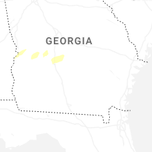
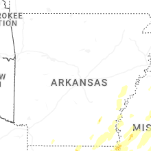
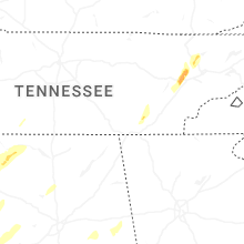
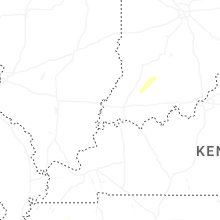
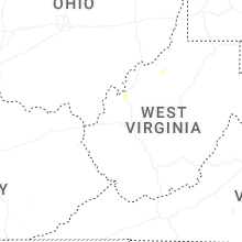
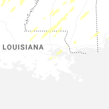
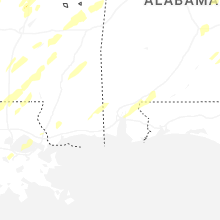
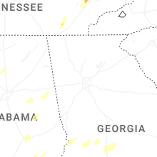
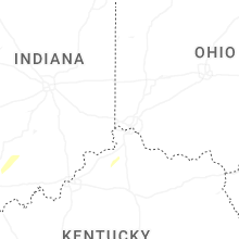
Hail Map for Saturday, March 15, 2025

Number of Impacted Households on 3/15/2025
0
Impacted by 1" or Larger Hail
0
Impacted by 1.75" or Larger Hail
0
Impacted by 2.5" or Larger Hail
Square Miles of Populated Area Impacted on 3/15/2025
0
Impacted by 1" or Larger Hail
0
Impacted by 1.75" or Larger Hail
0
Impacted by 2.5" or Larger Hail


Cities Most Affected by Hail Storms of 3/15/2025
| Hail Size | Demographics of Zip Codes Affected | ||||||
|---|---|---|---|---|---|---|---|
| City | Count | Average | Largest | Pop Density | House Value | Income | Age |
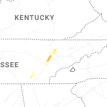
| Tuscumbia, AL | 1 | 2.75 | 2.75 | 103 | $72k | $30.6k | 41.8 |
| Russellville, AL | 1 | 2.00 | 2.00 | 76 | $66k | $26.7k | 35.5 |
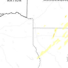
| Emerson, AR | 1 | 1.75 | 1.75 | 9 | $39k | $33.0k | 40.6 |
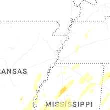
| Shannon, MS | 1 | 1.75 | 1.75 | 61 | $69k | $31.5k | 36.1 |
Hail and Wind Damage Spotted on 3/15/2025
Filter by Report Type:Hail ReportsWind Reports
States Impacted
Arkansas, Louisiana, Ohio, Tennessee, Mississippi, Georgia, Alabama, Missouri, Michigan, FloridaArkansas
| Local Time | Report Details |
|---|---|
| 7:00 AM CDT | Golf Ball sized hail reported near Emerson, AR, 52.5 miles NE of Shreveport, LA, report with multiple pictures. |
Louisiana
| Local Time | Report Details |
|---|---|
| 7:00 AM CDT | Quarter sized hail reported near Benton, LA, 13.1 miles NNE of Shreveport, LA, report via social media with picture. |
| 7:26 AM CDT | Quarter sized hail reported near Ruston, LA, 43.8 miles WSW of Bastrop, LA, mping report. |
| 7:40 AM CDT | Corrects previous non-tstm wnd dmg report from 1 wsw atlanta. reports of powerlines down on highway 471 southwest of atlant in winn county LA, 76 miles SE of Shreveport, LA |
| 8:05 AM CDT | Report of downed tre in morehouse county LA, 11.7 miles ESE of Bastrop, LA |
| 8:29 AM CDT | Multiple large tree limbs down in this area according to an mping repor in jackson county LA, 49.2 miles SW of Bastrop, LA |
| 10:08 AM CDT | Corrects previous tstm wnd dmg report from 1 sse lake providence. report of multiple trees downed along hwy-65s as well as damage to residences and businesses in downto in east carroll county LA, 42.8 miles E of Bastrop, LA |
| 10:56 AM CDT | Report of multiple trees downed along hwy-65s as well as damage to residences and businesses in downtown lake providenc in east carroll county LA, 42.8 miles E of Bastrop, LA |
| 11:40 AM CDT | Reports of trees damaged at holloway... la at ol mels farm and on hickory grove loo in rapides county LA, 82.9 miles N of Lafayette, LA |
| 4:23 PM CDT | Trees down along interstate 12 and 190. possible tornad in st. tammany county LA, 32.8 miles N of New Orleans, LA |
| 4:26 PM CDT | Trees and powerlines damaged near three rivers rd and wolverine dr. possible tornad in st. tammany county LA, 34.2 miles N of New Orleans, LA |
| 4:39 PM CDT | Quarter sized hail reported near Saint Rose, LA, 13.4 miles W of New Orleans, LA, quarter size hail. |
| 4:44 PM CDT | Quarter sized hail reported near Saint Rose, LA, 12.8 miles W of New Orleans, LA, report from mping: quarter (1.00 in.). |
| 4:56 PM CDT | Mesonet station xptn pontchartrain causewa in gmz530 county LA, 17.2 miles N of New Orleans, LA |
| 5:01 PM CDT | Quarter sized hail reported near Kenner, LA, 11.8 miles WNW of New Orleans, LA |
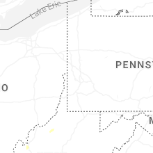
Ohio
| Local Time | Report Details |
|---|---|
| 8:20 AM EDT | Quarter sized hail reported near Sugarcreek, OH, 68.7 miles S of Cleveland, OH, quarter size hail report in sugarcreek relayed by broadcast media. time estimated via radar. |
| 3:50 PM EDT | Storm damage reported in van wert county OH, 17.9 miles ESE of Fort Wayne, IN |
Tennessee
| Local Time | Report Details |
|---|---|
| 7:27 AM CDT | Winds lofted a carport in pocahonta in mcnairy county TN, 65.6 miles WNW of Florence, AL |
| 8:30 AM CDT | Quarter sized hail reported near Brownsville, TN, 54.3 miles NE of Memphis, TN |
| 8:40 AM CDT | Estimated 60 mph winds at nws memphis offic in shelby county TN, 14.1 miles E of Memphis, TN |
| 11:10 AM EDT | Quarter sized hail reported near Athens, TN, 47.8 miles ENE of Chattanooga, TN |
| 3:08 PM CDT | Relayed via social media... photo of tree snapped and power pole down on blue creek roa in marshall county TN, 58 miles NE of Florence, AL |
| 3:18 PM CDT | Possible structure damage near kingdom road. tspotte in bedford county TN, 35.4 miles SSE of Nashville, TN |
| 3:19 PM CDT | Relayed from a tspotter... damage to a powerline and a tree at the intersection of longview road and pepper hil in bedford county TN, 38.2 miles SSE of Nashville, TN |
| 3:30 PM CDT | A privacy fence was blown down... partially blocking road along rucker rd near county farm r in rutherford county TN, 36.4 miles SE of Nashville, TN |
| 3:30 PM CDT | Trees were blown down at webb rd and barfield-crescent rd. time was estimated by rada in rutherford county TN, 34.2 miles SE of Nashville, TN |
| 3:45 PM CDT | Trees were blown down and blocking the road along jacobs hollow rd near bradyville pike. time estimated by rada in rutherford county TN, 42.6 miles SE of Nashville, TN |
| 3:55 PM CDT | Tree uprooted and damage to a metal building was reported near christian in bedford county TN, 36.8 miles SSE of Nashville, TN |
| 3:58 PM CDT | Rutherford county fire working 2 reports of large trees blocking roadways in christiana. 6700blk williams rd... 4500blk jones r in rutherford county TN, 36.1 miles SSE of Nashville, TN |
| 4:03 PM CDT | Debris blocking i-24 east at mile marker 89.2 in rutherford county. tree across roadway with all eastbound lanes blocke in rutherford county TN, 44.3 miles SE of Nashville, TN |
| 4:15 PM CDT | Numerous downed trees were reported in the mcminnville area. time estimate from rada in warren county TN, 50.8 miles NNW of Chattanooga, TN |
| 5:00 PM CDT | Trees down and structure damage to homes in palmer. time estimated by rada in grundy county TN, 25.6 miles NW of Chattanooga, TN |
| 5:09 PM CDT | Few trees dow in marion county TN, 31 miles WNW of Chattanooga, TN |
| 5:30 PM CDT | Few trees dow in sequatchie county TN, 27.8 miles NNW of Chattanooga, TN |
| 5:30 PM CDT | Several trees were blown down and minor structure damage was reported on the north side of jamestown near fairgrounds r in fentress county TN, 64.5 miles WNW of Knoxville, TN |
| 6:50 PM EDT | Quarter sized hail reported near Soddy Daisy, TN, 15.2 miles NE of Chattanooga, TN, hail up to 1 inch was photographed in lakesite... tn. |
| 6:53 PM EDT | Quarter sized hail reported near Soddy Daisy, TN, 15.5 miles NE of Chattanooga, TN, report from mping: quarter (1.00 in.). |
| 6:11 PM CDT | Several trees dow in marion county TN, 20.7 miles NW of Chattanooga, TN |
| 7:12 PM EDT | Several trees down and 1 inch hai in hamilton county TN, 28.2 miles NE of Chattanooga, TN |
| 6:35 PM CDT | Trees down. trees were twiste in bledsoe county TN, 30.6 miles N of Chattanooga, TN |
| 7:45 PM EDT | Trees dow in mcminn county TN, 45.7 miles SW of Knoxville, TN |
| 7:53 PM EDT | A few trees dow in morgan county TN, 35.8 miles WNW of Knoxville, TN |
| 8:20 PM EDT | Quarter sized hail reported near Oak Ridge, TN, 19.3 miles W of Knoxville, TN, lots of hail observed in oak ridge. largest was reported to be grape sized... roughly 1 inch. |
| 8:23 PM EDT | Quarter sized hail reported near Oak Ridge, TN, 17.8 miles WNW of Knoxville, TN, report from mping: quarter (1.00 in.). |
| 8:45 PM EDT | Quarter sized hail reported near Norris, TN, 17.6 miles NNW of Knoxville, TN |
| 8:56 PM EDT | Several trees dow in hamilton county TN, 25.6 miles NNE of Chattanooga, TN |
| 8:00 PM CDT | Quarter sized hail reported near Pikeville, TN, 47.3 miles NNE of Chattanooga, TN |
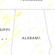
Mississippi
| Local Time | Report Details |
|---|---|
| 8:01 AM CDT | Storm damage reported in tunica county MS, 36.6 miles SSW of Memphis, TN |
| 8:18 AM CDT | Storm damage reported in carroll county MS, 73.2 miles W of Starkville, MS |
| 10:09 AM CDT | Law enforcement reported a tree down on a powerline near 101 dorrough rd in rulevill in sunflower county MS, 100.5 miles NNW of Jackson, MS |
| 11:10 AM CDT | Quarter sized hail reported near Water Valley, MS, 64.7 miles NW of Starkville, MS, quarter size hail reported on county road 220. |
| 11:20 AM CDT | Several homes destroyed on bear pen and in the hopedale road area. power lines across highway 1 south of grace. sharkey county em natalie perkin in issaquena county MS, 57.7 miles ENE of Bastrop, LA |
| 11:21 AM CDT | Corrects previous tstm wnd gst report from grace. farm shop destroyed... several houses destroyed south of grace on hwy 1. sharkey ema reporting injuries with ambulance in issaquena county MS, 57.6 miles ENE of Bastrop, LA |
| 11:22 AM CDT | Quarter sized hail reported near Oxford, MS, 66.7 miles SSE of Memphis, TN |
| 12:53 PM CDT | Local law enforcement reported several trees down near collier cv in rankin m in rankin county MS, 17 miles E of Jackson, MS |
| 1:12 PM CDT | Large tree on home on parkview s in monroe county MS, 40.8 miles NNE of Starkville, MS |
| 1:22 PM CDT | Law enforcement reported a tree down on loring rd. both lanes of traffic are blocke in madison county MS, 37 miles NNE of Jackson, MS |
| 1:34 PM CDT | A stand of trees snapped along the natchez trace parkway near the van vleet community. possible tornad in chickasaw county MS, 37.8 miles N of Starkville, MS |
| 1:54 PM CDT | Law enforcement reported multiple trees down near hwy 472 along with marble size hai in copiah county MS, 32.5 miles S of Jackson, MS |
| 2:05 PM CDT | Report of extensive tree damage along hwy-37 and damage to the roof of a structur in smith county MS, 55 miles SE of Jackson, MS |
| 2:05 PM CDT | Golf Ball sized hail reported near Shannon, MS, 45.5 miles N of Starkville, MS, reported golf ball sized hail in shannon area of lee county. |
| 2:24 PM CDT | Storm damage reported in forrest county MS, 81.6 miles WNW of Mobile, AL |
| 2:27 PM CDT | Local law enforcement reported multiple trees and powerlines down on new salem r in attala county MS, 47.3 miles WSW of Starkville, MS |
| 4:13 PM CDT | Reports of multiple power flashes on 192 watts rd. possible tornad in covington county MS, 61.7 miles SE of Jackson, MS |
Georgia
| Local Time | Report Details |
|---|---|
| 10:39 AM EDT | Multiple trees down near the intersection of hwy 113 and hwy 7 in carroll county GA, 36.8 miles W of Atlanta, GA |
| 10:53 AM EDT | Trees and powerlines down near the intersection of 27 and poseyville r in haralson county GA, 43.7 miles W of Atlanta, GA |
| 11:50 AM EDT | Trees reported down along hwy 78 in breme in haralson county GA, 43.7 miles W of Atlanta, GA |
| 10:36 PM EDT | Trees and power lines down across vinson mountain rao in polk county GA, 40.5 miles WNW of Atlanta, GA |
| 11:42 PM EDT | Tree downed on house of 200 block of william d in paulding county GA, 28.5 miles WNW of Atlanta, GA |
| 11:42 PM EDT | Tree downed on house on 400 block of indian hills dr. 3 residents trapped insid in paulding county GA, 28.3 miles WNW of Atlanta, GA |
| 11:44 PM EDT | Tree downed on house on 800 block of villa rica hw in paulding county GA, 27.3 miles WNW of Atlanta, GA |
| 11:44 PM EDT | Tree downed on house on 100 block of amber wa in paulding county GA, 27.6 miles WNW of Atlanta, GA |
| 11:44 PM EDT | Tree downed on vehicle on 200 block of villa rica hw in paulding county GA, 27.6 miles WNW of Atlanta, GA |
| 11:45 PM EDT | *** 1 inj *** tree downed on house on 300 block of dandy r in paulding county GA, 26.8 miles WNW of Atlanta, GA |
| 11:45 PM EDT | Tree reported down on a house near the intersection of oliver lane and bagby par in douglas county GA, 19.2 miles W of Atlanta, GA |
| 11:45 PM EDT | Tree downed on house of 100 block of ivy trace ln. roof collapse in paulding county GA, 27.9 miles WNW of Atlanta, GA |
| 11:47 PM EDT | Tree downed on house on 60 block of jade l in paulding county GA, 26.8 miles WNW of Atlanta, GA |
| 11:48 PM EDT | Tree downed on house on 30 block of folsom r in paulding county GA, 26.8 miles WNW of Atlanta, GA |
| 11:48 PM EDT | Tree downed on house on 60 block of smokey pat in paulding county GA, 26.8 miles WNW of Atlanta, GA |
| 11:49 PM EDT | Tree downed on house on 10 block of candy lilly l in paulding county GA, 26.7 miles WNW of Atlanta, GA |
| 11:50 PM EDT | Tree downed on house on 4800 block of mt. tabor church r in paulding county GA, 27 miles NW of Atlanta, GA |
| 12:00 AM EDT | Multiple trees down on s rt 100 near highway 7 in haralson county GA, 43.7 miles W of Atlanta, GA |
| 12:05 AM EDT | Tree blocking the road near the intersection of broad st and edgar little ci in haralson county GA, 55.2 miles W of Atlanta, GA |
| 12:15 AM EDT | Tree blocking the road near the intersection of cherokee dr and bowdon s in haralson county GA, 51.8 miles W of Atlanta, GA |
| 1:09 AM EDT | Tree across the road near the intersection of trace rd and mt tabor church r in paulding county GA, 25.4 miles WNW of Atlanta, GA |
| 1:20 AM EDT | Red light blown down along vernon r in troup county GA, 38.1 miles NE of Auburn, AL |
| 1:25 AM EDT | Tree down on house near the intersection of bouledvard st and ridge s in troup county GA, 38.8 miles NE of Auburn, AL |
| 1:30 AM EDT | Tree down on car along rutland circl in troup county GA, 40.6 miles NE of Auburn, AL |
| 6:25 AM EDT | Trees reported down on hwy 37 near sale city roa in mitchell county GA, 55.8 miles N of Tallahassee, FL |
| 6:50 AM EDT | Trees reported down on hwy 133 n south of doeru in colquitt county GA, 63.4 miles NNE of Tallahassee, FL |
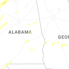
Alabama
| Local Time | Report Details |
|---|---|
| 2:13 PM CDT | Ping Pong Ball sized hail reported near Tuscumbia, AL, 12.3 miles SSW of Florence, AL, emergency management reported ping pong ball sized hail in new bethel alabama. |
| 2:20 PM CDT | Hen Egg sized hail reported near Russellville, AL, 24.7 miles SSW of Florence, AL, social media report received with photo of 2 inch hail. |
| 2:20 PM CDT | Tree downed in the 900 block of north montgomery ave in sheffield. time estimated by rada in colbert county AL, 2.5 miles SSW of Florence, AL |
| 2:20 PM CDT | Tree downed near the garage and cherokee roads intersection. time estimated from rada in colbert county AL, 2.9 miles SSE of Florence, AL |
| 2:26 PM CDT | Baseball sized hail reported near Tuscumbia, AL, 9.8 miles S of Florence, AL, emergency management reported baseball size hail in the colbert heights community. |
| 2:30 PM CDT | Quarter sized hail reported near Killen, AL, 9.2 miles ENE of Florence, AL, estimated 1 inch hail was reported in killen. |
| 2:34 PM CDT | Half Dollar sized hail reported near Tuscumbia, AL, 4.4 miles SSW of Florence, AL, social media report received for 1.25 inch hail. |
| 2:35 PM CDT | Ping Pong Ball sized hail reported near Tuscumbia, AL, 9.1 miles S of Florence, AL, estimated ping pong ball sized hail. |
| 2:39 PM CDT | Quarter sized hail reported near Florence, AL, 6.4 miles ENE of Florence, AL, emergency management reported quarter size hail one mile west of shoal creek on highway 72. |
| 2:45 PM CDT | Several trees uproote in lauderdale county AL, 20.2 miles ENE of Florence, AL |
| 2:45 PM CDT | Several trees dow in lauderdale county AL, 20.7 miles ENE of Florence, AL |
| 4:02 PM CDT | Numerous reports of trees down around the samantha and lake tuscaloosa areas... including tierce patton road. possible tornad in tuscaloosa county AL, 45.8 miles WSW of Birmingham, AL |
| 4:04 PM CDT | Tree down blocking highway 4 in tuscaloosa county AL, 47.7 miles WSW of Birmingham, AL |
| 4:10 PM CDT | Trees and power lines down on al-69... between buffalo ridge road and yellow creek road. lots of debris on the road. possible tornad in tuscaloosa county AL, 41.8 miles WSW of Birmingham, AL |
| 4:10 PM CDT | Tree downed in the 100 block of kentucky ave in sheffield. time estimated from rada in colbert county AL, 4.9 miles SSW of Florence, AL |
| 4:23 PM CDT | Several large trees down on al-69... just south of the tuscaloosa and walker county line. possible tornad in tuscaloosa county AL, 33.7 miles W of Birmingham, AL |
| 4:31 PM CDT | Trees down. possible tornad in walker county AL, 32.7 miles W of Birmingham, AL |
| 4:31 PM CDT | Trees down on paul bolton road. possible tornad in walker county AL, 30.9 miles WNW of Birmingham, AL |
| 4:40 PM CDT | Trees down. reported by 911 center. possible tornad in walker county AL, 27.8 miles WNW of Birmingham, AL |
| 5:28 PM CDT | Seven to 10 large trees down... blocking cr-13 near the alumuchee creek bridge. possible tornado. time estimated by rada in sumter county AL, 64 miles NW of Camden, AL |
| 6:44 PM CDT | Trees down on al-25 and cr-57... in the southern part of hale county. possible tornad in hale county AL, 42.4 miles NNW of Camden, AL |
| 6:52 PM CDT | Trees down blocking the road on al-61... and near cr-16... both in and near newbern. possible tornad in hale county AL, 44.1 miles NNW of Camden, AL |
| 8:02 PM CDT | Extensive damage to a trailer park in the city of calera. possible tornad in shelby county AL, 28.5 miles S of Birmingham, AL |
| 8:21 PM CDT | Several trees down in the quail run are in shelby county AL, 12 miles SSE of Birmingham, AL |
| 8:43 PM CDT | Damage reported at winterboro high schoo in talladega county AL, 37.9 miles ESE of Birmingham, AL |
Missouri
| Local Time | Report Details |
|---|---|
| 3:29 PM CDT | Roof blown off house at 345 bradshaw west alton as well as power poles and out buildings dow in st. charles county MO, 16.9 miles N of Saint Louis, MO |
Michigan
| Local Time | Report Details |
|---|---|
| 4:55 PM EDT | Measured at lenawee county airport in lenawee county MI, 76.2 miles NE of Fort Wayne, IN |
| 5:18 PM EDT | Emergency manager relayed spotter report of 60 mph estimated wind gust at intersection of ann arbor saline rd and waterwork in washtenaw county MI, 57.6 miles S of Flint, MI |
| 5:25 PM EDT | Emergency manager reports wires down with pole on fire at foley ave in ypsilanti tw in washtenaw county MI, 54.2 miles S of Flint, MI |
| 5:30 PM EDT | Em reports large tree down on fire on prospect hill rd in washtenaw county MI, 60.4 miles SSW of Flint, MI |
| 5:32 PM EDT | Em reports large tree branch down on gas meter at apartment complex on bridle run in pittsfield tw in washtenaw county MI, 54.6 miles S of Flint, MI |
| 5:33 PM EDT | Emergency manager reports large tree on fire with power lines down at the intersection of nottingham rd and independence blvd in ann arbo in washtenaw county MI, 52.5 miles S of Flint, MI |
| 5:36 PM EDT | Emergency manager reports utility pole leaning with power lines down at miller rd in scio tw in washtenaw county MI, 48.8 miles S of Flint, MI |
Florida
| Local Time | Report Details |
|---|---|
| 7:00 AM EDT | Mesonet station 0742w fswn wakulla shell point beach reported a gust of 66 mp in wakulla county FL, 26.2 miles S of Tallahassee, FL |
Connect with Interactive Hail Maps