

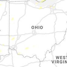
Hail Map for Friday, October 23, 2020

Number of Impacted Households on 10/23/2020
0
Impacted by 1" or Larger Hail
0
Impacted by 1.75" or Larger Hail
0
Impacted by 2.5" or Larger Hail
Square Miles of Populated Area Impacted on 10/23/2020
0
Impacted by 1" or Larger Hail
0
Impacted by 1.75" or Larger Hail
0
Impacted by 2.5" or Larger Hail


Cities Most Affected by Hail Storms of 10/23/2020
| Hail Size | Demographics of Zip Codes Affected | ||||||
|---|---|---|---|---|---|---|---|
| City | Count | Average | Largest | Pop Density | House Value | Income | Age |
Hail and Wind Damage Spotted on 10/23/2020
Filter by Report Type:Hail ReportsWind Reports
States Impacted
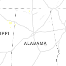
Texas, Michigan, Arkansas, Illinois, Ohio, Indiana, Tennessee, Kentucky, New York, MississippiTexas
| Local Time | Report Details |
|---|---|
| 7:40 AM CDT | Wind gust to 60 mph at 7:40 a. in hood county TX, 57.4 miles WSW of Dallas, TX |
| 2:35 PM CDT | Palm tree blown dow in harris county TX, 20.4 miles NE of Houston, TX |
| 2:44 PM CDT | 1-inch tree limbs broken; shingles blown of in harris county TX, 1.4 miles WNW of Houston, TX |
Michigan
| Local Time | Report Details |
|---|---|
| 1:08 PM EDT | Quarter sized hail reported near Saint Charles, MI, 30.9 miles NW of Flint, MI, mping report of 1 inch hail by st charles. power outages also reported in the area. |
| 1:25 PM EDT | Dispatch is reporting wires down at russel and gilmore street in saginaw county MI, 30.2 miles NNW of Flint, MI |
| 1:50 PM EDT | Several trees down in eaton rapid in eaton county MI, 60.3 miles ESE of Grand Rapids, MI |
| 2:00 PM EDT | Trees across sleight road and chandler roa in clinton county MI, 42.4 miles WSW of Flint, MI |
| 2:00 PM EDT | Metal grain silo blown down. the roof of the garage was also blown off at the same far in huron county MI, 65.8 miles NNE of Flint, MI |
| 2:02 PM EDT | Tree down across upton and stoll roa in clinton county MI, 39 miles WSW of Flint, MI |
| 2:02 PM EDT | Trees across cutler road and center roa in clinton county MI, 38.7 miles WSW of Flint, MI |
| 2:02 PM EDT | Trees across the intersection of clise road and webster roa in clinton county MI, 40.7 miles WSW of Flint, MI |
| 2:02 PM EDT | Tree across intersection of upton and clark roa in clinton county MI, 38.8 miles WSW of Flint, MI |
| 2:07 PM EDT | Multiple reports relayed by county dispatch of trees and wires down around the towns of pinnebog... kinde... and meade twp. widespread power outages are reported across in huron county MI, 71.2 miles NNE of Flint, MI |
| 2:12 PM EDT | Report via ham radio of a large tree down in the city of owoss in shiawassee county MI, 25 miles W of Flint, MI |
| 2:14 PM EDT | Ham radio report of tree and branches down near n state rd and m2 in shiawassee county MI, 22 miles W of Flint, MI |
| 2:19 PM EDT | County dispatch has multiple reports of trees down along m25 between port hope and grind stone cit in huron county MI, 78.5 miles SSE of Alpena, MI |
| 2:36 PM EDT | Media relayed social media reports of trees down taking down wires with them in clio. additional ham radio report via county dispatch of multiple trees and wires down a in genesee county MI, 14 miles N of Flint, MI |
| 2:40 PM EDT | Trees down across county farm road and n dearing roa in jackson county MI, 66.6 miles SW of Flint, MI |
| 2:47 PM EDT | Quarter sized hail reported near Milan, MI, 67 miles S of Flint, MI, spotter report of 1 inch hail. |
| 3:01 PM EDT | County dispatch reports trees down near w oregon and millville rds. multiple additional reports of trees down between elba and lapeer cit in lapeer county MI, 17.8 miles E of Flint, MI |
| 3:12 PM EDT | Numerous trees down near m53 and snover r in sanilac county MI, 43.2 miles NE of Flint, MI |
| 4:06 PM EDT | Picture via social media of tree snapped at dundee high schoo in monroe county MI, 72.5 miles S of Flint, MI |
Arkansas
| Local Time | Report Details |
|---|---|
| 1:55 PM CDT | A 12 inch diameter tree was blown over near the intersection of denny and weldon roa in pulaski county AR, 13.6 miles W of Little Rock, AR |
Illinois
| Local Time | Report Details |
|---|---|
| 2:30 PM CDT | Estimated 60 mph winds and dime size hail. limbs dow in edwards county IL, 35.9 miles NW of Evansville, IN |
Ohio
| Local Time | Report Details |
|---|---|
| 3:37 PM EDT | Quarter sized hail reported near Huron, OH, 43.4 miles W of Cleveland, OH, quarter sized hail. |
| 5:18 PM EDT | Downed trees and powerlines. time estimated via rada in wood county OH, 75.8 miles E of Fort Wayne, IN |
| 5:21 PM EDT | Asos station kfdy findla in hancock county OH, 74.8 miles E of Fort Wayne, IN |
| 5:27 PM EDT | Multiple 1 to 2 inch diameter limbs dow in hancock county OH, 75.7 miles E of Fort Wayne, IN |
| 5:27 PM EDT | Tree down across road on hull ave. time estimated via rada in hancock county OH, 76.2 miles E of Fort Wayne, IN |
| 5:30 PM EDT | 54 knot peak wind. mesonet station twco1 8 ene orego in lez142 county OH, 82.4 miles W of Cleveland, OH |
| 5:50 PM EDT | Tree down on powerlines. time estimated via rada in seneca county OH, 79.8 miles WSW of Cleveland, OH |
| 5:56 PM EDT | Numerous trees and powerlines reported down across south bass islan in ottawa county OH, 59.9 miles W of Cleveland, OH |
| 6:00 PM EDT | Tree down in roadway on sr 101 near sr 19. time estimated via rada in seneca county OH, 71.7 miles WSW of Cleveland, OH |
| 6:02 PM EDT | Quarter sized hail reported near Independence, OH, 10.3 miles SSE of Cleveland, OH, quarter sized hail. |
| 6:26 PM EDT | Trained spotter shared pictures on social media of multiple trees uproote in montgomery county OH, 42.4 miles N of Cincinnati, OH |
| 6:27 PM EDT | Quarter sized hail reported near Rocky River, OH, 9.6 miles WSW of Cleveland, OH |
| 6:27 PM EDT | Trees down at w 210th st and lorain rd and on w 229th st south of lorain r in cuyahoga county OH, 9.1 miles WSW of Cleveland, OH |
| 6:28 PM EDT | Quarter sized hail reported near Huron, OH, 45.7 miles W of Cleveland, OH |
| 6:56 PM EDT | Tree of unknown size down on house. time estimated via rada in lorain county OH, 24 miles W of Cleveland, OH |
| 7:00 PM EDT | Tree down on wires. time estimated from rada in lorain county OH, 21.3 miles W of Cleveland, OH |
| 7:25 PM EDT | 51 knot peak wind. mesonet station xcle cleveland - edgewate in lez146 county OH, 2.1 miles W of Cleveland, OH |
| 7:37 PM EDT | Tree down on scottsdale blvd. time estimated via rada in cuyahoga county OH, 7.9 miles ESE of Cleveland, OH |
| 7:37 PM EDT | Road closed due to large tree across the road. time estimated via rada in cuyahoga county OH, 4.7 miles E of Cleveland, OH |
| 7:42 PM EDT | Tree down on wires. time estimated from rada in cuyahoga county OH, 10.7 miles ENE of Cleveland, OH |
| 7:49 PM EDT | Tree down. time estimated from rada in geauga county OH, 19.2 miles E of Cleveland, OH |
| 7:55 PM EDT | Tree down on sperry rd & fairmount r in geauga county OH, 20.8 miles E of Cleveland, OH |
| 7:58 PM EDT | Trees and wires down. time estimated via rada in geauga county OH, 22.1 miles E of Cleveland, OH |
Indiana
| Local Time | Report Details |
|---|---|
| 3:54 PM EDT | Quarter sized hail reported near Greenfield, IN, 18.2 miles E of Indianapolis, IN, report from mping: quarter (1.00 in.). |
| 5:05 PM EDT | Quarter sized hail reported near Bedford, IN, 66.9 miles NW of Louisville, KY, at buddah. |
| 5:14 PM EDT | 30 foot tree limb... 16 inches in diameter... reported down by parks dept... blocking road... but has since been remove in dubois county IN, 44.8 miles NE of Evansville, IN |
| 5:15 PM EDT | Tree blown into apartment house. time estimated from rada in lawrence county IN, 66.4 miles NW of Louisville, KY |
| 5:35 PM EDT | Quarter sized hail reported near Borden, IN, 35.8 miles NNW of Louisville, KY, reported at borden... in. |
| 5:51 PM EDT | Ping Pong Ball sized hail reported near Sellersburg, IN, 28.5 miles N of Louisville, KY, viewer photo of 1.5 inch hail relayed local tv met. |
| 6:05 PM EDT | Dispatch reports trees down around the county. time estimated from radar from 605-635 p in jennings county IN, 58 miles W of Cincinnati, OH |
Tennessee
| Local Time | Report Details |
|---|---|
| 3:09 PM CDT | Quarter sized hail reported near Huntingdon, TN, 11.5 miles SE of Mc Kenzie, TN, quarter size hail reported in rosser area of huntingdon. |
| 3:10 PM CDT | Telephone lines down on seminary street in hollow rock... t in carroll county TN, 15.4 miles ESE of Mc Kenzie, TN |
| 4:50 PM CDT | Quarter sized hail reported near Charlotte, TN, 26.8 miles WNW of Nashville, TN, photo sent to wkrn showed quarter size hail fell near cumberland furnace |
Kentucky
| Local Time | Report Details |
|---|---|
| 3:22 PM CDT | Tree down on ky121 & ky33 in graves county KY, 50.2 miles NNW of Mc Kenzie, TN |
| 3:22 PM CDT | Trees down along the mccracken/ballard county line near lovelaceville. time estimated by rada in mccracken county KY, 46.1 miles ESE of Cape Girardeau, MO |
| 3:40 PM CDT | Trees down over roadwa in todd county KY, 52.9 miles NNW of Nashville, TN |
| 3:45 PM CDT | Quarter sized hail reported near Elkton, KY, 53.1 miles NNW of Nashville, TN, near intersection of highways 178 and 106. |
| 3:50 PM CDT | Tree down on husband roa in mccracken county KY, 55.7 miles ESE of Cape Girardeau, MO |
| 6:40 PM EDT | Tree down in new castle. time estimated from tsd in henry county KY, 42.6 miles NE of Louisville, KY |
| 6:40 PM EDT | Large limb snapped based on pictures relayed to a broadcast media meteorologis in jefferson county KY, 10.9 miles NW of Louisville, KY |
| 6:50 PM EDT | Some trees down in a couple areas...port royal road and nearby vance roa in henry county KY, 49.7 miles SW of Cincinnati, OH |
New York
| Local Time | Report Details |
|---|---|
| 8:55 PM EDT | Storm damage reported in lez041 county NY, 2.5 miles S of Buffalo, NY |
Mississippi
| Local Time | Report Details |
|---|---|
| 8:20 PM CDT | Picture of a tree down on a car and home in the belhaven neighborhood. likely sub-severe wind gust along an advancing outflow boundar in hinds county MS, 1.6 miles NNE of Jackson, MS |
Connect with Interactive Hail Maps