

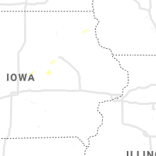
Hail Map for Thursday, October 22, 2020

Number of Impacted Households on 10/22/2020
0
Impacted by 1" or Larger Hail
0
Impacted by 1.75" or Larger Hail
0
Impacted by 2.5" or Larger Hail
Square Miles of Populated Area Impacted on 10/22/2020
0
Impacted by 1" or Larger Hail
0
Impacted by 1.75" or Larger Hail
0
Impacted by 2.5" or Larger Hail


Cities Most Affected by Hail Storms of 10/22/2020
| Hail Size | Demographics of Zip Codes Affected | ||||||
|---|---|---|---|---|---|---|---|
| City | Count | Average | Largest | Pop Density | House Value | Income | Age |
Hail and Wind Damage Spotted on 10/22/2020
Filter by Report Type:Hail ReportsWind Reports
Wisconsin
| Local Time | Report Details |
|---|---|
| 4:16 PM CDT | Quarter sized hail reported near Stevens Point, WI, 76.6 miles W of Green Bay, WI |
Iowa
| Local Time | Report Details |
|---|---|
| 6:08 PM CDT | Quarter sized hail reported near Hudson, IA, 48.1 miles WNW of Cedar Rapids, IA, kwwl relayed public report and image of roughly quarter sized hail near voorhies. |
| 6:11 PM CDT | Quarter sized hail reported near Hudson, IA, 48.6 miles NW of Cedar Rapids, IA, kwwl relayed public report and image of roughly quarter sized hail south of hudson. |
| 6:20 PM CDT | Quarter sized hail reported near Maxwell, IA, 23.5 miles NNE of Des Moines, IA, trained spotter relayed image of roughly penny to nickel sized hail. |
Connect with Interactive Hail Maps