

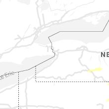
Hail Map for Wednesday, September 15, 2021

Number of Impacted Households on 9/15/2021
0
Impacted by 1" or Larger Hail
0
Impacted by 1.75" or Larger Hail
0
Impacted by 2.5" or Larger Hail
Square Miles of Populated Area Impacted on 9/15/2021
0
Impacted by 1" or Larger Hail
0
Impacted by 1.75" or Larger Hail
0
Impacted by 2.5" or Larger Hail


Cities Most Affected by Hail Storms of 9/15/2021
| Hail Size | Demographics of Zip Codes Affected | ||||||
|---|---|---|---|---|---|---|---|
| City | Count | Average | Largest | Pop Density | House Value | Income | Age |
Hail and Wind Damage Spotted on 9/15/2021
Filter by Report Type:Hail ReportsWind Reports
States Impacted
New York, Pennsylvania, Vermont, New Hampshire, Maine, Maryland, Oklahoma, MinnesotaNew York
| Local Time | Report Details |
|---|---|
| 12:30 PM EDT | Tree on wires on county road 31. time estimated from rada in otsego county NY, 48.6 miles W of Schenectady, NY |
| 12:37 PM EDT | Trees dow in montgomery county NY, 32.5 miles W of Schenectady, NY |
| 12:53 PM EDT | Quarter sized hail reported near Fultonville, NY, 23.8 miles WNW of Schenectady, NY, spotter indicated hail was increasing in size at time of report. |
| 1:20 PM EDT | Trees and wires down on mccumber road. time estimated from rada in otsego county NY, 63.5 miles SE of Syracuse, NY |
| 1:45 PM EDT | Quarter sized hail reported near Bath, NY, 77.7 miles SW of Syracuse, NY |
| 1:47 PM EDT | Wires down. time estimated by rada in saratoga county NY, 25.5 miles NNE of Schenectady, NY |
| 2:02 PM EDT | Law enforcement reports a couple trees down on wires on burke rd near county rt 67 in saratoga county NY, 21.2 miles NE of Schenectady, NY |
| 2:10 PM EDT | Trees and wires down in town of bath. specific location unknow in steuben county NY, 77.2 miles SW of Syracuse, NY |
| 2:14 PM EDT | Tree down on the roa in schuyler county NY, 63.6 miles SW of Syracuse, NY |
| 2:15 PM EDT | Trees and wires dow in steuben county NY, 73.4 miles SW of Syracuse, NY |
| 4:00 PM EDT | Tree and wires down. time estimated from rada in otsego county NY, 54.1 miles SE of Syracuse, NY |
| 4:03 PM EDT | Large tree limbs down with estimated 65 mph wind gus in rensselaer county NY, 23.5 miles SE of Schenectady, NY |
| 4:40 PM EDT | Tree down across the roa in otsego county NY, 46.1 miles W of Schenectady, NY |
Pennsylvania
| Local Time | Report Details |
|---|---|
| 1:00 PM EDT | Trees down blocking roa in bradford county PA, 57.1 miles NW of Scranton, PA |
| 1:35 PM EDT | Trees down blocking road near the old litchfield schoo in bradford county PA, 54 miles NW of Scranton, PA |
| 1:57 PM EDT | Multiple wires down on orchard road on the psu campu in centre county PA, 1.8 miles N of State College, PA |
| 2:00 PM EDT | Trees down on worlds end rd (pa-309 in sullivan county PA, 49.3 miles W of Scranton, PA |
| 2:00 PM EDT | Trees and wires dow in centre county PA, 9.1 miles NNE of State College, PA |
| 2:00 PM EDT | Trees down hillary rd. spring tw in centre county PA, 8.8 miles NNE of State College, PA |
| 2:34 PM EDT | Tree on wires with a fir in centre county PA, 32.1 miles ENE of State College, PA |
| 3:30 PM EDT | Multiple trees down near pa routes 45 and 40 in northumberland county PA, 52.8 miles ENE of State College, PA |
| 3:45 PM EDT | Trees and wires down in the limestone are in montour county PA, 59.7 miles ENE of State College, PA |
| 3:50 PM EDT | Trees down in the vicinity of decatu in mifflin county PA, 22.7 miles ESE of State College, PA |
| 5:35 PM EDT | Tree down on gardner rd... time estimated from rada in lackawanna county PA, 6.9 miles ESE of Scranton, PA |
| 5:39 PM EDT | Large tree down on road blocking traffi in lackawanna county PA, 7.2 miles ESE of Scranton, PA |
| 5:39 PM EDT | Tree down on house. no injurie in lackawanna county PA, 6.4 miles ESE of Scranton, PA |
| 6:27 PM EDT | Multiple reports of trees and wires down in pine grove and washington township in schuylkill county PA, 68 miles SSW of Scranton, PA |
Vermont
| Local Time | Report Details |
|---|---|
| 1:26 PM EDT | Several trees down in middleton spring in rutland county VT, 62 miles NE of Schenectady, NY |
| 2:09 PM EDT | Trees and powerlines down in bridgewate in windsor county VT, 68.3 miles SSE of Burlington, VT |
| 2:20 PM EDT | Trees and powerlines down in woodstoc in windsor county VT, 67.8 miles SSE of Burlington, VT |
| 2:22 PM EDT | Trees and powerlines dow in caledonia county VT, 57.9 miles ESE of Burlington, VT |
| 2:39 PM EDT | Trees and powerlines down along us in orange county VT, 63.4 miles ESE of Burlington, VT |
| 2:41 PM EDT | Trees and powerlines down along us in orange county VT, 63.4 miles ESE of Burlington, VT |
| 3:02 PM EDT | Law enforcement reports tree down near old west rd and rt 7a. time estimated from rada in bennington county VT, 40.7 miles ENE of Schenectady, NY |
| 3:02 PM EDT | Law enforcement reports tree down near timber trail rd and rt 7a. time estimated from radar in bennington county VT, 41.4 miles ENE of Schenectady, NY |
| 3:03 PM EDT | Tree down on powerlines along plains roa in windsor county VT, 83.2 miles SSE of Burlington, VT |
| 3:10 PM EDT | Law enforcement reports tree down near the intersection of main st and south rd in peru. time estimated from radar in bennington county VT, 60.1 miles ENE of Schenectady, NY |
| 3:12 PM EDT | Law enforcement reports tree down on north rd in peru. time estimated from rada in bennington county VT, 60.8 miles ENE of Schenectady, NY |
New Hampshire
| Local Time | Report Details |
|---|---|
| 2:40 PM EDT | Half Dollar sized hail reported near Errol, NH, 82 miles NNW of Portland, ME |
| 2:41 PM EDT | Numerous trees down across littleton. time estimated based on rada in grafton county NH, 72.4 miles E of Burlington, VT |
| 2:43 PM EDT | Numerous trees down across lancaster. time estimated based on rada in coos county NH, 81.2 miles E of Burlington, VT |
| 3:15 PM EDT | Numerous trees down across berlin. time estimated based on rada in coos county NH, 72.8 miles NW of Portland, ME |
| 3:20 PM EDT | Trees down near koa campground off highway 175 south of woodstoc in grafton county NH, 73.7 miles WNW of Portland, ME |
| 3:45 PM EDT | One tree and power line down on upper mad river r in grafton county NH, 69.9 miles WNW of Portland, ME |
| 4:08 PM EDT | Trees down across unity. time estimated based on rada in sullivan county NH, 91.3 miles ENE of Schenectady, NY |
| 4:10 PM EDT | Trees down across claremont. time estimated based on rada in sullivan county NH, 87.1 miles SSE of Burlington, VT |
| 4:10 PM EDT | Numerous trees down north of walpole. penny size hail also reporte in cheshire county NH, 79 miles ENE of Schenectady, NY |
| 4:18 PM EDT | Quarter sized hail reported near North Sandwich, NH, 58.9 miles WNW of Portland, ME |
| 4:20 PM EDT | Half Dollar sized hail reported near Washington, NH, 96.7 miles ENE of Schenectady, NY |
| 4:30 PM EDT | Quarter sized hail reported near Bradford, NH, 90.9 miles WSW of Portland, ME |
| 5:09 PM EDT | Quarter sized hail reported near Dublin, NH, 83 miles NNW of Providence, RI, time estimated based on radar. |
| 5:12 PM EDT | Trees down on mcveagh rd. diameter of trees up to 7 inches. time estimated based on rada in cheshire county NH, 83.4 miles NNW of Providence, RI |
| 5:12 PM EDT | Half Dollar sized hail reported near Wolfeboro, NH, 46.7 miles W of Portland, ME, leaves shredded from hail. |
| 5:22 PM EDT | Trees down south of peterborough along us hwy 202. small hail also fell. time estimated by rada in hillsborough county NH, 76.2 miles NNW of Providence, RI |
| 5:25 PM EDT | Half Dollar sized hail reported near Sanbornville, NH, 39.8 miles W of Portland, ME |
| 5:40 PM EDT | Trees down in the town of sharon. one tree blocking nh hwy 123. time estimated by rada in hillsborough county NH, 74.3 miles NNW of Providence, RI |
| 6:04 PM EDT | 1 tree down near town green. time estimated by rada in merrimack county NH, 85.3 miles WSW of Portland, ME |
Maine
| Local Time | Report Details |
|---|---|
| 3:42 PM EDT | Tree down across east andover road in andover me. time estimated based on rada in oxford county ME, 71.9 miles NNW of Portland, ME |
| 4:42 PM EDT | Large 100 foot tall pine tree came down in a spotters yard which hit their roof and crushed 2 cars. time estimated based on rada in oxford county ME, 43.2 miles NNW of Portland, ME |
| 4:48 PM EDT | 2 trees down 1/2 mile east of downtown norway. time estimated by rada in oxford county ME, 40.4 miles NNW of Portland, ME |
| 5:00 PM EDT | One tree fell on a powerline and knocked out power for about 3 1/2 hour in piscataquis county ME, 44.1 miles WNW of Bangor, ME |
| 5:09 PM EDT | Tree down across martin stream road. time estimated based on rada in somerset county ME, 41.3 miles W of Bangor, ME |
| 5:15 PM EDT | Multiple trees down reported across the lewiston/auburn area. time estimated based on rada in androscoggin county ME, 30.5 miles N of Portland, ME |
| 5:36 PM EDT | Tree on wires. time estimated by rada in york county ME, 34 miles WSW of Portland, ME |
| 5:40 PM EDT | Pole and wire down. time estimated by rada in york county ME, 30.9 miles WSW of Portland, ME |
| 5:41 PM EDT | Trees down... time estimated by rada in kennebec county ME, 48.8 miles NNE of Portland, ME |
| 5:45 PM EDT | 2 trees on wires. time estimated by rada in york county ME, 35.1 miles WSW of Portland, ME |
| 5:50 PM EDT | Wire on road. time estimated by rada in york county ME, 29.9 miles WSW of Portland, ME |
Maryland
| Local Time | Report Details |
|---|---|
| 3:47 PM EDT | Tree branches and wires down on lower town creek roa in allegany county MD, 82.5 miles ENE of Elkins, WV |
| 5:25 PM EDT | Multiple trees and wires down in and near leitersbur in washington county MD, 60.6 miles WNW of Baltimore, MD |
| 5:27 PM EDT | Tree down on clopper road near old forge roa in washington county MD, 61.5 miles WNW of Baltimore, MD |
| 5:31 PM EDT | Tree down on little antietam road near winding creek roa in washington county MD, 60.8 miles WNW of Baltimore, MD |
| 5:59 PM EDT | Multiple trees and wires down in and near smithsbur in washington county MD, 57.3 miles WNW of Baltimore, MD |
| 6:45 PM EDT | Tree down on mapleville road near chewsville roa in washington county MD, 58.1 miles WNW of Baltimore, MD |
| 7:03 PM EDT | Several wires and branches down near forest school roa in frederick county MD, 53.9 miles WNW of Baltimore, MD |
| 7:07 PM EDT | Tree down on loy wolfe road near pleasant walk roa in frederick county MD, 44.5 miles WNW of Baltimore, MD |
| 9:40 PM EDT | A couple of trees and branches were blown down near stree in harford county MD, 28.9 miles NNE of Baltimore, MD |
| 10:30 PM EDT | Minor tree damage was reported in aberdee in harford county MD, 28 miles ENE of Baltimore, MD |
| 10:38 PM EDT | Storm damage reported in harford county MD, 26.6 miles ENE of Baltimore, MD |
Oklahoma
| Local Time | Report Details |
|---|---|
| 4:30 PM CDT | Broadcast media relayed a photo on twitter from a trained spotter of a broken large tree limb. also reporting a power pole down. time estimated by the tulsa terminal do in osage county OK, 15.2 miles N of Tulsa, OK |
| 5:00 PM CDT | Video of tree limbs downed near 56th and peoria in tulsa found via snap maps. time estimate in tulsa county OK, 4.3 miles ESE of Tulsa, OK |
| 5:16 PM CDT | Storm damage reported in tulsa county OK, 7.6 miles S of Tulsa, OK |
Minnesota
| Local Time | Report Details |
|---|---|
| 11:33 PM CDT | Via ndaw in polk county MN, 70.4 miles SW of Roseau, MN |
Connect with Interactive Hail Maps