

Hail Map for Grover Beach, CA
The Grover Beach, CA area has had 0 reports of on-the-ground hail by trained spotters, and has been under severe weather warnings 4 times during the past 12 months. Doppler radar has detected hail at or near Grover Beach, CA on 1 occasion.
| Name: | Grover Beach, CA |
| Where Located: | 17.6 miles SE of Los Osos, CA |
| Map: | Google Map for Grover Beach, CA |
| Population: | 13156 |
| Housing Units: | 5748 |
| More Info: | Search Google for Grover Beach, CA |
0
The Top Recent Hail Date for Grover Beach, CA is Thursday, July 7, 2011 (1st out of 1)

Hail and Wind Damage Spotted near Grover Beach, CA
| Date / Time | Report Details |
|---|---|
| 2/17/2026 7:36 PM PST |
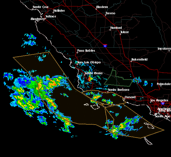
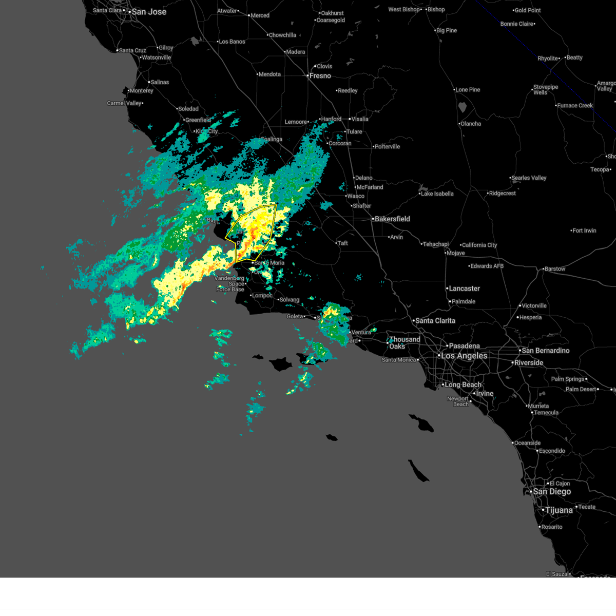 At 736 pm pst, severe thunderstorms were located along a line extending from 28 miles east of atascadero to 18 miles northwest of vandenberg space force base, moving east at 25 mph (radar indicated). Hazards include 70 mph wind gusts. brief weak tornado possible. Expect considerable tree damage. damage is likely to mobile homes, roofs, and outbuildings. Locations impacted include, santa maria, san luis obispo, pismo beach, arroyo grande, nipomo, grover beach, oceano, black mountain, avila beach, shell beach, lake lopez, and highway 101 over cuesta grade. At 736 pm pst, severe thunderstorms were located along a line extending from 28 miles east of atascadero to 18 miles northwest of vandenberg space force base, moving east at 25 mph (radar indicated). Hazards include 70 mph wind gusts. brief weak tornado possible. Expect considerable tree damage. damage is likely to mobile homes, roofs, and outbuildings. Locations impacted include, santa maria, san luis obispo, pismo beach, arroyo grande, nipomo, grover beach, oceano, black mountain, avila beach, shell beach, lake lopez, and highway 101 over cuesta grade.
|
| 2/17/2026 6:59 PM PST |
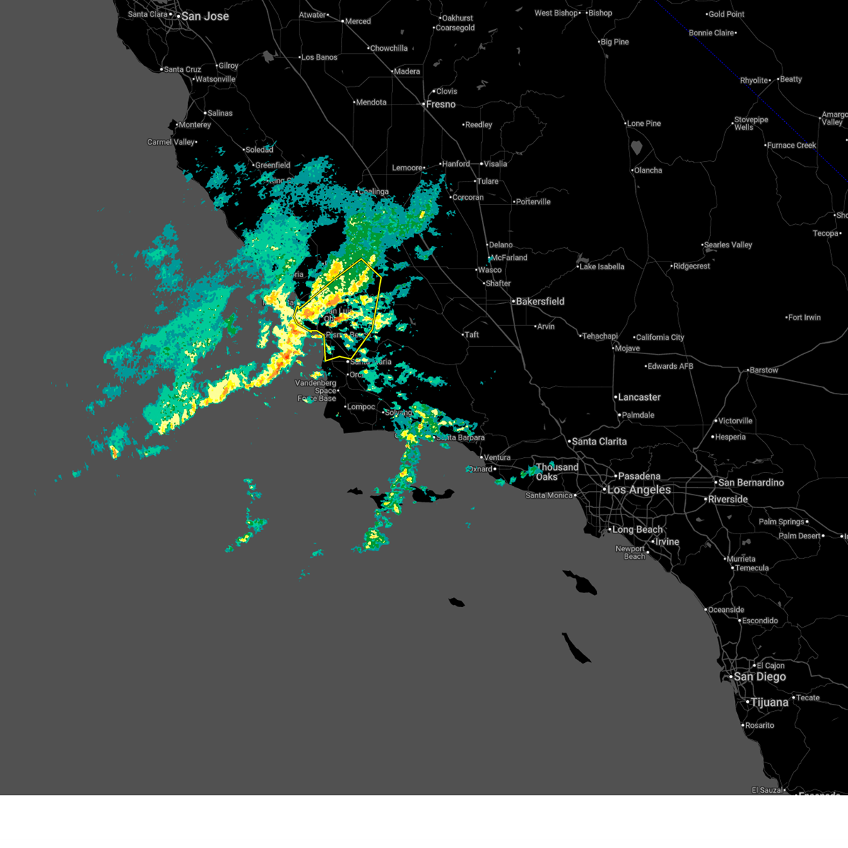 At 659 pm pst, severe thunderstorms were located along a line extending from 26 miles east of paso robles to 45 miles west of vandenberg space force base, moving east at 30 mph (radar indicated). Hazards include 70 mph damaging wind gusts. brief weak tornado possible. Expect considerable tree damage. damage is likely to mobile homes, roofs, and outbuildings. Locations impacted include, santa maria, san luis obispo, pismo beach, atascadero, arroyo grande, nipomo, grover beach, oceano, black mountain, santa margarita, avila beach, diablo canyon, baywood-los osos, highway 101 over cuesta grade, shell beach, and lake lopez. At 659 pm pst, severe thunderstorms were located along a line extending from 26 miles east of paso robles to 45 miles west of vandenberg space force base, moving east at 30 mph (radar indicated). Hazards include 70 mph damaging wind gusts. brief weak tornado possible. Expect considerable tree damage. damage is likely to mobile homes, roofs, and outbuildings. Locations impacted include, santa maria, san luis obispo, pismo beach, atascadero, arroyo grande, nipomo, grover beach, oceano, black mountain, santa margarita, avila beach, diablo canyon, baywood-los osos, highway 101 over cuesta grade, shell beach, and lake lopez.
|
| 2/17/2026 6:55 PM PST |
 At 654 pm pst, severe thunderstorms were located along a line extending from 24 miles east of paso robles to 47 miles west of vandenberg space force base, moving east at 30 mph (radar indicated). Hazards include 60 mph wind gusts. brief weak tornado possible. Expect damage to roofs, siding, and trees. Locations impacted include, santa maria, san luis obispo, pismo beach, atascadero, arroyo grande, nipomo, grover beach, oceano, black mountain, santa margarita, avila beach, diablo canyon, baywood-los osos, highway 101 over cuesta grade, shell beach, and lake lopez. At 654 pm pst, severe thunderstorms were located along a line extending from 24 miles east of paso robles to 47 miles west of vandenberg space force base, moving east at 30 mph (radar indicated). Hazards include 60 mph wind gusts. brief weak tornado possible. Expect damage to roofs, siding, and trees. Locations impacted include, santa maria, san luis obispo, pismo beach, atascadero, arroyo grande, nipomo, grover beach, oceano, black mountain, santa margarita, avila beach, diablo canyon, baywood-los osos, highway 101 over cuesta grade, shell beach, and lake lopez.
|
| 2/17/2026 6:13 PM PST |
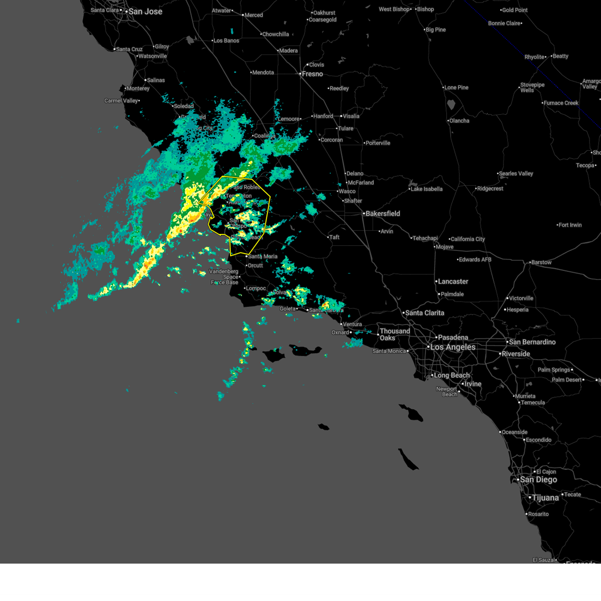 Svrlox the national weather service in oxnard has issued a * severe thunderstorm warning for, central san luis obispo county in southwestern california, * until 745 pm pst. * at 612 pm pst, severe thunderstorms were located along a line extending from near paso robles to 64 miles southwest of morro bay, moving east at 30 mph (radar indicated). Hazards include 60 mph wind gusts. brief weak tornado possible. expect damage to roofs, siding, and trees Svrlox the national weather service in oxnard has issued a * severe thunderstorm warning for, central san luis obispo county in southwestern california, * until 745 pm pst. * at 612 pm pst, severe thunderstorms were located along a line extending from near paso robles to 64 miles southwest of morro bay, moving east at 30 mph (radar indicated). Hazards include 60 mph wind gusts. brief weak tornado possible. expect damage to roofs, siding, and trees
|
| 2/7/2024 4:00 PM PST | Multiple trees and power lines down in grover beach near rockaway and 9th st in grover beach. several vehicles damage in san luis obispo county CA, 0.2 miles ENE of Grover Beach, CA |
| 2/7/2024 4:00 PM PST | Trees down and facade damage to building near 14th st and grand ave in grover beac in san luis obispo county CA, 0.4 miles WNW of Grover Beach, CA |
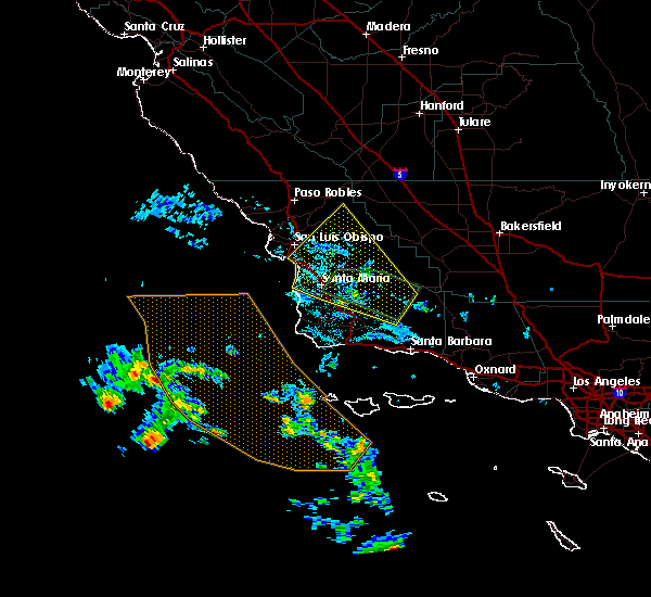
| 9/10/2017 7:57 PM PDT |
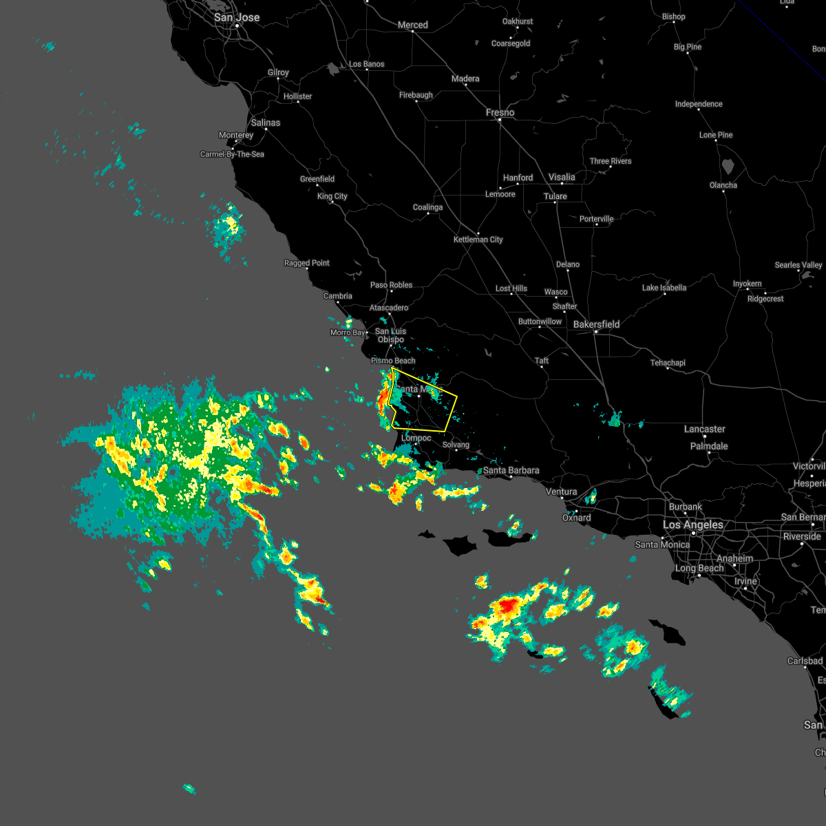 The severe thunderstorm warning for northwestern santa barbara and south central san luis obispo counties will expire at 800 pm pdt, the storm which prompted the warning has moved out of the area. therefore the warning will be allowed to expire. The severe thunderstorm warning for northwestern santa barbara and south central san luis obispo counties will expire at 800 pm pdt, the storm which prompted the warning has moved out of the area. therefore the warning will be allowed to expire.
|
| 9/10/2017 7:19 PM PDT |
 At 718 pm pdt, a severe thunderstorm was located 7 miles north of los alamos, or 10 miles southeast of santa maria, moving west at 35 mph (radar indicated). Hazards include 70 mph wind gusts and nickel size hail. Expect considerable tree damage. Damage is likely to mobile homes, roofs, and outbuildings. At 718 pm pdt, a severe thunderstorm was located 7 miles north of los alamos, or 10 miles southeast of santa maria, moving west at 35 mph (radar indicated). Hazards include 70 mph wind gusts and nickel size hail. Expect considerable tree damage. Damage is likely to mobile homes, roofs, and outbuildings.
|
| 9/10/2017 4:41 PM PDT |
 At 433 pm pdt, the severe thunderstorm has broken off into two separate storms. one of the thunderstorms was heading towards santa maria while the other was over miranda pine mountain. besides heavy rain, nws doppler radar indicated dime size hail. expect damaging wind gusts to 60 mph with these storm cells (radar indicated). Hazards include 60 mph wind gusts and near penny size hail. Expect damage to roofs, siding, and trees. Locations impacted include, santa maria, pismo beach, san luis obispo, arroyo grande, sisquoc, figueroa mountain, highway 166 between twitchell dam and the cuyama valley, and carrizo plain. At 433 pm pdt, the severe thunderstorm has broken off into two separate storms. one of the thunderstorms was heading towards santa maria while the other was over miranda pine mountain. besides heavy rain, nws doppler radar indicated dime size hail. expect damaging wind gusts to 60 mph with these storm cells (radar indicated). Hazards include 60 mph wind gusts and near penny size hail. Expect damage to roofs, siding, and trees. Locations impacted include, santa maria, pismo beach, san luis obispo, arroyo grande, sisquoc, figueroa mountain, highway 166 between twitchell dam and the cuyama valley, and carrizo plain.
|
| 9/10/2017 4:00 PM PDT |
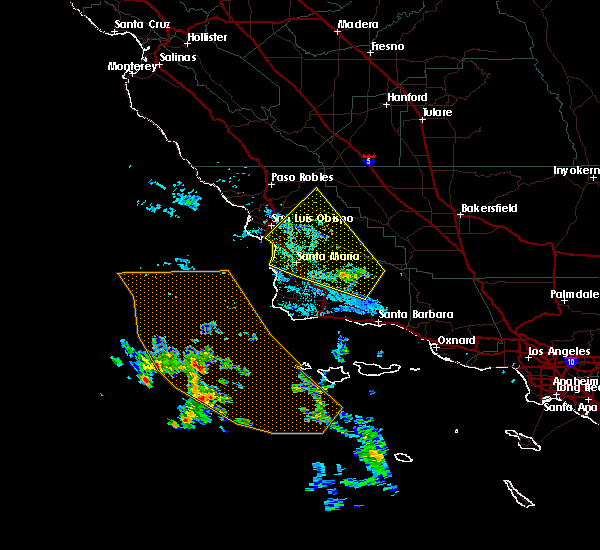 At 354 pm pdt, a severe thunderstorm was located near figueroa mountain, or 18 miles east of santa maria, moving northwest at 35 mph (radar indicated). Hazards include 60 mph wind gusts and penny size hail. expect damage to roofs, siding, and trees At 354 pm pdt, a severe thunderstorm was located near figueroa mountain, or 18 miles east of santa maria, moving northwest at 35 mph (radar indicated). Hazards include 60 mph wind gusts and penny size hail. expect damage to roofs, siding, and trees
|
Hail Maps for Grover Beach, CA

Connect with Interactive Hail Maps