

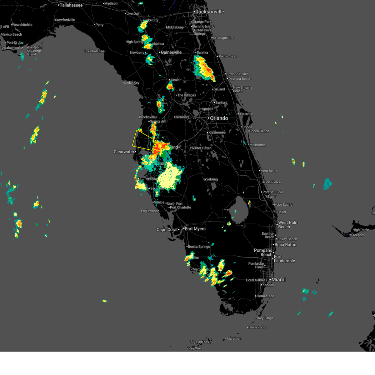
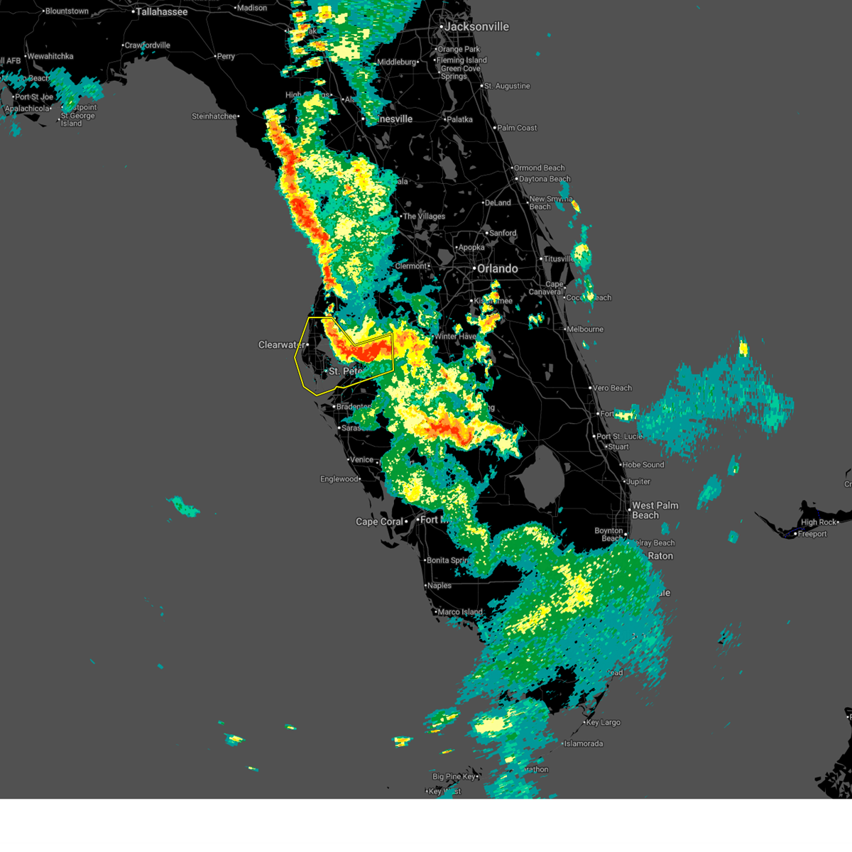
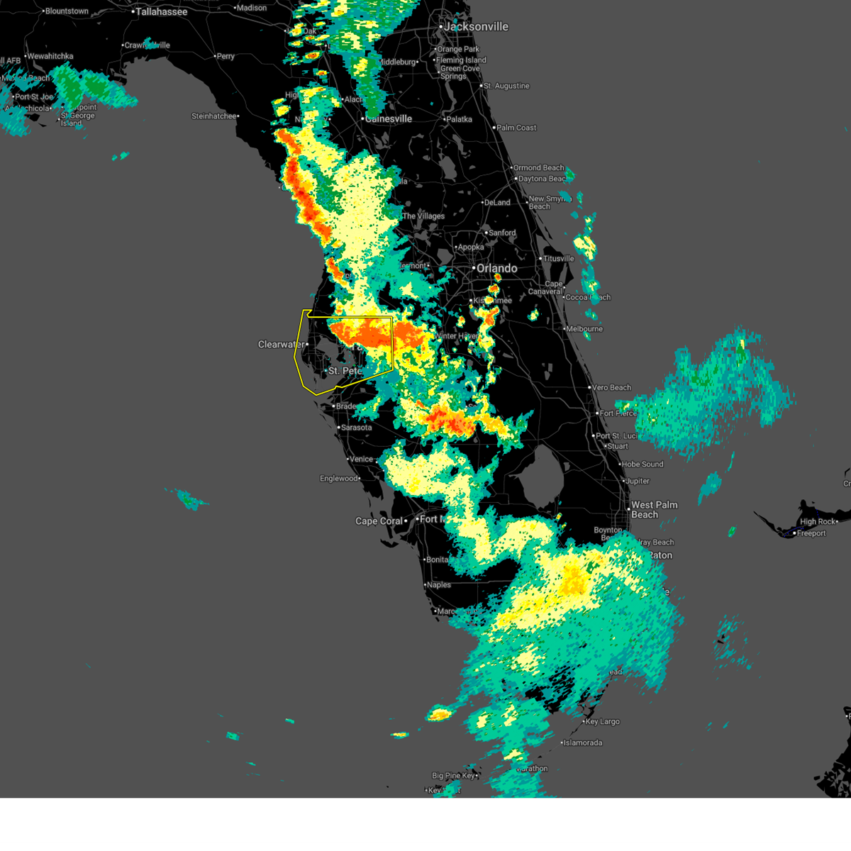
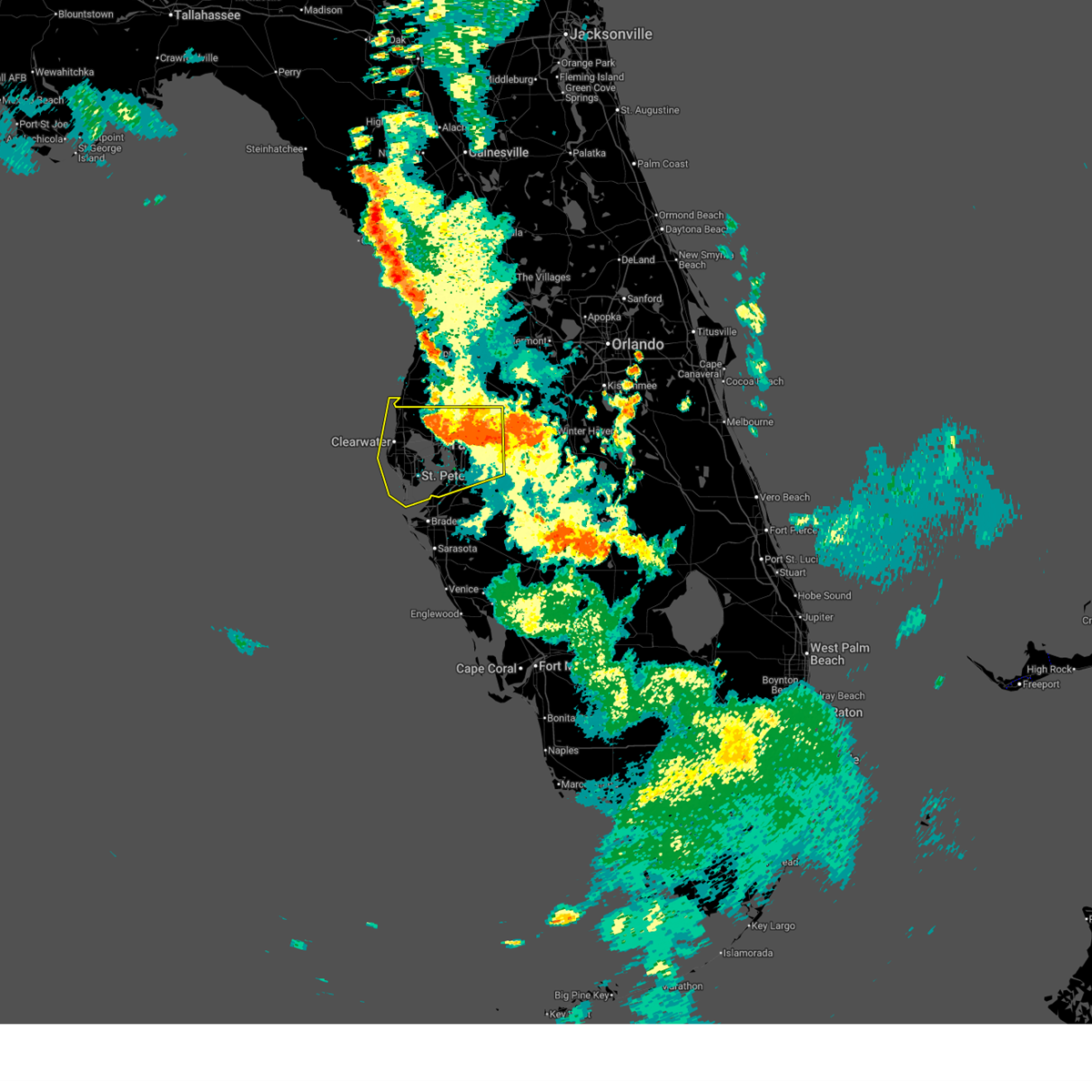
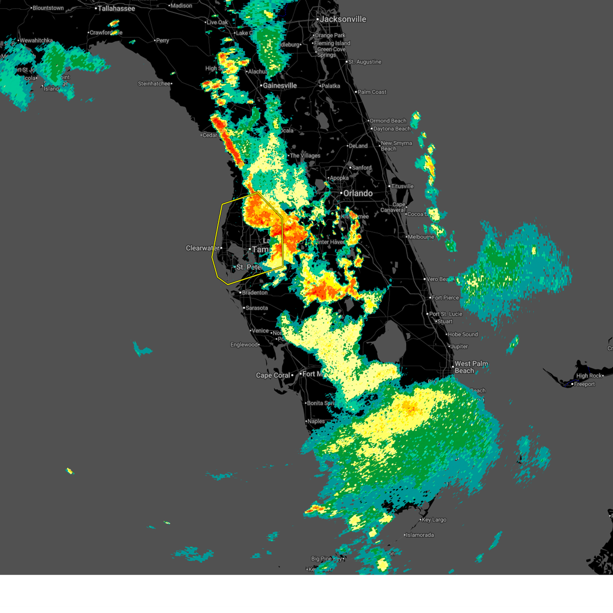
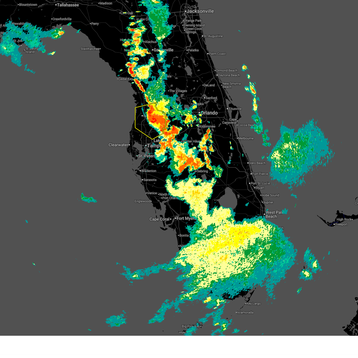
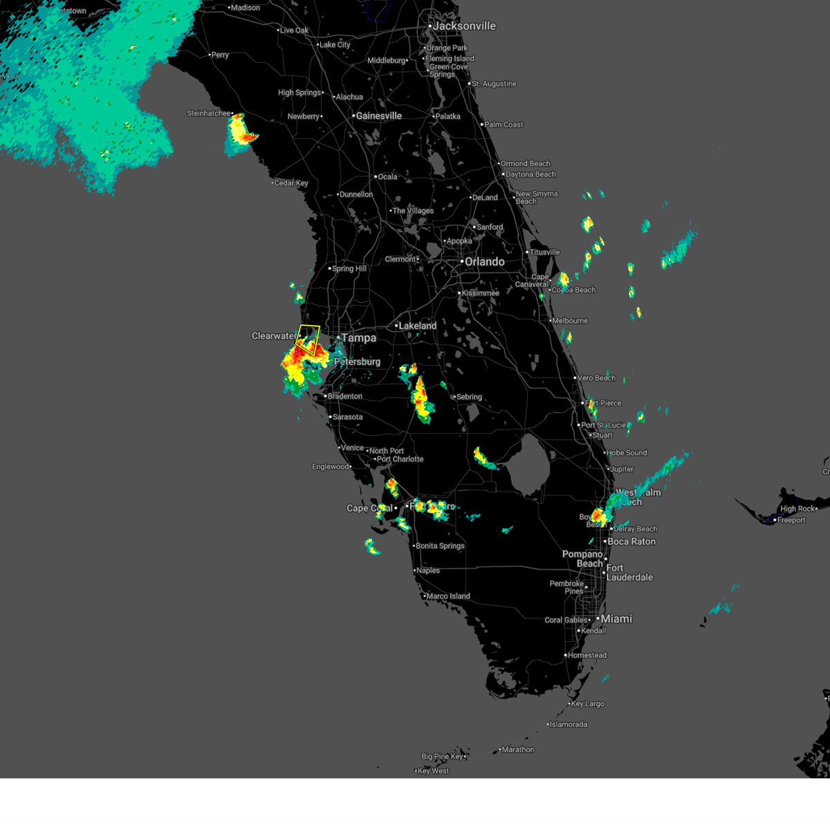
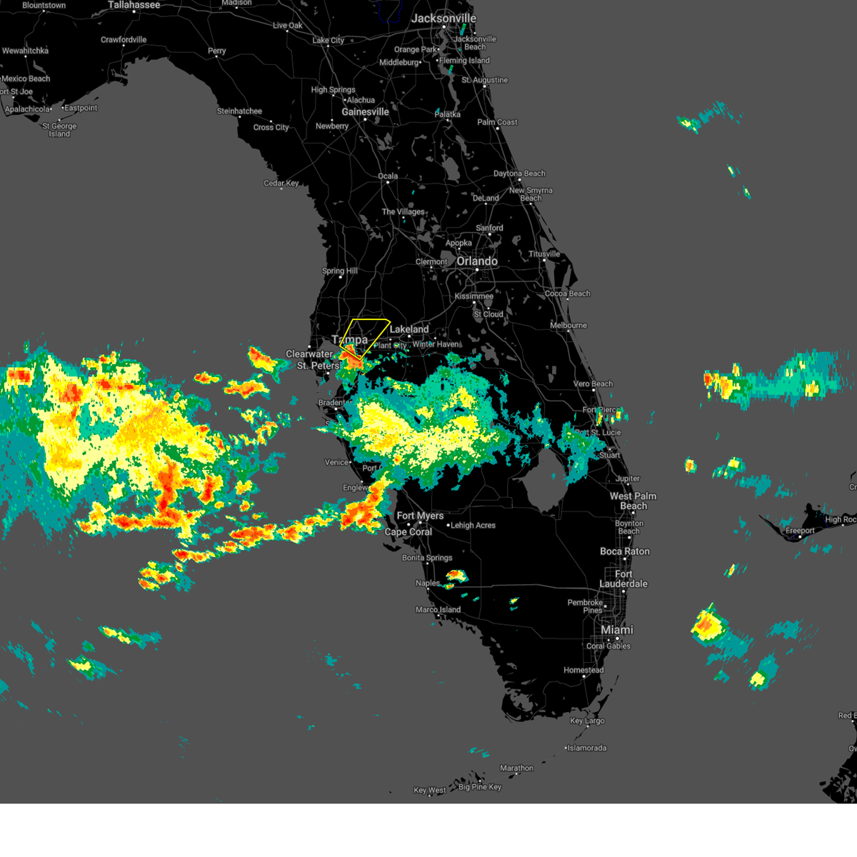
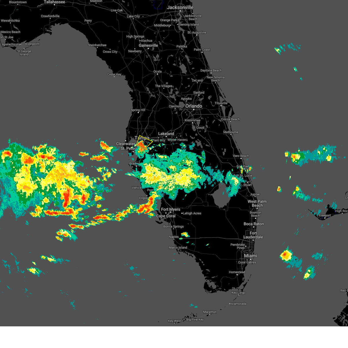
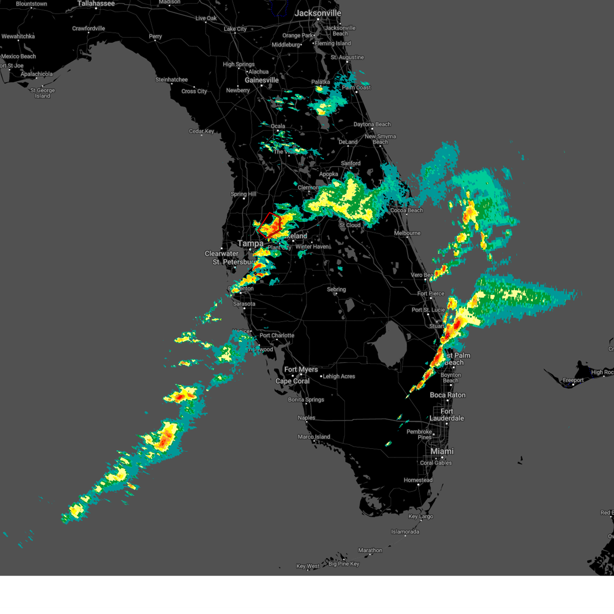
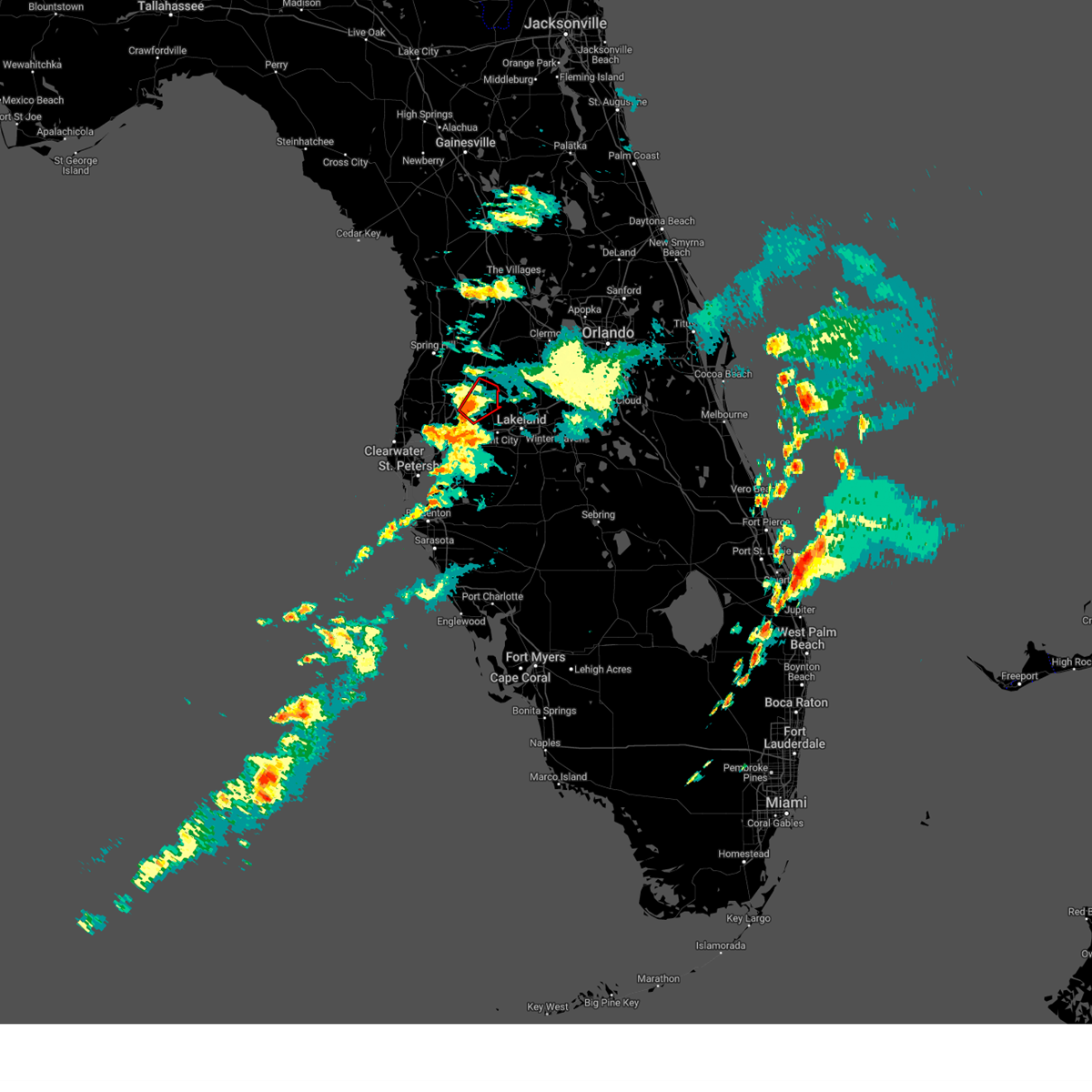
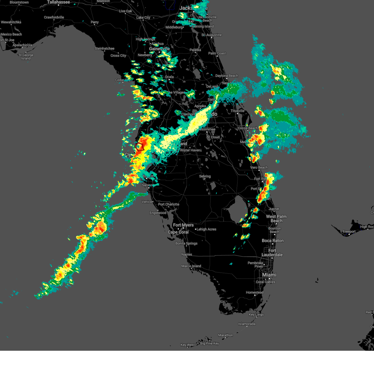
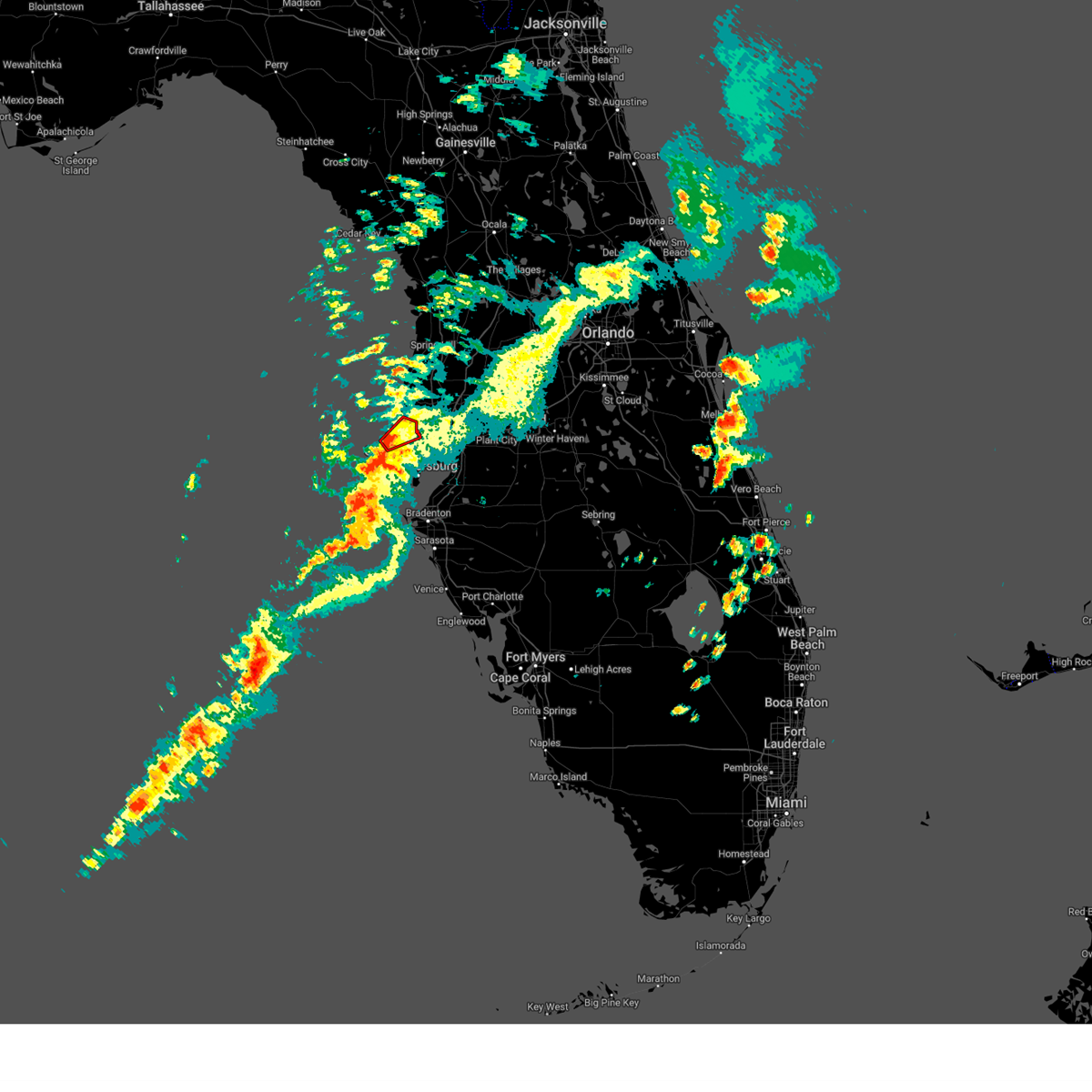
Hail Map for Tampa, FL
The Tampa, FL area has had 9 reports of on-the-ground hail by trained spotters, and has been under severe weather warnings 22 times during the past 12 months. Doppler radar has detected hail at or near Tampa, FL on 156 occasions, including 9 occasions during the past year.
| Name: | Tampa, FL |
| Where Located: | 36.3 miles N of Bradenton, FL |
| Map: | Google Map for Tampa, FL |
| Population: | 335709 |
| Housing Units: | 157130 |
| More Info: | Search Google for Tampa, FL |
3
The Top Recent Hail Date for Tampa, FL is Monday, June 2, 2025 (12th out of 156)

Hail and Wind Damage Spotted near Tampa, FL
| Date / Time | Report Details |
|---|---|
| 10/27/2025 4:54 PM EDT | The storms which prompted the warning have weakened below severe limits, and no longer pose an immediate threat to life or property. therefore, the warning will be allowed to expire. however, gusty winds and heavy rain are still possible with these thunderstorms. to report severe weather, contact your nearest law enforcement agency. they will relay your report to the national weather service ruskin. |
| 10/27/2025 4:15 PM EDT | Svrtbw the national weather service in ruskin has issued a * severe thunderstorm warning for, pasco county in west central florida, southwestern hernando county in west central florida, northern pinellas county in west central florida, northwestern hillsborough county in west central florida, * until 500 pm edt. * at 414 pm edt, severe thunderstorms were located along a line extending from 12 miles northwest of hudson to 10 miles northwest of beacon square to 17 miles west of palm harbor, moving east at 35 mph (radar indicated). Hazards include 60 mph wind gusts and penny size hail. expect damage to roofs, siding, and trees |
| 7/24/2025 7:07 PM EDT |
 Svrtbw the national weather service in ruskin has issued a * severe thunderstorm warning for, southwestern pasco county in west central florida, northwestern pinellas county in west central florida, northwestern hillsborough county in west central florida, * until 745 pm edt. * at 707 pm edt, a severe thunderstorm was located over greater northdale, or near lutz, moving northwest at 30 mph (radar indicated). Hazards include 60 mph wind gusts. expect damage to roofs, siding, and trees Svrtbw the national weather service in ruskin has issued a * severe thunderstorm warning for, southwestern pasco county in west central florida, northwestern pinellas county in west central florida, northwestern hillsborough county in west central florida, * until 745 pm edt. * at 707 pm edt, a severe thunderstorm was located over greater northdale, or near lutz, moving northwest at 30 mph (radar indicated). Hazards include 60 mph wind gusts. expect damage to roofs, siding, and trees
|
| 7/14/2025 6:33 PM EDT |
 At 633 pm edt, a severe thunderstorm was located over gandy, or near downtown saint petersburg, moving south at 40 mph (radar indicated). Hazards include 60 mph wind gusts. Expect damage to roofs, siding, and trees. locations impacted include, belleair bluffs, palm harbor, south tampa, sawgrass lake park, belleair beach, plant city airport, downtown saint petersburg, st. Pete beach, tampa international airport, and highpoint. At 633 pm edt, a severe thunderstorm was located over gandy, or near downtown saint petersburg, moving south at 40 mph (radar indicated). Hazards include 60 mph wind gusts. Expect damage to roofs, siding, and trees. locations impacted include, belleair bluffs, palm harbor, south tampa, sawgrass lake park, belleair beach, plant city airport, downtown saint petersburg, st. Pete beach, tampa international airport, and highpoint.
|
| 7/14/2025 6:19 PM EDT |
 the severe thunderstorm warning has been cancelled and is no longer in effect the severe thunderstorm warning has been cancelled and is no longer in effect
|
| 7/14/2025 6:19 PM EDT |
 At 619 pm edt, a severe thunderstorm was located over tampa international airport, or near tampa, moving south at 40 mph (radar indicated). Hazards include 60 mph wind gusts. Expect damage to roofs, siding, and trees. locations impacted include, belleair bluffs, palm harbor, south tampa, sawgrass lake park, belleair beach, plant city airport, tampa executive airport, downtown saint petersburg, st. Pete beach, and tampa international airport. At 619 pm edt, a severe thunderstorm was located over tampa international airport, or near tampa, moving south at 40 mph (radar indicated). Hazards include 60 mph wind gusts. Expect damage to roofs, siding, and trees. locations impacted include, belleair bluffs, palm harbor, south tampa, sawgrass lake park, belleair beach, plant city airport, tampa executive airport, downtown saint petersburg, st. Pete beach, and tampa international airport.
|
| 7/14/2025 5:56 PM EDT |
 Svrtbw the national weather service in ruskin has issued a * severe thunderstorm warning for, pasco county in west central florida, southwestern hernando county in west central florida, northwestern manatee county in west central florida, pinellas county in west central florida, western polk county in central florida, hillsborough county in west central florida, * until 645 pm edt. * at 556 pm edt, a severe thunderstorm was located over lutz, moving south at 40 mph (radar indicated). Hazards include 60 mph wind gusts. expect damage to roofs, siding, and trees Svrtbw the national weather service in ruskin has issued a * severe thunderstorm warning for, pasco county in west central florida, southwestern hernando county in west central florida, northwestern manatee county in west central florida, pinellas county in west central florida, western polk county in central florida, hillsborough county in west central florida, * until 645 pm edt. * at 556 pm edt, a severe thunderstorm was located over lutz, moving south at 40 mph (radar indicated). Hazards include 60 mph wind gusts. expect damage to roofs, siding, and trees
|
| 7/14/2025 5:35 PM EDT |
 At 534 pm edt, severe thunderstorms were located along a line extending from near north brooksville to 6 miles northwest of st. leo to zephyrhills north, moving east at 20 mph (radar indicated). Hazards include 60 mph wind gusts. Expect damage to roofs, siding, and trees. locations impacted include, saint leo, high point, lake lindsey, hillsborough river state park, shady hills, glen lakes, st. Leo, richland, south brooksville, and weeki wachee. At 534 pm edt, severe thunderstorms were located along a line extending from near north brooksville to 6 miles northwest of st. leo to zephyrhills north, moving east at 20 mph (radar indicated). Hazards include 60 mph wind gusts. Expect damage to roofs, siding, and trees. locations impacted include, saint leo, high point, lake lindsey, hillsborough river state park, shady hills, glen lakes, st. Leo, richland, south brooksville, and weeki wachee.
|
| 7/14/2025 5:35 PM EDT |
 the severe thunderstorm warning has been cancelled and is no longer in effect the severe thunderstorm warning has been cancelled and is no longer in effect
|
| 7/14/2025 5:25 PM EDT |
 Svrtbw the national weather service in ruskin has issued a * severe thunderstorm warning for, south central citrus county in west central florida, southern sumter county in central florida, pasco county in west central florida, hernando county in west central florida, northwestern polk county in central florida, north central hillsborough county in west central florida, * until 600 pm edt. * at 525 pm edt, severe thunderstorms were located along a line extending from north brooksville to near st. leo to near zephyrhills north, moving west at 20 mph (radar indicated). Hazards include 60 mph wind gusts. expect damage to roofs, siding, and trees Svrtbw the national weather service in ruskin has issued a * severe thunderstorm warning for, south central citrus county in west central florida, southern sumter county in central florida, pasco county in west central florida, hernando county in west central florida, northwestern polk county in central florida, north central hillsborough county in west central florida, * until 600 pm edt. * at 525 pm edt, severe thunderstorms were located along a line extending from north brooksville to near st. leo to near zephyrhills north, moving west at 20 mph (radar indicated). Hazards include 60 mph wind gusts. expect damage to roofs, siding, and trees
|
| 6/25/2025 7:41 PM EDT |
 Svrtbw the national weather service in ruskin has issued a * severe thunderstorm warning for, central pinellas county in west central florida, northwestern hillsborough county in west central florida, * until 830 pm edt. * at 740 pm edt, a severe thunderstorm was located over largo, moving northwest at 15 mph (radar indicated). Hazards include 60 mph wind gusts and half dollar size hail. Hail damage to vehicles is expected. Expect wind damage to roofs, siding, and trees. Svrtbw the national weather service in ruskin has issued a * severe thunderstorm warning for, central pinellas county in west central florida, northwestern hillsborough county in west central florida, * until 830 pm edt. * at 740 pm edt, a severe thunderstorm was located over largo, moving northwest at 15 mph (radar indicated). Hazards include 60 mph wind gusts and half dollar size hail. Hail damage to vehicles is expected. Expect wind damage to roofs, siding, and trees.
|
| 6/2/2025 11:12 AM EDT | Ping Pong Ball sized hail reported 8.2 miles W of Tampa, FL, report of 1.5-inch hail near intersection of i-4 and hwy 301. |
| 6/2/2025 11:10 AM EDT | Quarter sized hail reported 8.5 miles WNW of Tampa, FL, a few reports of quarter size hail near the florida state fairgrounds. |
| 6/2/2025 11:02 AM EDT |
 Svrtbw the national weather service in ruskin has issued a * severe thunderstorm warning for, northeastern hillsborough county in west central florida, * until 1130 am edt. * at 1102 am edt, a severe thunderstorm was located over east lake-orient park, or over tampa, moving northeast at 25 mph (radar indicated). Hazards include 60 mph wind gusts and penny size hail. expect damage to roofs, siding, and trees Svrtbw the national weather service in ruskin has issued a * severe thunderstorm warning for, northeastern hillsborough county in west central florida, * until 1130 am edt. * at 1102 am edt, a severe thunderstorm was located over east lake-orient park, or over tampa, moving northeast at 25 mph (radar indicated). Hazards include 60 mph wind gusts and penny size hail. expect damage to roofs, siding, and trees
|
| 6/2/2025 10:56 AM EDT | Report from davis island yacht clu in hillsborough county FL, 7.8 miles NNW of Tampa, FL |
| 6/2/2025 10:49 AM EDT |
 Svrtbw the national weather service in ruskin has issued a * severe thunderstorm warning for, central hillsborough county in west central florida, * until 1115 am edt. * at 1049 am edt, severe thunderstorms were located along a line extending from near tampa international airport to near palm river-clair mel, moving northeast at 15 mph (radar indicated). Hazards include 60 mph wind gusts and penny size hail. expect damage to roofs, siding, and trees Svrtbw the national weather service in ruskin has issued a * severe thunderstorm warning for, central hillsborough county in west central florida, * until 1115 am edt. * at 1049 am edt, severe thunderstorms were located along a line extending from near tampa international airport to near palm river-clair mel, moving northeast at 15 mph (radar indicated). Hazards include 60 mph wind gusts and penny size hail. expect damage to roofs, siding, and trees
|
| 5/31/2025 7:31 AM EDT |
 the severe thunderstorm warning has been cancelled and is no longer in effect the severe thunderstorm warning has been cancelled and is no longer in effect
|
| 5/31/2025 7:29 AM EDT |
 At 729 am edt, a severe thunderstorm was located over west and east lealman, or near saint petersburg, moving east at 20 mph (radar indicated). Hazards include 60 mph wind gusts. Expect damage to roofs, siding, and trees. locations impacted include, gulfport, bay pines, tropicana field, sawgrass lake park, vinoy park, pass-a-grille beach, lake maggiore, boyd hill nature preserve, downtown saint petersburg, and st. Pete beach. At 729 am edt, a severe thunderstorm was located over west and east lealman, or near saint petersburg, moving east at 20 mph (radar indicated). Hazards include 60 mph wind gusts. Expect damage to roofs, siding, and trees. locations impacted include, gulfport, bay pines, tropicana field, sawgrass lake park, vinoy park, pass-a-grille beach, lake maggiore, boyd hill nature preserve, downtown saint petersburg, and st. Pete beach.
|
| 5/31/2025 7:17 AM EDT |
 At 717 am edt, a severe thunderstorm was located over bay pines, or near seminole, moving southeast at 20 mph (radar indicated). Hazards include 60 mph wind gusts. Expect damage to roofs, siding, and trees. Locations impacted include, gulfport, bay pines, south highpoint, tropicana field, sawgrass lake park, redington shores, vinoy park, pass-a-grille beach, lake maggiore, and boyd hill nature preserve. At 717 am edt, a severe thunderstorm was located over bay pines, or near seminole, moving southeast at 20 mph (radar indicated). Hazards include 60 mph wind gusts. Expect damage to roofs, siding, and trees. Locations impacted include, gulfport, bay pines, south highpoint, tropicana field, sawgrass lake park, redington shores, vinoy park, pass-a-grille beach, lake maggiore, and boyd hill nature preserve.
|
| 5/31/2025 7:08 AM EDT |
 Svrtbw the national weather service in ruskin has issued a * severe thunderstorm warning for, central pinellas county in west central florida, * until 745 am edt. * at 708 am edt, a severe thunderstorm was located over seminole, moving southeast at 20 mph (radar indicated). Hazards include 60 mph wind gusts. expect damage to roofs, siding, and trees Svrtbw the national weather service in ruskin has issued a * severe thunderstorm warning for, central pinellas county in west central florida, * until 745 am edt. * at 708 am edt, a severe thunderstorm was located over seminole, moving southeast at 20 mph (radar indicated). Hazards include 60 mph wind gusts. expect damage to roofs, siding, and trees
|
| 3/16/2025 7:16 PM EDT |
 the tornado warning has been cancelled and is no longer in effect the tornado warning has been cancelled and is no longer in effect
|
| 3/16/2025 7:00 PM EDT |
 Tortbw the national weather service in ruskin has issued a * tornado warning for, southeastern pasco county in west central florida, north central hillsborough county in west central florida, * until 730 pm edt. * at 659 pm edt, a severe thunderstorm capable of producing a tornado was located over hillsborough river state park, or 8 miles southwest of zephyrhills, moving northeast at 25 mph (radar indicated rotation). Hazards include tornado. Flying debris will be dangerous to those caught without shelter. mobile homes will be damaged or destroyed. damage to roofs, windows, and vehicles will occur. tree damage is likely. this dangerous storm will be near, wesley chapel south, hillsborough river state park, zephyrhills west, zephyrhills south, zephyrhills north, and zephyrhills around 705 pm edt. Other locations impacted by this tornadic thunderstorm include crystal springs, richland, zephyrhills municipal airport, meadow pointe, wesley chapel, and thonotosassa. Tortbw the national weather service in ruskin has issued a * tornado warning for, southeastern pasco county in west central florida, north central hillsborough county in west central florida, * until 730 pm edt. * at 659 pm edt, a severe thunderstorm capable of producing a tornado was located over hillsborough river state park, or 8 miles southwest of zephyrhills, moving northeast at 25 mph (radar indicated rotation). Hazards include tornado. Flying debris will be dangerous to those caught without shelter. mobile homes will be damaged or destroyed. damage to roofs, windows, and vehicles will occur. tree damage is likely. this dangerous storm will be near, wesley chapel south, hillsborough river state park, zephyrhills west, zephyrhills south, zephyrhills north, and zephyrhills around 705 pm edt. Other locations impacted by this tornadic thunderstorm include crystal springs, richland, zephyrhills municipal airport, meadow pointe, wesley chapel, and thonotosassa.
|
| 3/16/2025 5:58 PM EDT |
 The storm which prompted the warning has weakened below severe limits, and no longer appears capable of producing a tornado. therefore, the warning will be allowed to expire. however, gusty winds are still possible with this thunderstorm. to report severe weather, contact your nearest law enforcement agency. they will relay your report to the national weather service ruskin. The storm which prompted the warning has weakened below severe limits, and no longer appears capable of producing a tornado. therefore, the warning will be allowed to expire. however, gusty winds are still possible with this thunderstorm. to report severe weather, contact your nearest law enforcement agency. they will relay your report to the national weather service ruskin.
|
| 3/16/2025 5:50 PM EDT |
 At 549 pm edt, a severe thunderstorm capable of producing a tornado was located near palm harbor, moving northeast at 25 mph (radar indicated rotation). Hazards include tornado. Flying debris will be dangerous to those caught without shelter. mobile homes will be damaged or destroyed. damage to roofs, windows, and vehicles will occur. tree damage is likely. this dangerous storm will be near, east lake around 555 pm edt. Other locations impacted by this tornadic thunderstorm include oldsmar and safety harbor. At 549 pm edt, a severe thunderstorm capable of producing a tornado was located near palm harbor, moving northeast at 25 mph (radar indicated rotation). Hazards include tornado. Flying debris will be dangerous to those caught without shelter. mobile homes will be damaged or destroyed. damage to roofs, windows, and vehicles will occur. tree damage is likely. this dangerous storm will be near, east lake around 555 pm edt. Other locations impacted by this tornadic thunderstorm include oldsmar and safety harbor.
|
| 3/16/2025 5:30 PM EDT |
 Tortbw the national weather service in ruskin has issued a * tornado warning for, northwestern pinellas county in west central florida, * until 600 pm edt. * at 529 pm edt, a severe thunderstorm capable of producing a tornado was located near clearwater, moving northeast at 25 mph (radar indicated rotation). Hazards include tornado. Flying debris will be dangerous to those caught without shelter. mobile homes will be damaged or destroyed. damage to roofs, windows, and vehicles will occur. tree damage is likely. this dangerous storm will be near, east lake, clearwater, palm harbor, and tampa around 535 pm edt. Other locations impacted by this tornadic thunderstorm include belleair bluffs, belleair shore, belleair, belleair beach, oldsmar, safety harbor, and caladesi island. Tortbw the national weather service in ruskin has issued a * tornado warning for, northwestern pinellas county in west central florida, * until 600 pm edt. * at 529 pm edt, a severe thunderstorm capable of producing a tornado was located near clearwater, moving northeast at 25 mph (radar indicated rotation). Hazards include tornado. Flying debris will be dangerous to those caught without shelter. mobile homes will be damaged or destroyed. damage to roofs, windows, and vehicles will occur. tree damage is likely. this dangerous storm will be near, east lake, clearwater, palm harbor, and tampa around 535 pm edt. Other locations impacted by this tornadic thunderstorm include belleair bluffs, belleair shore, belleair, belleair beach, oldsmar, safety harbor, and caladesi island.
|
| 7/14/2024 4:55 PM EDT |
 Svrtbw the national weather service in ruskin has issued a * severe thunderstorm warning for, central hillsborough county in west central florida, * until 515 pm edt. * at 455 pm edt, a severe thunderstorm was located over palm river-clair mel, or near brandon, and is nearly stationary (radar indicated). Hazards include 60 mph wind gusts and penny size hail. expect damage to roofs, siding, and trees Svrtbw the national weather service in ruskin has issued a * severe thunderstorm warning for, central hillsborough county in west central florida, * until 515 pm edt. * at 455 pm edt, a severe thunderstorm was located over palm river-clair mel, or near brandon, and is nearly stationary (radar indicated). Hazards include 60 mph wind gusts and penny size hail. expect damage to roofs, siding, and trees
|
| 6/16/2024 8:26 PM EDT |
 the severe thunderstorm warning has been cancelled and is no longer in effect the severe thunderstorm warning has been cancelled and is no longer in effect
|
| 6/16/2024 8:07 PM EDT |
 Svrtbw the national weather service in ruskin has issued a * severe thunderstorm warning for, central pinellas county in west central florida, southwestern hillsborough county in west central florida, * until 845 pm edt. * at 807 pm edt, a severe thunderstorm was located over gandy, or near downtown saint petersburg, moving west at 10 mph (radar indicated). Hazards include 60 mph wind gusts. expect damage to roofs, siding, and trees Svrtbw the national weather service in ruskin has issued a * severe thunderstorm warning for, central pinellas county in west central florida, southwestern hillsborough county in west central florida, * until 845 pm edt. * at 807 pm edt, a severe thunderstorm was located over gandy, or near downtown saint petersburg, moving west at 10 mph (radar indicated). Hazards include 60 mph wind gusts. expect damage to roofs, siding, and trees
|
| 5/14/2024 11:40 AM EDT | Mesonet station 1829w fswn tampa international airpor in hillsborough county FL, 3.4 miles NE of Tampa, FL |
| 5/14/2024 11:37 AM EDT |
 At 1137 am edt, a severe thunderstorm was located over citrus park, or near tampa, moving east at 45 mph (radar indicated). Hazards include 60 mph wind gusts and quarter size hail. Hail damage to vehicles is expected. expect wind damage to roofs, siding, and trees. Locations impacted include, tampa, clearwater, largo, temple terrace, safety harbor, west park, oldsmar, busch gardens, south highpoint, and trinity. At 1137 am edt, a severe thunderstorm was located over citrus park, or near tampa, moving east at 45 mph (radar indicated). Hazards include 60 mph wind gusts and quarter size hail. Hail damage to vehicles is expected. expect wind damage to roofs, siding, and trees. Locations impacted include, tampa, clearwater, largo, temple terrace, safety harbor, west park, oldsmar, busch gardens, south highpoint, and trinity.
|
| 5/14/2024 11:07 AM EDT |
 Svrtbw the national weather service in ruskin has issued a * severe thunderstorm warning for, southwestern pasco county in west central florida, northern pinellas county in west central florida, northwestern hillsborough county in west central florida, * until 1145 am edt. * at 1106 am edt, a severe thunderstorm was located 9 miles northwest of harbor bluffs, or 11 miles northwest of largo, moving east at 45 mph (radar indicated). Hazards include 60 mph wind gusts and quarter size hail. Hail damage to vehicles is expected. Expect wind damage to roofs, siding, and trees. Svrtbw the national weather service in ruskin has issued a * severe thunderstorm warning for, southwestern pasco county in west central florida, northern pinellas county in west central florida, northwestern hillsborough county in west central florida, * until 1145 am edt. * at 1106 am edt, a severe thunderstorm was located 9 miles northwest of harbor bluffs, or 11 miles northwest of largo, moving east at 45 mph (radar indicated). Hazards include 60 mph wind gusts and quarter size hail. Hail damage to vehicles is expected. Expect wind damage to roofs, siding, and trees.
|
| 4/11/2024 1:16 PM EDT |
 Svrtbw the national weather service in ruskin has issued a * severe thunderstorm warning for, southeastern pasco county in west central florida, manatee county in west central florida, southeastern pinellas county in west central florida, northwestern polk county in central florida, hillsborough county in west central florida, * until 200 pm edt. * at 116 pm edt, severe thunderstorms were located along a line extending from near temple terrace to 12 miles southwest of anna maria, moving east at 40 mph (radar indicated). Hazards include 60 mph wind gusts. expect damage to roofs, siding, and trees Svrtbw the national weather service in ruskin has issued a * severe thunderstorm warning for, southeastern pasco county in west central florida, manatee county in west central florida, southeastern pinellas county in west central florida, northwestern polk county in central florida, hillsborough county in west central florida, * until 200 pm edt. * at 116 pm edt, severe thunderstorms were located along a line extending from near temple terrace to 12 miles southwest of anna maria, moving east at 40 mph (radar indicated). Hazards include 60 mph wind gusts. expect damage to roofs, siding, and trees
|
| 4/11/2024 1:06 PM EDT |
 The tornado threat has diminished and the tornado warning has been cancelled. however, damaging winds remain likely and a severe thunderstorm warning remains in effect for the area. a tornado watch remains in effect until 300 pm edt for west central florida. The tornado threat has diminished and the tornado warning has been cancelled. however, damaging winds remain likely and a severe thunderstorm warning remains in effect for the area. a tornado watch remains in effect until 300 pm edt for west central florida.
|
| 4/11/2024 1:04 PM EDT |
 At 104 pm edt, severe thunderstorms were located along a line extending from 7 miles southwest of bushnell to near pebble creek to near fort desoto park, moving east at 45 mph (radar indicated). Hazards include 60 mph wind gusts. Expect damage to roofs, siding, and trees. locations impacted include, tampa, st. petersburg, bradenton, plant city, temple terrace, zephyrhills, palmetto, gulfport, st. Pete beach, and wildwood. At 104 pm edt, severe thunderstorms were located along a line extending from 7 miles southwest of bushnell to near pebble creek to near fort desoto park, moving east at 45 mph (radar indicated). Hazards include 60 mph wind gusts. Expect damage to roofs, siding, and trees. locations impacted include, tampa, st. petersburg, bradenton, plant city, temple terrace, zephyrhills, palmetto, gulfport, st. Pete beach, and wildwood.
|
| 4/11/2024 1:00 PM EDT | Mesonet station 1829w fswn tampa international airpor in hillsborough county FL, 3.4 miles NE of Tampa, FL |
| 4/11/2024 12:56 PM EDT |
 Tortbw the national weather service in ruskin has issued a * tornado warning for, north central hillsborough county in west central florida, * until 115 pm edt. * at 1256 pm edt, a confirmed waterspout was located just offshore tampa international airport, or near tampa, moving northeast at 35 mph (weather spotters confirmed waterspout moving onshore). Hazards include tornado. Flying debris will be dangerous to those caught without shelter. mobile homes will be damaged or destroyed. damage to roofs, windows, and vehicles will occur. tree damage is likely. this tornado will be near, tampa, temple terrace, lutz, greater carrollwood, egypt lake-leto, university, and lake magdalene around 100 pm edt. Other locations impacted by this tornado include busch gardens, raymond james stadium, carrollwood, university of south florida, and west park. Tortbw the national weather service in ruskin has issued a * tornado warning for, north central hillsborough county in west central florida, * until 115 pm edt. * at 1256 pm edt, a confirmed waterspout was located just offshore tampa international airport, or near tampa, moving northeast at 35 mph (weather spotters confirmed waterspout moving onshore). Hazards include tornado. Flying debris will be dangerous to those caught without shelter. mobile homes will be damaged or destroyed. damage to roofs, windows, and vehicles will occur. tree damage is likely. this tornado will be near, tampa, temple terrace, lutz, greater carrollwood, egypt lake-leto, university, and lake magdalene around 100 pm edt. Other locations impacted by this tornado include busch gardens, raymond james stadium, carrollwood, university of south florida, and west park.
|
| 4/11/2024 12:48 PM EDT |
 Tortbw the national weather service in ruskin has issued a * tornado warning for, northwestern hillsborough county in west central florida, * until 100 pm edt. * at 1247 pm edt, a radar indicated waterspout was located just offshore near feather sound, or 7 miles east of clearwater, moving northeast at 40 mph (radar indicated rotation). Hazards include tornado. Flying debris will be dangerous to those caught without shelter. mobile homes will be damaged or destroyed. damage to roofs, windows, and vehicles will occur. tree damage is likely. this tornado will be near, tampa, egypt lake-leto, and citrus park around 1255 pm edt. Other locations impacted by this tornadic thunderstorm include carrollwood, town n country, west park, and westchase. Tortbw the national weather service in ruskin has issued a * tornado warning for, northwestern hillsborough county in west central florida, * until 100 pm edt. * at 1247 pm edt, a radar indicated waterspout was located just offshore near feather sound, or 7 miles east of clearwater, moving northeast at 40 mph (radar indicated rotation). Hazards include tornado. Flying debris will be dangerous to those caught without shelter. mobile homes will be damaged or destroyed. damage to roofs, windows, and vehicles will occur. tree damage is likely. this tornado will be near, tampa, egypt lake-leto, and citrus park around 1255 pm edt. Other locations impacted by this tornadic thunderstorm include carrollwood, town n country, west park, and westchase.
|
| 4/11/2024 12:37 PM EDT |
 The tornado threat has diminished and the tornado warning has been cancelled. however, damaging winds remain likely and a severe thunderstorm warning remains in effect for the area. a tornado watch remains in effect until 300 pm edt for west central florida. The tornado threat has diminished and the tornado warning has been cancelled. however, damaging winds remain likely and a severe thunderstorm warning remains in effect for the area. a tornado watch remains in effect until 300 pm edt for west central florida.
|
| 4/11/2024 12:30 PM EDT |
 Svrtbw the national weather service in ruskin has issued a * severe thunderstorm warning for, southeastern citrus county in west central florida, sumter county in central florida, pasco county in west central florida, hernando county in west central florida, northwestern manatee county in west central florida, pinellas county in west central florida, northwestern polk county in central florida, hillsborough county in west central florida, * until 115 pm edt. * at 1229 pm edt, severe thunderstorms were located along a line extending from near spring hill to 6 miles southwest of citrus park to 17 miles west of anna maria, moving east at 45 mph (radar indicated). Hazards include 60 mph wind gusts. expect damage to roofs, siding, and trees Svrtbw the national weather service in ruskin has issued a * severe thunderstorm warning for, southeastern citrus county in west central florida, sumter county in central florida, pasco county in west central florida, hernando county in west central florida, northwestern manatee county in west central florida, pinellas county in west central florida, northwestern polk county in central florida, hillsborough county in west central florida, * until 115 pm edt. * at 1229 pm edt, severe thunderstorms were located along a line extending from near spring hill to 6 miles southwest of citrus park to 17 miles west of anna maria, moving east at 45 mph (radar indicated). Hazards include 60 mph wind gusts. expect damage to roofs, siding, and trees
|
| 4/11/2024 12:16 PM EDT |
 Tortbw the national weather service in ruskin has issued a * tornado warning for, northwestern pinellas county in west central florida, * until 1245 pm edt. * at 1215 pm edt, a severe thunderstorm capable of producing a tornado was located near harbor bluffs, or 7 miles northwest of seminole, moving northeast at 35 mph (radar indicated rotation). Hazards include tornado. Flying debris will be dangerous to those caught without shelter. mobile homes will be damaged or destroyed. damage to roofs, windows, and vehicles will occur. tree damage is likely. this dangerous storm will be near, clearwater, largo, harbor bluffs, and ridgecrest around 1220 pm edt. palm harbor around 1225 pm edt. east lake around 1230 pm edt. Other locations impacted by this tornadic thunderstorm include belleair bluffs, indian shores, walsingham park, belleair shore, crystal beach, belleair, belleair shores, belleair beach, oldsmar, and safety harbor. Tortbw the national weather service in ruskin has issued a * tornado warning for, northwestern pinellas county in west central florida, * until 1245 pm edt. * at 1215 pm edt, a severe thunderstorm capable of producing a tornado was located near harbor bluffs, or 7 miles northwest of seminole, moving northeast at 35 mph (radar indicated rotation). Hazards include tornado. Flying debris will be dangerous to those caught without shelter. mobile homes will be damaged or destroyed. damage to roofs, windows, and vehicles will occur. tree damage is likely. this dangerous storm will be near, clearwater, largo, harbor bluffs, and ridgecrest around 1220 pm edt. palm harbor around 1225 pm edt. east lake around 1230 pm edt. Other locations impacted by this tornadic thunderstorm include belleair bluffs, indian shores, walsingham park, belleair shore, crystal beach, belleair, belleair shores, belleair beach, oldsmar, and safety harbor.
|
| 4/11/2024 11:47 AM EDT |
 Svrtbw the national weather service in ruskin has issued a * severe thunderstorm warning for, southern citrus county in west central florida, northwestern sumter county in central florida, pasco county in west central florida, hernando county in west central florida, pinellas county in west central florida, northwestern hillsborough county in west central florida, * until 1230 pm edt. * at 1146 am edt, severe thunderstorms were located along a line extending from 6 miles northwest of pine island to near hudson to near clearwater to 19 miles southwest of harbor bluffs, moving northeast at 50 mph (radar indicated). Hazards include 60 mph wind gusts. expect damage to roofs, siding, and trees Svrtbw the national weather service in ruskin has issued a * severe thunderstorm warning for, southern citrus county in west central florida, northwestern sumter county in central florida, pasco county in west central florida, hernando county in west central florida, pinellas county in west central florida, northwestern hillsborough county in west central florida, * until 1230 pm edt. * at 1146 am edt, severe thunderstorms were located along a line extending from 6 miles northwest of pine island to near hudson to near clearwater to 19 miles southwest of harbor bluffs, moving northeast at 50 mph (radar indicated). Hazards include 60 mph wind gusts. expect damage to roofs, siding, and trees
|
| 4/3/2024 2:42 PM EDT |
 The storm which prompted the warning has weakened below severe limits, and no longer poses an immediate threat to life or property. therefore, the warning will be allowed to expire. The storm which prompted the warning has weakened below severe limits, and no longer poses an immediate threat to life or property. therefore, the warning will be allowed to expire.
|
| 4/3/2024 2:32 PM EDT |
 At 232 pm edt, a severe thunderstorm was located over greater northdale, or near lutz, moving east at 40 mph (radar indicated). Hazards include 60 mph wind gusts. Expect damage to roofs, siding, and trees. Locations impacted include, tampa, temple terrace, west park, busch gardens, egypt lake-leto, pebble creek, carrollwood, citrus park, greater carrollwood, and lutz. At 232 pm edt, a severe thunderstorm was located over greater northdale, or near lutz, moving east at 40 mph (radar indicated). Hazards include 60 mph wind gusts. Expect damage to roofs, siding, and trees. Locations impacted include, tampa, temple terrace, west park, busch gardens, egypt lake-leto, pebble creek, carrollwood, citrus park, greater carrollwood, and lutz.
|
| 4/3/2024 2:32 PM EDT |
 the severe thunderstorm warning has been cancelled and is no longer in effect the severe thunderstorm warning has been cancelled and is no longer in effect
|
| 4/3/2024 2:21 PM EDT |
 At 221 pm edt, a severe thunderstorm was located near east lake, or 9 miles northeast of clearwater, moving east at 40 mph (radar indicated). Hazards include 60 mph wind gusts. Expect damage to roofs, siding, and trees. Locations impacted include, tampa, clearwater, temple terrace, safety harbor, west park, oldsmar, busch gardens, mango, lutz, and new tampa. At 221 pm edt, a severe thunderstorm was located near east lake, or 9 miles northeast of clearwater, moving east at 40 mph (radar indicated). Hazards include 60 mph wind gusts. Expect damage to roofs, siding, and trees. Locations impacted include, tampa, clearwater, temple terrace, safety harbor, west park, oldsmar, busch gardens, mango, lutz, and new tampa.
|
| 4/3/2024 2:14 PM EDT |
 Svrtbw the national weather service in ruskin has issued a * severe thunderstorm warning for, northeastern pinellas county in west central florida, northwestern hillsborough county in west central florida, * until 245 pm edt. * at 214 pm edt, a severe thunderstorm was located over palm harbor, or near clearwater, moving east at 40 mph (radar indicated). Hazards include 60 mph wind gusts. expect damage to roofs, siding, and trees Svrtbw the national weather service in ruskin has issued a * severe thunderstorm warning for, northeastern pinellas county in west central florida, northwestern hillsborough county in west central florida, * until 245 pm edt. * at 214 pm edt, a severe thunderstorm was located over palm harbor, or near clearwater, moving east at 40 mph (radar indicated). Hazards include 60 mph wind gusts. expect damage to roofs, siding, and trees
|
| 1/9/2024 4:55 PM EST | Awos station kmcf macdill afb tam in hillsborough county FL, 11.6 miles N of Tampa, FL |
| 1/9/2024 4:31 PM EST |
 The national weather service in ruskin has issued a * tornado warning for. central hillsborough county in west central florida. until 445 pm est. At 431 pm est, a severe thunderstorm capable of producing a tornado was located over macdill air force base, or 8 miles south of tampa,. The national weather service in ruskin has issued a * tornado warning for. central hillsborough county in west central florida. until 445 pm est. At 431 pm est, a severe thunderstorm capable of producing a tornado was located over macdill air force base, or 8 miles south of tampa,.
|
| 1/9/2024 4:22 PM EST |
 At 422 pm est, a severe thunderstorm capable of producing a tornado was located over saint petersburg, moving northeast at 45 mph (radar indicated rotation). Hazards include tornado. Flying debris will be dangerous to those caught without shelter. mobile homes will be damaged or destroyed. damage to roofs, windows, and vehicles will occur. tree damage is likely. this dangerous storm will be near, downtown saint petersburg and st. petersburg around 425 pm est. Other locations impacted by this tornadic thunderstorm include vinoy park, albert whitted airport, lake maggiore, tropicana field, boyd hill nature preserve, venetian isles, crescent lake, snell isle, and gulfport. At 422 pm est, a severe thunderstorm capable of producing a tornado was located over saint petersburg, moving northeast at 45 mph (radar indicated rotation). Hazards include tornado. Flying debris will be dangerous to those caught without shelter. mobile homes will be damaged or destroyed. damage to roofs, windows, and vehicles will occur. tree damage is likely. this dangerous storm will be near, downtown saint petersburg and st. petersburg around 425 pm est. Other locations impacted by this tornadic thunderstorm include vinoy park, albert whitted airport, lake maggiore, tropicana field, boyd hill nature preserve, venetian isles, crescent lake, snell isle, and gulfport.
|
| 1/9/2024 4:10 PM EST |
 The national weather service in ruskin has issued a * tornado warning for. central pinellas county in west central florida. central hillsborough county in west central florida. until 430 pm est. At 410 pm est, a severe thunderstorm capable of producing a tornado. The national weather service in ruskin has issued a * tornado warning for. central pinellas county in west central florida. central hillsborough county in west central florida. until 430 pm est. At 410 pm est, a severe thunderstorm capable of producing a tornado.
|
| 1/9/2024 3:54 PM EST |
 At 354 pm est, a severe thunderstorm was located near seminole, moving east at 40 mph (radar indicated). Hazards include 60 mph wind gusts. expect damage to roofs, siding, and trees At 354 pm est, a severe thunderstorm was located near seminole, moving east at 40 mph (radar indicated). Hazards include 60 mph wind gusts. expect damage to roofs, siding, and trees
|
| 10/12/2023 11:52 AM EDT |
 The tornado warning for southwestern pasco, northwestern pinellas and northwestern hillsborough counties will expire at noon edt, the storm which prompted the warning has weakened below severe limits, and no longer appears capable of producing a tornado. therefore, the warning will be allowed to expire. however, gusty winds are still possible with this thunderstorm. a tornado watch remains in effect until 300 pm edt for west central florida. The tornado warning for southwestern pasco, northwestern pinellas and northwestern hillsborough counties will expire at noon edt, the storm which prompted the warning has weakened below severe limits, and no longer appears capable of producing a tornado. therefore, the warning will be allowed to expire. however, gusty winds are still possible with this thunderstorm. a tornado watch remains in effect until 300 pm edt for west central florida.
|
| 10/12/2023 11:35 AM EDT |
 At 1135 am edt, a confirmed waterspout was located just offshore near harbor bluffs, or near clearwater, moving northeast at 40 mph (weather spotters confirmed waterspout moving onshore). Hazards include tornado. Flying debris will be dangerous to those caught without shelter. mobile homes will be damaged or destroyed. damage to roofs, windows, and vehicles will occur. tree damage is likely. this tornado will be near, clearwater, largo, east lake, and palm harbor around 1140 am edt. keystone around 1145 am edt. citrus park around 1150 am edt. Other locations impacted by this tornado include belleair bluffs, trinity, westchase, lake fern, crystal beach, belleair, oldsmar, honeymoon island, safety harbor, and caladesi island. At 1135 am edt, a confirmed waterspout was located just offshore near harbor bluffs, or near clearwater, moving northeast at 40 mph (weather spotters confirmed waterspout moving onshore). Hazards include tornado. Flying debris will be dangerous to those caught without shelter. mobile homes will be damaged or destroyed. damage to roofs, windows, and vehicles will occur. tree damage is likely. this tornado will be near, clearwater, largo, east lake, and palm harbor around 1140 am edt. keystone around 1145 am edt. citrus park around 1150 am edt. Other locations impacted by this tornado include belleair bluffs, trinity, westchase, lake fern, crystal beach, belleair, oldsmar, honeymoon island, safety harbor, and caladesi island.
|
| 8/20/2023 5:19 PM EDT |
 At 519 pm edt, a severe thunderstorm was located over feather sound, or near clearwater, moving northwest at 40 mph (radar indicated). Hazards include 60 mph wind gusts. expect damage to roofs, siding, and trees At 519 pm edt, a severe thunderstorm was located over feather sound, or near clearwater, moving northwest at 40 mph (radar indicated). Hazards include 60 mph wind gusts. expect damage to roofs, siding, and trees
|
| 6/4/2023 5:58 PM EDT |
 At 557 pm edt, a severe thunderstorm was located near pebble creek, or near temple terrace, moving southeast at 15 mph (radar indicated). Hazards include 60 mph wind gusts and quarter size hail. Hail damage to vehicles is expected. expect wind damage to roofs, siding, and trees. locations impacted include, tampa, temple terrace, busch gardens, wesley chapel, hillsborough river state park, florida state fairgrounds, thonotosassa, pebble creek, lutz, and new tampa. hail threat, radar indicated max hail size, 1. 00 in wind threat, radar indicated max wind gust, 60 mph. At 557 pm edt, a severe thunderstorm was located near pebble creek, or near temple terrace, moving southeast at 15 mph (radar indicated). Hazards include 60 mph wind gusts and quarter size hail. Hail damage to vehicles is expected. expect wind damage to roofs, siding, and trees. locations impacted include, tampa, temple terrace, busch gardens, wesley chapel, hillsborough river state park, florida state fairgrounds, thonotosassa, pebble creek, lutz, and new tampa. hail threat, radar indicated max hail size, 1. 00 in wind threat, radar indicated max wind gust, 60 mph.
|
| 6/4/2023 5:55 PM EDT | Quarter sized hail reported 14 miles SW of Tampa, FL, quarter size hail reported northeast of new tampa. |
| 6/4/2023 5:46 PM EDT |
 At 545 pm edt, a severe thunderstorm was located over pebble creek, or near lutz, moving southeast at 10 mph (radar indicated). Hazards include 60 mph wind gusts and quarter size hail. Hail damage to vehicles is expected. Expect wind damage to roofs, siding, and trees. At 545 pm edt, a severe thunderstorm was located over pebble creek, or near lutz, moving southeast at 10 mph (radar indicated). Hazards include 60 mph wind gusts and quarter size hail. Hail damage to vehicles is expected. Expect wind damage to roofs, siding, and trees.
|
| 6/4/2023 5:20 PM EDT |
 At 519 pm edt, a severe thunderstorm was located over land o lakes, or near lutz, moving south at 15 mph (radar indicated). Hazards include 60 mph wind gusts and penny size hail. expect damage to roofs, siding, and trees At 519 pm edt, a severe thunderstorm was located over land o lakes, or near lutz, moving south at 15 mph (radar indicated). Hazards include 60 mph wind gusts and penny size hail. expect damage to roofs, siding, and trees
|
| 6/1/2023 5:50 PM EDT |
 The severe thunderstorm warning for south central pasco and north central hillsborough counties will expire at 600 pm edt, the storm which prompted the warning has weakened below severe limits, and no longer poses an immediate threat to life or property. therefore, the warning will be allowed to expire. however, small hail, gusty winds and heavy rain are still possible with this thunderstorm. The severe thunderstorm warning for south central pasco and north central hillsborough counties will expire at 600 pm edt, the storm which prompted the warning has weakened below severe limits, and no longer poses an immediate threat to life or property. therefore, the warning will be allowed to expire. however, small hail, gusty winds and heavy rain are still possible with this thunderstorm.
|
| 6/1/2023 5:27 PM EDT |
 At 527 pm edt, a severe thunderstorm was located over lutz, and is nearly stationary (radar indicated). Hazards include 60 mph wind gusts and quarter size hail. Hail damage to vehicles is expected. Expect wind damage to roofs, siding, and trees. At 527 pm edt, a severe thunderstorm was located over lutz, and is nearly stationary (radar indicated). Hazards include 60 mph wind gusts and quarter size hail. Hail damage to vehicles is expected. Expect wind damage to roofs, siding, and trees.
|
| 4/27/2023 9:51 PM EDT |
 The severe thunderstorm warning for northwestern manatee, southeastern pinellas and central hillsborough counties will expire at 1000 pm edt, the storms which prompted the warning have moved out of the area. therefore, the warning will be allowed to expire. however, gusty winds are still possible with these thunderstorms. The severe thunderstorm warning for northwestern manatee, southeastern pinellas and central hillsborough counties will expire at 1000 pm edt, the storms which prompted the warning have moved out of the area. therefore, the warning will be allowed to expire. however, gusty winds are still possible with these thunderstorms.
|
| 4/27/2023 9:25 PM EDT |
 At 924 pm edt, severe thunderstorms were located along a line extending from near pebble creek to st. petersburg, moving southeast at 40 mph (radar indicated). Hazards include 60 mph wind gusts. expect damage to roofs, siding, and trees At 924 pm edt, severe thunderstorms were located along a line extending from near pebble creek to st. petersburg, moving southeast at 40 mph (radar indicated). Hazards include 60 mph wind gusts. expect damage to roofs, siding, and trees
|
| 4/27/2023 9:10 PM EDT |
 At 909 pm edt, severe thunderstorms were located along a line extending from near east lake to 6 miles west of harbor bluffs, moving east at 40 mph (radar indicated). Hazards include 60 mph wind gusts. expect damage to roofs, siding, and trees At 909 pm edt, severe thunderstorms were located along a line extending from near east lake to 6 miles west of harbor bluffs, moving east at 40 mph (radar indicated). Hazards include 60 mph wind gusts. expect damage to roofs, siding, and trees
|
| 4/24/2023 2:41 PM EDT |
 At 241 pm edt, a severe thunderstorm was located over pebble creek, or near lutz, moving northeast at 5 mph (radar indicated). Hazards include 60 mph wind gusts and quarter size hail. Hail damage to vehicles is expected. Expect wind damage to roofs, siding, and trees. At 241 pm edt, a severe thunderstorm was located over pebble creek, or near lutz, moving northeast at 5 mph (radar indicated). Hazards include 60 mph wind gusts and quarter size hail. Hail damage to vehicles is expected. Expect wind damage to roofs, siding, and trees.
|
| 12/15/2022 12:20 PM EST |
 At 1219 pm est, a severe thunderstorm was located 1 mile southwest of macdill air force base, or 6 miles northeast of downtown saint petersburg, moving east at 35 mph (radar indicated). Hazards include 60 mph wind gusts. Expect damage to roofs, siding, and trees. locations impacted include, tampa, south tampa, macdill air force base and soho. hail threat, radar indicated max hail size, <. 75 in wind threat, radar indicated max wind gust, 60 mph. At 1219 pm est, a severe thunderstorm was located 1 mile southwest of macdill air force base, or 6 miles northeast of downtown saint petersburg, moving east at 35 mph (radar indicated). Hazards include 60 mph wind gusts. Expect damage to roofs, siding, and trees. locations impacted include, tampa, south tampa, macdill air force base and soho. hail threat, radar indicated max hail size, <. 75 in wind threat, radar indicated max wind gust, 60 mph.
|
| 12/15/2022 12:09 PM EST |
 At 1209 pm est, a severe thunderstorm was located over st. petersburg, or over downtown saint petersburg, moving east at 45 mph (radar indicated). Hazards include 60 mph wind gusts. expect damage to roofs, siding, and trees At 1209 pm est, a severe thunderstorm was located over st. petersburg, or over downtown saint petersburg, moving east at 45 mph (radar indicated). Hazards include 60 mph wind gusts. expect damage to roofs, siding, and trees
|
| 12/15/2022 10:40 AM EST |
 At 1040 am est, severe thunderstorms were located along a line extending from hernando county airport to near beacon square to 10 miles west of palm harbor, moving northeast at 60 mph (radar indicated). Hazards include 60 mph wind gusts and penny size hail. expect damage to roofs, siding, and trees At 1040 am est, severe thunderstorms were located along a line extending from hernando county airport to near beacon square to 10 miles west of palm harbor, moving northeast at 60 mph (radar indicated). Hazards include 60 mph wind gusts and penny size hail. expect damage to roofs, siding, and trees
|
| 9/23/2022 2:58 PM EDT | Asos station ktpa tamp in hillsborough county FL, 3.9 miles NE of Tampa, FL |
| 9/8/2022 12:47 PM EDT |
 At 1246 pm edt, a severe thunderstorm capable of producing a tornado was located over hillsborough river state park, or near zephyrhills, moving northeast at 10 mph (radar indicated rotation). Hazards include tornado. Flying debris will be dangerous to those caught without shelter. mobile homes will be damaged or destroyed. damage to roofs, windows, and vehicles will occur. tree damage is likely. this dangerous storm will be near, zephyrhills south and zephyrhills west around 110 pm edt. zephyrhills and zephyrhills north around 115 pm edt. Other locations impacted by this tornadic thunderstorm include zephyrhills municipal airport, richland and crystal springs. At 1246 pm edt, a severe thunderstorm capable of producing a tornado was located over hillsborough river state park, or near zephyrhills, moving northeast at 10 mph (radar indicated rotation). Hazards include tornado. Flying debris will be dangerous to those caught without shelter. mobile homes will be damaged or destroyed. damage to roofs, windows, and vehicles will occur. tree damage is likely. this dangerous storm will be near, zephyrhills south and zephyrhills west around 110 pm edt. zephyrhills and zephyrhills north around 115 pm edt. Other locations impacted by this tornadic thunderstorm include zephyrhills municipal airport, richland and crystal springs.
|
| 8/27/2022 6:07 PM EDT | The severe thunderstorm warning for northwestern hillsborough county will expire at 615 pm edt, the storm which prompted the warning has weakened below severe limits, and no longer poses an immediate threat to life or property. therefore, the warning will be allowed to expire. however gusty winds are still possible with this thunderstorm. |
| 8/27/2022 6:01 PM EDT | At 601 pm edt, a severe thunderstorm was located over brandon, and is nearly stationary (radar indicated). Hazards include 60 mph wind gusts and nickel size hail. Expect damage to roofs, siding, and trees. locations impacted include, brandon, orient park, east lake-orient park, florida state fairgrounds, mango, palm river-clair mel, seffner, valrico and progress village. hail threat, radar indicated max hail size, 0. 88 in wind threat, radar indicated max wind gust, 60 mph. |
| 8/27/2022 5:50 PM EDT | At 550 pm edt, a severe thunderstorm was located over brandon, and is nearly stationary (radar indicated). Hazards include 60 mph wind gusts and nickel size hail. expect damage to roofs, siding, and trees |
| 8/24/2022 4:51 PM EDT | Public report relayed via amateur radio and social media of multiple trees down and a sign blown out in ybor city neighborhood near downtown tampa. radar suggests a bri in hillsborough county FL, 5.5 miles NW of Tampa, FL |
| 8/8/2022 4:51 PM EDT |
 At 451 pm edt, a severe thunderstorm was located over macdill air force base, or 7 miles east of downtown saint petersburg, moving northwest at 10 mph (radar indicated). Hazards include 60 mph wind gusts and quarter size hail. Hail damage to vehicles is expected. expect wind damage to roofs, siding, and trees. locations impacted include, tampa, st. petersburg, south tampa, weedon island state preserve, venetian isles, macdill air force base and gandy. hail threat, radar indicated max hail size, 1. 00 in wind threat, radar indicated max wind gust, 60 mph. At 451 pm edt, a severe thunderstorm was located over macdill air force base, or 7 miles east of downtown saint petersburg, moving northwest at 10 mph (radar indicated). Hazards include 60 mph wind gusts and quarter size hail. Hail damage to vehicles is expected. expect wind damage to roofs, siding, and trees. locations impacted include, tampa, st. petersburg, south tampa, weedon island state preserve, venetian isles, macdill air force base and gandy. hail threat, radar indicated max hail size, 1. 00 in wind threat, radar indicated max wind gust, 60 mph.
|
| 8/8/2022 4:44 PM EDT |
 At 444 pm edt, a severe thunderstorm was located near macdill air force base, or 10 miles east of downtown saint petersburg, moving northwest at 10 mph (radar indicated). Hazards include 60 mph wind gusts and quarter size hail. Hail damage to vehicles is expected. Expect wind damage to roofs, siding, and trees. At 444 pm edt, a severe thunderstorm was located near macdill air force base, or 10 miles east of downtown saint petersburg, moving northwest at 10 mph (radar indicated). Hazards include 60 mph wind gusts and quarter size hail. Hail damage to vehicles is expected. Expect wind damage to roofs, siding, and trees.
|
| 7/26/2022 3:15 PM EDT | Asos station ktpa tamp in hillsborough county FL, 3.9 miles NE of Tampa, FL |
| 7/23/2022 5:05 PM EDT | Social media picture with large tree downed blocking roadwa in hillsborough county FL, 7.2 miles E of Tampa, FL |
| 7/23/2022 5:01 PM EDT |
 At 501 pm edt, a severe thunderstorm was located over tampa international airport, or near tampa, moving northwest at 5 mph (radar indicated). Hazards include 60 mph wind gusts and quarter size hail. Hail damage to vehicles is expected. Expect wind damage to roofs, siding, and trees. At 501 pm edt, a severe thunderstorm was located over tampa international airport, or near tampa, moving northwest at 5 mph (radar indicated). Hazards include 60 mph wind gusts and quarter size hail. Hail damage to vehicles is expected. Expect wind damage to roofs, siding, and trees.
|
| 7/22/2022 7:09 PM EDT |
 At 707 pm edt, a severe thunderstorm was located over west and east lealman, or near pinellas park, moving northwest at 25 mph (trained weather spotters. at 6:53 pm, a peak wind speed of 45 knots was reported at albert whitted airport in saint petersburg). Hazards include 60 mph wind gusts and penny size hail. Expect damage to roofs, siding, and trees. locations impacted include, st. petersburg, pinellas park, seminole, gulfport, treasure island, kenneth city, south pasadena, madeira beach, bay pines and tropicana field. hail threat, radar indicated max hail size, 0. 75 in wind threat, radar indicated max wind gust, 60 mph. At 707 pm edt, a severe thunderstorm was located over west and east lealman, or near pinellas park, moving northwest at 25 mph (trained weather spotters. at 6:53 pm, a peak wind speed of 45 knots was reported at albert whitted airport in saint petersburg). Hazards include 60 mph wind gusts and penny size hail. Expect damage to roofs, siding, and trees. locations impacted include, st. petersburg, pinellas park, seminole, gulfport, treasure island, kenneth city, south pasadena, madeira beach, bay pines and tropicana field. hail threat, radar indicated max hail size, 0. 75 in wind threat, radar indicated max wind gust, 60 mph.
|
| 7/22/2022 6:51 PM EDT |
 At 650 pm edt, a severe thunderstorm was located near macdill air force base, and will be near downtown saint petersburg, moving northwest at 25 mph (trained weather spotters). Hazards include 60 mph wind gusts and penny size hail. expect damage to roofs, siding, and trees At 650 pm edt, a severe thunderstorm was located near macdill air force base, and will be near downtown saint petersburg, moving northwest at 25 mph (trained weather spotters). Hazards include 60 mph wind gusts and penny size hail. expect damage to roofs, siding, and trees
|
| 6/29/2022 8:38 PM EDT | Awos station kmcf macdill afb tam in hillsborough county FL, 11.6 miles N of Tampa, FL |
| 6/28/2022 8:00 PM EDT |
 At 800 pm edt, a severe thunderstorm was located near greater northdale, or near lutz, and is nearly stationary (radar indicated). Hazards include 60 mph wind gusts and quarter size hail. Hail damage to vehicles is expected. expect wind damage to roofs, siding, and trees. locations impacted include, tampa, clearwater, safety harbor, west park, oldsmar, trinity, shady hills, lutz, odessa and jay b starkey wilderness park. hail threat, radar indicated max hail size, 1. 00 in wind threat, radar indicated max wind gust, 60 mph. At 800 pm edt, a severe thunderstorm was located near greater northdale, or near lutz, and is nearly stationary (radar indicated). Hazards include 60 mph wind gusts and quarter size hail. Hail damage to vehicles is expected. expect wind damage to roofs, siding, and trees. locations impacted include, tampa, clearwater, safety harbor, west park, oldsmar, trinity, shady hills, lutz, odessa and jay b starkey wilderness park. hail threat, radar indicated max hail size, 1. 00 in wind threat, radar indicated max wind gust, 60 mph.
|
| 6/28/2022 7:46 PM EDT |
 At 746 pm edt, a severe thunderstorm was located near greater northdale, or near lutz, and is nearly stationary (radar indicated). Hazards include 60 mph wind gusts and quarter size hail. Hail damage to vehicles is expected. Expect wind damage to roofs, siding, and trees. At 746 pm edt, a severe thunderstorm was located near greater northdale, or near lutz, and is nearly stationary (radar indicated). Hazards include 60 mph wind gusts and quarter size hail. Hail damage to vehicles is expected. Expect wind damage to roofs, siding, and trees.
|
| 6/19/2022 5:54 PM EDT |
 The severe thunderstorm warning for central pinellas county will expire at 600 pm edt, the storm which prompted the warning has weakened below severe limits, and no longer poses an immediate threat to life or property. therefore, the warning will be allowed to expire. however small hail and gusty winds are still possible with this thunderstorm. The severe thunderstorm warning for central pinellas county will expire at 600 pm edt, the storm which prompted the warning has weakened below severe limits, and no longer poses an immediate threat to life or property. therefore, the warning will be allowed to expire. however small hail and gusty winds are still possible with this thunderstorm.
|
| 6/19/2022 5:41 PM EDT |
 At 541 pm edt, a severe thunderstorm was located near feather sound, or near clearwater, moving west at 10 mph (radar indicated). Hazards include 60 mph wind gusts and quarter size hail. Hail damage to vehicles is expected. expect wind damage to roofs, siding, and trees. locations impacted include, st. petersburg, clearwater, largo, pinellas park, seminole, safety harbor, oldsmar, belleair, belleair bluffs and belleair beach. hail threat, radar indicated max hail size, 1. 00 in wind threat, radar indicated max wind gust, 60 mph. At 541 pm edt, a severe thunderstorm was located near feather sound, or near clearwater, moving west at 10 mph (radar indicated). Hazards include 60 mph wind gusts and quarter size hail. Hail damage to vehicles is expected. expect wind damage to roofs, siding, and trees. locations impacted include, st. petersburg, clearwater, largo, pinellas park, seminole, safety harbor, oldsmar, belleair, belleair bluffs and belleair beach. hail threat, radar indicated max hail size, 1. 00 in wind threat, radar indicated max wind gust, 60 mph.
|
| 6/19/2022 5:31 PM EDT |
 At 531 pm edt, a severe thunderstorm was located near feather sound, or near clearwater, moving west at 10 mph (radar indicated). Hazards include 60 mph wind gusts and quarter size hail. Hail damage to vehicles is expected. Expect wind damage to roofs, siding, and trees. At 531 pm edt, a severe thunderstorm was located near feather sound, or near clearwater, moving west at 10 mph (radar indicated). Hazards include 60 mph wind gusts and quarter size hail. Hail damage to vehicles is expected. Expect wind damage to roofs, siding, and trees.
|
| 6/7/2022 7:21 PM EDT |
 The severe thunderstorm warning for southeastern pasco and north central hillsborough counties will expire at 730 pm edt, the storm which prompted the warning has weakened below severe limits, and no longer poses an immediate threat to life or property. therefore, the warning will be allowed to expire. however gusty winds and heavy rain are still possible with this thunderstorm. The severe thunderstorm warning for southeastern pasco and north central hillsborough counties will expire at 730 pm edt, the storm which prompted the warning has weakened below severe limits, and no longer poses an immediate threat to life or property. therefore, the warning will be allowed to expire. however gusty winds and heavy rain are still possible with this thunderstorm.
|
| 6/7/2022 7:09 PM EDT |
 At 709 pm edt, a severe thunderstorm was located over pebble creek, or 8 miles southwest of zephyrhills, moving northeast at 10 mph (radar indicated). Hazards include 60 mph wind gusts and quarter size hail. Hail damage to vehicles is expected. expect wind damage to roofs, siding, and trees. locations impacted include, zephyrhills, zephyrhills west, zephyrhills municipal airport, meadow pointe, wesley chapel, pebble creek, zephyrhills south, wesley chapel south and zephyrhills north. hail threat, radar indicated max hail size, 1. 00 in wind threat, radar indicated max wind gust, 60 mph. At 709 pm edt, a severe thunderstorm was located over pebble creek, or 8 miles southwest of zephyrhills, moving northeast at 10 mph (radar indicated). Hazards include 60 mph wind gusts and quarter size hail. Hail damage to vehicles is expected. expect wind damage to roofs, siding, and trees. locations impacted include, zephyrhills, zephyrhills west, zephyrhills municipal airport, meadow pointe, wesley chapel, pebble creek, zephyrhills south, wesley chapel south and zephyrhills north. hail threat, radar indicated max hail size, 1. 00 in wind threat, radar indicated max wind gust, 60 mph.
|
| 6/7/2022 6:54 PM EDT |
 At 653 pm edt, a severe thunderstorm was located over pebble creek, or 7 miles east of lutz, moving northeast at 10 mph (radar indicated). Hazards include 60 mph wind gusts and quarter size hail. Hail damage to vehicles is expected. Expect wind damage to roofs, siding, and trees. At 653 pm edt, a severe thunderstorm was located over pebble creek, or 7 miles east of lutz, moving northeast at 10 mph (radar indicated). Hazards include 60 mph wind gusts and quarter size hail. Hail damage to vehicles is expected. Expect wind damage to roofs, siding, and trees.
|
| 5/30/2022 10:00 PM EDT | Down tree was reported tamp in hillsborough county FL, 4.6 miles SE of Tampa, FL |
| 5/30/2022 8:21 PM EDT |
 The severe thunderstorm warning for south central hillsborough county will expire at 830 pm edt, the storm which prompted the warning has weakened below severe limits, and no longer poses an immediate threat to life or property. therefore, the warning will be allowed to expire. however small hail and gusty winds are still possible with this thunderstorm. The severe thunderstorm warning for south central hillsborough county will expire at 830 pm edt, the storm which prompted the warning has weakened below severe limits, and no longer poses an immediate threat to life or property. therefore, the warning will be allowed to expire. however small hail and gusty winds are still possible with this thunderstorm.
|
| 5/30/2022 8:18 PM EDT |
 At 818 pm edt, a severe thunderstorm was located near ruskin, or 13 miles east of downtown saint petersburg, moving west at 15 mph (radar indicated). Hazards include 60 mph wind gusts and quarter size hail. Hail damage to vehicles is expected. expect wind damage to roofs, siding, and trees. locations impacted include, boyette, ruskin, gibsonton, greater sun center, sun city center, progress village, riverview and wimauma. hail threat, radar indicated max hail size, 1. 00 in wind threat, radar indicated max wind gust, 60 mph. At 818 pm edt, a severe thunderstorm was located near ruskin, or 13 miles east of downtown saint petersburg, moving west at 15 mph (radar indicated). Hazards include 60 mph wind gusts and quarter size hail. Hail damage to vehicles is expected. expect wind damage to roofs, siding, and trees. locations impacted include, boyette, ruskin, gibsonton, greater sun center, sun city center, progress village, riverview and wimauma. hail threat, radar indicated max hail size, 1. 00 in wind threat, radar indicated max wind gust, 60 mph.
|
| 5/30/2022 8:15 PM EDT | Public reports thunderstorm wind damage at 22nd st and corrine st in tampa. time estimated based on rada in hillsborough county FL, 6 miles NW of Tampa, FL |
| 5/30/2022 7:53 PM EDT |
 At 753 pm edt, a severe thunderstorm was located over greater sun center, or 10 miles southwest of fish hawk, moving west at 15 mph (radar indicated). Hazards include 60 mph wind gusts and quarter size hail. Hail damage to vehicles is expected. Expect wind damage to roofs, siding, and trees. At 753 pm edt, a severe thunderstorm was located over greater sun center, or 10 miles southwest of fish hawk, moving west at 15 mph (radar indicated). Hazards include 60 mph wind gusts and quarter size hail. Hail damage to vehicles is expected. Expect wind damage to roofs, siding, and trees.
|
| 3/15/2022 10:53 PM EDT |
 At 1052 pm edt, severe thunderstorms were located along a line extending from hillsborough river state park to near greater sun center, moving east at 25 mph (radar indicated). Hazards include 60 mph wind gusts. expect damage to roofs, siding, and trees At 1052 pm edt, severe thunderstorms were located along a line extending from hillsborough river state park to near greater sun center, moving east at 25 mph (radar indicated). Hazards include 60 mph wind gusts. expect damage to roofs, siding, and trees
|
| 3/12/2022 9:26 AM EST |
 At 925 am est, severe thunderstorms were located along a line extending from near groveland to near zephyrhills west to egypt lake-leto to near fort desoto park to 23 miles southwest of anna maria, moving east at 35 mph (radar indicated). Hazards include 60 mph wind gusts. expect damage to roofs, siding, and trees At 925 am est, severe thunderstorms were located along a line extending from near groveland to near zephyrhills west to egypt lake-leto to near fort desoto park to 23 miles southwest of anna maria, moving east at 35 mph (radar indicated). Hazards include 60 mph wind gusts. expect damage to roofs, siding, and trees
|
| 3/12/2022 9:16 AM EST |
 At 915 am est, severe thunderstorms were located along a line extending from near mascotte to near st. leo to near citrus park to 8 miles west of tierra verde, moving east at 35 mph (radar indicated). Hazards include 60 mph wind gusts. Expect damage to roofs, siding, and trees. locations impacted include, tampa, st. petersburg, clearwater, largo, pinellas park, temple terrace, seminole, safety harbor, west park and oldsmar. hail threat, radar indicated max hail size, <. 75 in wind threat, radar indicated max wind gust, 60 mph. At 915 am est, severe thunderstorms were located along a line extending from near mascotte to near st. leo to near citrus park to 8 miles west of tierra verde, moving east at 35 mph (radar indicated). Hazards include 60 mph wind gusts. Expect damage to roofs, siding, and trees. locations impacted include, tampa, st. petersburg, clearwater, largo, pinellas park, temple terrace, seminole, safety harbor, west park and oldsmar. hail threat, radar indicated max hail size, <. 75 in wind threat, radar indicated max wind gust, 60 mph.
|
| 3/12/2022 8:45 AM EST |
 At 843 am est, severe thunderstorms were located along a line extending from near the villages to near hill n dale to near new port richey to 30 miles west of bay pines, moving east at 45 mph (radar indicated). Hazards include 60 mph wind gusts. expect damage to roofs, siding, and trees At 843 am est, severe thunderstorms were located along a line extending from near the villages to near hill n dale to near new port richey to 30 miles west of bay pines, moving east at 45 mph (radar indicated). Hazards include 60 mph wind gusts. expect damage to roofs, siding, and trees
|
| 1/16/2022 5:59 AM EST |
 At 558 am est, a severe thunderstorm capable of producing a tornado was located near harbor bluffs, or 7 miles west of largo, moving northeast at 50 mph (radar indicated rotation). Hazards include tornado. Flying debris will be dangerous to those caught without shelter. mobile homes will be damaged or destroyed. damage to roofs, windows, and vehicles will occur. tree damage is likely. this dangerous storm will be near, clearwater around 605 am est. largo around 610 am est. palm harbor around 620 am est. holiday around 625 am est. east lake, citrus park, keystone and greater northdale around 630 am est. Other locations impacted by this tornadic thunderstorm include belleair bluffs, indian shores, trinity, westchase, belleair shore, crystal beach, elfers, belleair, belleair beach and odessa. At 558 am est, a severe thunderstorm capable of producing a tornado was located near harbor bluffs, or 7 miles west of largo, moving northeast at 50 mph (radar indicated rotation). Hazards include tornado. Flying debris will be dangerous to those caught without shelter. mobile homes will be damaged or destroyed. damage to roofs, windows, and vehicles will occur. tree damage is likely. this dangerous storm will be near, clearwater around 605 am est. largo around 610 am est. palm harbor around 620 am est. holiday around 625 am est. east lake, citrus park, keystone and greater northdale around 630 am est. Other locations impacted by this tornadic thunderstorm include belleair bluffs, indian shores, trinity, westchase, belleair shore, crystal beach, elfers, belleair, belleair beach and odessa.
|
| 10/28/2021 1:16 PM EDT |
 At 115 pm edt, a radar indicated waterspout was located just offshore near macdill air force base, or near downtown saint petersburg, moving northeast at 35 mph (radar indicated rotation). Hazards include tornado. Flying debris will be dangerous to those caught without shelter. mobile homes will be damaged or destroyed. damage to roofs, windows, and vehicles will occur. tree damage is likely. this tornado will be near, macdill air force base around 120 pm edt. Other locations impacted by this tornadic thunderstorm include venetian isles, south tampa and weedon island state preserve. At 115 pm edt, a radar indicated waterspout was located just offshore near macdill air force base, or near downtown saint petersburg, moving northeast at 35 mph (radar indicated rotation). Hazards include tornado. Flying debris will be dangerous to those caught without shelter. mobile homes will be damaged or destroyed. damage to roofs, windows, and vehicles will occur. tree damage is likely. this tornado will be near, macdill air force base around 120 pm edt. Other locations impacted by this tornadic thunderstorm include venetian isles, south tampa and weedon island state preserve.
|
| 10/28/2021 1:00 PM EDT |
 At 1259 pm edt, a severe thunderstorm was located near keystone, or near new port richey, moving east at 45 mph (radar indicated). Hazards include 60 mph wind gusts. expect damage to roofs, siding, and trees At 1259 pm edt, a severe thunderstorm was located near keystone, or near new port richey, moving east at 45 mph (radar indicated). Hazards include 60 mph wind gusts. expect damage to roofs, siding, and trees
|
| 7/12/2021 3:40 PM EDT |
 At 339 pm edt, severe thunderstorms were located along a line extending from near clearwater to university, moving northwest at 35 mph (radar indicated). Hazards include 60 mph wind gusts. Expect damage to roofs, siding, and trees. locations impacted include, tampa, st. Petersburg, clearwater, pinellas park, temple terrace, safety harbor, west park, oldsmar, busch gardens and university of tampa. At 339 pm edt, severe thunderstorms were located along a line extending from near clearwater to university, moving northwest at 35 mph (radar indicated). Hazards include 60 mph wind gusts. Expect damage to roofs, siding, and trees. locations impacted include, tampa, st. Petersburg, clearwater, pinellas park, temple terrace, safety harbor, west park, oldsmar, busch gardens and university of tampa.
|
| 7/12/2021 3:26 PM EDT |
 At 326 pm edt, severe thunderstorms were located along a line extending from gandy to near east lake-orient park, moving northwest at 20 mph (radar indicated). Hazards include 60 mph wind gusts and penny size hail. expect damage to roofs, siding, and trees At 326 pm edt, severe thunderstorms were located along a line extending from gandy to near east lake-orient park, moving northwest at 20 mph (radar indicated). Hazards include 60 mph wind gusts and penny size hail. expect damage to roofs, siding, and trees
|
| 4/18/2021 9:26 PM EDT |
 At 926 pm edt, a severe thunderstorm capable of producing a tornado was located near holiday, moving east at 40 mph (radar indicated rotation). Hazards include tornado. Flying debris will be dangerous to those caught without shelter. mobile homes will be damaged or destroyed. damage to roofs, windows, and vehicles will occur. tree damage is likely. this dangerous storm will be near, new port richey, holiday and beacon square around 935 pm edt. east lake around 940 pm edt. keystone and greater northdale around 955 pm edt. lutz and land o lakes around 1000 pm edt. Other locations impacted by this tornadic thunderstorm include jay b starkey wilderness park, trinity, cheval, odessa, lake fern and elfers. At 926 pm edt, a severe thunderstorm capable of producing a tornado was located near holiday, moving east at 40 mph (radar indicated rotation). Hazards include tornado. Flying debris will be dangerous to those caught without shelter. mobile homes will be damaged or destroyed. damage to roofs, windows, and vehicles will occur. tree damage is likely. this dangerous storm will be near, new port richey, holiday and beacon square around 935 pm edt. east lake around 940 pm edt. keystone and greater northdale around 955 pm edt. lutz and land o lakes around 1000 pm edt. Other locations impacted by this tornadic thunderstorm include jay b starkey wilderness park, trinity, cheval, odessa, lake fern and elfers.
|
| 4/11/2021 11:09 AM EDT |
 At 1108 am edt, severe thunderstorms were located along a line extending from 15 miles west of weeki wachee gardens to 8 miles west of beacon square to 17 miles west of harbor bluffs, moving east at 35 mph (radar indicated). Hazards include 60 mph wind gusts and nickel size hail. expect damage to roofs, siding, and trees At 1108 am edt, severe thunderstorms were located along a line extending from 15 miles west of weeki wachee gardens to 8 miles west of beacon square to 17 miles west of harbor bluffs, moving east at 35 mph (radar indicated). Hazards include 60 mph wind gusts and nickel size hail. expect damage to roofs, siding, and trees
|
| 4/10/2021 5:56 PM EDT |
 The severe thunderstorm warning for northeastern manatee and southeastern hillsborough counties will expire at 600 pm edt, the storm which prompted the warning has weakened below severe limits, and no longer poses an immediate threat to life or property. therefore, the warning will be allowed to expire. however gusty winds up to 50 mph are still possible with this thunderstorm. The severe thunderstorm warning for northeastern manatee and southeastern hillsborough counties will expire at 600 pm edt, the storm which prompted the warning has weakened below severe limits, and no longer poses an immediate threat to life or property. therefore, the warning will be allowed to expire. however gusty winds up to 50 mph are still possible with this thunderstorm.
|
| 4/10/2021 5:41 PM EDT |
 At 539 pm edt, a severe thunderstorm was located over ruskin, or 13 miles east of downtown saint petersburg, moving southeast at 40 mph (radar indicated). Hazards include 60 mph wind gusts. expect damage to roofs, siding, and trees At 539 pm edt, a severe thunderstorm was located over ruskin, or 13 miles east of downtown saint petersburg, moving southeast at 40 mph (radar indicated). Hazards include 60 mph wind gusts. expect damage to roofs, siding, and trees
|
| 2/13/2021 8:41 AM EST |
 The severe thunderstorm warning for south central pasco and north central hillsborough counties will expire at 845 am est, the storm which prompted the warning has moved out of the area. therefore, the warning will be allowed to expire. The severe thunderstorm warning for south central pasco and north central hillsborough counties will expire at 845 am est, the storm which prompted the warning has moved out of the area. therefore, the warning will be allowed to expire.
|
| 2/13/2021 8:25 AM EST |
 At 824 am est, a severe thunderstorm was located over temple terrace, moving northeast at 30 mph (radar indicated). Hazards include 60 mph wind gusts. Expect damage to roofs, siding, and trees. Locations impacted include, pebble creek, meadow pointe, thonotosassa, lettuce lake park, new tampa and wesley chapel. At 824 am est, a severe thunderstorm was located over temple terrace, moving northeast at 30 mph (radar indicated). Hazards include 60 mph wind gusts. Expect damage to roofs, siding, and trees. Locations impacted include, pebble creek, meadow pointe, thonotosassa, lettuce lake park, new tampa and wesley chapel.
|
| 2/13/2021 8:13 AM EST |
 At 813 am est, a severe thunderstorm was located over university, or near temple terrace, moving northeast at 35 mph (radar indicated). Hazards include 60 mph wind gusts. expect damage to roofs, siding, and trees At 813 am est, a severe thunderstorm was located over university, or near temple terrace, moving northeast at 35 mph (radar indicated). Hazards include 60 mph wind gusts. expect damage to roofs, siding, and trees
|
| 12/24/2020 7:31 PM EST | Asos station ktpa tamp in hillsborough county FL, 3.9 miles NE of Tampa, FL |
| 12/24/2020 7:12 PM EST |
 At 711 pm est, severe thunderstorms were located along a line extending from near largo to 9 miles west of fort desoto park, moving east at 40 mph (radar indicated). Hazards include 60 mph wind gusts. expect damage to roofs, siding, and trees At 711 pm est, severe thunderstorms were located along a line extending from near largo to 9 miles west of fort desoto park, moving east at 40 mph (radar indicated). Hazards include 60 mph wind gusts. expect damage to roofs, siding, and trees
|
| 12/24/2020 6:24 PM EST |
 At 624 pm est, severe thunderstorms were located along a line extending from 16 miles west of homosassa to 18 miles west of beacon square to 25 miles west of harbor bluffs, moving east at 50 mph (radar indicated). Hazards include 60 mph wind gusts. expect damage to roofs, siding, and trees At 624 pm est, severe thunderstorms were located along a line extending from 16 miles west of homosassa to 18 miles west of beacon square to 25 miles west of harbor bluffs, moving east at 50 mph (radar indicated). Hazards include 60 mph wind gusts. expect damage to roofs, siding, and trees
|
| 12/16/2020 4:20 PM EST |
 At 419 pm est, a severe thunderstorm capable of producing a tornado was located over tampa, moving northeast at 35 mph (radar indicated rotation). Hazards include tornado. Flying debris will be dangerous to those caught without shelter. mobile homes will be damaged or destroyed. damage to roofs, windows, and vehicles will occur. tree damage is likely. this dangerous storm will be near, east lake-orient park around 430 pm est. temple terrace around 435 pm est. Other locations impacted by this tornadic thunderstorm include busch gardens, raymond james stadium, ybor city and university of tampa. At 419 pm est, a severe thunderstorm capable of producing a tornado was located over tampa, moving northeast at 35 mph (radar indicated rotation). Hazards include tornado. Flying debris will be dangerous to those caught without shelter. mobile homes will be damaged or destroyed. damage to roofs, windows, and vehicles will occur. tree damage is likely. this dangerous storm will be near, east lake-orient park around 430 pm est. temple terrace around 435 pm est. Other locations impacted by this tornadic thunderstorm include busch gardens, raymond james stadium, ybor city and university of tampa.
|
| 12/16/2020 4:11 PM EST |
 The tornado warning for southeastern pinellas county will expire at 415 pm est, the storm which prompted the warning has moved out of the area. therefore, the warning will be allowed to expire. The tornado warning for southeastern pinellas county will expire at 415 pm est, the storm which prompted the warning has moved out of the area. therefore, the warning will be allowed to expire.
|
| 12/16/2020 4:09 PM EST |
 At 408 pm est, a confirmed large and extremely dangerous tornado was located over the howard frankland bridge, southwest of tampa, moving northeast at 35 mph. this is a particularly dangerous situation. take cover now! (radar confirmed tornado). Hazards include damaging tornado. You are in a life-threatening situation. flying debris may be deadly to those caught without shelter. mobile homes will be destroyed. considerable damage to homes, businesses, and vehicles is likely and complete destruction is possible. the tornado will be near, egypt lake-leto and greater carrollwood around 420 pm est. east lake-orient park and palm river-clair mel around 430 pm est. temple terrace around 435 pm est. Other locations impacted by this tornadic thunderstorm include busch gardens, raymond james stadium, ybor city, west park, soho, channelside, university of tampa and orient park. At 408 pm est, a confirmed large and extremely dangerous tornado was located over the howard frankland bridge, southwest of tampa, moving northeast at 35 mph. this is a particularly dangerous situation. take cover now! (radar confirmed tornado). Hazards include damaging tornado. You are in a life-threatening situation. flying debris may be deadly to those caught without shelter. mobile homes will be destroyed. considerable damage to homes, businesses, and vehicles is likely and complete destruction is possible. the tornado will be near, egypt lake-leto and greater carrollwood around 420 pm est. east lake-orient park and palm river-clair mel around 430 pm est. temple terrace around 435 pm est. Other locations impacted by this tornadic thunderstorm include busch gardens, raymond james stadium, ybor city, west park, soho, channelside, university of tampa and orient park.
|
| 12/16/2020 4:05 PM EST |
 At 404 pm est, a confirmed tornado was located over the howard frankland bridge, or 7 miles northeast of pinellas park, moving northeast at 35 mph (radar confirmed tornado). Hazards include damaging tornado. Flying debris will be dangerous to those caught without shelter. mobile homes will be damaged or destroyed. damage to roofs, windows, and vehicles will occur. tree damage is likely. This tornadic thunderstorm will remain over mainly rural areas of southeastern pinellas county. At 404 pm est, a confirmed tornado was located over the howard frankland bridge, or 7 miles northeast of pinellas park, moving northeast at 35 mph (radar confirmed tornado). Hazards include damaging tornado. Flying debris will be dangerous to those caught without shelter. mobile homes will be damaged or destroyed. damage to roofs, windows, and vehicles will occur. tree damage is likely. This tornadic thunderstorm will remain over mainly rural areas of southeastern pinellas county.
|
| 12/16/2020 3:55 PM EST |
 At 355 pm est, a confirmed tornado was located over south highpoint, or over pinellas park, moving northeast at 30 mph (radar confirmed tornado). Hazards include damaging tornado. Flying debris will be dangerous to those caught without shelter. mobile homes will be damaged or destroyed. damage to roofs, windows, and vehicles will occur. tree damage is likely. this tornado will be near, gandy around 400 pm est. Other locations impacted by this tornadic thunderstorm include saint pete clearwater airport. At 355 pm est, a confirmed tornado was located over south highpoint, or over pinellas park, moving northeast at 30 mph (radar confirmed tornado). Hazards include damaging tornado. Flying debris will be dangerous to those caught without shelter. mobile homes will be damaged or destroyed. damage to roofs, windows, and vehicles will occur. tree damage is likely. this tornado will be near, gandy around 400 pm est. Other locations impacted by this tornadic thunderstorm include saint pete clearwater airport.
|
| 12/16/2020 3:48 PM EST |
 At 348 pm est, a severe thunderstorm capable of producing a tornado was located over south highpoint, or over pinellas park, moving northeast at 35 mph (radar indicated rotation). Hazards include tornado. Flying debris will be dangerous to those caught without shelter. mobile homes will be damaged or destroyed. damage to roofs, windows, and vehicles will occur. tree damage is likely. this dangerous storm will be near, feather sound around 355 pm est. gandy around 400 pm est. Other locations impacted by this tornadic thunderstorm include highpoint and saint pete clearwater airport. At 348 pm est, a severe thunderstorm capable of producing a tornado was located over south highpoint, or over pinellas park, moving northeast at 35 mph (radar indicated rotation). Hazards include tornado. Flying debris will be dangerous to those caught without shelter. mobile homes will be damaged or destroyed. damage to roofs, windows, and vehicles will occur. tree damage is likely. this dangerous storm will be near, feather sound around 355 pm est. gandy around 400 pm est. Other locations impacted by this tornadic thunderstorm include highpoint and saint pete clearwater airport.
|
| 11/11/2020 1:11 PM EST |
 The tornado warning for southeastern pinellas and western hillsborough counties will expire at 115 pm est, the storm which prompted the warning has weakened below severe limits, and no longer appears capable of producing a tornado. therefore, the warning will be allowed to expire. a tornado watch remains in effect until 500 pm est for west central florida. The tornado warning for southeastern pinellas and western hillsborough counties will expire at 115 pm est, the storm which prompted the warning has weakened below severe limits, and no longer appears capable of producing a tornado. therefore, the warning will be allowed to expire. a tornado watch remains in effect until 500 pm est for west central florida.
|
| 11/11/2020 12:59 PM EST |
 At 1259 pm est, a severe thunderstorm capable of producing a tornado was located near macdill air force base, or near tampa, moving northwest at 35 mph (radar indicated rotation). Hazards include tornado. Flying debris will be dangerous to those caught without shelter. mobile homes will be damaged or destroyed. damage to roofs, windows, and vehicles will occur. tree damage is likely. This tornadic thunderstorm will remain over mainly rural areas of southeastern pinellas and western hillsborough counties. At 1259 pm est, a severe thunderstorm capable of producing a tornado was located near macdill air force base, or near tampa, moving northwest at 35 mph (radar indicated rotation). Hazards include tornado. Flying debris will be dangerous to those caught without shelter. mobile homes will be damaged or destroyed. damage to roofs, windows, and vehicles will occur. tree damage is likely. This tornadic thunderstorm will remain over mainly rural areas of southeastern pinellas and western hillsborough counties.
|
| 11/11/2020 12:50 PM EST |
 At 1249 pm est, a severe thunderstorm capable of producing a tornado was located over macdill air force base, or 9 miles east of downtown saint petersburg, moving northwest at 35 mph (radar indicated rotation). Hazards include tornado. Flying debris will be dangerous to those caught without shelter. mobile homes will be damaged or destroyed. damage to roofs, windows, and vehicles will occur. tree damage is likely. this dangerous storm will be near, gandy around 105 pm est. Other locations impacted by this tornadic thunderstorm include soho and south tampa. At 1249 pm est, a severe thunderstorm capable of producing a tornado was located over macdill air force base, or 9 miles east of downtown saint petersburg, moving northwest at 35 mph (radar indicated rotation). Hazards include tornado. Flying debris will be dangerous to those caught without shelter. mobile homes will be damaged or destroyed. damage to roofs, windows, and vehicles will occur. tree damage is likely. this dangerous storm will be near, gandy around 105 pm est. Other locations impacted by this tornadic thunderstorm include soho and south tampa.
|
| 11/11/2020 12:36 PM EST |
 At 1236 pm est, a severe thunderstorm capable of producing a tornado was located over st. petersburg, or over saint petersburg, moving north at 30 mph (radar indicated rotation). Hazards include tornado. Flying debris will be dangerous to those caught without shelter. mobile homes will be damaged or destroyed. damage to roofs, windows, and vehicles will occur. tree damage is likely. this dangerous storm will be near, west and east lealman around 1245 pm est. seminole and gandy around 1250 pm est. pinellas park, south highpoint, feather sound and ridgecrest around 1255 pm est. largo around 100 pm est. Other locations impacted by this tornadic thunderstorm include vinoy park, albert whitted airport, saint pete clearwater airport, tropicana field, weedon island state preserve, venetian isles, sawgrass lake park, crescent lake, snell isle and lealman. At 1236 pm est, a severe thunderstorm capable of producing a tornado was located over st. petersburg, or over saint petersburg, moving north at 30 mph (radar indicated rotation). Hazards include tornado. Flying debris will be dangerous to those caught without shelter. mobile homes will be damaged or destroyed. damage to roofs, windows, and vehicles will occur. tree damage is likely. this dangerous storm will be near, west and east lealman around 1245 pm est. seminole and gandy around 1250 pm est. pinellas park, south highpoint, feather sound and ridgecrest around 1255 pm est. largo around 100 pm est. Other locations impacted by this tornadic thunderstorm include vinoy park, albert whitted airport, saint pete clearwater airport, tropicana field, weedon island state preserve, venetian isles, sawgrass lake park, crescent lake, snell isle and lealman.
|
| 11/11/2020 12:21 PM EST |
 At 1221 pm est, a severe thunderstorm capable of producing a tornado was located near tierra verde, or near fort desoto park, moving north at 30 mph (radar indicated rotation). Hazards include tornado. Flying debris will be dangerous to those caught without shelter. mobile homes will be damaged or destroyed. damage to roofs, windows, and vehicles will occur. tree damage is likely. this dangerous storm will be near, st. petersburg around 1225 pm est. saint petersburg and downtown saint petersburg around 1235 pm est. pinellas park, seminole, west and east lealman, feather sound, gandy, bay pines and south highpoint around 1245 pm est. Other locations impacted by this tornadic thunderstorm include gulfport, albert whitted airport, tropicana field, weedon island state preserve, venetian isles, sawgrass lake park, lealman, kenneth city, south pasadena and vinoy park. At 1221 pm est, a severe thunderstorm capable of producing a tornado was located near tierra verde, or near fort desoto park, moving north at 30 mph (radar indicated rotation). Hazards include tornado. Flying debris will be dangerous to those caught without shelter. mobile homes will be damaged or destroyed. damage to roofs, windows, and vehicles will occur. tree damage is likely. this dangerous storm will be near, st. petersburg around 1225 pm est. saint petersburg and downtown saint petersburg around 1235 pm est. pinellas park, seminole, west and east lealman, feather sound, gandy, bay pines and south highpoint around 1245 pm est. Other locations impacted by this tornadic thunderstorm include gulfport, albert whitted airport, tropicana field, weedon island state preserve, venetian isles, sawgrass lake park, lealman, kenneth city, south pasadena and vinoy park.
|
| 6/10/2020 3:47 PM EDT |
 At 347 pm edt, a severe thunderstorm was located near parrish, or 14 miles northeast of palmetto, moving north at 15 mph (radar indicated). Hazards include 60 mph wind gusts. expect damage to roofs, siding, and trees At 347 pm edt, a severe thunderstorm was located near parrish, or 14 miles northeast of palmetto, moving north at 15 mph (radar indicated). Hazards include 60 mph wind gusts. expect damage to roofs, siding, and trees
|
| 5/22/2020 7:49 PM EDT |
 At 749 pm edt, a severe thunderstorm was located over feather sound, or near pinellas park, moving northwest at 20 mph (radar indicated). Hazards include 60 mph wind gusts. Expect damage to roofs, siding, and trees. locations impacted include, pinellas park, st. Petersburg, feather sound, gandy, sawgrass lake park and weedon island state preserve. At 749 pm edt, a severe thunderstorm was located over feather sound, or near pinellas park, moving northwest at 20 mph (radar indicated). Hazards include 60 mph wind gusts. Expect damage to roofs, siding, and trees. locations impacted include, pinellas park, st. Petersburg, feather sound, gandy, sawgrass lake park and weedon island state preserve.
|
| 5/22/2020 7:37 PM EDT |
 At 736 pm edt, a severe thunderstorm was located near downtown saint petersburg, moving west at 15 mph (radar indicated). Hazards include 60 mph wind gusts. expect damage to roofs, siding, and trees At 736 pm edt, a severe thunderstorm was located near downtown saint petersburg, moving west at 15 mph (radar indicated). Hazards include 60 mph wind gusts. expect damage to roofs, siding, and trees
|
| 5/22/2020 7:28 PM EDT |
 At 727 pm edt, a severe thunderstorm was located near gandy, or 7 miles southwest of tampa, moving northwest at 20 mph (radar indicated). Hazards include 60 mph wind gusts. expect damage to roofs, siding, and trees At 727 pm edt, a severe thunderstorm was located near gandy, or 7 miles southwest of tampa, moving northwest at 20 mph (radar indicated). Hazards include 60 mph wind gusts. expect damage to roofs, siding, and trees
|
| 5/18/2020 9:23 AM EDT |
 At 922 am edt, severe thunderstorms were located along a line extending from temple terrace to near east lake-orient park to near riverview to near greater sun center, moving northeast at 45 mph (radar indicated). Hazards include 70 mph wind gusts. Expect considerable tree damage. Damage is likely to mobile homes, roofs, and outbuildings. At 922 am edt, severe thunderstorms were located along a line extending from temple terrace to near east lake-orient park to near riverview to near greater sun center, moving northeast at 45 mph (radar indicated). Hazards include 70 mph wind gusts. Expect considerable tree damage. Damage is likely to mobile homes, roofs, and outbuildings.
|
| 5/18/2020 9:06 AM EDT | Mesonet station optf1 old port tampa... f in gmz830 county FL, 11.4 miles NNE of Tampa, FL |
| 5/18/2020 8:53 AM EDT |
 At 853 am edt, severe thunderstorms were located along a line extending from bay pines to downtown saint petersburg to 6 miles east of fort desoto park to west bradenton, moving northeast at 40 mph (radar indicated). Hazards include 60 mph wind gusts. expect damage to roofs, siding, and trees At 853 am edt, severe thunderstorms were located along a line extending from bay pines to downtown saint petersburg to 6 miles east of fort desoto park to west bradenton, moving northeast at 40 mph (radar indicated). Hazards include 60 mph wind gusts. expect damage to roofs, siding, and trees
|
| 5/18/2020 8:34 AM EDT |
 At 834 am edt, severe thunderstorms were located along a line extending from 12 miles west of bay pines to 9 miles south of anna maria, moving northeast at 40 mph (radar indicated). Hazards include 60 mph wind gusts. expect damage to roofs, siding, and trees At 834 am edt, severe thunderstorms were located along a line extending from 12 miles west of bay pines to 9 miles south of anna maria, moving northeast at 40 mph (radar indicated). Hazards include 60 mph wind gusts. expect damage to roofs, siding, and trees
|
| 4/24/2020 5:58 AM EDT |
 At 557 am edt, a severe thunderstorm capable of producing a tornado was located over citrus park, or 8 miles northwest of tampa, moving east at 30 mph (radar indicated rotation). Hazards include tornado. Flying debris will be dangerous to those caught without shelter. mobile homes will be damaged or destroyed. damage to roofs, windows, and vehicles will occur. tree damage is likely. this dangerous storm will be near, greater carrollwood around 605 am edt. egypt lake-leto and lake magdalene around 610 am edt. university around 615 am edt. Other locations impacted by this tornadic thunderstorm include busch gardens, carrollwood, ybor city, west park and westchase. At 557 am edt, a severe thunderstorm capable of producing a tornado was located over citrus park, or 8 miles northwest of tampa, moving east at 30 mph (radar indicated rotation). Hazards include tornado. Flying debris will be dangerous to those caught without shelter. mobile homes will be damaged or destroyed. damage to roofs, windows, and vehicles will occur. tree damage is likely. this dangerous storm will be near, greater carrollwood around 605 am edt. egypt lake-leto and lake magdalene around 610 am edt. university around 615 am edt. Other locations impacted by this tornadic thunderstorm include busch gardens, carrollwood, ybor city, west park and westchase.
|
| 4/24/2020 5:47 AM EDT |
 At 547 am edt, a severe thunderstorm capable of producing a tornado was located near east lake, or 8 miles northeast of clearwater, moving east at 30 mph (radar indicated rotation). Hazards include tornado. Flying debris will be dangerous to those caught without shelter. mobile homes will be damaged or destroyed. damage to roofs, windows, and vehicles will occur. tree damage is likely. this dangerous storm will be near, citrus park around 600 am edt. greater carrollwood and greater northdale around 605 am edt. egypt lake-leto and lake magdalene around 610 am edt. university around 615 am edt. Other locations impacted by this tornadic thunderstorm include busch gardens, raymond james stadium, ybor city, westchase, west park, carrollwood, town n country, oldsmar and safety harbor. At 547 am edt, a severe thunderstorm capable of producing a tornado was located near east lake, or 8 miles northeast of clearwater, moving east at 30 mph (radar indicated rotation). Hazards include tornado. Flying debris will be dangerous to those caught without shelter. mobile homes will be damaged or destroyed. damage to roofs, windows, and vehicles will occur. tree damage is likely. this dangerous storm will be near, citrus park around 600 am edt. greater carrollwood and greater northdale around 605 am edt. egypt lake-leto and lake magdalene around 610 am edt. university around 615 am edt. Other locations impacted by this tornadic thunderstorm include busch gardens, raymond james stadium, ybor city, westchase, west park, carrollwood, town n country, oldsmar and safety harbor.
|
| 4/24/2020 5:41 AM EDT |
 At 540 am edt, severe thunderstorms were located along a line extending from 6 miles southeast of hernando county airport to near harbor bluffs, moving east at 40 mph (radar indicated). Hazards include 60 mph wind gusts. expect damage to roofs, siding, and trees At 540 am edt, severe thunderstorms were located along a line extending from 6 miles southeast of hernando county airport to near harbor bluffs, moving east at 40 mph (radar indicated). Hazards include 60 mph wind gusts. expect damage to roofs, siding, and trees
|
| 4/24/2020 5:25 AM EDT |
 At 525 am edt, severe thunderstorms were located along a line extending from near wildwood to 15 miles southwest of harbor bluffs, moving east at 30 mph (radar indicated). Hazards include 60 mph wind gusts. Expect damage to roofs, siding, and trees. locations impacted include, tampa, spring hill, clearwater, largo, pinellas park, seminole, new port richey, brooksville, wildwood, dade city, bushnell, hudson, holiday, lutz, st. petersburg, st. pete beach, st. Leo, weeki wachee, palm harbor and new port richey east. At 525 am edt, severe thunderstorms were located along a line extending from near wildwood to 15 miles southwest of harbor bluffs, moving east at 30 mph (radar indicated). Hazards include 60 mph wind gusts. Expect damage to roofs, siding, and trees. locations impacted include, tampa, spring hill, clearwater, largo, pinellas park, seminole, new port richey, brooksville, wildwood, dade city, bushnell, hudson, holiday, lutz, st. petersburg, st. pete beach, st. Leo, weeki wachee, palm harbor and new port richey east.
|
| 4/24/2020 4:59 AM EDT |
 At 458 am edt, severe thunderstorms were located along a line extending from near inverness highlands north to 27 miles west of harbor bluffs, moving east at 30 mph (radar indicated). Hazards include 60 mph wind gusts. expect damage to roofs, siding, and trees At 458 am edt, severe thunderstorms were located along a line extending from near inverness highlands north to 27 miles west of harbor bluffs, moving east at 30 mph (radar indicated). Hazards include 60 mph wind gusts. expect damage to roofs, siding, and trees
|
| 4/20/2020 1:05 PM EDT |
 At 104 pm edt, severe thunderstorms were located along a line extending from near brandon to near riverview to near palm river-clair mel, moving east at 50 mph (radar indicated). Hazards include 60 mph wind gusts and nickel size hail. expect damage to roofs, siding, and trees At 104 pm edt, severe thunderstorms were located along a line extending from near brandon to near riverview to near palm river-clair mel, moving east at 50 mph (radar indicated). Hazards include 60 mph wind gusts and nickel size hail. expect damage to roofs, siding, and trees
|
| 4/20/2020 12:09 PM EDT |
 The national weather service in ruskin has issued a * severe thunderstorm warning for. southeastern sumter county in central florida. southeastern pasco county in west central florida. northeastern pinellas county in west central florida. Northwestern polk county in central florida. The national weather service in ruskin has issued a * severe thunderstorm warning for. southeastern sumter county in central florida. southeastern pasco county in west central florida. northeastern pinellas county in west central florida. Northwestern polk county in central florida.
|
| 4/20/2020 11:56 AM EDT | Broadcast media relayed viewer pictures of multiple large tree branches down near palma ceia in south tamp in hillsborough county FL, 6 miles N of Tampa, FL |
| 4/20/2020 11:48 AM EDT |
 At 1147 am edt, severe thunderstorms were located along a line extending from near wesley chapel south to lutz to near clearwater, moving east at 40 mph (radar indicated). Hazards include 60 mph wind gusts and nickel size hail. expect damage to roofs, siding, and trees At 1147 am edt, severe thunderstorms were located along a line extending from near wesley chapel south to lutz to near clearwater, moving east at 40 mph (radar indicated). Hazards include 60 mph wind gusts and nickel size hail. expect damage to roofs, siding, and trees
|
| 4/20/2020 11:15 AM EDT |
 At 1114 am edt, severe thunderstorms were located along a line extending from near new port richey to near holiday, moving east at 40 mph (radar indicated). Hazards include 60 mph wind gusts and penny size hail. expect damage to roofs, siding, and trees At 1114 am edt, severe thunderstorms were located along a line extending from near new port richey to near holiday, moving east at 40 mph (radar indicated). Hazards include 60 mph wind gusts and penny size hail. expect damage to roofs, siding, and trees
|
| 2/6/2020 11:42 PM EST | 3-inch tree limbs broken; power poles broken also trees are down on n 52 st in temple terrac in hillsborough county FL, 8.5 miles WSW of Tampa, FL |
| 2/6/2020 11:06 PM EST |
 The tornado warning for central hillsborough county will expire at 1115 pm est, the tornado threat has diminished and the tornado warning has been cancelled. however, large hail and damaging winds remain likely and a severe thunderstorm warning remains in effect for the area. a tornado watch remains in effect until 300 am est for west central florida. remember, a severe thunderstorm warning still remains in effect for hillsborough county until 11:45 pm. The tornado warning for central hillsborough county will expire at 1115 pm est, the tornado threat has diminished and the tornado warning has been cancelled. however, large hail and damaging winds remain likely and a severe thunderstorm warning remains in effect for the area. a tornado watch remains in effect until 300 am est for west central florida. remember, a severe thunderstorm warning still remains in effect for hillsborough county until 11:45 pm.
|
| 2/6/2020 11:00 PM EST | 4 trees down around home near britton plaza in south tamp in hillsborough county FL, 8.1 miles N of Tampa, FL |
| 2/6/2020 10:57 PM EST |
 At 1057 pm est, a severe thunderstorm capable of producing a tornado was located near tampa, moving east at 50 mph (radar indicated rotation). Hazards include tornado. Flying debris will be dangerous to those caught without shelter. mobile homes will be damaged or destroyed. damage to roofs, windows, and vehicles will occur. tree damage is likely. this dangerous storm will be near, palm river-clair mel around 1110 pm est. Other locations impacted by this tornadic thunderstorm include south tampa, peter o knight airport, soho, channelside, university of tampa and davis islands. At 1057 pm est, a severe thunderstorm capable of producing a tornado was located near tampa, moving east at 50 mph (radar indicated rotation). Hazards include tornado. Flying debris will be dangerous to those caught without shelter. mobile homes will be damaged or destroyed. damage to roofs, windows, and vehicles will occur. tree damage is likely. this dangerous storm will be near, palm river-clair mel around 1110 pm est. Other locations impacted by this tornadic thunderstorm include south tampa, peter o knight airport, soho, channelside, university of tampa and davis islands.
|
| 2/6/2020 10:54 PM EST | Mesonet station tshf1 east bay causeway... f in gmz830 county FL, 7.1 miles NNW of Tampa, FL |
| 2/6/2020 10:51 PM EST |
 At 1050 pm est, a severe thunderstorm capable of producing a tornado was located over gandy, or near pinellas park, moving east at 35 mph (radar indicated rotation). Hazards include tornado. Flying debris will be dangerous to those caught without shelter. mobile homes will be damaged or destroyed. damage to roofs, windows, and vehicles will occur. tree damage is likely. this dangerous storm will be near, palm river-clair mel around 1110 pm est. Other locations impacted by this tornadic thunderstorm include south tampa, soho, channelside, university of tampa, weedon island state preserve, peter o knight airport, davis islands and sawgrass lake park. At 1050 pm est, a severe thunderstorm capable of producing a tornado was located over gandy, or near pinellas park, moving east at 35 mph (radar indicated rotation). Hazards include tornado. Flying debris will be dangerous to those caught without shelter. mobile homes will be damaged or destroyed. damage to roofs, windows, and vehicles will occur. tree damage is likely. this dangerous storm will be near, palm river-clair mel around 1110 pm est. Other locations impacted by this tornadic thunderstorm include south tampa, soho, channelside, university of tampa, weedon island state preserve, peter o knight airport, davis islands and sawgrass lake park.
|
| 2/6/2020 10:50 PM EST |
 At 1049 pm est, severe thunderstorms were located along a line extending from 9 miles northeast of inverness to near land o lakes to 25 miles southwest of anna maria, moving east at 35 mph (radar indicated). Hazards include 60 mph wind gusts. expect damage to roofs, siding, and trees At 1049 pm est, severe thunderstorms were located along a line extending from 9 miles northeast of inverness to near land o lakes to 25 miles southwest of anna maria, moving east at 35 mph (radar indicated). Hazards include 60 mph wind gusts. expect damage to roofs, siding, and trees
|
| 2/6/2020 10:28 PM EST |
 At 1026 pm est, severe thunderstorms were located along a line extending from near ocala airport to 7 miles south of homosassa springs to near new port richey to 23 miles west of anna maria, moving east at 35 mph (radar indicated). Hazards include 60 mph wind gusts. Expect damage to roofs, siding, and trees. locations impacted include, tampa, spring hill, clearwater, largo, pinellas park, seminole, new port richey, brooksville, inverness, wildwood, bushnell, downtown saint petersburg, hudson, beverly hills, holiday, homosassa springs, saint petersburg, lutz, fort desoto park and st. Petersburg. At 1026 pm est, severe thunderstorms were located along a line extending from near ocala airport to 7 miles south of homosassa springs to near new port richey to 23 miles west of anna maria, moving east at 35 mph (radar indicated). Hazards include 60 mph wind gusts. Expect damage to roofs, siding, and trees. locations impacted include, tampa, spring hill, clearwater, largo, pinellas park, seminole, new port richey, brooksville, inverness, wildwood, bushnell, downtown saint petersburg, hudson, beverly hills, holiday, homosassa springs, saint petersburg, lutz, fort desoto park and st. Petersburg.
|
| 2/6/2020 10:02 PM EST |
 At 1002 pm est, severe thunderstorms were located along a line extending from near williston to 8 miles southwest of homosassa to 36 miles southwest of harbor bluffs, moving east at 30 mph (radar indicated). Hazards include 60 mph wind gusts. expect damage to roofs, siding, and trees At 1002 pm est, severe thunderstorms were located along a line extending from near williston to 8 miles southwest of homosassa to 36 miles southwest of harbor bluffs, moving east at 30 mph (radar indicated). Hazards include 60 mph wind gusts. expect damage to roofs, siding, and trees
|
| 8/16/2019 7:24 PM EDT |
 The severe thunderstorm warning for pinellas county will expire at 730 pm edt, the storms which prompted the warning have weakened below severe limits, and no longer pose an immediate threat to life or property. therefore, the warning will be allowed to expire. however gusty winds and heavy rain are still possible with these thunderstorms. The severe thunderstorm warning for pinellas county will expire at 730 pm edt, the storms which prompted the warning have weakened below severe limits, and no longer pose an immediate threat to life or property. therefore, the warning will be allowed to expire. however gusty winds and heavy rain are still possible with these thunderstorms.
|
| 8/16/2019 6:50 PM EDT |
 The national weather service in ruskin has issued a * severe thunderstorm warning for. pinellas county in west central florida. until 730 pm edt. At 650 pm edt, severe thunderstorms were located along a line extending from 9 miles west of palm harbor to 10 miles west of fort. The national weather service in ruskin has issued a * severe thunderstorm warning for. pinellas county in west central florida. until 730 pm edt. At 650 pm edt, severe thunderstorms were located along a line extending from 9 miles west of palm harbor to 10 miles west of fort.
|
| 8/16/2019 1:37 PM EDT |
 The national weather service in ruskin has issued a * tornado warning for. central hillsborough county in west central florida. until 145 pm edt. At 135 pm edt, a radar indicated waterspout was located just offshore over macdill air force base moving northeast at 30 mph. The national weather service in ruskin has issued a * tornado warning for. central hillsborough county in west central florida. until 145 pm edt. At 135 pm edt, a radar indicated waterspout was located just offshore over macdill air force base moving northeast at 30 mph.
|
| 7/24/2019 2:05 PM EDT |
 A severe thunderstorm warning remains in effect until 215 pm edt for central pinellas county. at 204 pm edt, a severe thunderstorm was located over west and east lealman, or over kenneth city, moving northeast at 35 mph. hazard. 60 mph wind gusts. source. Radar indicated. A severe thunderstorm warning remains in effect until 215 pm edt for central pinellas county. at 204 pm edt, a severe thunderstorm was located over west and east lealman, or over kenneth city, moving northeast at 35 mph. hazard. 60 mph wind gusts. source. Radar indicated.
|
| 7/24/2019 1:48 PM EDT |
 At 147 pm edt, a severe thunderstorm was located 5 miles west of seminole, moving northeast at 35 mph (radar indicated). Hazards include 60 mph wind gusts. expect damage to roofs, siding, and trees At 147 pm edt, a severe thunderstorm was located 5 miles west of seminole, moving northeast at 35 mph (radar indicated). Hazards include 60 mph wind gusts. expect damage to roofs, siding, and trees
|
| 7/20/2019 6:26 PM EDT |
 The severe thunderstorm warning for pinellas county will expire at 630 pm edt, the storm which prompted the warning has weakened below severe limits, and no longer poses an immediate threat to life or property. therefore, the warning will be allowed to expire. however small hail and gusty winds are still possible with this thunderstorm. The severe thunderstorm warning for pinellas county will expire at 630 pm edt, the storm which prompted the warning has weakened below severe limits, and no longer poses an immediate threat to life or property. therefore, the warning will be allowed to expire. however small hail and gusty winds are still possible with this thunderstorm.
|
| 7/20/2019 6:10 PM EDT |
 At 609 pm edt, a severe thunderstorm was located over west and east lealman, or near pinellas park, moving northwest at 10 mph (radar indicated). Hazards include 60 mph wind gusts and quarter size hail. Hail damage to vehicles is expected. expect wind damage to roofs, siding, and trees. locations impacted include, clearwater, largo, pinellas park, seminole, downtown saint petersburg, saint petersburg, st. petersburg, st. Pete beach, bay pines, south highpoint, harbor bluffs, gandy, feather sound, west and east lealman, ridgecrest, safety harbor, gulfport, treasure island, kenneth city and south pasadena. At 609 pm edt, a severe thunderstorm was located over west and east lealman, or near pinellas park, moving northwest at 10 mph (radar indicated). Hazards include 60 mph wind gusts and quarter size hail. Hail damage to vehicles is expected. expect wind damage to roofs, siding, and trees. locations impacted include, clearwater, largo, pinellas park, seminole, downtown saint petersburg, saint petersburg, st. petersburg, st. Pete beach, bay pines, south highpoint, harbor bluffs, gandy, feather sound, west and east lealman, ridgecrest, safety harbor, gulfport, treasure island, kenneth city and south pasadena.
|
| 7/20/2019 6:06 PM EDT |
 At 605 pm edt, a severe thunderstorm was located over west and east lealman, or near downtown saint petersburg, moving northwest at 10 mph (radar indicated). Hazards include 60 mph wind gusts. expect damage to roofs, siding, and trees At 605 pm edt, a severe thunderstorm was located over west and east lealman, or near downtown saint petersburg, moving northwest at 10 mph (radar indicated). Hazards include 60 mph wind gusts. expect damage to roofs, siding, and trees
|
| 7/4/2019 2:42 PM EDT |
 At 241 pm edt, a severe thunderstorm was located over tampa, and is nearly stationary (radar indicated). Hazards include 60 mph wind gusts and penny size hail. expect damage to roofs, siding, and trees At 241 pm edt, a severe thunderstorm was located over tampa, and is nearly stationary (radar indicated). Hazards include 60 mph wind gusts and penny size hail. expect damage to roofs, siding, and trees
|
| 7/4/2019 2:41 PM EDT | Gust of 58 mph recorded at mesonet station dw3253 tamp in hillsborough county FL, 4.8 miles NNW of Tampa, FL |
| 6/28/2019 5:17 PM EDT |
 At 517 pm edt, a severe thunderstorm was located over west and east lealman, or over pinellas park, moving northwest at 10 mph (radar indicated). Hazards include 60 mph wind gusts and quarter size hail. Hail damage to vehicles is expected. Expect wind damage to roofs, siding, and trees. At 517 pm edt, a severe thunderstorm was located over west and east lealman, or over pinellas park, moving northwest at 10 mph (radar indicated). Hazards include 60 mph wind gusts and quarter size hail. Hail damage to vehicles is expected. Expect wind damage to roofs, siding, and trees.
|
| 6/9/2019 7:50 PM EDT |
 The severe thunderstorm warning for central pinellas county will expire at 800 pm edt, the storm which prompted the warning has moved out of the area. therefore, the warning will be allowed to expire. The severe thunderstorm warning for central pinellas county will expire at 800 pm edt, the storm which prompted the warning has moved out of the area. therefore, the warning will be allowed to expire.
|
| 6/9/2019 7:25 PM EDT |
 At 725 pm edt, a severe thunderstorm was located over largo, moving east at 45 mph (radar indicated). Hazards include 60 mph wind gusts. expect damage to roofs, siding, and trees At 725 pm edt, a severe thunderstorm was located over largo, moving east at 45 mph (radar indicated). Hazards include 60 mph wind gusts. expect damage to roofs, siding, and trees
|
| 5/5/2019 1:28 PM EDT |
 At 127 pm edt, severe thunderstorms were located along a line extending from near hill n dale to 10 miles east of greater sun center, moving east at 55 mph. this line has a history of producing damaging wind gusts (radar indicated). Hazards include 60 mph wind gusts. expect damage to roofs, siding, and trees At 127 pm edt, severe thunderstorms were located along a line extending from near hill n dale to 10 miles east of greater sun center, moving east at 55 mph. this line has a history of producing damaging wind gusts (radar indicated). Hazards include 60 mph wind gusts. expect damage to roofs, siding, and trees
|
| 5/5/2019 1:05 PM EDT |
 At 104 pm edt, severe thunderstorms were located along a line extending from near land o lakes to near lutz to east lake-orient park to near palm river-clair mel, moving east at 60 mph (radar indicated). Hazards include 60 mph wind gusts. expect damage to roofs, siding, and trees At 104 pm edt, severe thunderstorms were located along a line extending from near land o lakes to near lutz to east lake-orient park to near palm river-clair mel, moving east at 60 mph (radar indicated). Hazards include 60 mph wind gusts. expect damage to roofs, siding, and trees
|
| 5/5/2019 12:49 PM EDT | A weather station near tampa bay downs recorded a 62 mph thunderstorm wind gus in hillsborough county FL, 9.2 miles ESE of Tampa, FL |
| 5/5/2019 12:44 PM EDT |
 At 1243 pm edt, severe thunderstorms were located along a line extending from 11 miles west of beacon square to near palm harbor to seminole to near tierra verde, moving northeast at 40 mph. at 1234 pm edt, a wind gust of 58 mph was reported at indian rocks beach (radar indicated). Hazards include 60 mph wind gusts. Expect damage to roofs, siding, and trees. locations impacted include, tampa, clearwater, largo, bradenton, pinellas park, seminole, downtown saint petersburg, saint petersburg, fort desoto park, st. petersburg, st. Pete beach, anna maria, palm harbor, south highpoint, tierra verde, west and east lealman, ridgecrest, bay pines, keystone and east lake. At 1243 pm edt, severe thunderstorms were located along a line extending from 11 miles west of beacon square to near palm harbor to seminole to near tierra verde, moving northeast at 40 mph. at 1234 pm edt, a wind gust of 58 mph was reported at indian rocks beach (radar indicated). Hazards include 60 mph wind gusts. Expect damage to roofs, siding, and trees. locations impacted include, tampa, clearwater, largo, bradenton, pinellas park, seminole, downtown saint petersburg, saint petersburg, fort desoto park, st. petersburg, st. Pete beach, anna maria, palm harbor, south highpoint, tierra verde, west and east lealman, ridgecrest, bay pines, keystone and east lake.
|
| 5/5/2019 12:22 PM EDT |
 At 1222 pm edt, severe thunderstorms were located along a line extending from 21 miles west of palm harbor to 9 miles west of harbor bluffs to 11 miles southwest of bay pines to 14 miles west of anna maria, moving northeast at 40 mph (radar indicated). Hazards include 60 mph wind gusts. expect damage to roofs, siding, and trees At 1222 pm edt, severe thunderstorms were located along a line extending from 21 miles west of palm harbor to 9 miles west of harbor bluffs to 11 miles southwest of bay pines to 14 miles west of anna maria, moving northeast at 40 mph (radar indicated). Hazards include 60 mph wind gusts. expect damage to roofs, siding, and trees
|
| 4/19/2019 2:13 PM EDT |
 At 212 pm edt, severe thunderstorms were located along a line extending from zephyrhills west to 34 miles southwest of gulf gate estates, moving northeast at 65 mph (radar indicated). Hazards include 60 mph wind gusts. expect damage to roofs, siding, and trees At 212 pm edt, severe thunderstorms were located along a line extending from zephyrhills west to 34 miles southwest of gulf gate estates, moving northeast at 65 mph (radar indicated). Hazards include 60 mph wind gusts. expect damage to roofs, siding, and trees
|
| 4/19/2019 1:58 PM EDT | Davis island yacht club reported a 51 knot wind gus in hillsborough county FL, 7.8 miles NNW of Tampa, FL |
| 4/19/2019 1:52 PM EDT |
 At 151 pm edt, severe thunderstorms were located along a line extending from moss bluff to near hill n dale to downtown saint petersburg, moving northeast at 65 mph (radar indicated). Hazards include 60 mph wind gusts. Expect damage to roofs, siding, and trees. locations impacted include, tampa, clearwater, largo, bradenton, pinellas park, plant city, temple terrace, seminole, zephyrhills, palmetto, wildwood, dade city, bushnell, downtown saint petersburg, fort desoto park, fish hawk, saint petersburg, lutz, brandon and st. Petersburg. At 151 pm edt, severe thunderstorms were located along a line extending from moss bluff to near hill n dale to downtown saint petersburg, moving northeast at 65 mph (radar indicated). Hazards include 60 mph wind gusts. Expect damage to roofs, siding, and trees. locations impacted include, tampa, clearwater, largo, bradenton, pinellas park, plant city, temple terrace, seminole, zephyrhills, palmetto, wildwood, dade city, bushnell, downtown saint petersburg, fort desoto park, fish hawk, saint petersburg, lutz, brandon and st. Petersburg.
|
| 4/19/2019 1:50 PM EDT | Powerlines down at the intersection of sligh avenue and dale mabry hwy. time estimated by rada in hillsborough county FL, 1.1 miles ENE of Tampa, FL |
| 4/19/2019 1:18 PM EDT |
 At 118 pm edt, severe thunderstorms were located along a line extending from 6 miles west of bushnell to keystone to 18 miles southwest of anna maria, moving northeast at 65 mph (radar indicated). Hazards include 60 mph wind gusts. expect damage to roofs, siding, and trees At 118 pm edt, severe thunderstorms were located along a line extending from 6 miles west of bushnell to keystone to 18 miles southwest of anna maria, moving northeast at 65 mph (radar indicated). Hazards include 60 mph wind gusts. expect damage to roofs, siding, and trees
|
| 4/19/2019 1:15 PM EDT | Media shared picture of a tree that fell on a car at the rogers park golf cours in hillsborough county FL, 3.9 miles W of Tampa, FL |
| 4/19/2019 1:10 PM EDT | Media shared picture of a tree that fell on a car at the rogers park golf cours in hillsborough county FL, 3.9 miles W of Tampa, FL |
| 4/19/2019 12:31 PM EDT |
 At 1230 pm edt, severe thunderstorms were located along a line extending from near hudson to 21 miles southwest of bay pines, moving east at 30 mph (radar indicated). Hazards include 60 mph wind gusts. expect damage to roofs, siding, and trees At 1230 pm edt, severe thunderstorms were located along a line extending from near hudson to 21 miles southwest of bay pines, moving east at 30 mph (radar indicated). Hazards include 60 mph wind gusts. expect damage to roofs, siding, and trees
|
| 1/24/2019 5:54 AM EST |
 The severe thunderstorm warning for northeastern hillsborough county will expire at 600 am est, the storm which prompted the warning has weakened below severe limits, and no longer poses an immediate threat to life or property. therefore, the warning will be allowed to expire. however gusty winds are still possible with this thunderstorm. The severe thunderstorm warning for northeastern hillsborough county will expire at 600 am est, the storm which prompted the warning has weakened below severe limits, and no longer poses an immediate threat to life or property. therefore, the warning will be allowed to expire. however gusty winds are still possible with this thunderstorm.
|
| 1/24/2019 5:43 AM EST |
 At 543 am est, a severe thunderstorm was located near brandon, moving northeast at 55 mph (radar indicated). Hazards include 60 mph wind gusts. Expect damage to roofs, siding, and trees. Locations impacted include, tampa, plant city, temple terrace, brandon, east lake-orient park, riverview, palm river-clair mel, valrico, seffner, florida state fairgrounds, mango, thonotosassa, dover, plant city airport, tampa executive airport, orient park and bloomingdale. At 543 am est, a severe thunderstorm was located near brandon, moving northeast at 55 mph (radar indicated). Hazards include 60 mph wind gusts. Expect damage to roofs, siding, and trees. Locations impacted include, tampa, plant city, temple terrace, brandon, east lake-orient park, riverview, palm river-clair mel, valrico, seffner, florida state fairgrounds, mango, thonotosassa, dover, plant city airport, tampa executive airport, orient park and bloomingdale.
|
| 1/24/2019 5:23 AM EST |
 At 523 am est, a severe thunderstorm was located near macdill air force base, or 7 miles east of downtown saint petersburg, moving northeast at 55 mph (radar indicated). Hazards include 60 mph wind gusts. expect damage to roofs, siding, and trees At 523 am est, a severe thunderstorm was located near macdill air force base, or 7 miles east of downtown saint petersburg, moving northeast at 55 mph (radar indicated). Hazards include 60 mph wind gusts. expect damage to roofs, siding, and trees
|
| 11/2/2018 3:37 PM EDT |
 The tornado warning for north central pinellas and northwestern hillsborough counties will expire at 345 pm edt, the tornadic thunderstorm which prompted the warning has moved out of the warned area. therefore, the warning will be allowed to expire. The tornado warning for north central pinellas and northwestern hillsborough counties will expire at 345 pm edt, the tornadic thunderstorm which prompted the warning has moved out of the warned area. therefore, the warning will be allowed to expire.
|
| 11/2/2018 3:36 PM EDT |
 The tornado warning for central hillsborough county will expire at 345 pm edt, the tornadic thunderstorm which prompted the warning has weakened. therefore, the warning will be allowed to expire. The tornado warning for central hillsborough county will expire at 345 pm edt, the tornadic thunderstorm which prompted the warning has weakened. therefore, the warning will be allowed to expire.
|
| 11/2/2018 3:24 PM EDT | Mesonet station optf1... 3 w macdill air forc in gmz830 county FL, 11.4 miles NNE of Tampa, FL |
| 11/2/2018 3:23 PM EDT |
 At 322 pm edt, a severe thunderstorm capable of producing a tornado was located over university, or near temple terrace, moving northeast at 45 mph. this storm has a history of damage in pinellas and hillsborough counties. take cover now! (radar indicated rotation). Hazards include tornado. Flying debris will be dangerous to those caught without shelter. mobile homes will be damaged or destroyed. damage to roofs, windows, and vehicles will occur. tree damage is likely. this dangerous storm will be near, pebble creek around 335 pm edt. hillsborough river state park around 340 pm edt. Other locations impacted by this tornadic thunderstorm include busch gardens, seffner, florida state fairgrounds, mango, thonotosassa, carrollwood, dover, new tampa, plant city airport and tampa executive airport. At 322 pm edt, a severe thunderstorm capable of producing a tornado was located over university, or near temple terrace, moving northeast at 45 mph. this storm has a history of damage in pinellas and hillsborough counties. take cover now! (radar indicated rotation). Hazards include tornado. Flying debris will be dangerous to those caught without shelter. mobile homes will be damaged or destroyed. damage to roofs, windows, and vehicles will occur. tree damage is likely. this dangerous storm will be near, pebble creek around 335 pm edt. hillsborough river state park around 340 pm edt. Other locations impacted by this tornadic thunderstorm include busch gardens, seffner, florida state fairgrounds, mango, thonotosassa, carrollwood, dover, new tampa, plant city airport and tampa executive airport.
|
| 11/2/2018 3:21 PM EDT |
 At 320 pm edt, a severe thunderstorm capable of producing a tornado was located 2 miles west of macdill air force base, or near tampa, moving east at 40 mph (radar indicated rotation). Hazards include tornado. Flying debris will be dangerous to those caught without shelter. mobile homes will be damaged or destroyed. damage to roofs, windows, and vehicles will occur. tree damage is likely. this dangerous storm will be near, riverview, palm river-clair mel and east lake-orient park around 335 pm edt. brandon around 345 pm edt. Other locations impacted by this tornadic thunderstorm include south tampa, ybor city, soho, university of tampa, florida state fairgrounds, weedon island state preserve, palm river, peter o knight airport, davis islands and progress village. At 320 pm edt, a severe thunderstorm capable of producing a tornado was located 2 miles west of macdill air force base, or near tampa, moving east at 40 mph (radar indicated rotation). Hazards include tornado. Flying debris will be dangerous to those caught without shelter. mobile homes will be damaged or destroyed. damage to roofs, windows, and vehicles will occur. tree damage is likely. this dangerous storm will be near, riverview, palm river-clair mel and east lake-orient park around 335 pm edt. brandon around 345 pm edt. Other locations impacted by this tornadic thunderstorm include south tampa, ybor city, soho, university of tampa, florida state fairgrounds, weedon island state preserve, palm river, peter o knight airport, davis islands and progress village.
|
| 11/2/2018 3:15 PM EDT |
 At 315 pm edt, severe thunderstorms were located along a line extending from near hudson to near citrus park to near tierra verde, moving east at 45 mph (radar indicated). Hazards include 60 mph wind gusts. expect damage to roofs, siding, and trees At 315 pm edt, severe thunderstorms were located along a line extending from near hudson to near citrus park to near tierra verde, moving east at 45 mph (radar indicated). Hazards include 60 mph wind gusts. expect damage to roofs, siding, and trees
|
| 11/2/2018 3:08 PM EDT |
 At 307 pm edt, a severe thunderstorm capable of producing a tornado was located near citrus park, or 10 miles northeast of clearwater, moving northeast at 60 mph (radar indicated rotation). Hazards include tornado. Flying debris will be dangerous to those caught without shelter. mobile homes will be damaged or destroyed. damage to roofs, windows, and vehicles will occur. tree damage is likely. this dangerous storm will be near, greater carrollwood and greater northdale around 315 pm edt. lutz, lake magdalene and university around 320 pm edt. tampa around 325 pm edt. Other locations impacted by this tornadic thunderstorm include westchase, west park, carrollwood, town n country, oldsmar, cheval and safety harbor. At 307 pm edt, a severe thunderstorm capable of producing a tornado was located near citrus park, or 10 miles northeast of clearwater, moving northeast at 60 mph (radar indicated rotation). Hazards include tornado. Flying debris will be dangerous to those caught without shelter. mobile homes will be damaged or destroyed. damage to roofs, windows, and vehicles will occur. tree damage is likely. this dangerous storm will be near, greater carrollwood and greater northdale around 315 pm edt. lutz, lake magdalene and university around 320 pm edt. tampa around 325 pm edt. Other locations impacted by this tornadic thunderstorm include westchase, west park, carrollwood, town n country, oldsmar, cheval and safety harbor.
|
| 11/2/2018 3:05 PM EDT |
 At 305 pm edt, a severe thunderstorm capable of producing a tornado was located over pinellas park, moving northeast at 40 mph (radar indicated rotation). Hazards include tornado. Flying debris will be dangerous to those caught without shelter. mobile homes will be damaged or destroyed. damage to roofs, windows, and vehicles will occur. tree damage is likely. this dangerous storm will be near, feather sound and gandy around 315 pm edt. Other locations impacted by this tornadic thunderstorm include sawgrass lake park, saint pete clearwater airport, lealman, highpoint, kenneth city and weedon island state preserve. At 305 pm edt, a severe thunderstorm capable of producing a tornado was located over pinellas park, moving northeast at 40 mph (radar indicated rotation). Hazards include tornado. Flying debris will be dangerous to those caught without shelter. mobile homes will be damaged or destroyed. damage to roofs, windows, and vehicles will occur. tree damage is likely. this dangerous storm will be near, feather sound and gandy around 315 pm edt. Other locations impacted by this tornadic thunderstorm include sawgrass lake park, saint pete clearwater airport, lealman, highpoint, kenneth city and weedon island state preserve.
|
| 11/2/2018 2:42 PM EDT |
 At 242 pm edt, severe thunderstorms were located along a line extending from 15 miles northwest of beacon square to 10 miles west of palm harbor to 20 miles southwest of bay pines, moving northeast at 50 mph (radar indicated). Hazards include 60 mph wind gusts. expect damage to roofs, siding, and trees At 242 pm edt, severe thunderstorms were located along a line extending from 15 miles northwest of beacon square to 10 miles west of palm harbor to 20 miles southwest of bay pines, moving northeast at 50 mph (radar indicated). Hazards include 60 mph wind gusts. expect damage to roofs, siding, and trees
|
| 9/13/2018 5:18 PM EDT |
 At 518 pm edt, a severe thunderstorm was located over lutz, moving southeast at 15 mph (radar indicated). Hazards include 60 mph wind gusts. expect damage to roofs, siding, and trees At 518 pm edt, a severe thunderstorm was located over lutz, moving southeast at 15 mph (radar indicated). Hazards include 60 mph wind gusts. expect damage to roofs, siding, and trees
|
| 8/28/2018 5:37 PM EDT |
 At 536 pm edt, a severe thunderstorm was located over pinellas park, moving northwest at 10 mph (radar indicated). Hazards include 60 mph wind gusts and nickel size hail. expect damage to roofs, siding, and trees At 536 pm edt, a severe thunderstorm was located over pinellas park, moving northwest at 10 mph (radar indicated). Hazards include 60 mph wind gusts and nickel size hail. expect damage to roofs, siding, and trees
|
| 8/2/2018 10:28 PM EDT |
 At 1027 pm edt, a severe thunderstorm was located over tampa international airport, or near tampa, moving north at 15 mph (radar indicated). Hazards include 60 mph wind gusts. expect damage to roofs, siding, and trees At 1027 pm edt, a severe thunderstorm was located over tampa international airport, or near tampa, moving north at 15 mph (radar indicated). Hazards include 60 mph wind gusts. expect damage to roofs, siding, and trees
|
| 7/23/2018 4:30 AM EDT | Report of downed power lines at 202 palm driv in hillsborough county FL, 4.8 miles SSW of Tampa, FL |
| 7/23/2018 4:24 AM EDT |
 At 424 am edt, a severe thunderstorm was located over tampa international airport, or near tampa, moving southeast at 50 mph (radar indicated). Hazards include 60 mph wind gusts. expect damage to roofs, siding, and trees At 424 am edt, a severe thunderstorm was located over tampa international airport, or near tampa, moving southeast at 50 mph (radar indicated). Hazards include 60 mph wind gusts. expect damage to roofs, siding, and trees
|
| 7/23/2018 4:22 AM EDT |
 At 420 am edt, a severe thunderstorm was located near citrus park, or 8 miles northwest of tampa, moving east at 45 mph. a home weather station in palm harbor has recorded a thunderstorm wind gust of 762 mph. this storm is continuing to move east into northwestern hillsborough county (radar indicated). Hazards include 60 mph wind gusts. Expect damage to roofs, siding, and trees. locations impacted include, tampa, clearwater, largo, pinellas park, st. Petersburg, palm harbor, south highpoint, citrus park, feather sound, gandy, east lake, greater carrollwood, greater northdale, keystone, safety harbor, oldsmar, belleair, westchase, crystal beach and saint pete clearwater airport. At 420 am edt, a severe thunderstorm was located near citrus park, or 8 miles northwest of tampa, moving east at 45 mph. a home weather station in palm harbor has recorded a thunderstorm wind gust of 762 mph. this storm is continuing to move east into northwestern hillsborough county (radar indicated). Hazards include 60 mph wind gusts. Expect damage to roofs, siding, and trees. locations impacted include, tampa, clearwater, largo, pinellas park, st. Petersburg, palm harbor, south highpoint, citrus park, feather sound, gandy, east lake, greater carrollwood, greater northdale, keystone, safety harbor, oldsmar, belleair, westchase, crystal beach and saint pete clearwater airport.
|
| 7/23/2018 4:15 AM EDT | Powerlines blocking road near patterson road and glass lake driv in hillsborough county FL, 9.6 miles SE of Tampa, FL |
| 7/23/2018 4:05 AM EDT |
 At 404 am edt, a severe thunderstorm was located over palm harbor, or 7 miles south of holiday, moving east at 45 mph (radar indicated). Hazards include 60 mph wind gusts. expect damage to roofs, siding, and trees At 404 am edt, a severe thunderstorm was located over palm harbor, or 7 miles south of holiday, moving east at 45 mph (radar indicated). Hazards include 60 mph wind gusts. expect damage to roofs, siding, and trees
|
| 4/15/2018 4:01 PM EDT |
 At 400 pm edt, a severe thunderstorm was located over zephyrhills, moving northeast at 50 mph (radar indicated). Hazards include 60 mph wind gusts. Expect damage to roofs, siding, and trees. locations impacted include, zephyrhills, st. leo, zephyrhills west, hillsborough river state park, pebble creek, zephyrhills north, zephyrhills south, wesley chapel south, san antonio, saint leo, darby, zephyrhills municipal airport, wesley chapel, thonotosassa, dover, richland, meadow pointe, crystal springs, seffner and valrico. A tornado watch remains in effect until 600 pm edt for central and west central florida. At 400 pm edt, a severe thunderstorm was located over zephyrhills, moving northeast at 50 mph (radar indicated). Hazards include 60 mph wind gusts. Expect damage to roofs, siding, and trees. locations impacted include, zephyrhills, st. leo, zephyrhills west, hillsborough river state park, pebble creek, zephyrhills north, zephyrhills south, wesley chapel south, san antonio, saint leo, darby, zephyrhills municipal airport, wesley chapel, thonotosassa, dover, richland, meadow pointe, crystal springs, seffner and valrico. A tornado watch remains in effect until 600 pm edt for central and west central florida.
|
| 4/15/2018 3:46 PM EDT |
 At 345 pm edt, a severe thunderstorm was located over temple terrace, moving northeast at 60 mph (radar indicated). Hazards include 60 mph wind gusts. expect damage to roofs, siding, and trees At 345 pm edt, a severe thunderstorm was located over temple terrace, moving northeast at 60 mph (radar indicated). Hazards include 60 mph wind gusts. expect damage to roofs, siding, and trees
|
| 4/15/2018 3:27 PM EDT |
 At 326 pm edt, a severe thunderstorm capable of producing a tornado was located over the tampa bay, moving towards macdill air force base, or 8 miles east of downtown saint petersburg, moving northeast at 35 mph (radar indicated rotation). Hazards include tornado. Flying debris will be dangerous to those caught without shelter. mobile homes will be damaged or destroyed. damage to roofs, windows, and vehicles will occur. tree damage is likely. This tornadic thunderstorm will remain over mainly rural areas of central hillsborough county, including the following locations: south tampa. At 326 pm edt, a severe thunderstorm capable of producing a tornado was located over the tampa bay, moving towards macdill air force base, or 8 miles east of downtown saint petersburg, moving northeast at 35 mph (radar indicated rotation). Hazards include tornado. Flying debris will be dangerous to those caught without shelter. mobile homes will be damaged or destroyed. damage to roofs, windows, and vehicles will occur. tree damage is likely. This tornadic thunderstorm will remain over mainly rural areas of central hillsborough county, including the following locations: south tampa.
|
| 3/20/2018 3:14 PM EDT |
 At 314 pm edt, severe thunderstorms were located along a line extending from near gandy to near memphis, moving east at 45 mph (radar indicated). Hazards include 60 mph wind gusts and nickel size hail. expect damage to roofs, siding, and trees At 314 pm edt, severe thunderstorms were located along a line extending from near gandy to near memphis, moving east at 45 mph (radar indicated). Hazards include 60 mph wind gusts and nickel size hail. expect damage to roofs, siding, and trees
|
| 7/10/2017 5:53 PM EDT |
 At 552 pm edt, a severe thunderstorm was located over downtown saint petersburg, moving northwest at 15 mph (radar indicated). Hazards include 60 mph wind gusts and quarter size hail. Hail damage to vehicles is expected. expect wind damage to roofs, siding, and trees. locations impacted include, clearwater, largo, pinellas park, seminole, downtown saint petersburg, saint petersburg, st. petersburg, st. Pete beach, bay pines, south highpoint, harbor bluffs, gandy, feather sound, west and east lealman, ridgecrest, gulfport, treasure island, kenneth city, south pasadena and madeira beach. At 552 pm edt, a severe thunderstorm was located over downtown saint petersburg, moving northwest at 15 mph (radar indicated). Hazards include 60 mph wind gusts and quarter size hail. Hail damage to vehicles is expected. expect wind damage to roofs, siding, and trees. locations impacted include, clearwater, largo, pinellas park, seminole, downtown saint petersburg, saint petersburg, st. petersburg, st. Pete beach, bay pines, south highpoint, harbor bluffs, gandy, feather sound, west and east lealman, ridgecrest, gulfport, treasure island, kenneth city, south pasadena and madeira beach.
|
| 7/10/2017 5:43 PM EDT |
 At 542 pm edt, a severe thunderstorm was located over wesley chapel, or 10 miles southwest of dade city, moving northwest at 15 mph (radar indicated). Hazards include 60 mph wind gusts and quarter size hail. Hail damage to vehicles is expected. Expect wind damage to roofs, siding, and trees. At 542 pm edt, a severe thunderstorm was located over wesley chapel, or 10 miles southwest of dade city, moving northwest at 15 mph (radar indicated). Hazards include 60 mph wind gusts and quarter size hail. Hail damage to vehicles is expected. Expect wind damage to roofs, siding, and trees.
|
| 7/10/2017 5:36 PM EDT |
 At 534 pm edt, a severe thunderstorm was located just east of downtown saint petersburg, moving northwest at 15 mph (at 5:32 pm, middle tampa bay buoy reported a wind gust of 59 mph). Hazards include 60 mph wind gusts and quarter size hail. Hail damage to vehicles is expected. Expect wind damage to roofs, siding, and trees. At 534 pm edt, a severe thunderstorm was located just east of downtown saint petersburg, moving northwest at 15 mph (at 5:32 pm, middle tampa bay buoy reported a wind gust of 59 mph). Hazards include 60 mph wind gusts and quarter size hail. Hail damage to vehicles is expected. Expect wind damage to roofs, siding, and trees.
|
| 7/10/2017 4:18 PM EDT | Half Dollar sized hail reported 10.3 miles SW of Tampa, FL, viewer photo sent to media partner suggests 1 to 1.25 inch hail. time estimated by radar. |
| 7/5/2017 7:35 PM EDT | *** 2 inj *** a large tree fell onto a van trapping one person and injuring 2 peopl in hillsborough county FL, 3.8 miles NNW of Tampa, FL |
| 7/5/2017 7:21 PM EDT |
 At 721 pm edt, a severe thunderstorm was located over tampa, moving northwest at 10 mph (radar indicated). Hazards include 60 mph wind gusts and quarter size hail. Hail damage to vehicles is expected. Expect wind damage to roofs, siding, and trees. At 721 pm edt, a severe thunderstorm was located over tampa, moving northwest at 10 mph (radar indicated). Hazards include 60 mph wind gusts and quarter size hail. Hail damage to vehicles is expected. Expect wind damage to roofs, siding, and trees.
|
| 6/14/2017 3:46 PM EDT |
 At 346 pm edt, severe thunderstorms were located along a line extending from near lakewood ranch to near riverview, moving west at 25 mph (radar indicated). Hazards include 60 mph wind gusts and penny size hail. Expect damage to roofs, siding, and trees. Locations impacted include, bradenton, palmetto, anna maria, lakewood ranch, ellenton, greater sun center, memphis, sarasota bradenton airport, west samoset, south bradenton, ruskin, parrish, west bradenton, holmes beach, bradenton beach, lake manatee state park, samoset, wimauma, bayshore gardens and little manatee river state park. At 346 pm edt, severe thunderstorms were located along a line extending from near lakewood ranch to near riverview, moving west at 25 mph (radar indicated). Hazards include 60 mph wind gusts and penny size hail. Expect damage to roofs, siding, and trees. Locations impacted include, bradenton, palmetto, anna maria, lakewood ranch, ellenton, greater sun center, memphis, sarasota bradenton airport, west samoset, south bradenton, ruskin, parrish, west bradenton, holmes beach, bradenton beach, lake manatee state park, samoset, wimauma, bayshore gardens and little manatee river state park.
|
| 6/14/2017 3:36 PM EDT |
 At 335 pm edt, a severe thunderstorm was located over greater sun center, or 14 miles southwest of fish hawk, moving northwest at 20 mph (radar indicated). Hazards include 60 mph wind gusts. expect damage to roofs, siding, and trees At 335 pm edt, a severe thunderstorm was located over greater sun center, or 14 miles southwest of fish hawk, moving northwest at 20 mph (radar indicated). Hazards include 60 mph wind gusts. expect damage to roofs, siding, and trees
|
| 6/11/2017 4:30 PM EDT | Tree limbs and powerlines reported down on the corner of shaw road and ehrlich roa in hillsborough county FL, 5.6 miles SE of Tampa, FL |
| 5/24/2017 2:42 PM EDT |
 At 241 pm edt, severe thunderstorms were located along a line extending from near macdill air force base to near lakewood ranch, moving east at 35 mph (radar indicated). Hazards include 60 mph wind gusts. expect damage to roofs, siding, and trees At 241 pm edt, severe thunderstorms were located along a line extending from near macdill air force base to near lakewood ranch, moving east at 35 mph (radar indicated). Hazards include 60 mph wind gusts. expect damage to roofs, siding, and trees
|
| 4/6/2017 5:42 AM EDT |
 The severe thunderstorm warning for southern pinellas and southwestern hillsborough counties will expire at 545 am edt, the storm which prompted the warning has weakened below severe limits, and no longer poses an immediate threat to life or property. therefore the warning will be allowed to expire. however small hail and gusty winds are still possible with this thunderstorm. The severe thunderstorm warning for southern pinellas and southwestern hillsborough counties will expire at 545 am edt, the storm which prompted the warning has weakened below severe limits, and no longer poses an immediate threat to life or property. therefore the warning will be allowed to expire. however small hail and gusty winds are still possible with this thunderstorm.
|
| 4/6/2017 5:13 AM EDT |
 At 512 am edt, a severe thunderstorm was located 15 miles southwest of bay pines, or 16 miles southwest of seminole, moving east at 45 mph (radar indicated). Hazards include 60 mph wind gusts and quarter size hail. Hail damage to vehicles is expected. Expect wind damage to roofs, siding, and trees. At 512 am edt, a severe thunderstorm was located 15 miles southwest of bay pines, or 16 miles southwest of seminole, moving east at 45 mph (radar indicated). Hazards include 60 mph wind gusts and quarter size hail. Hail damage to vehicles is expected. Expect wind damage to roofs, siding, and trees.
|
| 1/22/2017 8:03 PM EST |
 At 803 pm est, severe thunderstorms were located along a line extending from 5 miles southwest of mascotte to gandy, moving east at 50 mph (radar indicated). Hazards include 60 mph wind gusts. expect damage to roofs, siding, and trees At 803 pm est, severe thunderstorms were located along a line extending from 5 miles southwest of mascotte to gandy, moving east at 50 mph (radar indicated). Hazards include 60 mph wind gusts. expect damage to roofs, siding, and trees
|
| 1/22/2017 7:23 PM EST |
 At 722 pm est, severe thunderstorms were located along a line extending from holiday to 10 miles southwest of harbor bluffs, moving east at 35 mph. this line of storms has a recent history of wind damage as it moved ashore in pasco county (radar indicated). Hazards include 60 mph wind gusts. expect damage to roofs, siding, and trees At 722 pm est, severe thunderstorms were located along a line extending from holiday to 10 miles southwest of harbor bluffs, moving east at 35 mph. this line of storms has a recent history of wind damage as it moved ashore in pasco county (radar indicated). Hazards include 60 mph wind gusts. expect damage to roofs, siding, and trees
|
| 1/22/2017 5:41 PM EST |
 At 540 pm est, a severe thunderstorm was located over beacon square, or over holiday, moving northeast at 55 mph (radar indicated). Hazards include 60 mph wind gusts. expect damage to roofs, siding, and trees At 540 pm est, a severe thunderstorm was located over beacon square, or over holiday, moving northeast at 55 mph (radar indicated). Hazards include 60 mph wind gusts. expect damage to roofs, siding, and trees
|
| 8/23/2016 6:41 PM EDT |
 The severe thunderstorm warning for southern pinellas county will expire at 645 pm edt, the storm which prompted the warning has weakened below severe limits, and no longer pose an immediate threat to life or property. therefore the warning will be allowed to expire. however gusty winds and heavy rain are still possible with this thunderstorm. The severe thunderstorm warning for southern pinellas county will expire at 645 pm edt, the storm which prompted the warning has weakened below severe limits, and no longer pose an immediate threat to life or property. therefore the warning will be allowed to expire. however gusty winds and heavy rain are still possible with this thunderstorm.
|
| 8/23/2016 6:11 PM EDT |
 At 609 pm edt, a severe thunderstorm was located over gandy, or near pinellas park, moving southwest at 10 mph (macdill air force base recently reported a 56 mph wind gust with this storm). Hazards include 60 mph wind gusts. Expect damage to roofs. siding. And trees. At 609 pm edt, a severe thunderstorm was located over gandy, or near pinellas park, moving southwest at 10 mph (macdill air force base recently reported a 56 mph wind gust with this storm). Hazards include 60 mph wind gusts. Expect damage to roofs. siding. And trees.
|
| 7/19/2016 3:17 PM EDT |
 At 317 pm edt, a severe thunderstorm was located near macdill air force base, or near downtown saint petersburg, moving west at 30 mph (radar indicated). Hazards include 60 mph wind gusts and penny size hail. Expect damage to roofs. siding. And trees. At 317 pm edt, a severe thunderstorm was located near macdill air force base, or near downtown saint petersburg, moving west at 30 mph (radar indicated). Hazards include 60 mph wind gusts and penny size hail. Expect damage to roofs. siding. And trees.
|
| 7/19/2016 2:58 PM EDT |
 At 258 pm edt, a severe thunderstorm was located near zephyrhills north, or near zephyrhills, moving west at 45 mph (radar indicated). Hazards include 60 mph wind gusts and penny size hail. Expect damage to roofs. siding. And trees. At 258 pm edt, a severe thunderstorm was located near zephyrhills north, or near zephyrhills, moving west at 45 mph (radar indicated). Hazards include 60 mph wind gusts and penny size hail. Expect damage to roofs. siding. And trees.
|
| 7/12/2016 9:22 PM EDT |
 At 922 pm edt, a severe thunderstorm was located near clearwater, moving west at 15 mph (radar indicated). Hazards include 60 mph wind gusts and quarter size hail. Hail damage to vehicles is expected. Expect wind damage to roofs, siding, and trees. At 922 pm edt, a severe thunderstorm was located near clearwater, moving west at 15 mph (radar indicated). Hazards include 60 mph wind gusts and quarter size hail. Hail damage to vehicles is expected. Expect wind damage to roofs, siding, and trees.
|
| 7/12/2016 9:10 PM EDT |
 The severe thunderstorm warning for northwestern hillsborough and northeastern pinellas counties will expire at 915 pm edt, the storm which prompted the warning has weakened below severe limits, and no longer pose an immediate threat to life or property. therefore the warning will be allowed to expire. however gusty winds and heavy rain are still possible with this thunderstorm. The severe thunderstorm warning for northwestern hillsborough and northeastern pinellas counties will expire at 915 pm edt, the storm which prompted the warning has weakened below severe limits, and no longer pose an immediate threat to life or property. therefore the warning will be allowed to expire. however gusty winds and heavy rain are still possible with this thunderstorm.
|
| 7/12/2016 8:40 PM EDT |
 At 840 pm edt, a severe thunderstorm was located over tampa international airport, or near tampa, moving northwest at 10 mph (radar indicated). Hazards include 60 mph wind gusts and quarter size hail. Hail damage to vehicles is expected. Expect wind damage to roofs, siding, and trees. At 840 pm edt, a severe thunderstorm was located over tampa international airport, or near tampa, moving northwest at 10 mph (radar indicated). Hazards include 60 mph wind gusts and quarter size hail. Hail damage to vehicles is expected. Expect wind damage to roofs, siding, and trees.
|
| 7/11/2016 8:06 PM EDT |
 At 805 pm edt, severe thunderstorms were located along a line extending from university to pebble creek, moving west at 15 mph (radar indicated). Hazards include 60 mph wind gusts and quarter size hail. Expect wind damage to roofs. siding. and trees. Locations impacted include, tampa, temple terrace, lutz, pebble creek, university, lake magdalene, land o` lakes, land o lakes, wesley chapel south, egypt lake-leto, greater carrollwood, lettuce lake park, new tampa, busch gardens, tampa executive airport, meadow pointe, university of south florida and wesley chapel. At 805 pm edt, severe thunderstorms were located along a line extending from university to pebble creek, moving west at 15 mph (radar indicated). Hazards include 60 mph wind gusts and quarter size hail. Expect wind damage to roofs. siding. and trees. Locations impacted include, tampa, temple terrace, lutz, pebble creek, university, lake magdalene, land o` lakes, land o lakes, wesley chapel south, egypt lake-leto, greater carrollwood, lettuce lake park, new tampa, busch gardens, tampa executive airport, meadow pointe, university of south florida and wesley chapel.
|
| 7/11/2016 7:59 PM EDT |
 At 759 pm edt, a severe thunderstorm was located over riverview, or 7 miles southwest of brandon, moving west at 10 mph (radar indicated). Hazards include 60 mph wind gusts. Expect damage to roofs. siding. and trees. Locations impacted include, tampa, brandon, palm river-clair mel, riverview, apollo beach, ruskin, greater sun center, progress village, gibsonton, sun city center, palm river, wimauma, bloomingdale and boyette. At 759 pm edt, a severe thunderstorm was located over riverview, or 7 miles southwest of brandon, moving west at 10 mph (radar indicated). Hazards include 60 mph wind gusts. Expect damage to roofs. siding. and trees. Locations impacted include, tampa, brandon, palm river-clair mel, riverview, apollo beach, ruskin, greater sun center, progress village, gibsonton, sun city center, palm river, wimauma, bloomingdale and boyette.
|
| 7/11/2016 7:52 PM EDT |
 At 751 pm edt, a severe thunderstorm was located over pebble creek, or 8 miles northeast of lutz, moving west at 10 mph (radar indicated). Hazards include 60 mph wind gusts and quarter size hail. Hail damage to vehicles is expected. Expect wind damage to roofs, siding, and trees. At 751 pm edt, a severe thunderstorm was located over pebble creek, or 8 miles northeast of lutz, moving west at 10 mph (radar indicated). Hazards include 60 mph wind gusts and quarter size hail. Hail damage to vehicles is expected. Expect wind damage to roofs, siding, and trees.
|
| 7/11/2016 7:46 PM EDT |
 At 746 pm edt, a severe thunderstorm was located near riverview, or near fish hawk, moving west at 10 mph (radar indicated). Hazards include 60 mph wind gusts. Expect damage to roofs. siding. And trees. At 746 pm edt, a severe thunderstorm was located near riverview, or near fish hawk, moving west at 10 mph (radar indicated). Hazards include 60 mph wind gusts. Expect damage to roofs. siding. And trees.
|
| 6/26/2016 2:51 PM EDT |
 At 250 pm edt, a severe thunderstorm was located over apollo beach, or 10 miles southwest of brandon, moving south at 20 mph (radar indicated). Hazards include 60 mph wind gusts and quarter size hail. Hail damage to vehicles is expected. expect wind damage to roofs, siding, and trees. locations impacted include, tampa, plant city, temple terrace, fish hawk, brandon, st. Petersburg, apollo beach, tampa international airport, egypt lake-leto, palm river-clair mel, ruskin, town `n` country, macdill air force base, greater sun center, riverview, east lake-orient park, greater carrollwood, citrus park, gandy and west park. At 250 pm edt, a severe thunderstorm was located over apollo beach, or 10 miles southwest of brandon, moving south at 20 mph (radar indicated). Hazards include 60 mph wind gusts and quarter size hail. Hail damage to vehicles is expected. expect wind damage to roofs, siding, and trees. locations impacted include, tampa, plant city, temple terrace, fish hawk, brandon, st. Petersburg, apollo beach, tampa international airport, egypt lake-leto, palm river-clair mel, ruskin, town `n` country, macdill air force base, greater sun center, riverview, east lake-orient park, greater carrollwood, citrus park, gandy and west park.
|
| 6/26/2016 2:31 PM EDT | Mesonet station 1 se tampa /d3253 in hillsborough county FL, 5 miles NNW of Tampa, FL |
| 6/26/2016 2:30 PM EDT | Broadcast media video showed large tree limbs down along the selmon expressway west of brandon. time estimated from rada in hillsborough county FL, 9.6 miles NW of Tampa, FL |
| 6/26/2016 2:30 PM EDT | Approx 300 foot long row of trees down along the selmon highway near the 78th street interchange. reported by spotter hil-1048. time estimated by rada in hillsborough county FL, 9.7 miles WNW of Tampa, FL |
| 6/26/2016 2:20 PM EDT |
 At 220 pm edt, a severe thunderstorm was located over east lake-orient park, or near tampa, moving south at 25 mph (radar indicated). Hazards include 60 mph wind gusts and quarter size hail. Hail damage to vehicles is expected. Expect wind damage to roofs, siding, and trees. At 220 pm edt, a severe thunderstorm was located over east lake-orient park, or near tampa, moving south at 25 mph (radar indicated). Hazards include 60 mph wind gusts and quarter size hail. Hail damage to vehicles is expected. Expect wind damage to roofs, siding, and trees.
|
| 5/4/2016 6:28 AM EDT |
 At 627 am edt, a severe thunderstorm was located over town `n` country, or 8 miles west of tampa, moving southeast at 40 mph (radar indicated). Hazards include 60 mph wind gusts and quarter size hail. Hail damage to vehicles is expected. Expect wind damage to roofs, siding, and trees. At 627 am edt, a severe thunderstorm was located over town `n` country, or 8 miles west of tampa, moving southeast at 40 mph (radar indicated). Hazards include 60 mph wind gusts and quarter size hail. Hail damage to vehicles is expected. Expect wind damage to roofs, siding, and trees.
|
| 5/4/2016 6:09 AM EDT |
 At 607 am edt, a severe thunderstorm was located near honeymoon island, caladesi island, and clearwater beach, moving east at 40 mph (radar indicated). Hazards include 70 mph wind gusts and penny size hail. Expect damage to roofs. siding. and trees. Locations impacted include, tampa, clearwater, new port richey, holiday, palm harbor, new port richey east, keystone, beacon square, east lake, town `n` country, citrus park, safety harbor, oldsmar, trinity, westchase, crystal beach, odessa, elfers, jay b starkey wilderness park and caladesi island. At 607 am edt, a severe thunderstorm was located near honeymoon island, caladesi island, and clearwater beach, moving east at 40 mph (radar indicated). Hazards include 70 mph wind gusts and penny size hail. Expect damage to roofs. siding. and trees. Locations impacted include, tampa, clearwater, new port richey, holiday, palm harbor, new port richey east, keystone, beacon square, east lake, town `n` country, citrus park, safety harbor, oldsmar, trinity, westchase, crystal beach, odessa, elfers, jay b starkey wilderness park and caladesi island.
|
| 5/4/2016 5:58 AM EDT |
 At 557 am edt, a severe thunderstorm was located 9 miles northwest of palm harbor, or 10 miles west of holiday, moving east at 40 mph (radar indicated). Hazards include 60 mph wind gusts and penny size hail. Expect damage to roofs. siding. And trees. At 557 am edt, a severe thunderstorm was located 9 miles northwest of palm harbor, or 10 miles west of holiday, moving east at 40 mph (radar indicated). Hazards include 60 mph wind gusts and penny size hail. Expect damage to roofs. siding. And trees.
|
| 4/7/2016 7:35 AM EDT |
 At 734 am edt, a severe thunderstorm capable of producing a tornado was located near macdill air force base, or near south tampa, moving southeast at 25 mph (radar indicated rotation). Hazards include tornado. Flying debris will be dangerous to those caught without shelter. mobile homes will be damaged or destroyed. damage to roofs, windows, and vehicles will occur. tree damage is likely. Locations impacted include, tampa, macdill air force base and south tampa. At 734 am edt, a severe thunderstorm capable of producing a tornado was located near macdill air force base, or near south tampa, moving southeast at 25 mph (radar indicated rotation). Hazards include tornado. Flying debris will be dangerous to those caught without shelter. mobile homes will be damaged or destroyed. damage to roofs, windows, and vehicles will occur. tree damage is likely. Locations impacted include, tampa, macdill air force base and south tampa.
|
| 4/7/2016 7:28 AM EDT |
 At 726 am edt, a severe thunderstorm capable of producing a tornado was located near the gandy bridge, or 5 miles southwest of tampa, moving southeast at 30 mph. this possible tornado will cross the gandy bridge around 730 am edt (radar indicated rotation). Hazards include tornado. Flying debris will be dangerous to those caught without shelter. mobile homes will be damaged or destroyed. damage to roofs, windows, and vehicles will occur. tree damage is likely. Locations impacted include, gandy, macdill air force base, weedon island state preserve, venetian isles. At 726 am edt, a severe thunderstorm capable of producing a tornado was located near the gandy bridge, or 5 miles southwest of tampa, moving southeast at 30 mph. this possible tornado will cross the gandy bridge around 730 am edt (radar indicated rotation). Hazards include tornado. Flying debris will be dangerous to those caught without shelter. mobile homes will be damaged or destroyed. damage to roofs, windows, and vehicles will occur. tree damage is likely. Locations impacted include, gandy, macdill air force base, weedon island state preserve, venetian isles.
|
| 4/7/2016 7:25 AM EDT |
 At 724 am edt, a severe thunderstorm capable of producing a tornado was located over gandy, or 5 miles southwest of tampa, moving southeast at 30 mph (radar indicated rotation). Hazards include tornado. Flying debris will be dangerous to those caught without shelter. mobile homes will be damaged or destroyed. damage to roofs, windows, and vehicles will occur. tree damage is likely. this dangerous storm will be near, macdill air force base around 735 am edt. Other locations impacted by this tornadic thunderstorm include south tampa, weedon island state preserve and venetian isles. At 724 am edt, a severe thunderstorm capable of producing a tornado was located over gandy, or 5 miles southwest of tampa, moving southeast at 30 mph (radar indicated rotation). Hazards include tornado. Flying debris will be dangerous to those caught without shelter. mobile homes will be damaged or destroyed. damage to roofs, windows, and vehicles will occur. tree damage is likely. this dangerous storm will be near, macdill air force base around 735 am edt. Other locations impacted by this tornadic thunderstorm include south tampa, weedon island state preserve and venetian isles.
|
| 4/2/2016 12:17 PM EDT |
 At 1216 pm edt, severe thunderstorms were located along a line extending from near gandy to near saint petersburg to 11 miles west of anna maria, moving east at 40 mph (radar indicated). Hazards include 60 mph wind gusts and quarter size hail. Expect wind damage to roofs. siding. And trees. At 1216 pm edt, severe thunderstorms were located along a line extending from near gandy to near saint petersburg to 11 miles west of anna maria, moving east at 40 mph (radar indicated). Hazards include 60 mph wind gusts and quarter size hail. Expect wind damage to roofs. siding. And trees.
|
| 4/2/2016 11:56 AM EDT |
 At 1156 am edt, a severe thunderstorm capable of producing a tornado was located near land o` lakes, or near lutz, moving northeast at 15 mph (radar indicated rotation). Hazards include tornado. Flying debris will be dangerous to those caught without shelter. mobile homes will be damaged or destroyed. damage to roofs, windows, and vehicles will occur. tree damage is likely. this dangerous storm will be near, wesley chapel south around 1225 pm edt. Other locations impacted by this tornadic thunderstorm include wesley chapel. At 1156 am edt, a severe thunderstorm capable of producing a tornado was located near land o` lakes, or near lutz, moving northeast at 15 mph (radar indicated rotation). Hazards include tornado. Flying debris will be dangerous to those caught without shelter. mobile homes will be damaged or destroyed. damage to roofs, windows, and vehicles will occur. tree damage is likely. this dangerous storm will be near, wesley chapel south around 1225 pm edt. Other locations impacted by this tornadic thunderstorm include wesley chapel.
|
| 2/16/2016 2:34 AM EST |
 At 233 am est, a severe thunderstorm was located over fort desoto park, moving northeast at 40 mph (radar indicated). Hazards include 60 mph wind gusts. Expect damage to roofs. siding. And trees. At 233 am est, a severe thunderstorm was located over fort desoto park, moving northeast at 40 mph (radar indicated). Hazards include 60 mph wind gusts. Expect damage to roofs. siding. And trees.
|
| 1/22/2016 11:17 AM EST | A large palm tree was blown down at a residence. public report relayed by broadcast medi in hillsborough county FL, 8.8 miles N of Tampa, FL |
| 1/22/2016 11:17 AM EST | A large palm tree was blown down at a residence. public report relayed by broadcast medi in hillsborough county FL, 8.8 miles N of Tampa, FL |
| 1/22/2016 11:15 AM EST | The national weather service in ruskin has issued a * severe thunderstorm warning for. central hillsborough county in west central florida. until 1145 am est * at 1115 am est. a severe thunderstorm was located over macdill air force base. or near tampa. Moving east at 40 mph. |
| 1/17/2016 3:36 AM EST |
 The severe thunderstorm warning for southeastern sumter, northeastern hillsborough, southeastern pasco and northwestern polk counties will expire at 345 am est, the storm which prompted the warning has moved out of the area. therefore the warning will be allowed to expire. however gusty winds and heavy rain are still possible with this thunderstorm. a tornado watch remains in effect until 800 am est for west central florida. The severe thunderstorm warning for southeastern sumter, northeastern hillsborough, southeastern pasco and northwestern polk counties will expire at 345 am est, the storm which prompted the warning has moved out of the area. therefore the warning will be allowed to expire. however gusty winds and heavy rain are still possible with this thunderstorm. a tornado watch remains in effect until 800 am est for west central florida.
|
| 1/17/2016 3:14 AM EST |
 At 314 am est, a severe thunderstorm was located near zephyrhills north, or near zephyrhills, moving northeast at 65 mph (radar indicated). Hazards include 60 mph wind gusts. Expect damage to roofs. Siding and trees. At 314 am est, a severe thunderstorm was located near zephyrhills north, or near zephyrhills, moving northeast at 65 mph (radar indicated). Hazards include 60 mph wind gusts. Expect damage to roofs. Siding and trees.
|
| 7/24/2015 8:09 PM EDT |
 The severe thunderstorm warning for northwestern hillsborough and pinellas counties will expire at 815 pm edt, the storm which prompted the warning has weakened below severe limits, and no longer poses an immediate threat to life or property. therefore the warning will be allowed to expire. however gusty winds and heavy rain are still possible with this thunderstorm. to report severe weather, contact your nearest law enforcement agency. they will relay your report to the national weather service ruskin. you can also tweet your reports to nwstampabay or share them with nws tampa bay on facebook. The severe thunderstorm warning for northwestern hillsborough and pinellas counties will expire at 815 pm edt, the storm which prompted the warning has weakened below severe limits, and no longer poses an immediate threat to life or property. therefore the warning will be allowed to expire. however gusty winds and heavy rain are still possible with this thunderstorm. to report severe weather, contact your nearest law enforcement agency. they will relay your report to the national weather service ruskin. you can also tweet your reports to nwstampabay or share them with nws tampa bay on facebook.
|
| 7/24/2015 7:50 PM EDT |
 At 749 pm edt, doppler radar indicated a severe thunderstorm capable of producing damaging winds in excess of 60 mph. this storm was located over feather sound, or near clearwater, moving southeast at 35 mph. locations impacted include, tampa, clearwater, largo, pinellas park, seminole, saint petersburg, st. petersburg, st. pete beach, tierra verde, tampa international airport, egypt lake-leto, east lake, bay pines, ridgecrest, palm harbor, town `n` country, macdill air force base, west and east lealman, citrus park and south highpoint. At 749 pm edt, doppler radar indicated a severe thunderstorm capable of producing damaging winds in excess of 60 mph. this storm was located over feather sound, or near clearwater, moving southeast at 35 mph. locations impacted include, tampa, clearwater, largo, pinellas park, seminole, saint petersburg, st. petersburg, st. pete beach, tierra verde, tampa international airport, egypt lake-leto, east lake, bay pines, ridgecrest, palm harbor, town `n` country, macdill air force base, west and east lealman, citrus park and south highpoint.
|
| 7/24/2015 7:26 PM EDT |
 At 725 pm edt, doppler radar indicated a severe thunderstorm capable of producing damaging winds in excess of 60 mph. this storm was located near palm harbor, or near holiday, and moving southeast at 30 mph. At 725 pm edt, doppler radar indicated a severe thunderstorm capable of producing damaging winds in excess of 60 mph. this storm was located near palm harbor, or near holiday, and moving southeast at 30 mph.
|
| 7/11/2015 4:50 PM EDT |
 At 449 pm edt, doppler radar indicated a severe thunderstorm capable of producing quarter size hail and damaging winds in excess of 60 mph. this storm was located over apollo beach, or 10 miles south of tampa, moving south at 20 mph. locations impacted include, tampa, brandon, palm river-clair mel, riverview, apollo beach, macdill air force base, ruskin, greater sun center, progress village, davis islands, university of tampa, peter o knight airport, south tampa, soho, gibsonton, channelside, palm river, wimauma and boyette. At 449 pm edt, doppler radar indicated a severe thunderstorm capable of producing quarter size hail and damaging winds in excess of 60 mph. this storm was located over apollo beach, or 10 miles south of tampa, moving south at 20 mph. locations impacted include, tampa, brandon, palm river-clair mel, riverview, apollo beach, macdill air force base, ruskin, greater sun center, progress village, davis islands, university of tampa, peter o knight airport, south tampa, soho, gibsonton, channelside, palm river, wimauma and boyette.
|
| 7/11/2015 4:34 PM EDT |
 At 433 pm edt, doppler radar indicated a severe thunderstorm capable of producing quarter size hail and damaging winds in excess of 60 mph. this storm was located over palm river-clair mel, or near tampa, and moving south at 20 mph. At 433 pm edt, doppler radar indicated a severe thunderstorm capable of producing quarter size hail and damaging winds in excess of 60 mph. this storm was located over palm river-clair mel, or near tampa, and moving south at 20 mph.
|
| 7/5/2015 4:37 PM EDT | Public reported downburst wind damage to shingles and outdoor furniture and dime sized hail. time based off radar dat in hillsborough county FL, 10.3 miles SW of Tampa, FL |
| 7/3/2015 4:10 PM EDT |
 The severe thunderstorm warning for north central hillsborough county will expire at 415 pm edt, the storm which prompted the warning has weakened below severe limits, and no longer poses an immediate threat to life or property. therefore the warning will be allowed to expire. however small. The severe thunderstorm warning for north central hillsborough county will expire at 415 pm edt, the storm which prompted the warning has weakened below severe limits, and no longer poses an immediate threat to life or property. therefore the warning will be allowed to expire. however small.
|
| 7/3/2015 3:57 PM EDT |
 At 355 pm edt, doppler radar indicated a severe thunderstorm capable of producing quarter size hail and damaging winds in excess of 60 mph. this storm was located over east lake-orient park, or near temple terrace. this storm was nearly stationary. in addition, at 355 pm roof damage, downed powerlines, and pea sized hail was reported by hillsborough county fire rescue to a business at 56th street and hanna ave in tampa. locations impacted include, tampa, temple terrace, brandon, lutz, east lake-orient park, tampa international airport, egypt lake-leto, university, palm river-clair mel, lake magdalene, greater carrollwood, town `n` country, west park, davis islands, peter o knight airport, lettuce lake park, raymond james stadium, orient park, busch gardens and tampa executive airport. At 355 pm edt, doppler radar indicated a severe thunderstorm capable of producing quarter size hail and damaging winds in excess of 60 mph. this storm was located over east lake-orient park, or near temple terrace. this storm was nearly stationary. in addition, at 355 pm roof damage, downed powerlines, and pea sized hail was reported by hillsborough county fire rescue to a business at 56th street and hanna ave in tampa. locations impacted include, tampa, temple terrace, brandon, lutz, east lake-orient park, tampa international airport, egypt lake-leto, university, palm river-clair mel, lake magdalene, greater carrollwood, town `n` country, west park, davis islands, peter o knight airport, lettuce lake park, raymond james stadium, orient park, busch gardens and tampa executive airport.
|
| 7/3/2015 3:44 PM EDT |
 At 342 pm edt, doppler radar indicated a severe thunderstorm capable of producing large hail up to ping pong ball size and damaging winds in excess of 60 mph. this storm was located over east lake-orient park, or over temple terrace. this storm was nearly stationary. locations impacted include, tampa, temple terrace, brandon, fish hawk, lutz, riverview, east lake-orient park, tampa international airport, egypt lake-leto, university, palm river-clair mel, greater carrollwood, lake magdalene, town `n` country, west park, davis islands, peter o knight airport, lettuce lake park, seffner and raymond james stadium. At 342 pm edt, doppler radar indicated a severe thunderstorm capable of producing large hail up to ping pong ball size and damaging winds in excess of 60 mph. this storm was located over east lake-orient park, or over temple terrace. this storm was nearly stationary. locations impacted include, tampa, temple terrace, brandon, fish hawk, lutz, riverview, east lake-orient park, tampa international airport, egypt lake-leto, university, palm river-clair mel, greater carrollwood, lake magdalene, town `n` country, west park, davis islands, peter o knight airport, lettuce lake park, seffner and raymond james stadium.
|
| 7/3/2015 3:31 PM EDT |
 At 331 pm edt, doppler radar indicated a severe thunderstorm capable of producing quarter size hail and damaging winds in excess of 60 mph. this storm was located over east lake-orient park, or over temple terrace. this storm was nearly stationary. At 331 pm edt, doppler radar indicated a severe thunderstorm capable of producing quarter size hail and damaging winds in excess of 60 mph. this storm was located over east lake-orient park, or over temple terrace. this storm was nearly stationary.
|
| 6/18/2015 5:28 PM EDT | At 528 pm edt, doppler radar continued to indicated a severe thunderstorm capable of producing quarter size hail and damaging winds in excess of 60 mph. this storm was located over riverview, or near brandon, moving south at 10 mph. locations impacted include, brandon, palm river-clair mel, riverview, progress village, bloomingdale, palm river, gibsonton and boyette. |
| 6/18/2015 5:17 PM EDT | At 517 pm edt, doppler radar indicated a severe thunderstorm capable of producing quarter size hail and damaging winds in excess of 60 mph. this storm was located over brandon, moving southwest at 10 mph. locations impacted include, tampa, brandon, palm river-clair mel, riverview, progress village, bloomingdale, palm river, gibsonton, mango and boyette. |
| 6/18/2015 5:13 PM EDT | At 513 pm edt, doppler radar indicated a severe thunderstorm capable of producing damaging winds in excess of 60 mph. this storm was located over brandon, and moving southwest at 10 mph. |
| 6/15/2015 6:14 PM EDT |
 At 613 pm edt, doppler radar continued to indicated a severe thunderstorm capable of producing damaging winds in excess of 60 mph. this storm was located over town `n` country, or 8 miles northwest of tampa, moving northwest at 30 mph. locations impacted include, tampa, east lake-orient park, tampa international airport, town `n` country, egypt lake-leto, citrus park, greater carrollwood, palm river-clair mel, keystone, west park, oldsmar, davis islands, university of tampa, carrollwood, westchase, peter o knight airport, raymond james stadium, orient park, soho and channelside. At 613 pm edt, doppler radar continued to indicated a severe thunderstorm capable of producing damaging winds in excess of 60 mph. this storm was located over town `n` country, or 8 miles northwest of tampa, moving northwest at 30 mph. locations impacted include, tampa, east lake-orient park, tampa international airport, town `n` country, egypt lake-leto, citrus park, greater carrollwood, palm river-clair mel, keystone, west park, oldsmar, davis islands, university of tampa, carrollwood, westchase, peter o knight airport, raymond james stadium, orient park, soho and channelside.
|
| 6/15/2015 5:54 PM EDT | Davis island yacht club report several dry docked boats were blown ove in hillsborough county FL, 7.2 miles NNW of Tampa, FL |
| 6/15/2015 5:54 PM EDT |
 At 554 pm edt, doppler radar indicated a severe thunderstorm capable of producing damaging winds in excess of 60 mph. this storm was located over tampa, and moving west at 30 mph. At 554 pm edt, doppler radar indicated a severe thunderstorm capable of producing damaging winds in excess of 60 mph. this storm was located over tampa, and moving west at 30 mph.
|
| 5/12/2015 6:48 PM EDT | At 646 pm edt, the public reported a line of severe thunderstorms producing quarter size hail and damaging winds in excess of 60 mph. these storms were located along a line extending from 6 miles north of land o lakes to citrus park to near tampa international airport. these storms were nearly stationary. in addition, at 632 pm edt, quarter-sized hail was reported near carrollwood. locations impacted include, tampa, lutz, tampa international airport, town `n` country, egypt lake-leto, keystone, lake magdalene, citrus park, greater carrollwood, land o` lakes, land o lakes, greater northdale, university, west park, carrollwood, westchase, cheval, raymond james stadium, lake fern and town n country. |
| 5/12/2015 6:29 PM EDT | At 628 pm edt, doppler radar indicated a line of severe thunderstorms capable of producing quarter size hail and damaging winds in excess of 60 mph. these storms were located along a line extending from near land o lakes to greater northdale to near gandy, and moving north at 5 mph. |
| 5/12/2015 6:00 PM EDT | Ktpf awos reported wind gust of 52 knots/59 mph around 600 pm ed in hillsborough county FL, 7.2 miles NNW of Tampa, FL |
| 5/11/2015 7:51 PM EDT | At 750 pm edt, doppler radar indicated a severe thunderstorm capable of producing quarter size hail and damaging winds in excess of 60 mph. this storm was located over east lake-orient park, or near temple terrace. this storm was nearly stationary. locations impacted include, tampa, temple terrace, lutz, brandon, east lake-orient park, university, palm river-clair mel, lake magdalene, riverview, egypt lake-leto, greater carrollwood, davis islands, peter o knight airport, lettuce lake park, orient park, soho, busch gardens, thonotosassa, tampa executive airport and palm river. |
| 5/11/2015 7:40 PM EDT | Quarter sized hail reported 6.1 miles WSW of Tampa, FL, public reported nickel to quarter size hail mixed with heavy rain. |
| 5/11/2015 7:30 PM EDT | At 729 pm edt, doppler radar indicated a severe thunderstorm capable of producing quarter size hail and damaging winds in excess of 60 mph. this storm was located over east lake-orient park, or near tampa. this storm was nearly stationary. |
| 4/20/2015 4:50 PM EDT | At 448 pm edt, doppler radar indicated a severe thunderstorm capable of producing damaging winds in excess of 60 mph. this storm was located over macdill air force base, or near downtown saint petersburg, moving east at 30 mph. nickel size hail may also accompany the damaging winds. locations impacted include, tampa, bradenton, plant city, temple terrace, palmetto, fish hawk, brandon, apollo beach, tampa international airport, egypt lake-leto, university, memphis, palm river-clair mel, ruskin, myakka city, south bradenton, town `n` country, west samoset, greater sun center and riverview. |
| 4/20/2015 4:25 PM EDT | The national weather service in ruskin has issued a * severe thunderstorm warning for. manatee county in west central florida. hillsborough county in west central florida. southeastern pinellas county in west central florida. Until 515 pm edt. |
| 8/24/2014 5:16 PM EDT | Several large tree limbs snapped near the intersection of south himes avenue and west morrison avenu in hillsborough county FL, 6 miles N of Tampa, FL |
| 8/24/2014 5:14 PM EDT | Awos station 1 w macdill air force /mcf/ in hillsborough county FL, 11.6 miles N of Tampa, FL |
| 6/17/2014 7:03 PM EDT | Public reported via social network a downed oak tree limb damaging a fence in tamp in hillsborough county FL, 3.9 miles N of Tampa, FL |
| 5/29/2014 5:55 PM EDT | Quarter sized hail reported 4.5 miles SSE of Tampa, FL, public reported nickel to quarter sized hail in the carrollwood area via social media. |
| 5/26/2014 5:45 PM EDT | Report of large tree branches down in northdal in hillsborough county FL, 4.3 miles S of Tampa, FL |
| 5/25/2014 6:22 PM EDT | Power pole and lines reported down near n clark ave and pinecrest manor blvd. time estimated by rada in hillsborough county FL, 1.1 miles ENE of Tampa, FL |
| 5/25/2014 6:20 PM EDT | Report of a large limb falling and knocking a power line down near dale mabry ave and west kirby st. time estimated by rada in hillsborough county FL, 0.5 miles ESE of Tampa, FL |
| 8/20/2013 6:15 PM EDT | Bay news 9 relayed a social media report of a downed tree in the meadowbrook village neighborhood in town n countr in hillsborough county FL, 5.4 miles E of Tampa, FL |
| 8/9/2013 6:15 PM EDT | Tree down just east of tampa airport near lois ave and ohio ave. time estimated by rada in hillsborough county FL, 3 miles NNE of Tampa, FL |
| 7/17/2013 4:30 PM EDT | Numerous branches and small trees down in the vicinity of south tampa. time estimated by rada in hillsborough county FL, 8.8 miles N of Tampa, FL |
| 7/4/2013 4:45 PM EDT | Picture sent of a tree knocked over on a house in tampa. time estimated by rada in hillsborough county FL, 3.8 miles NNW of Tampa, FL |
| 7/4/2013 4:18 PM EDT | Mesonet station 4 sse tampa /cw6730/ reported a 58 mph wind gust off davis island. peter o'knight airport /ktpf/ reported a 38 mph gust with the same stor in hillsborough county FL, 7.8 miles NNW of Tampa, FL |
| 5/21/2013 4:30 PM EDT | Quarter sized hail reported 0.8 miles WSW of Tampa, FL, broadcast social media page received several pictures of hail nickel to quarter size near sitka st and rome ave. time estimated by radar. |
| 2/26/2013 11:19 AM EST | Wind gust estimated on harbor island by broadcast meteorologis in hillsborough county FL, 4.8 miles NNW of Tampa, FL |
| 7/10/2012 4:42 PM EDT | Golf Ball sized hail reported 5.8 miles ESE of Tampa, FL, the public reported golf ball sized hail on sheldon road. |
| 3/4/2012 5:10 AM EST | Portion of roof on apartment building torn off and one large tree next to building snapped off. apartment complex located near the intersection of busch blvd and armeni in hillsborough county FL, 1.2 miles SW of Tampa, FL |
| 1/1/0001 12:00 AM | Quarter sized hail reported 5.9 miles WSW of Tampa, FL, broadcast media relayed report of quarter size hail at the university of south florida |
| 1/1/0001 12:00 AM | The ports station at old port tampa measured a wind gust of 66 knot in gmz830 county FL, 11.4 miles NNE of Tampa, FL |
| 1/1/0001 12:00 AM | Public reported part of roof blown off of a building across from busch gardens. also tree limbs and railroad barriers blown dow in hillsborough county FL, 4.7 miles WSW of Tampa, FL |
| 1/1/0001 12:00 AM | Public reported parts of a roof blown off across from busch gardens. also some tree limbs and railroad barriers dow in hillsborough county FL, 4.7 miles WSW of Tampa, FL |
| 1/1/0001 12:00 AM | Numerous roofs missing around tampa port authority. storage containers roughly 40 feet long turned ove in hillsborough county FL, 5.6 miles NW of Tampa, FL |
| 1/1/0001 12:00 AM | 53 knot wind gust at kmcf aso in hillsborough county FL, 11.6 miles N of Tampa, FL |
| 1/1/0001 12:00 AM | 60 mph wind gust reporte in hillsborough county FL, 7.8 miles NNW of Tampa, FL |
Hail Maps for Tampa, FL
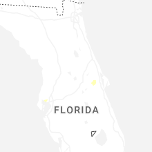
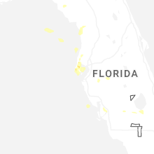
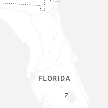
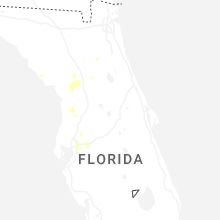
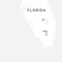
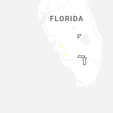
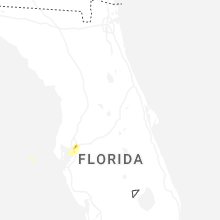


Connect with Interactive Hail Maps