

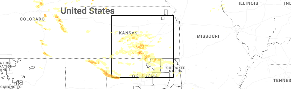
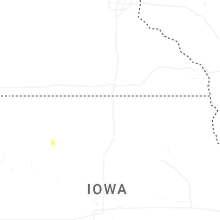
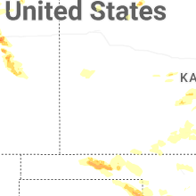
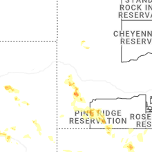
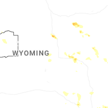
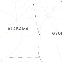
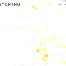
Hail Map for Tuesday, June 17, 2025
Number of Impacted Households on 6/17/2025
0
Impacted by 1" or Larger Hail
0
Impacted by 1.75" or Larger Hail
0
Impacted by 2.5" or Larger Hail
Square Miles of Populated Area Impacted on 6/17/2025
0
Impacted by 1" or Larger Hail
0
Impacted by 1.75" or Larger Hail
0
Impacted by 2.5" or Larger Hail


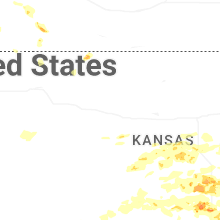
Cities Most Affected by Hail Storms of 6/17/2025
| Hail Size | Demographics of Zip Codes Affected | ||||||
|---|---|---|---|---|---|---|---|
| City | Count | Average | Largest | Pop Density | House Value | Income | Age |
| Arkansas City, KS | 4 | 2.58 | 3.81 | 106 | $48k | $31.3k | 36.8 |
| Conway Springs, KS | 2 | 2.25 | 2.75 | 15 | $65k | $42.0k | 35.7 |
| Trinidad, CO | 2 | 2.00 | 2.00 | 20 | $86k | $28.3k | 42.5 |
| Colorado Springs, CO | 2 | 1.75 | 1.75 | 4525 | $159k | $60.9k | 31.3 |
| Platteville, CO | 1 | 2.25 | 2.25 | 37 | $145k | $47.4k | 36.7 |
| Floydada, TX | 1 | 2.00 | 2.00 | 7 | $35k | $25.8k | 38.1 |
| Laramie, WY | 1 | 2.00 | 2.00 | 16 | $119k | $32.2k | 27.6 |
| Augusta, KS | 1 | 1.75 | 1.75 | 132 | $84k | $46.3k | 38.4 |
| Wellington, KS | 1 | 1.75 | 1.75 | 42 | $60k | $36.4k | 38.8 |
| Cimarron, NM | 1 | 1.75 | 1.75 | 1 | $80k | $30.0k | 46.9 |
| Lubbock, TX | 1 | 1.75 | 1.75 | 566 | $85k | $46.8k | 34.4 |
| Wolfforth, TX | 1 | 1.75 | 1.75 | 120 | $62k | $36.7k | 35.3 |
| Higgins, TX | 1 | 1.75 | 1.75 | 0 | $28k | $28.9k | 48.4 |
| Goddard, KS | 1 | 1.75 | 1.75 | 141 | $112k | $53.4k | 33.6 |
| Copan, OK | 1 | 1.75 | 1.75 | 10 | $51k | $30.5k | 46.8 |
Hail and Wind Damage Spotted on 6/17/2025
Filter by Report Type:Hail ReportsWind Reports
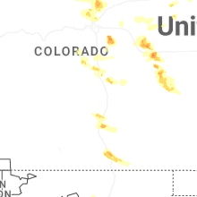
States Impacted
Colorado, Kansas, West Virginia, Wyoming, Alabama, Kentucky, South Dakota, Georgia, Mississippi, Oklahoma, Nebraska, South Carolina, Texas, Michigan, North Carolina, Tennessee, Indiana, Virginia, New Mexico, MarylandColorado
| Local Time | Report Details |
|---|---|
| 6:07 AM MDT | Quarter sized hail reported near Parker, CO, 28 miles SE of Denver, CO, report from mping: quarter (1.00 in.). |
| 6:18 AM MDT | Ping Pong Ball sized hail reported near Parker, CO, 28 miles SE of Denver, CO, report from mping: ping pong ball (1.50 in.). |
| 10:10 AM MDT | Quarter sized hail reported near Agate, CO, 59.4 miles ESE of Denver, CO |
| 10:56 AM MDT | Quarter sized hail reported near Colorado Springs, CO, 40.6 miles NNW of Pueblo, CO, report from mping: quarter (1.00 in.). |
| 10:57 AM MDT | Quarter sized hail reported near Colorado Springs, CO, 41.4 miles NNW of Pueblo, CO |
| 11:16 AM MDT | Quarter sized hail reported near Limon, CO, 72.7 miles SW of Yuma, CO |
| 12:15 PM MDT | Ping Pong Ball sized hail reported near Genoa, CO, 72.6 miles SW of Yuma, CO, report from mping: ping pong ball (1.50 in.). |
| 1:11 PM MDT | Quarter sized hail reported near Colorado Springs, CO, 30.5 miles NNE of Pueblo, CO, mping report. |
| 1:19 PM MDT | Quarter sized hail reported near Colorado Springs, CO, 46.5 miles NNW of Pueblo, CO |
| 1:20 PM MDT | Quarter sized hail reported near Colorado Springs, CO, 47.7 miles NNW of Pueblo, CO |
| 1:21 PM MDT | Quarter sized hail reported near Colorado Springs, CO, 47.4 miles NNW of Pueblo, CO |
| 1:23 PM MDT | Quarter sized hail reported near Colorado Springs, CO, 46.8 miles NNW of Pueblo, CO, report from mping: quarter (1.00 in.). |
| 1:25 PM MDT | Quarter sized hail reported near Colorado Springs, CO, 46.4 miles NNW of Pueblo, CO |
| 1:26 PM MDT | Quarter sized hail reported near Colorado Springs, CO, 45.3 miles NNW of Pueblo, CO, report from mping: quarter (1.00 in.). |
| 1:26 PM MDT | Quarter sized hail reported near Colorado Springs, CO, 46.2 miles NNW of Pueblo, CO |
| 1:28 PM MDT | Half Dollar sized hail reported near Colorado Springs, CO, 46.2 miles NNW of Pueblo, CO, report from mping: half dollar (1.25 in.). |
| 1:28 PM MDT | Ping Pong Ball sized hail reported near Colorado Springs, CO, 45.4 miles NNW of Pueblo, CO |
| 1:29 PM MDT | Ping Pong Ball sized hail reported near Colorado Springs, CO, 46.1 miles N of Pueblo, CO |
| 1:34 PM MDT | Quarter sized hail reported near Colorado Springs, CO, 45.5 miles NNW of Pueblo, CO, report from mping: quarter (1.00 in.). |
| 1:45 PM MDT | Golf Ball sized hail reported near Colorado Springs, CO, 44.1 miles N of Pueblo, CO, report from mping: golf ball (1.75 in.). |
| 1:46 PM MDT | Golf Ball sized hail reported near Colorado Springs, CO, 44.1 miles N of Pueblo, CO, report from mping: golf ball (1.75 in.). |
| 1:48 PM MDT | Quarter sized hail reported near Lafayette, CO, 19.4 miles NNW of Denver, CO |
| 1:52 PM MDT | Quarter sized hail reported near Windsor, CO, 53.9 miles N of Denver, CO |
| 1:54 PM MDT | Quarter sized hail reported near Manitou Springs, CO, 43.1 miles NNW of Pueblo, CO, report from mping: quarter (1.00 in.). |
| 1:54 PM MDT | Half Dollar sized hail reported near Colorado Springs, CO, 44.1 miles N of Pueblo, CO, report from mping: half dollar (1.25 in.). |
| 1:57 PM MDT | Quarter sized hail reported near Broomfield, CO, 13.6 miles NNW of Denver, CO, report from mping: quarter (1.00 in.). |
| 1:57 PM MDT | Quarter sized hail reported near Erie, CO, 20.4 miles NNW of Denver, CO, report from mping: quarter (1.00 in.). |
| 1:57 PM MDT | Quarter sized hail reported near Broomfield, CO, 14.1 miles NNW of Denver, CO, report from mping: quarter (1.00 in.). |
| 2:06 PM MDT | 8-10 inch diameter tree downe in adams county CO, 13.8 miles N of Denver, CO |
| 2:08 PM MDT | Hen Egg sized hail reported near Platteville, CO, 34.1 miles NNE of Denver, CO, delayed report. |
| 2:10 PM MDT | Quarter sized hail reported near Denver, CO, 11.1 miles N of Denver, CO, report from mping: quarter (1.00 in.). |
| 2:10 PM MDT | Quarter sized hail reported near Denver, CO, 13.8 miles N of Denver, CO |
| 2:11 PM MDT | Quarter sized hail reported near Denver, CO, 11.4 miles NNE of Denver, CO, report from mping: quarter (1.00 in.). |
| 2:35 PM MDT | Quarter sized hail reported near Rye, CO, 22.6 miles SSW of Pueblo, CO |
| 3:08 PM MDT | Quarter sized hail reported near Rye, CO, 29 miles SSW of Pueblo, CO |
| 3:12 PM MDT | Ping Pong Ball sized hail reported near Rye, CO, 29 miles SSW of Pueblo, CO |
| 4:29 PM MDT | Half Dollar sized hail reported near Trinidad, CO, 67.4 miles S of Pueblo, CO, report from mping: half dollar (1.25 in.). |
| 4:30 PM MDT | Hen Egg sized hail reported near Trinidad, CO, 68.1 miles S of Pueblo, CO, report from mping: hen egg (2.00 in.). |
| 4:32 PM MDT | Hen Egg sized hail reported near Trinidad, CO, 70.9 miles S of Pueblo, CO, delayed report with estimated time. used radar to line it up with where the hail core was. |
| 4:46 PM MDT | High_plains_coat_(awn64b2ee499b79fd1a67484a44 in yuma county CO, 35.1 miles S of Yuma, CO |
| 5:01 PM MDT | Recored by the lazy_td_farm_(awn677ff91dc822dd5e36a5f5e8) mesonet statio in yuma county CO, 33.3 miles ESE of Yuma, CO |
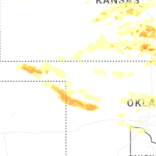
Kansas
| Local Time | Report Details |
|---|---|
| 7:40 AM CDT | Storm damage reported in sedgwick county KS, 13 miles SW of Wichita, KS |
| 7:47 AM CDT | Storm damage reported in sedgwick county KS, 13 miles SW of Wichita, KS |
| 2:22 PM CDT | Quarter sized hail reported near Mcpherson, KS, 48 miles NNW of Wichita, KS, kake relayed viewer report of quarter sized hail. time is estimated from radar. |
| 2:39 PM CDT | Quarter sized hail reported near Sterling, KS, 57.3 miles NW of Wichita, KS |
| 4:17 PM CDT | Half Dollar sized hail reported near Mount Hope, KS, 22.2 miles NW of Wichita, KS |
| 4:26 PM CDT | Law enforcement estimated 70 mph winds and nickel sized hai in sedgwick county KS, 22.2 miles NW of Wichita, KS |
| 4:28 PM CDT | Storm damage reported in sedgwick county KS, 13.3 miles WNW of Wichita, KS |
| 4:41 PM CDT | Storm damage reported in sedgwick county KS, 7.6 miles NW of Wichita, KS |
| 4:42 PM CDT | Estimated 60 to 70 mph winds near 34th n & ridge r in sedgwick county KS, 6.3 miles NW of Wichita, KS |
| 4:47 PM CDT | Tree limbs down with the 60 mph wind in sedgwick county KS, 8.4 miles WNW of Wichita, KS |
| 4:49 PM CDT | Storm damage reported in sedgwick county KS, 6.7 miles WNW of Wichita, KS |
| 4:59 PM CDT | Half Dollar sized hail reported near Wichita, KS, 7.8 miles N of Wichita, KS |
| 5:01 PM CDT | Overturned semi truck based on view from highway camer in sedgwick county KS, 3.9 miles WNW of Wichita, KS |
| 5:06 PM CDT | Six inch diameter branches dow in sedgwick county KS, 3.4 miles NE of Wichita, KS |
| 5:08 PM CDT | Several powerlines down throughout the metr in sedgwick county KS, 0.4 miles NE of Wichita, KS |
| 5:09 PM CDT | Storm damage reported in sedgwick county KS, 5.1 miles NE of Wichita, KS |
| 5:10 PM CDT | Half Dollar sized hail reported near Wichita, KS, 3.9 miles ENE of Wichita, KS |
| 5:13 PM CDT | 60 to 70 mph wind estimate at pawnee and olive in sedgwick county KS, 4 miles SE of Wichita, KS |
| 5:16 PM CDT | Storm damage reported in sedgwick county KS, 6.2 miles SE of Wichita, KS |
| 5:19 PM CDT | Quarter sized hail reported near Wichita, KS, 8 miles E of Wichita, KS |
| 5:22 PM CDT | Golf Ball sized hail reported near Conway Springs, KS, 30.7 miles SW of Wichita, KS |
| 5:30 PM CDT | Asos station kict wichita eisenhower airpor in sedgwick county KS, 5.8 miles WSW of Wichita, KS |
| 5:30 PM CDT | Power lines dow in butler county KS, 10.8 miles E of Wichita, KS |
| 5:34 PM CDT | Baseball sized hail reported near Conway Springs, KS, 28.3 miles SSW of Wichita, KS |
| 5:35 PM CDT | Awos station k3au augusta municipal airpor in butler county KS, 14.1 miles E of Wichita, KS |
| 5:35 PM CDT | Estimated 80 mph winds along with nickel sized hai in butler county KS, 12.9 miles E of Wichita, KS |
| 5:38 PM CDT | 2 foot diameter trees dow in butler county KS, 10.8 miles E of Wichita, KS |
| 5:42 PM CDT | Storm damage reported in butler county KS, 14.5 miles ENE of Wichita, KS |
| 5:51 PM CDT | Quarter sized hail reported near Augusta, KS, 19 miles E of Wichita, KS |
| 5:52 PM CDT | Quarter sized hail reported near Augusta, KS, 19 miles E of Wichita, KS |
| 5:52 PM CDT | Power pole snapped and leaning onto a hous in butler county KS, 19.5 miles E of Wichita, KS |
| 5:57 PM CDT | Golf Ball sized hail reported near Augusta, KS, 19.5 miles E of Wichita, KS |
| 6:10 PM CDT | Golf Ball sized hail reported near Wellington, KS, 28.1 miles S of Wichita, KS |
| 6:13 PM CDT | Storm damage reported in butler county KS, 30.5 miles E of Wichita, KS |
| 6:15 PM CDT | Storm damage reported in butler county KS, 30.5 miles E of Wichita, KS |
| 6:45 PM CDT | Ping Pong Ball sized hail reported near Geuda Springs, KS, 41.1 miles SSE of Wichita, KS |
| 7:03 PM CDT | Quarter sized hail reported near Arkansas City, KS, 45.6 miles SSE of Wichita, KS |
| 7:06 PM CDT | Golf Ball sized hail reported near Arkansas City, KS, 46.2 miles SSE of Wichita, KS |
| 7:07 PM CDT | Baseball sized hail reported near Arkansas City, KS, 45.6 miles SSE of Wichita, KS |
| 7:07 PM CDT | Tea Cup sized hail reported near Arkansas City, KS, 45.6 miles SSE of Wichita, KS |
| 7:13 PM CDT | Hen Egg sized hail reported near Arkansas City, KS, 45.6 miles SSE of Wichita, KS |
| 7:23 PM CDT | Storm damage reported in cowley county KS, 35.6 miles SSE of Wichita, KS |
| 8:32 PM CDT | Half Dollar sized hail reported near Garden Plain, KS, 19 miles W of Wichita, KS |
| 8:47 PM CDT | Golf Ball sized hail reported near Goddard, KS, 13 miles W of Wichita, KS |
| 8:54 PM CDT | Estimates 65 to 70 mph wind in sedgwick county KS, 13 miles SW of Wichita, KS |
| 9:06 PM CDT | Combined with dime sized hai in sedgwick county KS, 7.9 miles W of Wichita, KS |
| 9:12 PM CDT | Quarter sized hail reported near Wichita, KS, 1.8 miles SW of Wichita, KS |
| 9:12 PM CDT | Ks storm info estimates 60 to 65 mph and pea to dime sized hai in sedgwick county KS, 2.7 miles SSW of Wichita, KS |
| 9:20 PM CDT | Storm damage reported in sedgwick county KS, 10.2 miles S of Wichita, KS |
| 9:24 PM CDT | Storm damage reported in sedgwick county KS, 8.5 miles SSE of Wichita, KS |
| 9:48 PM CDT | Storm damage reported in sumner county KS, 31.6 miles SW of Wichita, KS |
| 10:54 PM CDT | Storm damage reported in cowley county KS, 39.2 miles SSE of Wichita, KS |
| 10:59 PM CDT | Asos station kwld strother field airpor in cowley county KS, 39.4 miles SSE of Wichita, KS |
| 12:42 AM CDT | Storm damage reported in montgomery county KS, 48.7 miles SSW of Chanute, KS |
West Virginia
| Local Time | Report Details |
|---|---|
| 10:14 AM EDT | One tree down due to thunderstorm winds along millvale/bloomery roa in jefferson county WV, 62.2 miles W of Baltimore, MD |
Wyoming
| Local Time | Report Details |
|---|---|
| 12:13 PM MDT | Quarter sized hail reported near Laramie, WY, 3.4 miles ESE of Laramie, WY, accumulating quarter sized hail on the east side of laramie. report received via facebook. |
| 12:15 PM MDT | Hen Egg sized hail reported near Laramie, WY, 6.9 miles ESE of Laramie, WY, photos of hail next to measuring tape. location estimated based on radar. |
| 1:40 PM MDT | Pea sized hail... very heavy rainfall... and estimated 60 mph wind in laramie county WY, 41.6 miles E of Laramie, WY |
| 1:57 PM MDT | Mesonet station up015 5.7 w burns (upr in laramie county WY, 59.3 miles E of Laramie, WY |
| 3:38 PM MDT | Mesonet station kskl skyline (wydot in carbon county WY, 52.9 miles WSW of Laramie, WY |
| 3:42 PM MDT | Mesonet station wy18 halleck ridge (wydot in carbon county WY, 56.5 miles WNW of Laramie, WY |
| 3:55 PM MDT | Quarter sized hail reported near Gillette, WY, 53.3 miles SSE of Gillette, WY |
| 4:00 PM MDT | Quarter sized hail reported near Gillette, WY, 53.3 miles SSE of Gillette, WY |
| 4:12 PM MDT | Mesonet station wy22 2.7 nw arlington (wydot in carbon county WY, 39.9 miles WNW of Laramie, WY |
Alabama
| Local Time | Report Details |
|---|---|
| 2:18 PM CDT | Tree uprooted onto powerline. time estimated based on rada in marshall county AL, 62 miles NE of Birmingham, AL |
| 2:55 PM CDT | Several trees down around talladega county... mainly in and around the city of talladeg in talladega county AL, 41.6 miles E of Birmingham, AL |
| 3:04 PM CDT | A couple trees down in perry county... including along highway 21 in perry county AL, 48.6 miles NNE of Camden, AL |
| 3:20 PM CDT | Numerous trees down across anniston... including quintard ave... rainbow cir... conger rd... m st... and interstate 2 in calhoun county AL, 57.4 miles E of Birmingham, AL |
| 3:40 PM CDT | A couple trees down in the heflin are in cleburne county AL, 69.4 miles W of Atlanta, GA |
| 3:52 PM CDT | A couple trees down in the fruithurst are in cleburne county AL, 59.8 miles W of Atlanta, GA |
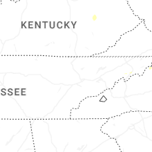
Kentucky
| Local Time | Report Details |
|---|---|
| 3:30 PM EDT | Tree down at intersection of mill and 5th streets. time estimated off of rada in laurel county KY, 39.8 miles S of Irvine, KY |
| 4:59 PM EDT | Social media report of a large tree down near the mouth of johnson fork in the hazel green area of wolfe county. time estimated via rada in wolfe county KY, 30.9 miles E of Irvine, KY |
| 5:40 PM EDT | Tree reported on a truck along with powerlines. time of report - probably from an earlier stor in clay county KY, 39 miles SSE of Irvine, KY |
| 11:00 PM EDT | Tree down on a vehicle and utility lines. could have been from an earlier stor in rockcastle county KY, 26.4 miles SW of Irvine, KY |
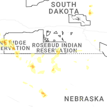
South Dakota
| Local Time | Report Details |
|---|---|
| 1:32 PM MDT | Half Dollar sized hail reported near Hill City, SD, 21.3 miles WSW of Rapid City, SD, a lot of pea sized hail... also. |
| 2:07 PM MDT | Quarter sized hail reported near Keystone, SD, 16.6 miles SW of Rapid City, SD, report from mping: quarter (1.00 in.). |
| 2:10 PM MDT | Half Dollar sized hail reported near Keystone, SD, 16.6 miles SW of Rapid City, SD, report from mping: half dollar (1.25 in.). |
| 2:52 PM MDT | Half Dollar sized hail reported near Hot Springs, SD, 44.6 miles SSW of Rapid City, SD |
Georgia
| Local Time | Report Details |
|---|---|
| 5:04 PM EDT | A few trees down along brewster field road and garmon roa in polk county GA, 56.1 miles WNW of Atlanta, GA |
| 5:12 PM EDT | Tree down on a vehicle near the intersection of lees chapel road and lovvorn roa in polk county GA, 51 miles WNW of Atlanta, GA |
| 5:15 PM EDT | Powerlines down on the 200th block of lowery road near rockmar in polk county GA, 44.4 miles WNW of Atlanta, GA |
| 5:20 PM EDT | Tree down along cut log road near pine pitch roa in polk county GA, 51.2 miles WNW of Atlanta, GA |
| 5:20 PM EDT | Tree reported down on a house near the intersection of cooper rd and steward r in catoosa county GA, 19.1 miles ESE of Chattanooga, TN |
| 6:03 PM EDT | Tree down along interstate 20 east near fulton industrial boulevar in fulton county GA, 8.1 miles W of Atlanta, GA |
| 6:22 PM EDT | Trees and wires down near the intersection of jones avenue and south main stree in pickens county GA, 48.4 miles N of Atlanta, GA |
| 6:25 PM EDT | Trees down along woodall roa in polk county GA, 50.9 miles WNW of Atlanta, GA |
| 6:34 PM EDT | Tree down near the intersection of roswell road and northridge crossin in fulton county GA, 16.1 miles N of Atlanta, GA |
| 6:35 PM EDT | Tree reported down in the parking lot of an apartment complex on cedar ru in fulton county GA, 17.6 miles N of Atlanta, GA |
| 6:45 PM EDT | Trees down at the end of tolhurst r in white county GA, 69.9 miles NNE of Atlanta, GA |
| 6:50 PM EDT | Tree down on a home near the intersection of testatee gap valley rd and bell shadows d in white county GA, 68.7 miles NNE of Atlanta, GA |
| 6:55 PM EDT | Tree down along pine trail near twin creek driv in lumpkin county GA, 55 miles NNE of Atlanta, GA |
| 7:20 PM EDT | Tree down across 115 e in cleveland g in white county GA, 64.4 miles WSW of Greenville, SC |
| 7:43 PM EDT | Trees down in carnesvill in franklin county GA, 47.9 miles SW of Greenville, SC |
| 7:46 PM EDT | Tree and large limbs down along cliffs ridge r in stephens county GA, 40.9 miles WSW of Greenville, SC |
| 7:54 PM EDT | Trees down in lavoni in franklin county GA, 39.6 miles SW of Greenville, SC |
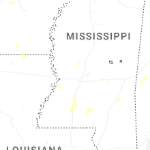
Mississippi
| Local Time | Report Details |
|---|---|
| 5:12 PM CDT | Law enforcement reported a tree down on lily r in copiah county MS, 27.1 miles SSW of Jackson, MS |
| 6:04 PM CDT | Local law enforcement reported multiple trees and powerlines down across northeastern portions of lincoln count in lincoln county MS, 45.7 miles SSW of Jackson, MS |
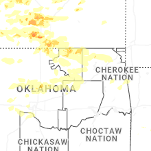
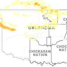
Oklahoma
| Local Time | Report Details |
|---|---|
| 5:37 PM CDT | Ping Pong Ball sized hail reported near Hooker, OK, 82.1 miles SSW of Garden City, KS, ping pong ball size hail fell. report via social media. |
| 6:32 PM CDT | Ping Pong Ball sized hail reported near Balko, OK, 79.7 miles W of Woodward, OK, hail up to ping pong ball size fell. |
| 7:47 PM CDT | Ping Pong Ball sized hail reported near Braman, OK, 48.8 miles S of Wichita, KS, quarter to ping pong ball sized hail noted on dot cameras. |
| 8:10 PM CDT | Storm damage reported in ellis county OK, 36.7 miles SW of Woodward, OK |
| 8:34 PM CDT | Storm damage reported in osage county OK, 52.8 miles NNW of Tulsa, OK |
| 8:37 PM CDT | Half Dollar sized hail reported near Arnett, OK, 35.4 miles SW of Woodward, OK, half dollar sized hail reported by a trained spotter. |
| 8:37 PM CDT | Half Dollar sized hail reported near Arnett, OK, 36.8 miles SW of Woodward, OK |
| 8:40 PM CDT | Quarter sized hail reported near Arnett, OK, 37.2 miles SSW of Woodward, OK, report from mping: quarter (1.00 in.). |
| 8:47 PM CDT | Corrects previous tstm wnd gst report from forake in osage county OK, 59.1 miles NNW of Tulsa, OK |
| 8:47 PM CDT | Storm damage reported in osage county OK, 59.1 miles NNW of Tulsa, OK |
| 8:53 PM CDT | Roof damage and power ou in osage county OK, 40.7 miles NNW of Tulsa, OK |
| 8:55 PM CDT | Storm damage reported in dewey county OK, 25.9 miles S of Woodward, OK |
| 9:05 PM CDT | Ping Pong Ball sized hail reported near Pawhuska, OK, 51.2 miles NNW of Tulsa, OK, report from mping: ping pong ball (1.50 in.). |
| 9:14 PM CDT | Half Dollar sized hail reported near Hooker, OK, 84.2 miles SSW of Garden City, KS |
| 9:20 PM CDT | Storm damage reported in washington county OK, 31.1 miles N of Tulsa, OK |
| 9:20 PM CDT | Storm damage reported in dewey county OK, 43.3 miles SSE of Woodward, OK |
| 9:27 PM CDT | Golf Ball sized hail reported near Copan, OK, 51.8 miles N of Tulsa, OK |
| 9:40 PM CDT | Personal weather statio in alfalfa county OK, 69.6 miles ENE of Woodward, OK |
| 9:45 PM CDT | Storm damage reported in blaine county OK, 62.7 miles SE of Woodward, OK |
| 9:55 PM CDT | Storm damage reported in blaine county OK, 57.6 miles WNW of Oklahoma City, OK |
| 10:05 PM CDT | Storm damage reported in nowata county OK, 46.8 miles NNE of Tulsa, OK |
| 11:45 PM CDT | Numerous 10-12 inch thick limbs dow in tulsa county OK, 11.6 miles W of Tulsa, OK |
| 11:55 PM CDT | Storm damage reported in osage county OK, 31.7 miles NW of Tulsa, OK |
| 11:58 PM CDT | Damage to promenade mal in tulsa county OK, 6.4 miles ESE of Tulsa, OK |
| 12:00 AM CDT | Storm damage reported in osage county OK, 52.8 miles NNW of Tulsa, OK |
| 12:05 AM CDT | 6 inch limbs down 51st and yal in tulsa county OK, 4.3 miles ESE of Tulsa, OK |
| 12:10 AM CDT | Storm damage reported in osage county OK, 31.7 miles NW of Tulsa, OK |
| 12:31 AM CDT | Transformers being blown. estimated 70mp in washington county OK, 41.4 miles N of Tulsa, OK |
| 12:34 AM CDT | Storm damage reported in washington county OK, 52.7 miles N of Tulsa, OK |
| 12:40 AM CDT | Storm damage reported in washington county OK, 52.7 miles N of Tulsa, OK |
| 12:45 AM CDT | Storm damage reported in rogers county OK, 32 miles NNE of Tulsa, OK |
| 12:47 AM CDT | Storm damage reported in rogers county OK, 22.4 miles NNE of Tulsa, OK |
| 12:55 AM CDT | Tree on house at 96th and newton plac in cherokee county OK, 48.1 miles NW of Fort Smith, AR |
| 1:25 AM CDT | Storm damage reported in adair county OK, 45.7 miles NNW of Fort Smith, AR |
| 1:25 AM CDT | Tree down on hwy 10 and cnty road 652 blocking one lan in ottawa county OK, 76.5 miles SSE of Chanute, KS |
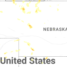
Nebraska
| Local Time | Report Details |
|---|---|
| 5:29 PM MDT | Recorded at mesonet station near benkelman. id: home_(awn648deaadf07e12c3e9f48bd1 in dundy county NE, 52.5 miles NNW of Colby, KS |
| 5:36 PM MDT | Imperial aso in chase county NE, 62.3 miles SW of North Platte, NE |
| 6:49 PM CDT | Ping Pong Ball sized hail reported near Palisade, NE, 54.4 miles SSW of North Platte, NE |
South Carolina
| Local Time | Report Details |
|---|---|
| 7:58 PM EDT | Social media report of a tree snapped in half in westminste in oconee county SC, 30.8 miles WSW of Greenville, SC |
| 8:04 PM EDT | Tree down across powerline in mountain res in oconee county SC, 31.3 miles W of Greenville, SC |
| 8:09 PM EDT | Tree down on powerlines in tamasse in oconee county SC, 24.1 miles W of Greenville, SC |
| 8:15 PM EDT | Trees down around the pendleton are in anderson county SC, 16.1 miles SW of Greenville, SC |
| 8:15 PM EDT | Trees down in the la france are in anderson county SC, 18 miles SSW of Greenville, SC |
| 8:19 PM EDT | Social media report of trees and powerlines down in six mil in pickens county SC, 12.6 miles W of Greenville, SC |
| 8:20 PM EDT | Multiple trees down around centra in pickens county SC, 12.4 miles SW of Greenville, SC |
| 8:25 PM EDT | Trained spotter estimated 60mph wind gusts along hwy 28 in anderso in anderson county SC, 24.4 miles S of Greenville, SC |
| 8:25 PM EDT | Several trees reported down in the starr are in anderson county SC, 31.6 miles S of Greenville, SC |
| 8:25 PM EDT | A couple trees down around iv in anderson county SC, 36.1 miles S of Greenville, SC |
| 8:26 PM EDT | Trees down near pickens high schoo in pickens county SC, 8.7 miles NW of Greenville, SC |
| 8:30 PM EDT | Social media report of trees and powerlines down in libert in pickens county SC, 5.8 miles WSW of Greenville, SC |
| 8:30 PM EDT | Tree across the road at glassy mountai in pickens county SC, 5.8 miles NW of Greenville, SC |
| 8:35 PM EDT | Several trees down in the easley are in pickens county SC, 1.2 miles E of Greenville, SC |
| 8:35 PM EDT | Trees down in pumpkintow in pickens county SC, 12 miles NNW of Greenville, SC |
| 8:36 PM EDT | Trees and powerlines down in dacusvill in pickens county SC, 7.9 miles NNE of Greenville, SC |
| 8:37 PM EDT | Trees on powerlines in the piedmont are in anderson county SC, 11.7 miles SE of Greenville, SC |
| 8:41 PM EDT | Trees and powerlines down around powdersvill in anderson county SC, 6.9 miles ESE of Greenville, SC |
| 8:43 PM EDT | Tree down on a house along notchwood cour in greenville county SC, 7.9 miles ENE of Greenville, SC |
| 8:43 PM EDT | Trees and powerlines down in the moonville are in greenville county SC, 14.2 miles ESE of Greenville, SC |
| 8:46 PM EDT | Trees and powerlines down in the slater-marietta are in greenville county SC, 14.9 miles NNE of Greenville, SC |
| 8:46 PM EDT | Trees and powerlines down in the travelers rest are in greenville county SC, 13.2 miles NE of Greenville, SC |
| 8:47 PM EDT | Powerlines down in mauldi in greenville county SC, 16.9 miles ESE of Greenville, SC |
| 8:51 PM EDT | Trees and powerlines down in tigervill in greenville county SC, 21 miles NE of Greenville, SC |
| 8:51 PM EDT | Picture of a snapped tree on the north side of greenvill in greenville county SC, 13.2 miles ENE of Greenville, SC |
| 8:52 PM EDT | Tree down partially blocking bridges road just west of holland roa in greenville county SC, 18.4 miles E of Greenville, SC |
| 8:55 PM EDT | Trees and powerlines down in the five forks are in greenville county SC, 21.2 miles E of Greenville, SC |
| 8:56 PM EDT | Trees down in taylor in greenville county SC, 18.1 miles ENE of Greenville, SC |
| 8:57 PM EDT | Trees and powerlines down in the i-85/pelham road are in greenville county SC, 19.4 miles E of Greenville, SC |
| 9:00 PM EDT | Trees and powerlines down in the harrison bridge rd area of simpsonvill in greenville county SC, 21.4 miles ESE of Greenville, SC |
| 9:01 PM EDT | Several trees down around greer... a few of which fell on powerline in greenville county SC, 22.3 miles ENE of Greenville, SC |
| 9:06 PM EDT | Tree down on powerline in campobell in spartanburg county SC, 32.4 miles NE of Greenville, SC |
| 9:06 PM EDT | Tree down in landru in spartanburg county SC, 33.5 miles NE of Greenville, SC |
| 9:07 PM EDT | Trees down on powerlines in the reidville are in spartanburg county SC, 27.9 miles E of Greenville, SC |
| 9:07 PM EDT | Trees down in lyma in spartanburg county SC, 28.2 miles ENE of Greenville, SC |
| 9:07 PM EDT | Multiple trees and powerlines dow in spartanburg county SC, 28.5 miles E of Greenville, SC |
| 9:12 PM EDT | Spotter report with video. estimated 50-60 mph winds near batesbur in lexington county SC, 38.5 miles NE of Augusta, GA |
| 9:12 PM EDT | Tree down in inma in spartanburg county SC, 32.7 miles ENE of Greenville, SC |
| 9:13 PM EDT | Sc highway patrol reported trees down along highway 391 south of prosperit in newberry county SC, 52.3 miles NNE of Augusta, GA |
| 9:16 PM EDT | Several trees down around the woodruff area... some on powerline in spartanburg county SC, 32.5 miles E of Greenville, SC |
| 9:16 PM EDT | Trees and powerlines down in roebuc in spartanburg county SC, 36 miles E of Greenville, SC |
| 9:17 PM EDT | Tree down across powerline in shannon fores in spartanburg county SC, 36.3 miles E of Greenville, SC |
| 9:17 PM EDT | Tree down near lake bowe in spartanburg county SC, 38.1 miles ENE of Greenville, SC |
| 9:17 PM EDT | Frequent 50-60mph gusts observe in spartanburg county SC, 36.1 miles E of Greenville, SC |
| 9:17 PM EDT | Trees down on powerlines on the west side of spartanbur in spartanburg county SC, 35.5 miles ENE of Greenville, SC |
| 9:22 PM EDT | Multiple trees and powerlines down around spartanbur in spartanburg county SC, 39 miles ENE of Greenville, SC |
| 9:23 PM EDT | Trees down in the pauline are in spartanburg county SC, 41.5 miles E of Greenville, SC |
| 9:23 PM EDT | Tree down on a house along lucerne driv in spartanburg county SC, 39.7 miles E of Greenville, SC |
| 9:23 PM EDT | Several trees and powerlines down in northeast spartanburg count in spartanburg county SC, 44.8 miles ENE of Greenville, SC |
| 9:26 PM EDT | Sc dept of public safety reported a tree down in the roadway along amicks ferry rd. time estimated by rada in lexington county SC, 54.8 miles NE of Augusta, GA |
| 9:30 PM EDT | Sc highway patrol reported trees down near i-26 in chapi in lexington county SC, 61.3 miles NE of Augusta, GA |
| 9:30 PM EDT | Sc highway patrol reported trees down near southland road and golden jubilee roa in lexington county SC, 48.6 miles NE of Augusta, GA |
| 9:30 PM EDT | Sc highway patrol reported trees down near augusta highway and golden jubilee roa in lexington county SC, 49.1 miles NE of Augusta, GA |
| 9:33 PM EDT | Trees down in the cowpens are in spartanburg county SC, 47.3 miles ENE of Greenville, SC |
| 9:33 PM EDT | Trees down in the pacolet are in spartanburg county SC, 48 miles E of Greenville, SC |
| 9:53 PM EDT | Sc dept of public safety reported a tree in the roadway along commerce blvd. time estimated by rada in fairfield county SC, 64.9 miles S of Charlotte, NC |
| 9:54 PM EDT | Spotter estimated 50-60 mph winds near mineral springs road. radar suggests a downburst in this are in lexington county SC, 57.8 miles NE of Augusta, GA |
Texas
| Local Time | Report Details |
|---|---|
| 7:01 PM CDT | Quarter sized hail reported near Floydada, TX, 40.1 miles ENE of Lubbock, TX |
| 7:01 PM CDT | Hen Egg sized hail reported near Floydada, TX, 40.1 miles ENE of Lubbock, TX, corrects previous hail report from floydada. |
| 7:10 PM CDT | Half Dollar sized hail reported near Lubbock, TX, 9.6 miles SW of Lubbock, TX, report from mping: half dollar (1.25 in.). |
| 7:14 PM CDT | Quarter sized hail reported near Lubbock, TX, 7.7 miles SW of Lubbock, TX |
| 7:19 PM CDT | Measured by the ttu mesone in lubbock county TX, 16.3 miles SW of Lubbock, TX |
| 7:25 PM CDT | Quarter sized hail reported near Booker, TX, 58.3 miles W of Woodward, OK |
| 7:25 PM CDT | Golf Ball sized hail reported near Wolfforth, TX, 14.1 miles SW of Lubbock, TX |
| 7:35 PM CDT | Golf Ball sized hail reported near Lubbock, TX, 9.3 miles SSW of Lubbock, TX |
| 7:41 PM CDT | Quarter sized hail reported near Lubbock, TX, 10 miles SSW of Lubbock, TX, report from mping: quarter (1.00 in.). |
| 7:53 PM CDT | Golf Ball sized hail reported near Higgins, TX, 46.7 miles WSW of Woodward, OK, report from mping: golf ball (1.75 in.). |
| 7:58 PM CDT | Quarter sized hail reported near , , 49.3 miles WSW of Woodward, OK, report from mping: quarter (1.00 in.). |
| 7:59 PM CDT | Quarter sized hail reported near Slaton, TX, 13.5 miles SSE of Lubbock, TX, report from mping: quarter (1.00 in.). |
| 8:00 PM CDT | Quarter sized hail reported near Wilson, TX, 14.8 miles SSE of Lubbock, TX, report from mping: quarter (1.00 in.). |
| 8:14 PM CDT | Measured by ttu mesone in dickens county TX, 48.6 miles ENE of Lubbock, TX |
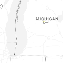
Michigan
| Local Time | Report Details |
|---|---|
| 8:30 PM EDT | Tree down onto a house. time estimated from rada in cass county MI, 69.3 miles NW of Fort Wayne, IN |
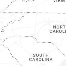
North Carolina
| Local Time | Report Details |
|---|---|
| 8:42 PM EDT | Trees down on utility equipmen in transylvania county NC, 29.1 miles NNW of Greenville, SC |
| 9:02 PM EDT | Trees down on utility equipmen in henderson county NC, 31.6 miles NNE of Greenville, SC |
| 9:06 PM EDT | Several trees down in the tryon are in polk county NC, 33.2 miles NE of Greenville, SC |
| 9:07 PM EDT | Trees down on utility equipmen in polk county NC, 31.6 miles NNE of Greenville, SC |
| 9:18 PM EDT | Social media picture of several trees down in mill sprin in polk county NC, 40.9 miles NE of Greenville, SC |
| 9:27 PM EDT | Trees and powerlines down around the rutherfordton are in rutherford county NC, 51.9 miles NE of Greenville, SC |
| 9:34 PM EDT | Trees down in forest cit in rutherford county NC, 53.8 miles NE of Greenville, SC |
| 9:38 PM EDT | Trees and powerlines downed around ellenbor in rutherford county NC, 52.7 miles W of Charlotte, NC |
| 9:43 PM EDT | Trees and powerlines down on the west side of shelb in cleveland county NC, 44.1 miles W of Charlotte, NC |
| 9:59 PM EDT | Several trees and large limbs down in the casar... belwood and fallston areas of northern cleveland count in cleveland county NC, 42.4 miles WNW of Charlotte, NC |
Tennessee
| Local Time | Report Details |
|---|---|
| 9:08 PM EDT | Quarter sized hail reported near Church Hill, TN, 31.3 miles W of Bristol, TN, hail from penny to quarter sized fell approximately for 1 minute. chipped the windshield of a car in a couple of places. at time of report (9:25)... 1 inch of rainfall |
| 9:12 PM EDT | Social media picture of a 1-3 inch diameter tree branch laying on ground after severe thunderstorm passage near mountain view road close to church hill t in hawkins county TN, 27.2 miles WSW of Bristol, TN |
| 9:15 PM EDT | 3 trees down in church hill area. time estimated from rada in hawkins county TN, 27.5 miles W of Bristol, TN |
| 9:27 PM EDT | Trees downe in sullivan county TN, 9.5 miles SSW of Bristol, TN |
Indiana
| Local Time | Report Details |
|---|---|
| 9:10 PM EDT | Report of a large ash tree down on quail valley drive. time estimated from rada in st. joseph county IN, 72.1 miles NW of Fort Wayne, IN |
Virginia
| Local Time | Report Details |
|---|---|
| 10:00 PM EDT | Tree reported down. time estimated from rada in russell county VA, 20.2 miles N of Bristol, TN |
New Mexico
| Local Time | Report Details |
|---|---|
| 8:00 PM MDT | Golf Ball sized hail reported near Cimarron, NM, 34.9 miles E of Taos, NM, photo from public of golf ball size hail near philmont scout ranch. |
Maryland
| Local Time | Report Details |
|---|---|
| 10:14 PM EDT | Corrects previous tstm wnd dmg report from 2 nne myersville. one tree down due to thunderstorm winds along harp hill roa in frederick county MD, 52.5 miles WNW of Baltimore, MD |
| 2:33 AM EDT | One tree down due to thunderstorm winds at the intersection of liberty road and wards chapel road in randallstow in baltimore county MD, 15.4 miles WNW of Baltimore, MD |
Connect with Interactive Hail Maps