

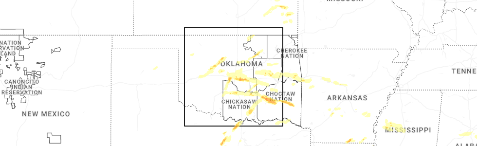
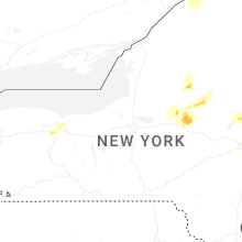
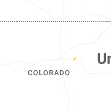
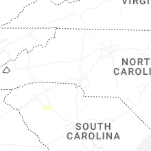
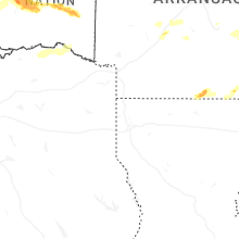
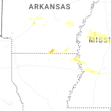
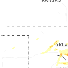
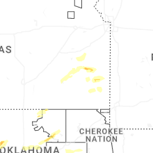
Hail Map for Saturday, May 17, 2025
Number of Impacted Households on 5/17/2025
0
Impacted by 1" or Larger Hail
0
Impacted by 1.75" or Larger Hail
0
Impacted by 2.5" or Larger Hail
Square Miles of Populated Area Impacted on 5/17/2025
0
Impacted by 1" or Larger Hail
0
Impacted by 1.75" or Larger Hail
0
Impacted by 2.5" or Larger Hail

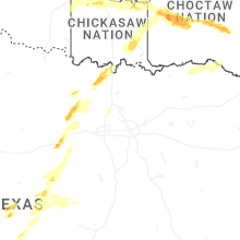
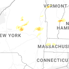
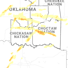
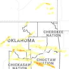
Cities Most Affected by Hail Storms of 5/17/2025
| Hail Size | Demographics of Zip Codes Affected | ||||||
|---|---|---|---|---|---|---|---|
| City | Count | Average | Largest | Pop Density | House Value | Income | Age |
| Mustang, OK | 3 | 2.25 | 2.75 | 424 | $87k | $50.7k | 36.8 |
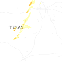
| Bridgeport, TX | 2 | 3.00 | 3.25 | 81 | $83k | $40.2k | 35.8 |
| Tuttle, OK | 2 | 2.25 | 2.75 | 104 | $91k | $45.0k | 38.3 |
| Newalla, OK | 1 | 4.00 | 4.00 | 152 | $88k | $42.8k | 41.1 |
| Oklahoma City, OK | 2 | 2.00 | 2.25 | 2044 | $78k | $29.9k | 31.8 |
| Shawnee, OK | 1 | 2.25 | 2.25 | 205 | $80k | $35.3k | 35.4 |
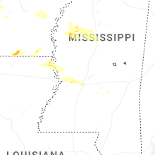
| Raymond, MS | 1 | 2.00 | 2.00 | 70 | $109k | $45.2k | 38.6 |
| Yukon, OK | 1 | 2.00 | 2.00 | 529 | $87k | $49.1k | 35.3 |
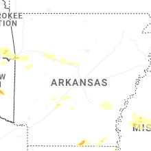
| Huttig, AR | 1 | 2.00 | 2.00 | 6 | $31k | $26.7k | 43.9 |
| Cleveland, OK | 1 | 1.75 | 1.75 | 100 | $68k | $32.7k | 41.5 |
| Wardville, OK | 1 | 1.75 | 1.75 | 4 | $31k | $26.9k | 49.7 |
| Muenster, TX | 1 | 1.75 | 1.75 | 11 | $80k | $43.9k | 39.5 |
| Strong, AR | 1 | 1.75 | 1.75 | 7 | $36k | $24.4k | 43.8 |
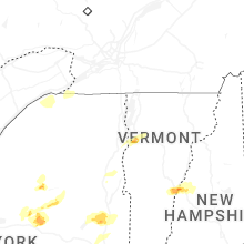
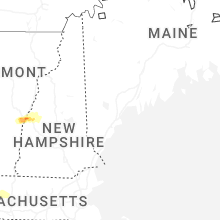
| Stowe, VT | 1 | 1.75 | 1.75 | 63 | $213k | $52.4k | 44.9 |
| Hominy, OK | 1 | 1.75 | 1.75 | 12 | $42k | $25.0k | 37.9 |
| Charlotte, VT | 1 | 1.75 | 1.75 | 96 | $203k | $62.3k | 44.8 |
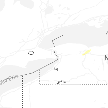
Hail and Wind Damage Spotted on 5/17/2025
Filter by Report Type:Hail ReportsWind Reports
States Impacted
Vermont, Georgia, New York, Mississippi, Wyoming, Texas, Pennsylvania, Utah, Arkansas, Oklahoma, Louisiana, Massachusetts, New Hampshire, Nevada, Arizona, AlabamaVermont
| Local Time | Report Details |
|---|---|
| 9:14 AM EDT | Tree down on berlin pond road. correction to previous reports event tim in washington county VT, 35 miles SE of Burlington, VT |
| 9:20 AM EDT | Tree down on berlin pond road in washington county VT, 35 miles SE of Burlington, VT |
| 2:40 PM EDT | Golf Ball sized hail reported near Charlotte, VT, 12.3 miles S of Burlington, VT |
| 2:45 PM EDT | Quarter sized hail reported near Hinesburg, VT, 11.5 miles SSE of Burlington, VT |
| 2:50 PM EDT | Tree down near sheehan green with nichel hail in chittenden county VT, 10.8 miles S of Burlington, VT |
| 3:02 PM EDT | Ping Pong Ball sized hail reported near Richmond, VT, 11.2 miles ESE of Burlington, VT, 0.5-1.5 inch hail |
| 3:04 PM EDT | Quarter sized hail reported near Richmond, VT, 11.8 miles ESE of Burlington, VT |
| 3:05 PM EDT | Half Dollar sized hail reported near Williston, VT, 9 miles SE of Burlington, VT |
| 3:24 PM EDT | Tree down on powerlines on gorham ln in addison county VT, 31.5 miles S of Burlington, VT |
| 3:36 PM EDT | Tree down on reynolds r in franklin county VT, 18.6 miles N of Burlington, VT |
| 3:42 PM EDT | Golf Ball sized hail reported near Stowe, VT, 21.6 miles E of Burlington, VT, smugglers notch state park reports golf ball sized hail |
| 3:47 PM EDT | Quarter sized hail reported near Stowe, VT, 22.5 miles E of Burlington, VT |
| 4:06 PM EDT | Two trees snapped in the price chopper parking lot in lamoille county VT, 31.5 miles ENE of Burlington, VT |
| 4:52 PM EDT | Country club rd has tree down and partially washed out in washington county VT, 40.4 miles ESE of Burlington, VT |
| 6:12 PM EDT | Trees and powerlines down in the village of hartford in windsor county VT, 71.2 miles SE of Burlington, VT |
| 6:31 PM EDT | Report of a tree down along rte 7a near the bennington and shaftbury town lin in bennington county VT, 38 miles ENE of Schenectady, NY |
| 6:35 PM EDT | Report of a tree down along vt rte 9 and furnace grove r in bennington county VT, 40.4 miles E of Schenectady, NY |
| 6:45 PM EDT | One tree uprooted with several snapped near the intersection of rte 9 and woodford state park rd. time estimated from rada in bennington county VT, 46.1 miles E of Schenectady, NY |
Georgia
| Local Time | Report Details |
|---|---|
| 9:27 AM EDT | Several trees down along halls bridge roa in butts county GA, 40 miles SE of Atlanta, GA |
New York
| Local Time | Report Details |
|---|---|
| 12:36 PM EDT | Power poles and wires dow in wyoming county NY, 40.2 miles E of Buffalo, NY |
| 12:52 PM EDT | Three limbs down on maiden road near ny-39 in monroe county NY, 65.4 miles ENE of Buffalo, NY |
| 12:54 PM EDT | Quarter sized hail reported near Scottsville, NY, 58 miles E of Buffalo, NY |
| 12:58 PM EDT | Quarter sized hail reported near West Henrietta, NY, 61.9 miles ENE of Buffalo, NY, twitter report. size estimated from photo. |
| 1:05 PM EDT | Very large tree down on crestline d in monroe county NY, 69.1 miles W of Syracuse, NY |
| 1:10 PM EDT | Large tree down blocking the eastbound lanes of ny route 44 in monroe county NY, 69.1 miles W of Syracuse, NY |
| 1:10 PM EDT | Power pole broken and lines down on glazer d in monroe county NY, 68.7 miles W of Syracuse, NY |
| 1:12 PM EDT | Several traffic lights blown down along panorama trai in monroe county NY, 68.1 miles W of Syracuse, NY |
| 1:20 PM EDT | Quarter sized hail reported near Schenectady, NY, 4.8 miles NNW of Schenectady, NY, report relayed from broadcast media of quarter size hail in glenville. time estimated from radar. |
| 1:22 PM EDT | Large tree down blocking parce av in monroe county NY, 65.5 miles W of Syracuse, NY |
| 1:27 PM EDT | Tree blocking most of risser roa in ontario county NY, 58.9 miles W of Syracuse, NY |
| 1:37 PM EDT | Report of tree and wires down on eastside drive in ballston lak in saratoga county NY, 7.6 miles NNE of Schenectady, NY |
| 1:38 PM EDT | Tree blocking gurnee road near ny-3 in wayne county NY, 50.3 miles W of Syracuse, NY |
| 1:44 PM EDT | Tree and wires down on carter road south of cross roa in ontario county NY, 44 miles W of Syracuse, NY |
| 1:56 PM EDT | Quarter sized hail reported near Mechanicville, NY, 13 miles NNE of Schenectady, NY, most hail was pea size but a few were as big as quarter size. |
| 2:17 PM EDT | Trees and wires down on rude s in cayuga county NY, 20.9 miles W of Syracuse, NY |
| 2:17 PM EDT | Trees and wires down on putnam r in cayuga county NY, 19.9 miles W of Syracuse, NY |
| 2:17 PM EDT | Trees and wires down on hoyt roa in cayuga county NY, 20.4 miles W of Syracuse, NY |
| 2:25 PM EDT | Tree uprooted and down onto a house with wires involved per county dispatc in onondaga county NY, 16.9 miles W of Syracuse, NY |
| 2:27 PM EDT | Wires down per county dispatc in onondaga county NY, 14 miles W of Syracuse, NY |
| 2:31 PM EDT | Tree down on roof per county dispatc in onondaga county NY, 7.3 miles W of Syracuse, NY |
| 2:37 PM EDT | Tree and large branches down at new york state fairgrounds from strong outflo in onondaga county NY, 4.2 miles WNW of Syracuse, NY |
| 2:41 PM EDT | Tree down on hous in onondaga county NY, 7.5 miles NW of Syracuse, NY |
| 2:55 PM EDT | Tree down on power line in clinton county NY, 23.8 miles WNW of Burlington, VT |
| 2:58 PM EDT | Tree on wires in hastings... n in oswego county NY, 22.1 miles N of Syracuse, NY |
| 3:00 PM EDT | Small tree down on rt 10 lewis wadhams road in essex county NY, 20.4 miles SW of Burlington, VT |
| 3:12 PM EDT | Trees down near intersection of turner rd and soper s in clinton county NY, 21.4 miles WNW of Burlington, VT |
| 3:18 PM EDT | Ledge hill road tree on power lines in essex county NY, 24.3 miles SW of Burlington, VT |
| 3:20 PM EDT | Report of a tree down along valentine pond rd. time estimated from rada in warren county NY, 58.9 miles SSW of Burlington, VT |
| 3:36 PM EDT | Corrects previous hail report from 5 w gansevoort. report of trees and wires down on corinth mountain rd in wilto in saratoga county NY, 27.8 miles NNE of Schenectady, NY |
| 3:36 PM EDT | Quarter sized hail reported near Gansevoort, NY, 27.8 miles NNE of Schenectady, NY, report of trees and wires down on corinth mountain rd in wilton. |
| 3:42 PM EDT | A few trees down in the area along with wires and a snapped pol in oneida county NY, 37.9 miles E of Syracuse, NY |
| 3:48 PM EDT | Wires dow in oneida county NY, 44.1 miles E of Syracuse, NY |
| 3:55 PM EDT | Quarter sized hail reported near Utica, NY, 47.2 miles E of Syracuse, NY, report passed from wktv in deerfield/utica. |
| 3:55 PM EDT | Tree down on propert in oneida county NY, 49.1 miles E of Syracuse, NY |
| 4:25 PM EDT | Report of trees and wires down along curtiss rd near salisbur in herkimer county NY, 50.9 miles WNW of Schenectady, NY |
| 4:25 PM EDT | Trees down along spruce lake road north of salisbur in herkimer county NY, 51.8 miles WNW of Schenectady, NY |
| 4:45 PM EDT | Trees and wires down near the saratoga rv par in saratoga county NY, 29.4 miles NNE of Schenectady, NY |
| 5:15 PM EDT | Report of trees and wires down along rte. 40 south of greenwic in washington county NY, 27.4 miles NE of Schenectady, NY |
| 5:20 PM EDT | Report of tree down north of greenwich on rte. 4 in washington county NY, 29.6 miles NE of Schenectady, NY |
| 5:22 PM EDT | Numerous trees down around the kinderhook and valatie areas concentrated in the hemlock street and maple lake south vicinity. time estimated from radar. possible microb in columbia county NY, 29.1 miles SSE of Schenectady, NY |
| 5:32 PM EDT | Report of a tree down near n street rd and street r in washington county NY, 38.4 miles NE of Schenectady, NY |
| 5:54 PM EDT | Tree down on ny 22 northbound between flints crossing road and peaceful valley road. time estimated from rada in columbia county NY, 40.7 miles SE of Schenectady, NY |
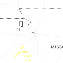
Mississippi
| Local Time | Report Details |
|---|---|
| 1:52 PM CDT | Hen Egg sized hail reported near Raymond, MS, 14.3 miles W of Jackson, MS, 2.25 in hail measured. |
| 2:05 PM CDT | Quarter sized hail reported near Clinton, MS, 8.7 miles W of Jackson, MS, amateur radio operator reported quarter size hail in clinton. |
| 3:10 AM CDT | Trees and powerpoles both snapped near strawberry hill on hwy 82... near the intersection of county rd 352. possible tornad in carroll county MS, 69.8 miles W of Starkville, MS |
| 3:10 AM CDT | Trees down on county road 313 in valley hill area. possible tornad in carroll county MS, 69.7 miles W of Starkville, MS |
| 3:18 AM CDT | Trees down on hwy 1 in carroll county MS, 65.1 miles W of Starkville, MS |
Wyoming
| Local Time | Report Details |
|---|---|
| 1:43 PM MDT | Muddy creek - 6970 ft in uinta county WY, 70 miles W of Rock Springs, WY |
Texas
| Local Time | Report Details |
|---|---|
| 2:55 PM CDT | Quarter sized hail reported near Mason, TX, 92.8 miles WSW of Killeen, TX, quarter size hail. |
| 3:10 PM CDT | Power line down. inactiv in mason county TX, 92.8 miles WSW of Killeen, TX |
| 4:48 PM CDT | Quarter sized hail reported near Santo, TX, 77.8 miles W of Dallas, TX, report from mping: quarter (1.00 in.). |
| 5:22 PM CDT | Quarter sized hail reported near Mineral Wells, TX, 74.8 miles W of Dallas, TX, quarter size hail in mineral wells via social media pictures. |
| 5:36 PM CDT | Quarter sized hail reported near Whitney, TX, 63.1 miles NNE of Killeen, TX, quarter size hail at juniper cove marina on lake whitney. |
| 5:40 PM CDT | Ping Pong Ball sized hail reported near Bridgeport, TX, 63.6 miles SSE of Wichita Falls, TX, ping pong ball size hail in joplin. |
| 5:40 PM CDT | Trees down in the 100 block of bonita driv in parker county TX, 58.4 miles WNW of Dallas, TX |
| 5:41 PM CDT | Tea Cup sized hail reported near Bridgeport, TX, 63.6 miles SSE of Wichita Falls, TX, stormchaser photo showed a hail stone approximately 3.25 inches long by 2.5 inches wide fell in joplin. |
| 5:41 PM CDT | Roof and awning damage on jefferson st. in whitne in hill county TX, 62.2 miles NNE of Killeen, TX |
| 5:42 PM CDT | 70 mph estimated winds in jopli in jack county TX, 63.4 miles SSE of Wichita Falls, TX |
| 5:45 PM CDT | Several facebook reports of numerous trees down in and around paradise with some outbuildings damage in wise county TX, 57.9 miles WNW of Dallas, TX |
| 5:50 PM CDT | Stormchaser video showed several trees blown down onto hwy 114 between bridgeport and paradis in wise county TX, 60.9 miles WNW of Dallas, TX |
| 5:53 PM CDT | Baseball sized hail reported near Bridgeport, TX, 62.8 miles SE of Wichita Falls, TX, baseball size hail just south of runaway bay. |
| 5:56 PM CDT | Ping Pong Ball sized hail reported near Bridgeport, TX, 62.7 miles SE of Wichita Falls, TX, report from mping. |
| 5:59 PM CDT | Quarter sized hail reported near Bridgeport, TX, 62.6 miles SE of Wichita Falls, TX, report from mping. |
| 6:21 PM CDT | Kdto asos 58k in denton county TX, 37.4 miles NW of Dallas, TX |
| 6:25 PM CDT | 60-65 mph winds estimated on fm922 at montague-cooke county line. tree damage and items blown aroun in cooke county TX, 64 miles NW of Dallas, TX |
| 6:31 PM CDT | Quarter sized hail reported near Muenster, TX, 66.9 miles ESE of Wichita Falls, TX, quarter size hail in muenster via em. |
| 6:38 PM CDT | Golf Ball sized hail reported near Muenster, TX, 66.9 miles ESE of Wichita Falls, TX, social media picture of golf ball hail in muenster. |
| 6:50 PM CDT | Half Dollar sized hail reported near Gainesville, TX, 72.1 miles E of Wichita Falls, TX, half dollar size hail at cr437 and cr408 in cooke county. |
| 7:10 PM CDT | 60 mph winds near and north of whitesboro. damage along hwy 377 at ferguson r in grayson county TX, 63.9 miles N of Dallas, TX |
| 7:24 PM CDT | Roof damage at a pharmacy and trees down along fm 120 in pottsbor in grayson county TX, 52.9 miles SW of Atoka, OK |
| 7:27 PM CDT | Many facebook reports of numerous trees down across denison with widespread power outage in grayson county TX, 49.8 miles SSW of Atoka, OK |
| 7:27 PM CDT | Public reports lots of tree limbs down on country road 431 via social medi in smith county TX, 79.4 miles E of Dallas, TX |
| 7:28 PM CDT | Trees down in the hoard community about 1 mile past fm road 1804. also... estimated hail up to quarter siz in wood county TX, 83.6 miles E of Dallas, TX |
| 8:15 PM CDT | Trees down near intersection of hwy 155 and fm road 268 in upshur county TX, 71.9 miles W of Shreveport, LA |
| 8:33 PM CDT | Numerous trees down from the novice community northeastward into red river count in lamar county TX, 59 miles SE of Atoka, OK |
| 8:48 PM CDT | Trees down on fm road 195 in manchester are in red river county TX, 67 miles SE of Atoka, OK |
| 9:00 PM CDT | Trees down on highway 37 just before the red rive in red river county TX, 68.3 miles W of Nashville, AR |
Pennsylvania
| Local Time | Report Details |
|---|---|
| 4:27 PM EDT | Tree down on roadwa in tioga county PA, 79.4 miles NNE of State College, PA |
| 4:46 PM EDT | Tree down on roadwa in tioga county PA, 75.2 miles WNW of Scranton, PA |
| 4:53 PM EDT | Several trees and wires down in the south creek townshi in bradford county PA, 70 miles NW of Scranton, PA |
Utah
| Local Time | Report Details |
|---|---|
| 2:55 PM MDT | Baker lab - 4294 ft in tooele county UT, 71.8 miles WSW of Salt Lake City, UT |
| 3:25 PM MDT | English village - 4788 ft in tooele county UT, 57.5 miles SW of Salt Lake City, UT |
| 3:50 PM MDT | Grantsville south - 4630 ft in tooele county UT, 34 miles WSW of Salt Lake City, UT |
| 4:46 PM MDT | Salt lake city intl airport asos - 4226 ft in salt lake county UT, 3.3 miles WNW of Salt Lake City, UT |
| 5:15 PM MDT | Vernon hill - 5761 ft in tooele county UT, 50.6 miles SSW of Salt Lake City, UT |
Arkansas
| Local Time | Report Details |
|---|---|
| 4:12 PM CDT | Hen Egg sized hail reported near Huttig, AR, 33.2 miles NW of Bastrop, LA, several photos of golf ball to 2 inch hail just to the east and southeast of the town of strong. |
| 4:28 PM CDT | Golf Ball sized hail reported near Strong, AR, 31.4 miles NW of Bastrop, LA, social media report of golf ball size hail about 6 miles east of the town of strong. |
| 8:36 PM CDT | Quarter sized hail reported near Arkadelphia, AR, 46.7 miles ENE of Nashville, AR |
| 4:31 AM CDT | Quarter sized hail reported near Fort Smith, AR, 3 miles SE of Fort Smith, AR, report from mping: quarter (1.00 in.). |
| 4:32 AM CDT | Corrects previous tstm wnd gst report from 3 wnw barling. reported at ft smith regional airpor in sebastian county AR, 4.6 miles SE of Fort Smith, AR |
| 4:32 AM CDT | Reported at ft smith regional airpor in sebastian county AR, 4.6 miles SE of Fort Smith, AR |
| 4:36 AM CDT | Also reported hail just under 1 inch in diameter at phoenix av in sebastian county AR, 3.5 miles SSE of Fort Smith, AR |
| 4:38 AM CDT | Several trees down on highway 96. time estimated from rada in sebastian county AR, 16.1 miles SE of Fort Smith, AR |
| 4:42 AM CDT | Signs blown down; intersection of zero st and hwy 4 in sebastian county AR, 4.2 miles SSE of Fort Smith, AR |
| 4:42 AM CDT | Signs blown dow in sebastian county AR, 4.2 miles SSE of Fort Smith, AR |
| 4:48 AM CDT | Quarter sized hail reported near Lavaca, AR, 14.5 miles ESE of Fort Smith, AR |
| 5:05 AM CDT | Trees down in this area with estimated max wind gust of 65 mp in logan county AR, 39.6 miles E of Fort Smith, AR |
| 5:20 AM CDT | Storm damage reported in logan county AR, 49.8 miles E of Fort Smith, AR |
| 5:20 AM CDT | Trees down and power outages noted west of clarksvill in johnson county AR, 51.8 miles E of Fort Smith, AR |
| 5:45 AM CDT | Trees down in the are in pope county AR, 61.2 miles NW of Little Rock, AR |
| 5:45 AM CDT | Trees down in this are in pope county AR, 65.7 miles NW of Little Rock, AR |
| 6:00 AM CDT | Quarter sized hail reported near Morrilton, AR, 39.4 miles NW of Little Rock, AR |
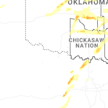
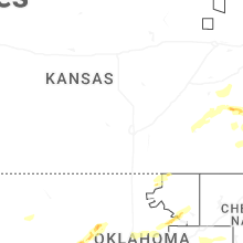
Oklahoma
| Local Time | Report Details |
|---|---|
| 4:26 PM CDT | Quarter sized hail reported near Chickasha, OK, 38.1 miles SW of Oklahoma City, OK |
| 4:45 PM CDT | Quarter sized hail reported near Tuttle, OK, 21.7 miles SW of Oklahoma City, OK, report from mping: quarter (1.00 in.). |
| 4:46 PM CDT | Quarter sized hail reported near Tuttle, OK, 20.6 miles SW of Oklahoma City, OK, report from mping: quarter (1.00 in.). |
| 4:48 PM CDT | Half Dollar sized hail reported near Lindsay, OK, 43.7 miles S of Oklahoma City, OK |
| 4:49 PM CDT | Half Dollar sized hail reported near Tuttle, OK, 18 miles SW of Oklahoma City, OK, report from mping: half dollar (1.25 in.). |
| 4:50 PM CDT | Golf Ball sized hail reported near Tuttle, OK, 18 miles SW of Oklahoma City, OK |
| 4:53 PM CDT | Baseball sized hail reported near Tuttle, OK, 18 miles SW of Oklahoma City, OK, report from mping: baseball (2.75 in.). |
| 4:56 PM CDT | Golf Ball sized hail reported near Mustang, OK, 13.3 miles WSW of Oklahoma City, OK, report from mping: golf ball (1.75 in.). |
| 4:59 PM CDT | Half Dollar sized hail reported near Mustang, OK, 13.3 miles WSW of Oklahoma City, OK, report from mping: half dollar (1.25 in.). |
| 5:02 PM CDT | Quarter sized hail reported near Maysville, OK, 41.3 miles S of Oklahoma City, OK, report from mping: quarter (1.00 in.). |
| 5:02 PM CDT | Hen Egg sized hail reported near Mustang, OK, 11.8 miles WSW of Oklahoma City, OK, report from mping: hen egg+ (2.25 in.). |
| 5:03 PM CDT | Baseball sized hail reported near Mustang, OK, 12.6 miles WSW of Oklahoma City, OK |
| 5:04 PM CDT | Half Dollar sized hail reported near Oklahoma City, OK, 9.2 miles WSW of Oklahoma City, OK, report from mping: half dollar (1.25 in.). |
| 5:04 PM CDT | Quarter sized hail reported near Yukon, OK, 13.1 miles W of Oklahoma City, OK |
| 5:05 PM CDT | Hen Egg sized hail reported near Yukon, OK, 11.1 miles WSW of Oklahoma City, OK, report from mping: hen egg (2.00 in.) delayed report estimated from radar. |
| 5:05 PM CDT | Ping Pong Ball sized hail reported near Yukon, OK, 10.4 miles WSW of Oklahoma City, OK |
| 5:05 PM CDT | Half Dollar sized hail reported near Oklahoma City, OK, 8 miles W of Oklahoma City, OK |
| 5:05 PM CDT | Ping Pong Ball sized hail reported near Mustang, OK, 15.4 miles WSW of Oklahoma City, OK, report from mping: ping pong ball (1.50 in.). |
| 5:10 PM CDT | Quarter sized hail reported near Tuttle, OK, 16.3 miles SW of Oklahoma City, OK |
| 5:11 PM CDT | Half Dollar sized hail reported near Mustang, OK, 11.3 miles WSW of Oklahoma City, OK, report from mping: half dollar (1.25 in.). |
| 5:12 PM CDT | Hen Egg sized hail reported near Oklahoma City, OK, 5.2 miles WNW of Oklahoma City, OK, report from mping: hen egg+ (2.25 in.) deleyed report... estimated from radar. |
| 6:44 PM CDT | Quarter sized hail reported near Ada, OK, 46.4 miles NW of Atoka, OK, report from mping: quarter (1.00 in.). |
| 6:50 PM CDT | Quarter sized hail reported near Ada, OK, 39.8 miles NW of Atoka, OK, report from mping: quarter (1.00 in.) delayed report... estimated from radar. |
| 7:55 PM CDT | Quarter sized hail reported near Pittsburg, OK, 20.2 miles NNE of Atoka, OK, report from mping: quarter (1.00 in.). |
| 7:57 PM CDT | Golf Ball sized hail reported near Wardville, OK, 19 miles NNE of Atoka, OK |
| 7:57 PM CDT | Storm damage reported in atoka county OK, 19 miles NNE of Atoka, OK |
| 9:30 PM CDT | Half Dollar sized hail reported near Oklahoma City, OK, 6.2 miles W of Oklahoma City, OK |
| 9:33 PM CDT | Golf Ball sized hail reported near Oklahoma City, OK, 5.2 miles WNW of Oklahoma City, OK |
| 9:38 PM CDT | Corrects previous tstm wnd gst report from 6 sw oklahoma cit in oklahoma county OK, 5.8 miles SW of Oklahoma City, OK |
| 9:51 PM CDT | Quarter sized hail reported near Oklahoma City, OK, 7.6 miles SE of Oklahoma City, OK |
| 9:52 PM CDT | Storm damage reported in oklahoma county OK, 5.8 miles SW of Oklahoma City, OK |
| 9:54 PM CDT | Quarter sized hail reported near Oklahoma City, OK, 7.1 miles SE of Oklahoma City, OK |
| 9:54 PM CDT | Half Dollar sized hail reported near Oklahoma City, OK, 7.2 miles ESE of Oklahoma City, OK |
| 9:58 PM CDT | Quarter sized hail reported near Oklahoma City, OK, 7.1 miles ESE of Oklahoma City, OK |
| 10:10 PM CDT | Quarter sized hail reported near Choctaw, OK, 12.8 miles ESE of Oklahoma City, OK |
| 10:22 PM CDT | Grapefruit sized hail reported near Newalla, OK, 18.6 miles ESE of Oklahoma City, OK, near i-40 and peebly road. |
| 10:35 PM CDT | Hen Egg sized hail reported near Shawnee, OK, 26.7 miles ESE of Oklahoma City, OK |
| 10:42 PM CDT | Quarter sized hail reported near Jennings, OK, 36.6 miles W of Tulsa, OK, report from mping: quarter (1.00 in.). |
| 10:59 PM CDT | Ping Pong Ball sized hail reported near Cleveland, OK, 29.3 miles WNW of Tulsa, OK |
| 11:01 PM CDT | Golf Ball sized hail reported near Cleveland, OK, 28.8 miles WNW of Tulsa, OK |
| 11:08 PM CDT | Golf Ball sized hail reported near Hominy, OK, 25.6 miles WNW of Tulsa, OK, report from mping: golf ball (1.75 in.). |
| 1:30 AM CDT | Quarter sized hail reported near Oklahoma City, OK, 6.8 miles E of Oklahoma City, OK, report from mping: quarter (1.00 in.). time adjusted based on radar. |
| 1:30 AM CDT | Half Dollar sized hail reported near Oklahoma City, OK, 7.4 miles E of Oklahoma City, OK, report from mping: half dollar (1.25 in.). time adjusted based on radar. |
| 1:35 AM CDT | Quarter sized hail reported near Oklahoma City, OK, 5.9 miles ESE of Oklahoma City, OK, phone call report. |
| 2:50 AM CDT | Multiple trees down on sharp rd between okmulgee and wilson rd intersection sw of town. time estimated by rada in okmulgee county OK, 37.9 miles S of Tulsa, OK |
| 2:53 AM CDT | Quarter sized hail reported near Henryetta, OK, 46.7 miles SSE of Tulsa, OK, time estimated by radar. |
| 2:55 AM CDT | Storm damage reported in okmulgee county OK, 39.6 miles S of Tulsa, OK |
| 3:03 AM CDT | Quarter sized hail reported near Henryetta, OK, 44.9 miles S of Tulsa, OK, hwy 266 & 300 rd; time estimated by radar. |
| 3:22 AM CDT | Quarter sized hail reported near Checotah, OK, 53.9 miles SSE of Tulsa, OK, 55 mph winds also reported. |
| 3:39 AM CDT | Storm damage reported in muskogee county OK, 42.2 miles WNW of Fort Smith, AR |
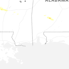
Louisiana
| Local Time | Report Details |
|---|---|
| 4:30 PM CDT | 1 large tree blew down across highway 17... which blocked traffic and needed to be remove in west carroll county LA, 33.4 miles ENE of Bastrop, LA |
Massachusetts
| Local Time | Report Details |
|---|---|
| 6:10 PM EDT | Report of a tree down near may terrace in pittsfiel in berkshire county MA, 44.4 miles SE of Schenectady, NY |
| 6:12 PM EDT | Report of wires down and arching near the intersection of washington mt road and kirchner roa in berkshire county MA, 46.1 miles SE of Schenectady, NY |
| 6:16 PM EDT | Tree and wire down along strong avenue in the city of pittsfiel in berkshire county MA, 44.4 miles SE of Schenectady, NY |
| 6:16 PM EDT | Tree down on a wire along putnam avenue in the city of pittsfiel in berkshire county MA, 44.4 miles SE of Schenectady, NY |
| 6:17 PM EDT | Several trees were down along may terrace in pittsfiel in berkshire county MA, 44.4 miles SE of Schenectady, NY |
| 6:17 PM EDT | Tree down on a wire along putnam avenue in the city of pittsfiel in berkshire county MA, 44.4 miles SE of Schenectady, NY |
| 6:18 PM EDT | Several trees were down along may terrace in pittsfiel in berkshire county MA, 44.4 miles SE of Schenectady, NY |
| 6:18 PM EDT | Report of wires down and arching near the intersection of washington mt road and kirchner roa in berkshire county MA, 46.1 miles SE of Schenectady, NY |
| 7:07 PM EDT | Quarter sized hail reported near Williamsburg, MA, 68.3 miles ESE of Schenectady, NY |
| 7:10 PM EDT | Wires and utility pole down on mountain street at laural roa in hampshire county MA, 68.5 miles ESE of Schenectady, NY |
| 7:18 PM EDT | Tree down along the 100 block of maple street in greenfield. relayed by amateur radi in franklin county MA, 70 miles ESE of Schenectady, NY |
| 7:30 PM EDT | Reported tree down on wires on school street and on hill stree in hampshire county MA, 72.2 miles WNW of Providence, RI |
New Hampshire
| Local Time | Report Details |
|---|---|
| 6:10 PM EDT | Lebanon fire reporting multiple trees down blocking butternut ln. time estimated by rada in grafton county NH, 72.9 miles SE of Burlington, VT |
| 6:10 PM EDT | Trees down on south side of lebanon (trues brook and hall rd). time estimated by rada in grafton county NH, 74.5 miles SE of Burlington, VT |
| 6:15 PM EDT | Quarter sized hail reported near Lebanon, NH, 74.7 miles SE of Burlington, VT, spotter reporting quarter size hail in lebanon. |
| 6:15 PM EDT | Ping Pong Ball sized hail reported near West Lebanon, NH, 72.6 miles SE of Burlington, VT, spotter reported hail up to ping pong ball size in west lebanon. |
| 6:25 PM EDT | Trees down blocking nh-120 north bound in the area of methodist hill rd in plainfiel in sullivan county NH, 79.2 miles SE of Burlington, VT |
| 6:25 PM EDT | Trees and branches downed. pillsbury street partially blocked by 10 inch diameter tree. time estimated by rada in grafton county NH, 78.6 miles SE of Burlington, VT |
| 6:28 PM EDT | Half Dollar sized hail reported near Enfield, NH, 78.3 miles SE of Burlington, VT, spotter reporting half dollar size hail on rt. 4 in enfield. |
| 6:32 PM EDT | Quarter sized hail reported near Enfield, NH, 79.7 miles SE of Burlington, VT, spotter reported quarter size hail near canaan town line. |
| 6:40 PM EDT | Tree down partially obstructing westbound lane of us hwy 4. time estimated by rada in grafton county NH, 82.3 miles SE of Burlington, VT |
Nevada
| Local Time | Report Details |
|---|---|
| 5:15 PM PDT | Arl sord area 12 camp. peak gust generated by thunderstor in nye county NV, 90.7 miles NW of Las Vegas, NV |
| 5:45 PM PDT | Mesonet station a05ab 13.2 n mercury (arl sord). gust generated by thunderstor in nye county NV, 65 miles NW of Las Vegas, NV |
| 6:30 PM PDT | Mesonet station a05ab 13.2 n mercury (arl sord). thunderstorm generated gus in nye county NV, 65 miles NW of Las Vegas, NV |
| 6:45 PM PDT | Peak gust at mesonet station a27ab sord station 33. thunderstorm generate in nye county NV, 68.8 miles NW of Las Vegas, NV |
| 7:00 PM PDT | Arl sord station 28. peak gust generated by thunderstor in nye county NV, 70.9 miles NW of Las Vegas, NV |
| 8:53 PM PDT | Awos station kvgt north las vegas airport. wind gust associated with thunderstorm outflo in clark county NV, 4.7 miles NW of Las Vegas, NV |
Arizona
| Local Time | Report Details |
|---|---|
| 9:33 PM MST | Peak gust at mesonet station qtwa3 tweeds point. single gust over 58 mph associated with thunderstorm outflo in mohave county AZ, 37.4 miles SSW of Saint George, UT |
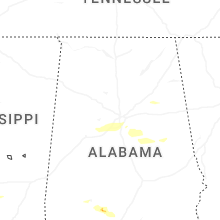
Alabama
| Local Time | Report Details |
|---|---|
| 6:02 AM CDT | Half Dollar sized hail reported near Birmingham, AL, 7.6 miles S of Birmingham, AL, broadcast media relayed public photo of hail near hoover. |
| 6:02 AM CDT | Half Dollar sized hail reported near Birmingham, AL, 12.6 miles S of Birmingham, AL, public report of quarter size hail via social media. |
| 6:04 AM CDT | Quarter sized hail reported near Birmingham, AL, 13.7 miles SSW of Birmingham, AL |
| 6:08 AM CDT | Tree fell on a house along with several trees down in the area per trained spotter relaying scanner traffi in jefferson county AL, 5 miles SSE of Birmingham, AL |
| 6:08 AM CDT | Corrects previous hail report from 3 sw bull city. numerous trees reported down along lock 17 road according to antioch fd... report relayed by trained spotte in tuscaloosa county AL, 29.6 miles WSW of Birmingham, AL |
| 6:08 AM CDT | Half Dollar sized hail reported near Brookwood, AL, 29.6 miles WSW of Birmingham, AL, numerous trees reported down along lock 17 road according to antioch fd... report relayed by trained spotter. |
| 6:09 AM CDT | Half Dollar sized hail reported near Pelham, AL, 12 miles SSE of Birmingham, AL |
| 6:14 AM CDT | Report of power lines down near the intersection of old leeds road and cherokee road... mountain brook fd respondin in jefferson county AL, 5.1 miles ESE of Birmingham, AL |
| 11:38 AM UTC | Vestavia hills fd responding to report of a tree that fell on a home and damaged the front porc in jefferson county AL, 6.9 miles S of Birmingham, AL |
| 11:38 AM UTC | Power lines down near the intersection of benjamin drive and smokey road in alabaste in shelby county AL, 23.5 miles S of Birmingham, AL |
| 11:45 AM UTC | Tree down across highway 491 bear creek roa in shelby county AL, 14.5 miles SE of Birmingham, AL |
Connect with Interactive Hail Maps