

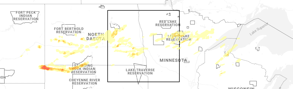
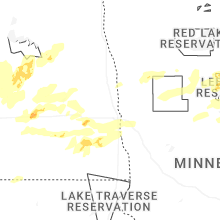
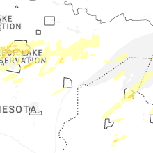
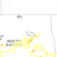
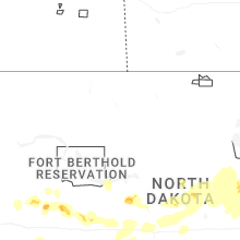
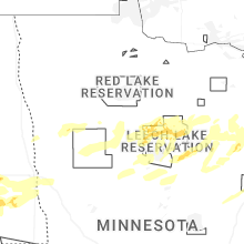
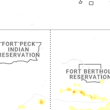
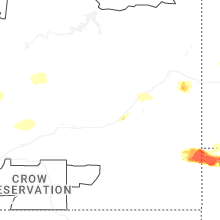
Hail Map for Friday, June 20, 2025
Number of Impacted Households on 6/20/2025
0
Impacted by 1" or Larger Hail
0
Impacted by 1.75" or Larger Hail
0
Impacted by 2.5" or Larger Hail
Square Miles of Populated Area Impacted on 6/20/2025
0
Impacted by 1" or Larger Hail
0
Impacted by 1.75" or Larger Hail
0
Impacted by 2.5" or Larger Hail

Cities Most Affected by Hail Storms of 6/20/2025
| Hail Size | Demographics of Zip Codes Affected | ||||||
|---|---|---|---|---|---|---|---|
| City | Count | Average | Largest | Pop Density | House Value | Income | Age |
| Buffalo, SD | 6 | 3.08 | 3.60 | 0 | $50k | $25.3k | 43.2 |
| Jamestown, ND | 5 | 2.45 | 3.00 | 39 | $71k | $33.6k | 42.3 |
| Ekalaka, MT | 3 | 2.33 | 2.50 | 0 | $23k | $25.4k | 50.1 |
| Grand Rapids, MN | 1 | 3.00 | 3.00 | 82 | $90k | $37.4k | 44.5 |
| Broadus, MT | 1 | 2.50 | 2.50 | 0 | $58k | $27.8k | 49.9 |
| Prairie City, SD | 1 | 2.50 | 2.50 | 0 | $34k | $29.0k | 43.3 |
| Marion, ND | 1 | 2.00 | 2.00 | 2 | $26k | $25.4k | 50.4 |
| Baker, MT | 1 | 2.00 | 2.00 | 0 | $49k | $30.7k | 42.1 |
| Lodgepole, SD | 1 | 1.85 | 1.85 | 0 | $31k | $28.1k | 53.4 |
| Camp Crook, SD | 1 | 1.75 | 1.75 | 0 | $44k | $25.5k | 41.5 |
Hail and Wind Damage Spotted on 6/20/2025
Filter by Report Type:Hail ReportsWind Reports
States Impacted
Iowa, Montana, Florida, Nebraska, Oregon, South Dakota, North Dakota, Kansas, MinnesotaIowa
| Local Time | Report Details |
|---|---|
| 8:08 AM CDT | Tree limbs dow in grundy county IA, 58.6 miles SSE of Mason City, IA |
| 8:20 AM CDT | Report of large tree split and large branches downed in reinbec in grundy county IA, 53.2 miles WNW of Cedar Rapids, IA |
| 8:53 AM CDT | Asos station kmiw marshalltown airpor in marshall county IA, 51.3 miles NE of Des Moines, IA |
| 8:59 AM CDT | Tree damage with limbs dow in marshall county IA, 48.3 miles NE of Des Moines, IA |
| 9:03 AM CDT | Multiple tree limbs dow in tama county IA, 45.8 miles WNW of Cedar Rapids, IA |
| 10:55 AM CDT | Delayed report... relayed by media of large branches downed in pell in marion county IA, 38.2 miles ESE of Des Moines, IA |
| 11:20 AM CDT | Medium sized tree split with lots of other trees damaged. time estimated from rada in mahaska county IA, 59.6 miles ESE of Des Moines, IA |
| 11:35 AM CDT | Large tree down... which also knocked down power line in monroe county IA, 48.1 miles SE of Des Moines, IA |
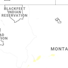
Montana
| Local Time | Report Details |
|---|---|
| 12:38 PM MDT | Time estimated from rada in yellowstone county MT, 3.7 miles E of Billings, MT |
| 1:21 PM MDT | Mesonet station sdam8 soda spring in yellowstone county MT, 6.3 miles SE of Billings, MT |
| 3:37 PM MDT | Quarter sized hail reported near Miles City, MT, 0.5 miles ENE of Miles City, MT, facebook report. |
| 3:38 PM MDT | Half Dollar sized hail reported near Miles City, MT, 2.2 miles ESE of Miles City, MT |
| 3:45 PM MDT | Quarter sized hail reported near Miles City, MT, 1.8 miles SE of Miles City, MT, report from mping: quarter (1.00 in.). |
| 4:15 PM MDT | Tennis Ball sized hail reported near Broadus, MT, 57.9 miles SE of Miles City, MT, facebook report. |
| 4:45 PM MDT | Tennis Ball sized hail reported near Ekalaka, MT, 71.8 miles ESE of Miles City, MT, facebook report. |
| 4:56 PM MDT | Hen Egg sized hail reported near Ekalaka, MT, 71.8 miles ESE of Miles City, MT |
| 5:20 PM MDT | Tennis Ball sized hail reported near Ekalaka, MT, 86.3 miles ESE of Miles City, MT |
| 5:30 PM MDT | Hen Egg sized hail reported near Baker, MT, 90.8 miles ESE of Miles City, MT, facebook report. |
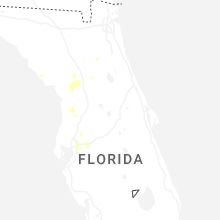
Florida
| Local Time | Report Details |
|---|---|
| 5:30 PM EDT | County dispatch reported trees down along county road 316. the time of damage was based on rada in marion county FL, 67.7 miles NNW of Orlando, FL |
| 5:34 PM EDT | Power line down in suwanne in dixie county FL, 102.6 miles SE of Tallahassee, FL |
| 6:30 PM EDT | County dispatch reported trees down near highway 326. the time of damage was based on rada in marion county FL, 76.6 miles NW of Orlando, FL |
| 6:55 PM EDT | Emergency management reported power lines were blown down near silver lake drive and carnation stree in putnam county FL, 48.2 miles SSW of Jacksonville, FL |
Nebraska
| Local Time | Report Details |
|---|---|
| 4:50 PM CDT | An area of showers/virga led to a report of a flipped pivot in a field. time and exact location was relayed to us by the spotte in hitchcock county NE, 56.7 miles NNW of Colby, KS |
Oregon
| Local Time | Report Details |
|---|---|
| 3:50 PM PDT | Approximately 4 inch branches snapped from a conifer tre in multnomah county OR, 4.6 miles NNW of Portland, OR |
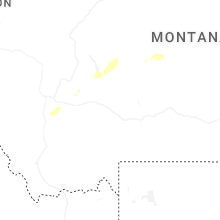
South Dakota
| Local Time | Report Details |
|---|---|
| 5:42 PM MDT | Golf Ball sized hail reported near Camp Crook, SD, 101.6 miles ESE of Miles City, MT |
| 5:51 PM MDT | Quarter sized hail reported near Camp Crook, SD, 105.3 miles ESE of Miles City, MT |
| 5:51 PM MDT | Storm damage reported in harding county SD, 105.3 miles ESE of Miles City, MT |
| 5:55 PM MDT | Storm damage reported in harding county SD, 109.7 miles ESE of Miles City, MT |
| 6:05 PM MDT | Tea Cup sized hail reported near Buffalo, SD, 113.4 miles N of Rapid City, SD |
| 6:08 PM MDT | Tennis Ball sized hail reported near Buffalo, SD, 112.3 miles N of Rapid City, SD |
| 6:09 PM MDT | Storm damage reported in harding county SD, 106 miles N of Rapid City, SD |
| 6:11 PM MDT | Tea Cup sized hail reported near Buffalo, SD, 114.5 miles N of Rapid City, SD, broken hailstone of 3.6 inch measured. corrected for size... time... and more precise location. |
| 6:13 PM MDT | Tea Cup sized hail reported near Buffalo, SD, 113.7 miles N of Rapid City, SD |
| 6:20 PM MDT | Tea Cup sized hail reported near Buffalo, SD, 114.4 miles N of Rapid City, SD, several 3.1 inch diameter hail stones. corrected for size. |
| 6:20 PM MDT | Storm damage reported in harding county SD, 124 miles ESE of Miles City, MT |
| 6:20 PM MDT | Tea Cup sized hail reported near Buffalo, SD, 114.4 miles N of Rapid City, SD, several 3.1 inch diameter hail stones. |
| 6:46 PM MDT | Tennis Ball sized hail reported near Prairie City, SD, 110.3 miles N of Rapid City, SD |
| 7:06 PM MDT | Golf Ball sized hail reported near Lodgepole, SD, 110.8 miles NNE of Rapid City, SD |
| 7:06 PM MDT | Ping Pong Ball sized hail reported near Lodgepole, SD, 110.8 miles NNE of Rapid City, SD |
| 7:07 PM MDT | Quarter sized hail reported near Lodgepole, SD, 113.4 miles NNE of Rapid City, SD |
| 7:07 PM MDT | Half Dollar sized hail reported near Lodgepole, SD, 112.7 miles NNE of Rapid City, SD |
| 7:10 PM MDT | Storm damage reported in perkins county SD, 104.2 miles NNE of Rapid City, SD |
| 7:14 PM MDT | Storm damage reported in perkins county SD, 113 miles SW of Bismarck, ND |
| 7:20 PM MDT | Storm damage reported in perkins county SD, 91.7 miles SW of Bismarck, ND |
| 7:25 PM MDT | Half Dollar sized hail reported near Lemmon, SD, 111.3 miles SW of Bismarck, ND |
| 7:33 PM MDT | Storm damage reported in perkins county SD, 102.9 miles SW of Bismarck, ND |
| 7:35 PM MDT | Half Dollar sized hail reported near Lodgepole, SD, 114.6 miles NNE of Rapid City, SD |
| 8:15 PM MDT | Storm damage reported in corson county SD, 67 miles SSW of Bismarck, ND |
| 8:32 PM MDT | Trained spotter estimates 60 miles per hour west of mclaughlin. time estimated based on rada in corson county SD, 67 miles S of Bismarck, ND |
| 8:35 PM MDT | Mesonet station 205 mclaughlin (sddot in corson county SD, 66.3 miles S of Bismarck, ND |
| 10:05 PM CDT | Thunderstorm outflow winds. mesonet station 50 herreid (sddot in campbell county SD, 73 miles SSE of Bismarck, ND |
| 10:26 PM CDT | Corrects previous tstm wnd gst report remarks from 10 w long lake to add thunderstorm outflow winds. time based on radar. sand lake raw in mcpherson county SD, 53.3 miles WNW of Aberdeen, SD |
North Dakota
| Local Time | Report Details |
|---|---|
| 5:55 PM MDT | Quarter sized hail reported near Fairfield, ND, 70.8 miles SSE of Williston, ND |
| 6:30 PM MDT | Storm damage reported in slope county ND, 107.5 miles WSW of Bismarck, ND |
| 6:42 PM MDT | Asos station kdik dickinson airpor in stark county ND, 95.9 miles W of Bismarck, ND |
| 7:50 PM CDT | Ping Pong Ball sized hail reported near Jamestown, ND, 83.3 miles S of Devils Lake, ND |
| 7:51 PM CDT | Quarter sized hail reported near Jamestown, ND, 86.1 miles S of Devils Lake, ND, report from mping: quarter (1.00 in.). |
| 6:53 PM MDT | Asos station khei hettinger airpor in adams county ND, 104.6 miles WSW of Bismarck, ND |
| 6:55 PM MDT | Weather statio in hettinger county ND, 85.3 miles W of Bismarck, ND |
| 7:59 PM CDT | Hen Egg sized hail reported near Jamestown, ND, 84.1 miles S of Devils Lake, ND, report from mping: hen egg (2.00 in.). |
| 8:00 PM CDT | Golf Ball sized hail reported near Jamestown, ND, 83.3 miles S of Devils Lake, ND, hail still ongoing. damage to car windshield. |
| 8:05 PM CDT | Tennis Ball sized hail reported near Jamestown, ND, 83.3 miles S of Devils Lake, ND, ongoing at time of report. |
| 7:05 PM MDT | 10m wind gust mott 1n ndawn statio in hettinger county ND, 79 miles WSW of Bismarck, ND |
| 8:07 PM CDT | Tea Cup sized hail reported near Jamestown, ND, 84.1 miles S of Devils Lake, ND, report from mping: tea cup (3.00 in.). |
| 7:17 PM MDT | 10 meter wind gust ndawn elgin 10n in grant county ND, 61.3 miles WSW of Bismarck, ND |
| 7:25 PM MDT | 10 meter measured wind gust ndawn pretty rock 2 in grant county ND, 65 miles SW of Bismarck, ND |
| 8:25 PM CDT | Tea Cup sized hail reported near Jamestown, ND, 81.3 miles S of Devils Lake, ND, public phone call. picture also sent vis email. |
| 7:40 PM MDT | 10 meter measured wind gust ndawn carson 9en in grant county ND, 37.8 miles SW of Bismarck, ND |
| 8:47 PM CDT | 10 meter measured gust ndawn station new salem 6n in morton county ND, 26.7 miles W of Bismarck, ND |
| 9:05 PM CDT | Large evergreen tree blown over near rosser ave and 26th stree in burleigh county ND, 1.4 miles ENE of Bismarck, ND |
| 9:07 PM CDT | Weather station. also reported 1.31 inches of rai in morton county ND, 5.7 miles WNW of Bismarck, ND |
| 9:10 PM CDT | Measured wind gust from bismarck i-94 bridge nddot sit in burleigh county ND, 2.6 miles WNW of Bismarck, ND |
| 9:15 PM CDT | Awos station ky19 manda in morton county ND, 6.2 miles WSW of Bismarck, ND |
| 9:15 PM CDT | Tree limbs down in hillview are in burleigh county ND, 0.3 miles N of Bismarck, ND |
| 9:17 PM CDT | 10 meter measured gust ndawn sanger 1 in oliver county ND, 27.1 miles NNW of Bismarck, ND |
| 9:18 PM CDT | Mesonet station cw2059 6 n bismarc in burleigh county ND, 6.6 miles N of Bismarck, ND |
| 9:19 PM CDT | Asos station kbis bismarck airpor in burleigh county ND, 2.8 miles SSE of Bismarck, ND |
| 9:20 PM CDT | 10 meter wind gust ndawn livona 5 in emmons county ND, 27.1 miles SSE of Bismarck, ND |
| 9:20 PM CDT | Hen Egg sized hail reported near Marion, ND, 75.8 miles WSW of Fargo, ND, large hail during tornado warned storm. |
| 9:30 PM CDT | Fort yates nddot station measured wind gus in sioux county ND, 37.6 miles S of Bismarck, ND |
| 9:35 PM CDT | 10 meter measured wind gust ndawn 5nw linto in emmons county ND, 40.5 miles SE of Bismarck, ND |
| 9:40 PM CDT | 10 meter measured gust ndawn 5nw linto in emmons county ND, 40.5 miles SE of Bismarck, ND |
| 9:40 PM CDT | Hazelton nddot site measured wind gus in emmons county ND, 31 miles SE of Bismarck, ND |
| 10:00 PM CDT | 10 meter measured wind gust robinson 3nn in kidder county ND, 52.7 miles ENE of Bismarck, ND |
| 10:00 PM CDT | 10 meter measured wind gust ndawn wishek 5 in mcintosh county ND, 64.9 miles SE of Bismarck, ND |
| 10:03 PM CDT | 10 meter measured wind gust ndawn streeter 6n in kidder county ND, 62.9 miles E of Bismarck, ND |
| 10:04 PM CDT | 10 meter measured wind gust ndawn tappen 3 in kidder county ND, 57.1 miles E of Bismarck, ND |
| 10:13 PM CDT | 10 meter measured wind gust ndawn 8n win in burleigh county ND, 38.5 miles NNE of Bismarck, ND |
| 10:32 PM CDT | 10 meter measured gust ndawn 8n win in burleigh county ND, 38.5 miles NNE of Bismarck, ND |
| 10:34 PM CDT | 10 meter measured gust ndawn 1s ju in lamoure county ND, 75.8 miles NNW of Aberdeen, SD |
| 10:58 PM CDT | 10 meter measured gust ndawn 3nnw robinso in kidder county ND, 52.7 miles ENE of Bismarck, ND |
| 11:05 PM CDT | Storm damage reported in lamoure county ND, 62.9 miles N of Aberdeen, SD |
| 11:10 PM CDT | Nd dot sensor observatio in foster county ND, 47.3 miles SSE of Devils Lake, ND |
| 11:14 PM CDT | Tree branches 6 inches to 10 inches in diameter were reported down in valley cit in barnes county ND, 58.2 miles W of Fargo, ND |
| 11:25 PM CDT | 10 meter measured gust ndawn 2ne woodwort in stutsman county ND, 69.2 miles SSW of Devils Lake, ND |
| 11:29 PM CDT | 10 meter measured gust ndawn 5nw steel in kidder county ND, 37.8 miles E of Bismarck, ND |
| 11:31 PM CDT | Quarter sized hail reported near Wheatland, ND, 27.9 miles WSW of Fargo, ND |
| 11:43 PM CDT | 10 meter measured gust ndawn 3e tappe in kidder county ND, 57.1 miles E of Bismarck, ND |
| 11:56 PM CDT | 10 meter measured gust ndawn 1s heato in wells county ND, 55.1 miles SW of Devils Lake, ND |
| 12:21 AM CDT | 10 meter measured gust ndawn 5w courtena in stutsman county ND, 62.2 miles S of Devils Lake, ND |
Kansas
| Local Time | Report Details |
|---|---|
| 7:48 PM MDT | Wunderground site kkssharo30 reported the gust associated with outflow from decaying stor in wallace county KS, 48.7 miles SW of Colby, KS |
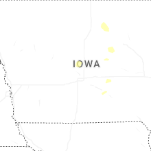
Minnesota
| Local Time | Report Details |
|---|---|
| 11:46 PM CDT | Tea Cup sized hail reported near Grand Rapids, MN, 67.2 miles WNW of Duluth, MN |
| 12:06 AM CDT | Quarter sized hail reported near Remer, MN, 44 miles SE of Bemidji, MN |
| 12:26 AM CDT | Quarter sized hail reported near Meadowlands, MN, 43.7 miles NW of Duluth, MN |
| 12:50 AM CDT | There were reports of multiple branches down... power flashes... and home damage. winds were estimated at 80 mp in beltrami county MN, 0.5 miles N of Bemidji, MN |
| 1:15 AM CDT | There were reports of power lines down and tree limbs up to 3 inches dow in polk county MN, 45.2 miles N of Fargo, ND |
Connect with Interactive Hail Maps