

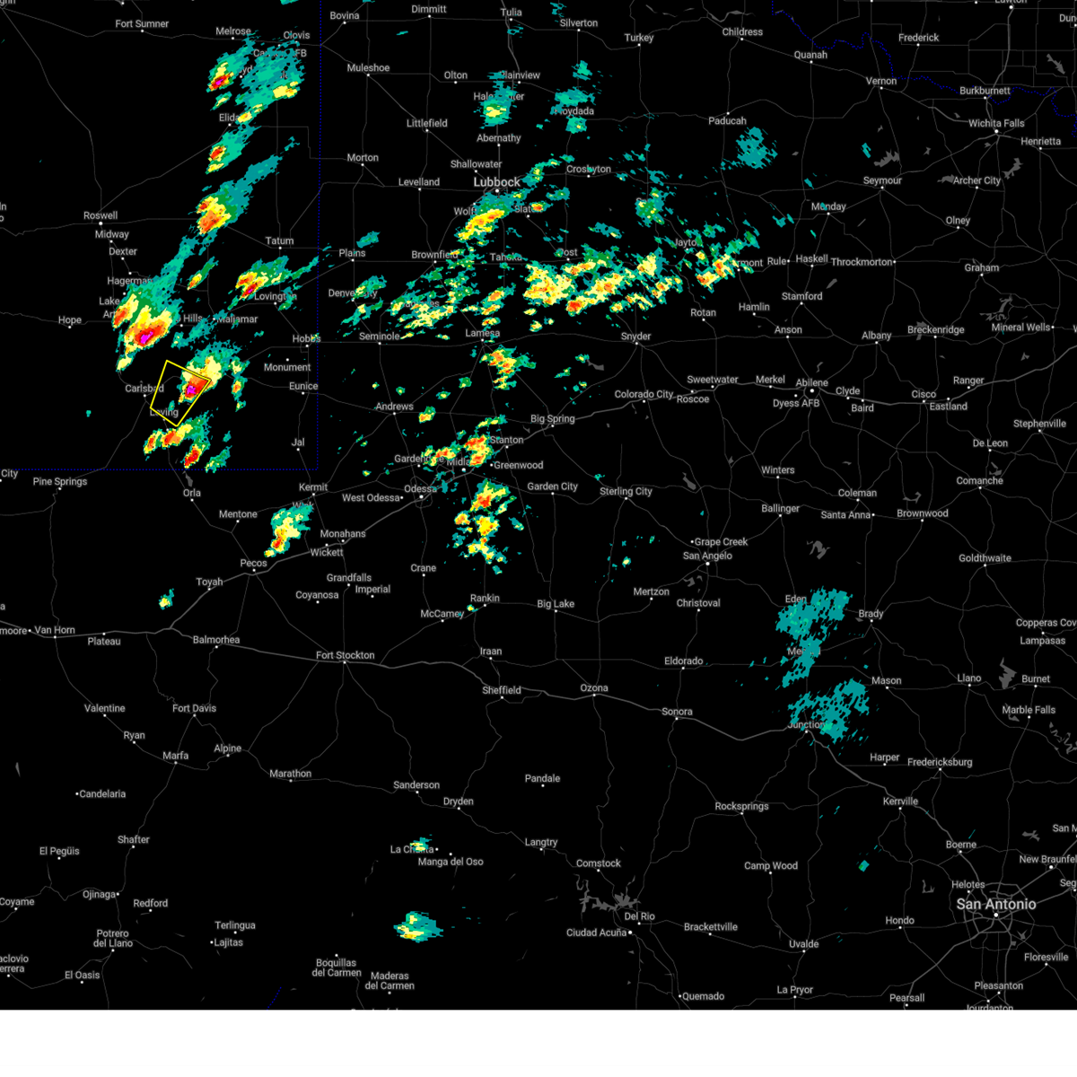
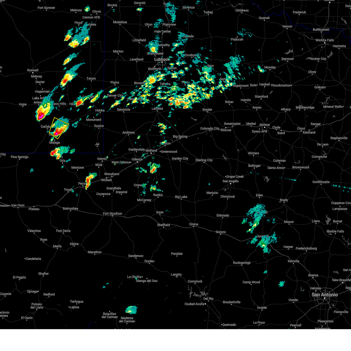
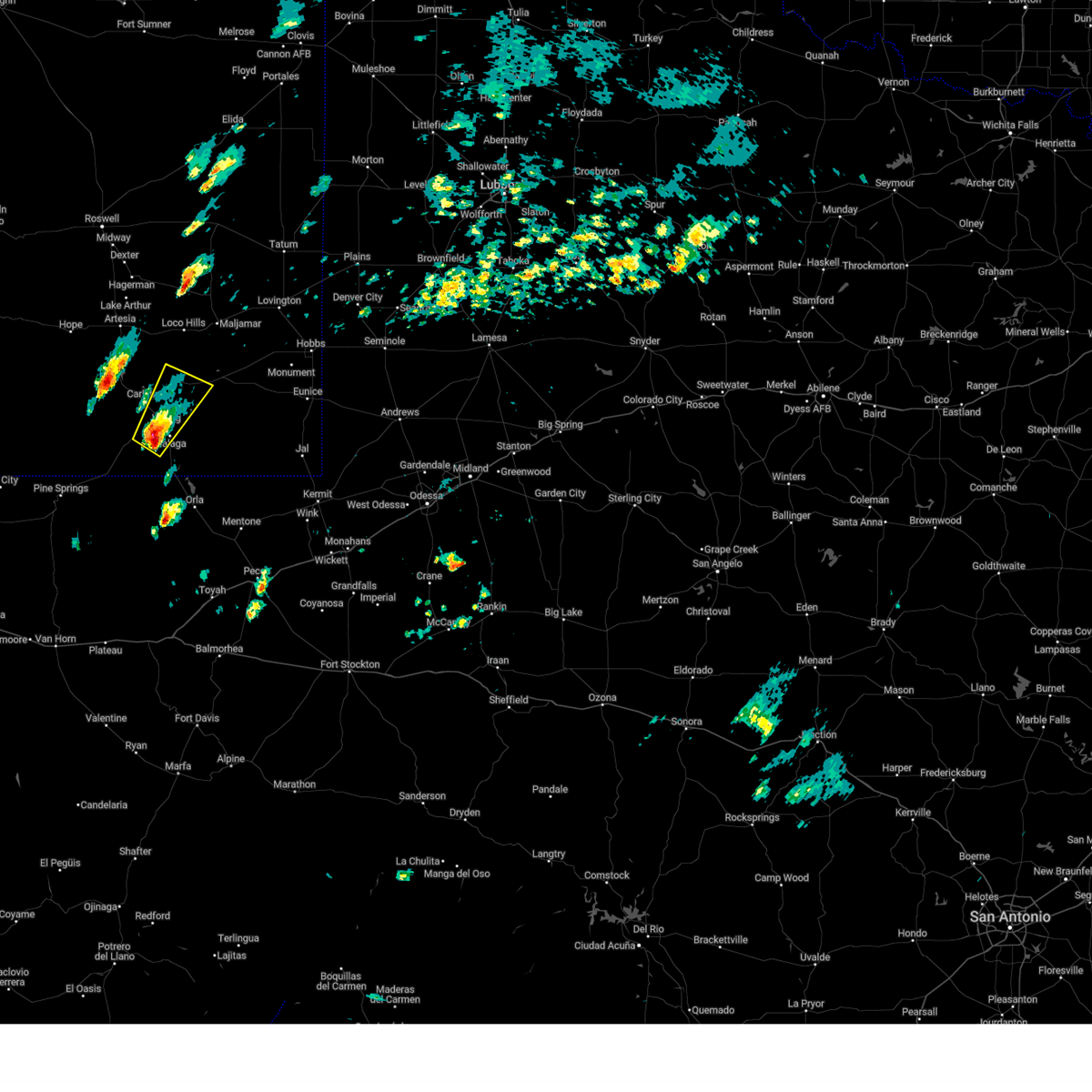
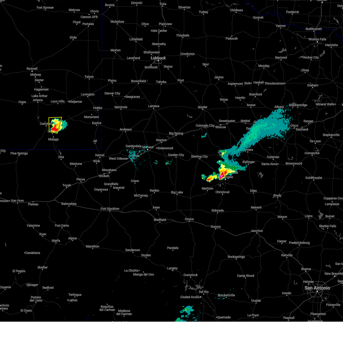
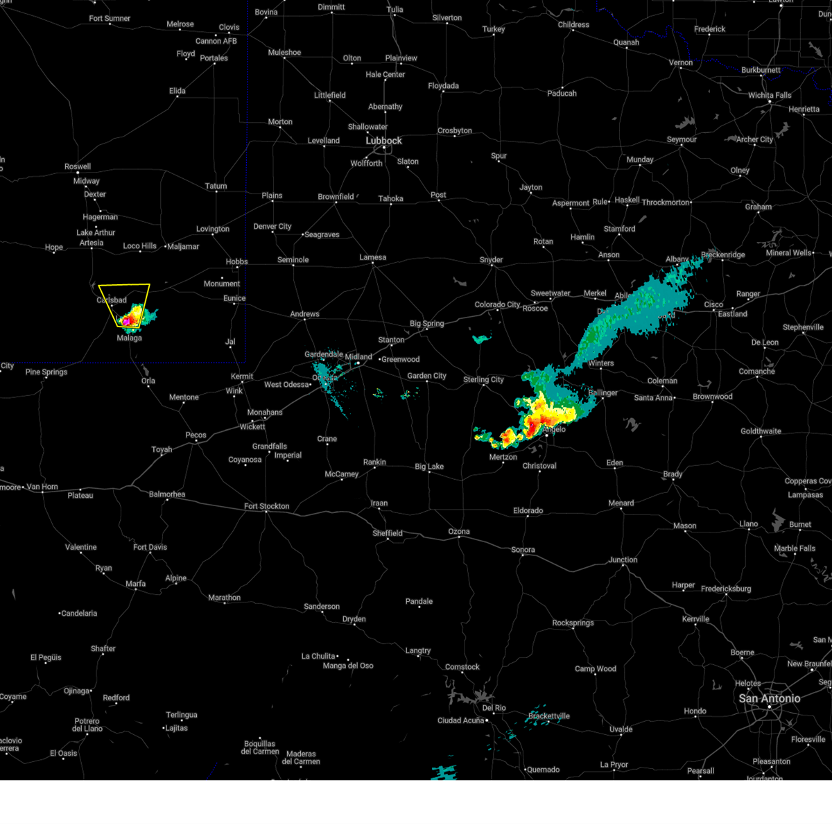
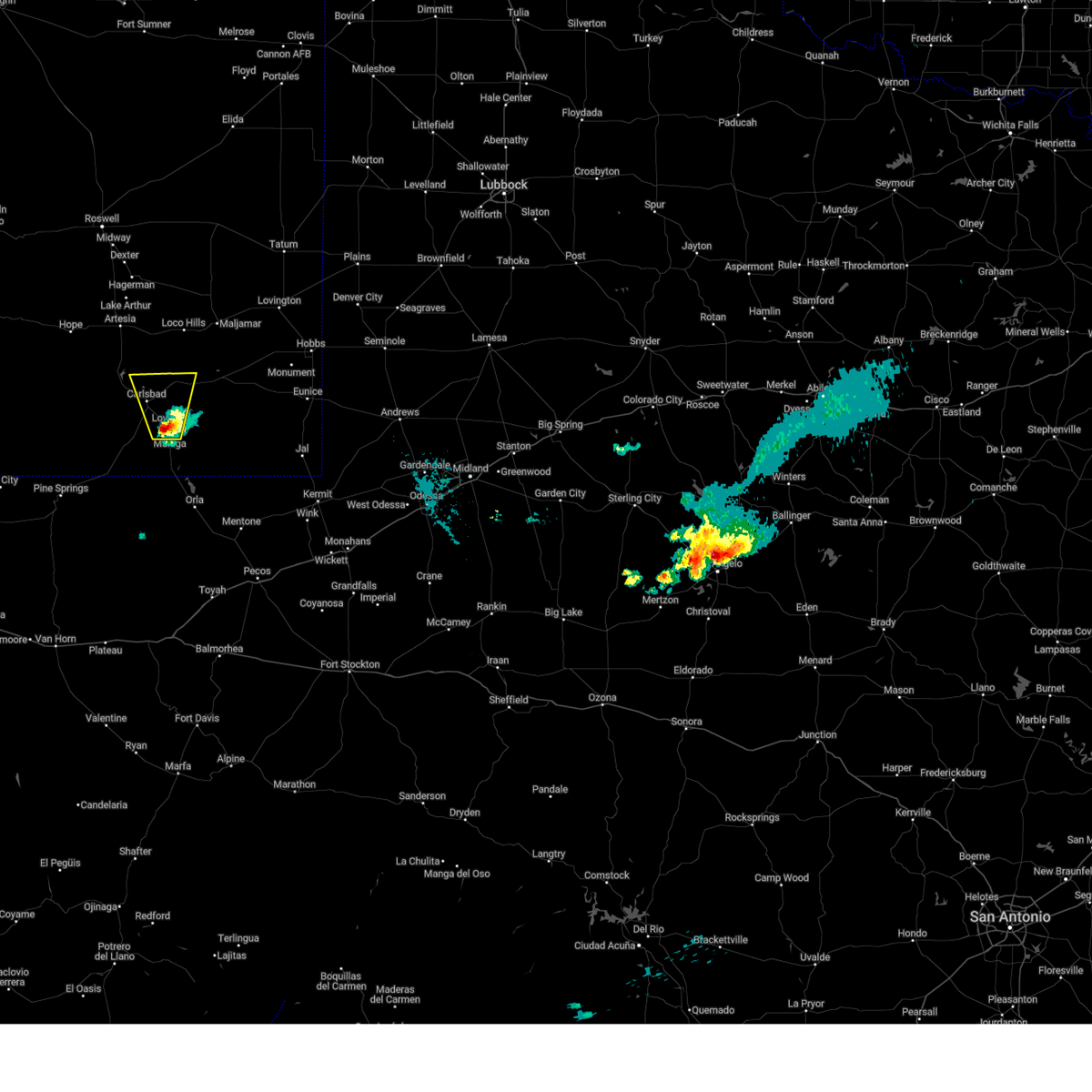
Hail Map for Carlsbad, NM
The Carlsbad, NM area has had 77 reports of on-the-ground hail by trained spotters, and has been under severe weather warnings 9 times during the past 12 months. Doppler radar has detected hail at or near Carlsbad, NM on 61 occasions, including 5 occasions during the past year.
| Name: | Carlsbad, NM |
| Where Located: | 69.9 miles SSE of Roswell, NM |
| Map: | Google Map for Carlsbad, NM |
| Population: | 26138 |
| Housing Units: | 11243 |
| More Info: | Search Google for Carlsbad, NM |
1
The Top Recent Hail Date for Carlsbad, NM is Saturday, September 21, 2024 (37th out of 61)

Hail and Wind Damage Spotted near Carlsbad, NM
| Date / Time | Report Details |
|---|---|
| 11/2/2024 1:33 PM MDT |
 the severe thunderstorm warning has been cancelled and is no longer in effect the severe thunderstorm warning has been cancelled and is no longer in effect
|
| 11/2/2024 1:13 PM MDT |
 At 112 pm mdt, a severe thunderstorm was located near loving, or 12 miles east of carlsbad, moving northeast at 25 mph (public). Hazards include golf ball size hail and 60 mph wind gusts. People and animals outdoors will be injured. expect hail damage to roofs, siding, windows, and vehicles. expect wind damage to roofs, siding, and trees. Locations impacted include, loving and otis. At 112 pm mdt, a severe thunderstorm was located near loving, or 12 miles east of carlsbad, moving northeast at 25 mph (public). Hazards include golf ball size hail and 60 mph wind gusts. People and animals outdoors will be injured. expect hail damage to roofs, siding, windows, and vehicles. expect wind damage to roofs, siding, and trees. Locations impacted include, loving and otis.
|
| 11/2/2024 12:42 PM MDT |
 Svrmaf the national weather service in midland has issued a * severe thunderstorm warning for, southeastern eddy county in southeastern new mexico, * until 145 pm mdt. * at 1242 pm mdt, a severe thunderstorm was located near loving, or 10 miles south of carlsbad, moving northeast at 25 mph (radar indicated). Hazards include 60 mph wind gusts and quarter size hail. Hail damage to vehicles is expected. Expect wind damage to roofs, siding, and trees. Svrmaf the national weather service in midland has issued a * severe thunderstorm warning for, southeastern eddy county in southeastern new mexico, * until 145 pm mdt. * at 1242 pm mdt, a severe thunderstorm was located near loving, or 10 miles south of carlsbad, moving northeast at 25 mph (radar indicated). Hazards include 60 mph wind gusts and quarter size hail. Hail damage to vehicles is expected. Expect wind damage to roofs, siding, and trees.
|
| 11/1/2024 8:14 PM MDT |
 At 814 pm mdt, a severe thunderstorm was located 7 miles north of loving, or 10 miles east of carlsbad, moving north at 20 mph (public reported golf ball size hail in loving at 751 pm mdt). Hazards include ping pong ball size hail and 60 mph wind gusts. People and animals outdoors will be injured. expect hail damage to roofs, siding, windows, and vehicles. expect wind damage to roofs, siding, and trees. This severe thunderstorm will remain over mainly rural areas of east central eddy county. At 814 pm mdt, a severe thunderstorm was located 7 miles north of loving, or 10 miles east of carlsbad, moving north at 20 mph (public reported golf ball size hail in loving at 751 pm mdt). Hazards include ping pong ball size hail and 60 mph wind gusts. People and animals outdoors will be injured. expect hail damage to roofs, siding, windows, and vehicles. expect wind damage to roofs, siding, and trees. This severe thunderstorm will remain over mainly rural areas of east central eddy county.
|
| 11/1/2024 7:59 PM MDT |
 At 759 pm mdt, a severe thunderstorm was located over loving, or 9 miles southeast of carlsbad, moving north at 15 mph (radar indicated). Hazards include two inch hail and 60 mph wind gusts. People and animals outdoors will be injured. expect hail damage to roofs, siding, windows, and vehicles. expect wind damage to roofs, siding, and trees. Locations impacted include, carlsbad, loving, avalon, carlsbad north, lake avalon, otis, and living desert state park. At 759 pm mdt, a severe thunderstorm was located over loving, or 9 miles southeast of carlsbad, moving north at 15 mph (radar indicated). Hazards include two inch hail and 60 mph wind gusts. People and animals outdoors will be injured. expect hail damage to roofs, siding, windows, and vehicles. expect wind damage to roofs, siding, and trees. Locations impacted include, carlsbad, loving, avalon, carlsbad north, lake avalon, otis, and living desert state park.
|
| 11/1/2024 7:57 PM MDT | Hen Egg sized hail reported 8.3 miles NW of Carlsbad, NM, spotter shared photo of golf ball size to two inch diameter hail in otis near derrick rd and kelly rd. |
| 11/1/2024 7:51 PM MDT |
 Svrmaf the national weather service in midland has issued a * severe thunderstorm warning for, southeastern eddy county in southeastern new mexico, * until 845 pm mdt. * at 751 pm mdt, a severe thunderstorm was located over loving, or 10 miles southeast of carlsbad, moving north at 15 mph (radar indicated). Hazards include 60 mph wind gusts and quarter size hail. Hail damage to vehicles is expected. Expect wind damage to roofs, siding, and trees. Svrmaf the national weather service in midland has issued a * severe thunderstorm warning for, southeastern eddy county in southeastern new mexico, * until 845 pm mdt. * at 751 pm mdt, a severe thunderstorm was located over loving, or 10 miles southeast of carlsbad, moving north at 15 mph (radar indicated). Hazards include 60 mph wind gusts and quarter size hail. Hail damage to vehicles is expected. Expect wind damage to roofs, siding, and trees.
|
| 9/17/2024 4:16 PM MDT | Several power lines down at the junction of us hwy 285 and helper r in eddy county NM, 6.5 miles NW of Carlsbad, NM |
| 9/17/2024 4:10 PM MDT | Asos station kcnm carlsba in eddy county NM, 5.5 miles N of Carlsbad, NM |
| 6/26/2024 7:34 PM MDT | 4 power poles snapped off from thunderstorm wind gust in eddy county NM, 14.1 miles SE of Carlsbad, NM |
| 6/12/2024 6:25 PM MDT | Asos station kcnm carlsbad. a dust storm with visibility of one quarter mile or less was observed als in eddy county NM, 5.5 miles N of Carlsbad, NM |
| 6/10/2024 3:54 PM MDT | Ping Pong Ball sized hail reported 13.8 miles N of Carlsbad, NM, spotter measured ping pong ball size hail. time estimated from radar. |
| 6/10/2024 3:50 PM MDT | Quarter sized hail reported 13.8 miles NNE of Carlsbad, NM, spotter shared photo of 1/2 inch to 1 inch hail covering the ground. time estimated from radar. |
| 6/10/2024 3:35 PM MDT |
 At 334 pm mdt, a severe thunderstorm was located 7 miles north of whites city, or 12 miles southwest of carlsbad, moving southeast at 30 mph (radar indicated). Hazards include golf ball size hail and 70 mph wind gusts. People and animals outdoors will be injured. expect hail damage to roofs, siding, windows, and vehicles. expect considerable tree damage. wind damage is also likely to mobile homes, roofs, and outbuildings. Locations impacted include, carlsbad, loving, malaga, otis, and cavern city air terminal. At 334 pm mdt, a severe thunderstorm was located 7 miles north of whites city, or 12 miles southwest of carlsbad, moving southeast at 30 mph (radar indicated). Hazards include golf ball size hail and 70 mph wind gusts. People and animals outdoors will be injured. expect hail damage to roofs, siding, windows, and vehicles. expect considerable tree damage. wind damage is also likely to mobile homes, roofs, and outbuildings. Locations impacted include, carlsbad, loving, malaga, otis, and cavern city air terminal.
|
| 6/10/2024 3:20 PM MDT |
 At 320 pm mdt, a severe thunderstorm was located 12 miles northwest of whites city, or 13 miles west of carlsbad, moving southeast at 40 mph (radar indicated). Hazards include ping pong ball size hail and 60 mph wind gusts. People and animals outdoors will be injured. expect hail damage to roofs, siding, windows, and vehicles. expect wind damage to roofs, siding, and trees. Locations impacted include, carlsbad, loving, carlsbad north, malaga, otis, cavern city air terminal, and living desert state park. At 320 pm mdt, a severe thunderstorm was located 12 miles northwest of whites city, or 13 miles west of carlsbad, moving southeast at 40 mph (radar indicated). Hazards include ping pong ball size hail and 60 mph wind gusts. People and animals outdoors will be injured. expect hail damage to roofs, siding, windows, and vehicles. expect wind damage to roofs, siding, and trees. Locations impacted include, carlsbad, loving, carlsbad north, malaga, otis, cavern city air terminal, and living desert state park.
|
| 6/10/2024 3:00 PM MDT |
 Svrmaf the national weather service in midland has issued a * severe thunderstorm warning for, central eddy county in southeastern new mexico, * until 400 pm mdt. * at 259 pm mdt, a severe thunderstorm was located 14 miles southwest of seven rivers airport, or 22 miles west of carlsbad, moving east at 30 mph (radar indicated). Hazards include ping pong ball size hail and 60 mph wind gusts. People and animals outdoors will be injured. expect hail damage to roofs, siding, windows, and vehicles. Expect wind damage to roofs, siding, and trees. Svrmaf the national weather service in midland has issued a * severe thunderstorm warning for, central eddy county in southeastern new mexico, * until 400 pm mdt. * at 259 pm mdt, a severe thunderstorm was located 14 miles southwest of seven rivers airport, or 22 miles west of carlsbad, moving east at 30 mph (radar indicated). Hazards include ping pong ball size hail and 60 mph wind gusts. People and animals outdoors will be injured. expect hail damage to roofs, siding, windows, and vehicles. Expect wind damage to roofs, siding, and trees.
|
| 10/24/2023 5:30 PM MDT | Quarter sized hail reported 9.2 miles SE of Carlsbad, NM, quarter sized hail observed along sh137 nw of carlsbad. |
| 10/2/2023 6:17 PM MDT |
 At 617 pm mdt, a severe thunderstorm was located near carlsbad, moving northeast at 25 mph (radar indicated). Hazards include 60 mph wind gusts and half dollar size hail. Hail damage to vehicles is expected. expect wind damage to roofs, siding, and trees. locations impacted include, carlsbad, loving, and otis. hail threat, radar indicated max hail size, 1. 25 in wind threat, radar indicated max wind gust, 60 mph. At 617 pm mdt, a severe thunderstorm was located near carlsbad, moving northeast at 25 mph (radar indicated). Hazards include 60 mph wind gusts and half dollar size hail. Hail damage to vehicles is expected. expect wind damage to roofs, siding, and trees. locations impacted include, carlsbad, loving, and otis. hail threat, radar indicated max hail size, 1. 25 in wind threat, radar indicated max wind gust, 60 mph.
|
| 10/2/2023 6:02 PM MDT |
 At 601 pm mdt, a severe thunderstorm was located near whites city, or 10 miles southwest of carlsbad, moving northeast at 25 mph (radar indicated. park rangers at carlsbad caverns np reported golf ball size hail earlier in this storm). Hazards include 60 mph wind gusts and half dollar size hail. Hail damage to vehicles is expected. expect wind damage to roofs, siding, and trees. locations impacted include, carlsbad, loving, whites city, carlsbad caverns national park, otis, cavern city air terminal, and living desert state park. hail threat, radar indicated max hail size, 1. 25 in wind threat, radar indicated max wind gust, 60 mph. At 601 pm mdt, a severe thunderstorm was located near whites city, or 10 miles southwest of carlsbad, moving northeast at 25 mph (radar indicated. park rangers at carlsbad caverns np reported golf ball size hail earlier in this storm). Hazards include 60 mph wind gusts and half dollar size hail. Hail damage to vehicles is expected. expect wind damage to roofs, siding, and trees. locations impacted include, carlsbad, loving, whites city, carlsbad caverns national park, otis, cavern city air terminal, and living desert state park. hail threat, radar indicated max hail size, 1. 25 in wind threat, radar indicated max wind gust, 60 mph.
|
| 10/2/2023 5:39 PM MDT | Golf ball sized hail observed in walnut canyon in carlsbad caverns national par in eddy county NM, 20.6 miles NE of Carlsbad, NM |
| 10/2/2023 5:39 PM MDT | Golf Ball sized hail reported 20.6 miles NE of Carlsbad, NM, corrects previous report. golf ball sized hail observed in walnut canyon in carlsbad caverns national park. |
| 10/2/2023 5:38 PM MDT |
 At 538 pm mdt, a severe thunderstorm was located near whites city, or 20 miles southwest of carlsbad, moving northeast at 25 mph (radar indicated). Hazards include 60 mph wind gusts and half dollar size hail. Hail damage to vehicles is expected. Expect wind damage to roofs, siding, and trees. At 538 pm mdt, a severe thunderstorm was located near whites city, or 20 miles southwest of carlsbad, moving northeast at 25 mph (radar indicated). Hazards include 60 mph wind gusts and half dollar size hail. Hail damage to vehicles is expected. Expect wind damage to roofs, siding, and trees.
|
| 10/2/2023 4:39 PM MDT |
 At 439 pm mdt, a severe thunderstorm was located 18 miles northeast of avalon, or 23 miles northeast of carlsbad, moving northeast at 35 mph (radar indicated). Hazards include 60 mph wind gusts and quarter size hail. Hail damage to vehicles is expected. expect wind damage to roofs, siding, and trees. locations impacted include, carlsbad, avalon, carlsbad north, lake avalon, lea county zip franklin memorial airport, and loco hills. hail threat, radar indicated max hail size, 1. 00 in wind threat, radar indicated max wind gust, 60 mph. At 439 pm mdt, a severe thunderstorm was located 18 miles northeast of avalon, or 23 miles northeast of carlsbad, moving northeast at 35 mph (radar indicated). Hazards include 60 mph wind gusts and quarter size hail. Hail damage to vehicles is expected. expect wind damage to roofs, siding, and trees. locations impacted include, carlsbad, avalon, carlsbad north, lake avalon, lea county zip franklin memorial airport, and loco hills. hail threat, radar indicated max hail size, 1. 00 in wind threat, radar indicated max wind gust, 60 mph.
|
| 10/2/2023 4:15 PM MDT |
 At 414 pm mdt, a severe thunderstorm was located near avalon, or 9 miles north of carlsbad, moving northeast at 35 mph (radar indicated). Hazards include 60 mph wind gusts and quarter size hail. Hail damage to vehicles is expected. Expect wind damage to roofs, siding, and trees. At 414 pm mdt, a severe thunderstorm was located near avalon, or 9 miles north of carlsbad, moving northeast at 35 mph (radar indicated). Hazards include 60 mph wind gusts and quarter size hail. Hail damage to vehicles is expected. Expect wind damage to roofs, siding, and trees.
|
| 10/2/2023 4:02 PM MDT |
 At 401 pm mdt, a severe thunderstorm was located near carlsbad, moving northeast at 30 mph (radar indicated). Hazards include ping pong ball size hail and 60 mph wind gusts. People and animals outdoors will be injured. expect hail damage to roofs, siding, windows, and vehicles. expect wind damage to roofs, siding, and trees. locations impacted include, carlsbad, brantley lake state park, avalon, carlsbad north, seven rivers airport, lake avalon, living desert state park, and lakewood. hail threat, radar indicated max hail size, 1. 50 in wind threat, radar indicated max wind gust, 60 mph. At 401 pm mdt, a severe thunderstorm was located near carlsbad, moving northeast at 30 mph (radar indicated). Hazards include ping pong ball size hail and 60 mph wind gusts. People and animals outdoors will be injured. expect hail damage to roofs, siding, windows, and vehicles. expect wind damage to roofs, siding, and trees. locations impacted include, carlsbad, brantley lake state park, avalon, carlsbad north, seven rivers airport, lake avalon, living desert state park, and lakewood. hail threat, radar indicated max hail size, 1. 50 in wind threat, radar indicated max wind gust, 60 mph.
|
| 10/2/2023 3:46 PM MDT |
 At 345 pm mdt, a severe thunderstorm was located 8 miles west of carlsbad, moving north at 10 mph (radar indicated). Hazards include 60 mph wind gusts and half dollar size hail. Hail damage to vehicles is expected. expect wind damage to roofs, siding, and trees. locations impacted include, carlsbad, brantley lake state park, avalon, carlsbad north, seven rivers airport, lake avalon, living desert state park, and lakewood. hail threat, radar indicated max hail size, 1. 25 in wind threat, radar indicated max wind gust, 60 mph. At 345 pm mdt, a severe thunderstorm was located 8 miles west of carlsbad, moving north at 10 mph (radar indicated). Hazards include 60 mph wind gusts and half dollar size hail. Hail damage to vehicles is expected. expect wind damage to roofs, siding, and trees. locations impacted include, carlsbad, brantley lake state park, avalon, carlsbad north, seven rivers airport, lake avalon, living desert state park, and lakewood. hail threat, radar indicated max hail size, 1. 25 in wind threat, radar indicated max wind gust, 60 mph.
|
| 10/2/2023 3:41 PM MDT | Wind gusts at or above 60 mp in eddy county NM, 4.2 miles SE of Carlsbad, NM |
| 10/2/2023 3:26 PM MDT |
 At 326 pm mdt, a severe thunderstorm was located 9 miles west of carlsbad, moving north at 10 mph (radar indicated). Hazards include 60 mph wind gusts and half dollar size hail. Hail damage to vehicles is expected. Expect wind damage to roofs, siding, and trees. At 326 pm mdt, a severe thunderstorm was located 9 miles west of carlsbad, moving north at 10 mph (radar indicated). Hazards include 60 mph wind gusts and half dollar size hail. Hail damage to vehicles is expected. Expect wind damage to roofs, siding, and trees.
|
| 10/2/2023 3:06 PM MDT |
 At 306 pm mdt, a severe thunderstorm was located over carlsbad north, or near carlsbad, moving northeast at 30 mph (radar indicated). Hazards include 70 mph wind gusts and half dollar size hail. Hail damage to vehicles is expected. expect considerable tree damage. wind damage is also likely to mobile homes, roofs, and outbuildings. locations impacted include, carlsbad, avalon, carlsbad north, lake avalon, otis, cavern city air terminal, and living desert state park. thunderstorm damage threat, considerable hail threat, radar indicated max hail size, 1. 25 in wind threat, radar indicated max wind gust, 70 mph. At 306 pm mdt, a severe thunderstorm was located over carlsbad north, or near carlsbad, moving northeast at 30 mph (radar indicated). Hazards include 70 mph wind gusts and half dollar size hail. Hail damage to vehicles is expected. expect considerable tree damage. wind damage is also likely to mobile homes, roofs, and outbuildings. locations impacted include, carlsbad, avalon, carlsbad north, lake avalon, otis, cavern city air terminal, and living desert state park. thunderstorm damage threat, considerable hail threat, radar indicated max hail size, 1. 25 in wind threat, radar indicated max wind gust, 70 mph.
|
| 10/2/2023 2:59 PM MDT |
 At 259 pm mdt, a severe thunderstorm was located over carlsbad north, or over carlsbad, moving northeast at 30 mph (radar indicated). Hazards include 70 mph wind gusts and ping pong ball size hail. People and animals outdoors will be injured. expect hail damage to roofs, siding, windows, and vehicles. expect considerable tree damage. wind damage is also likely to mobile homes, roofs, and outbuildings. Locations impacted include, carlsbad, brantley lake state park, avalon, carlsbad north, lake avalon, otis, cavern city air terminal, and living desert state park. At 259 pm mdt, a severe thunderstorm was located over carlsbad north, or over carlsbad, moving northeast at 30 mph (radar indicated). Hazards include 70 mph wind gusts and ping pong ball size hail. People and animals outdoors will be injured. expect hail damage to roofs, siding, windows, and vehicles. expect considerable tree damage. wind damage is also likely to mobile homes, roofs, and outbuildings. Locations impacted include, carlsbad, brantley lake state park, avalon, carlsbad north, lake avalon, otis, cavern city air terminal, and living desert state park.
|
| 10/2/2023 2:52 PM MDT |
 At 251 pm mdt, a severe thunderstorm was located over carlsbad, moving northeast at 30 mph (radar indicated). Hazards include two inch hail and 70 mph wind gusts. People and animals outdoors will be injured. expect hail damage to roofs, siding, windows, and vehicles. expect considerable tree damage. wind damage is also likely to mobile homes, roofs, and outbuildings. Locations impacted include, carlsbad, brantley lake state park, avalon, carlsbad north, lake avalon, otis, cavern city air terminal, and living desert state park. At 251 pm mdt, a severe thunderstorm was located over carlsbad, moving northeast at 30 mph (radar indicated). Hazards include two inch hail and 70 mph wind gusts. People and animals outdoors will be injured. expect hail damage to roofs, siding, windows, and vehicles. expect considerable tree damage. wind damage is also likely to mobile homes, roofs, and outbuildings. Locations impacted include, carlsbad, brantley lake state park, avalon, carlsbad north, lake avalon, otis, cavern city air terminal, and living desert state park.
|
| 10/2/2023 2:43 PM MDT |
 At 242 pm mdt, a severe thunderstorm was located near carlsbad, moving northeast at 30 mph (radar indicated). Hazards include golf ball size hail and 60 mph wind gusts. People and animals outdoors will be injured. expect hail damage to roofs, siding, windows, and vehicles. Expect wind damage to roofs, siding, and trees. At 242 pm mdt, a severe thunderstorm was located near carlsbad, moving northeast at 30 mph (radar indicated). Hazards include golf ball size hail and 60 mph wind gusts. People and animals outdoors will be injured. expect hail damage to roofs, siding, windows, and vehicles. Expect wind damage to roofs, siding, and trees.
|
| 10/2/2023 1:48 PM MDT |
 At 148 pm mdt, a severe thunderstorm was located over brantley lake state park, or 12 miles northwest of carlsbad, moving northeast at 15 mph (trained weather spotter reported quarter sized hail along hwy 285). Hazards include 60 mph wind gusts and half dollar size hail. Hail damage to vehicles is expected. expect wind damage to roofs, siding, and trees. locations impacted include, carlsbad, brantley lake state park, avalon, seven rivers airport, carlsbad north, lake avalon, living desert state park, dayton, and lakewood. hail threat, radar indicated max hail size, 1. 25 in wind threat, radar indicated max wind gust, 60 mph. At 148 pm mdt, a severe thunderstorm was located over brantley lake state park, or 12 miles northwest of carlsbad, moving northeast at 15 mph (trained weather spotter reported quarter sized hail along hwy 285). Hazards include 60 mph wind gusts and half dollar size hail. Hail damage to vehicles is expected. expect wind damage to roofs, siding, and trees. locations impacted include, carlsbad, brantley lake state park, avalon, seven rivers airport, carlsbad north, lake avalon, living desert state park, dayton, and lakewood. hail threat, radar indicated max hail size, 1. 25 in wind threat, radar indicated max wind gust, 60 mph.
|
| 10/2/2023 1:46 PM MDT | Quarter sized hail reported 10.1 miles SE of Carlsbad, NM, quarter sized hail and wind gusts over 60 mph along us285 northwest of carlsbad. |
| 10/2/2023 1:43 PM MDT |
 At 143 pm mdt, a severe thunderstorm was located over brantley lake state park, or 12 miles northwest of carlsbad, moving northeast at 15 mph (radar indicated). Hazards include ping pong ball size hail and 60 mph wind gusts. People and animals outdoors will be injured. expect hail damage to roofs, siding, windows, and vehicles. Expect wind damage to roofs, siding, and trees. At 143 pm mdt, a severe thunderstorm was located over brantley lake state park, or 12 miles northwest of carlsbad, moving northeast at 15 mph (radar indicated). Hazards include ping pong ball size hail and 60 mph wind gusts. People and animals outdoors will be injured. expect hail damage to roofs, siding, windows, and vehicles. Expect wind damage to roofs, siding, and trees.
|
| 10/2/2023 1:37 PM MDT | Tennis Ball sized hail reported 12 miles ESE of Carlsbad, NM, relayed report from nmdot employee... tennis ball size hail on us285. time estimated from radar. |
| 10/2/2023 1:36 PM MDT | Golf Ball sized hail reported 11 miles SE of Carlsbad, NM, golf ball sized hail along us285. time estimated from radar. |
| 10/2/2023 1:21 PM MDT |
 At 121 pm mdt, a severe thunderstorm was located near brantley lake state park, or 13 miles northwest of carlsbad, moving northeast at 15 mph. this is a destructive storm for northwestern eddy count north of carlsbad (radar indicated). Hazards include baseball size hail and 70 mph wind gusts. People and animals outdoors will be severely injured. expect shattered windows, extensive damage to roofs, siding, and vehicles. locations impacted include, avalon, brantley lake state park, seven rivers airport, lake avalon, and living desert state park. thunderstorm damage threat, destructive hail threat, radar indicated max hail size, 2. 75 in wind threat, radar indicated max wind gust, 70 mph. At 121 pm mdt, a severe thunderstorm was located near brantley lake state park, or 13 miles northwest of carlsbad, moving northeast at 15 mph. this is a destructive storm for northwestern eddy count north of carlsbad (radar indicated). Hazards include baseball size hail and 70 mph wind gusts. People and animals outdoors will be severely injured. expect shattered windows, extensive damage to roofs, siding, and vehicles. locations impacted include, avalon, brantley lake state park, seven rivers airport, lake avalon, and living desert state park. thunderstorm damage threat, destructive hail threat, radar indicated max hail size, 2. 75 in wind threat, radar indicated max wind gust, 70 mph.
|
| 10/2/2023 1:13 PM MDT |
 At 113 pm mdt, a severe thunderstorm was located 8 miles southwest of brantley lake state park, or 14 miles west of carlsbad, moving northeast at 15 mph (radar indicated). Hazards include two inch hail and 70 mph wind gusts. People and animals outdoors will be injured. expect hail damage to roofs, siding, windows, and vehicles. expect considerable tree damage. wind damage is also likely to mobile homes, roofs, and outbuildings. locations impacted include, carlsbad, avalon, brantley lake state park, seven rivers airport, lake avalon, and living desert state park. thunderstorm damage threat, considerable hail threat, radar indicated max hail size, 2. 00 in wind threat, radar indicated max wind gust, 70 mph. At 113 pm mdt, a severe thunderstorm was located 8 miles southwest of brantley lake state park, or 14 miles west of carlsbad, moving northeast at 15 mph (radar indicated). Hazards include two inch hail and 70 mph wind gusts. People and animals outdoors will be injured. expect hail damage to roofs, siding, windows, and vehicles. expect considerable tree damage. wind damage is also likely to mobile homes, roofs, and outbuildings. locations impacted include, carlsbad, avalon, brantley lake state park, seven rivers airport, lake avalon, and living desert state park. thunderstorm damage threat, considerable hail threat, radar indicated max hail size, 2. 00 in wind threat, radar indicated max wind gust, 70 mph.
|
| 10/2/2023 1:11 PM MDT | Golf Ball sized hail reported 9.2 miles SE of Carlsbad, NM, golfball size hail (some bigger possible) along state highway 137 near rocky arroyo crossing. wind driven hail broke windshields... and fences were blown down. time est |
| 10/2/2023 1:02 PM MDT |
 At 102 pm mdt, a severe thunderstorm was located 12 miles southwest of brantley lake state park, or 17 miles west of carlsbad, moving northeast at 15 mph (radar indicated). Hazards include 70 mph wind gusts and ping pong ball size hail. People and animals outdoors will be injured. expect hail damage to roofs, siding, windows, and vehicles. expect considerable tree damage. Wind damage is also likely to mobile homes, roofs, and outbuildings. At 102 pm mdt, a severe thunderstorm was located 12 miles southwest of brantley lake state park, or 17 miles west of carlsbad, moving northeast at 15 mph (radar indicated). Hazards include 70 mph wind gusts and ping pong ball size hail. People and animals outdoors will be injured. expect hail damage to roofs, siding, windows, and vehicles. expect considerable tree damage. Wind damage is also likely to mobile homes, roofs, and outbuildings.
|
| 9/11/2023 7:11 PM MDT |
 At 810 pm cdt/710 pm mdt/, severe thunderstorms were located along a line extending from 6 miles northwest of monument to 10 miles northeast of loving to 8 miles north of whites city, moving east at 50 mph (asos measured 66 mph wind gusts in carlsbad). Hazards include 70 mph wind gusts and penny size hail, as well as blowing dust reducing visibility. Expect considerable tree damage. Damage is likely to mobile homes, roofs, and outbuildings. At 810 pm cdt/710 pm mdt/, severe thunderstorms were located along a line extending from 6 miles northwest of monument to 10 miles northeast of loving to 8 miles north of whites city, moving east at 50 mph (asos measured 66 mph wind gusts in carlsbad). Hazards include 70 mph wind gusts and penny size hail, as well as blowing dust reducing visibility. Expect considerable tree damage. Damage is likely to mobile homes, roofs, and outbuildings.
|
| 9/11/2023 7:09 PM MDT | Asos station kcnm carlsba in eddy county NM, 5.5 miles N of Carlsbad, NM |
| 9/11/2023 7:02 PM MDT | Social media pictures show store siding remove in eddy county NM, 1.4 miles NNE of Carlsbad, NM |
| 8/21/2023 7:10 PM MDT | Observed by personal weather statio in eddy county NM, 2.1 miles SW of Carlsbad, NM |
| 6/7/2023 6:03 PM MDT |
 At 603 pm mdt, a severe thunderstorm was located 8 miles east of carlsbad north, or 8 miles east of carlsbad, moving east at 15 mph (radar indicated). Hazards include 60 mph wind gusts and quarter size hail. Hail damage to vehicles is expected. expect wind damage to roofs, siding, and trees. locations impacted include, loving, malaga and otis. hail threat, radar indicated max hail size, 1. 00 in wind threat, radar indicated max wind gust, 60 mph. At 603 pm mdt, a severe thunderstorm was located 8 miles east of carlsbad north, or 8 miles east of carlsbad, moving east at 15 mph (radar indicated). Hazards include 60 mph wind gusts and quarter size hail. Hail damage to vehicles is expected. expect wind damage to roofs, siding, and trees. locations impacted include, loving, malaga and otis. hail threat, radar indicated max hail size, 1. 00 in wind threat, radar indicated max wind gust, 60 mph.
|
| 6/7/2023 5:39 PM MDT |
 At 539 pm mdt, a severe thunderstorm was located over carlsbad north, or over carlsbad, moving east at 10 mph (radar indicated). Hazards include 60 mph wind gusts and quarter size hail. Hail damage to vehicles is expected. Expect wind damage to roofs, siding, and trees. At 539 pm mdt, a severe thunderstorm was located over carlsbad north, or over carlsbad, moving east at 10 mph (radar indicated). Hazards include 60 mph wind gusts and quarter size hail. Hail damage to vehicles is expected. Expect wind damage to roofs, siding, and trees.
|
| 5/26/2023 9:09 PM MDT |
 At 909 pm mdt, a severe thunderstorm was located near whites city, or 15 miles south of carlsbad, moving northeast at 35 mph (radar indicated). Hazards include 60 mph wind gusts and quarter size hail. Hail damage to vehicles is expected. expect wind damage to roofs, siding, and trees. locations impacted include, carlsbad, loving, malaga, whites city, carlsbad north, carlsbad caverns national park, otis and cavern city air terminal. hail threat, radar indicated max hail size, 1. 00 in wind threat, radar indicated max wind gust, 60 mph. At 909 pm mdt, a severe thunderstorm was located near whites city, or 15 miles south of carlsbad, moving northeast at 35 mph (radar indicated). Hazards include 60 mph wind gusts and quarter size hail. Hail damage to vehicles is expected. expect wind damage to roofs, siding, and trees. locations impacted include, carlsbad, loving, malaga, whites city, carlsbad north, carlsbad caverns national park, otis and cavern city air terminal. hail threat, radar indicated max hail size, 1. 00 in wind threat, radar indicated max wind gust, 60 mph.
|
| 5/26/2023 8:55 PM MDT |
 At 954 pm cdt/854 pm mdt/, a severe thunderstorm was located near whites city, or 22 miles south of carlsbad, moving northeast at 40 mph (radar indicated). Hazards include ping pong ball size hail and 60 mph wind gusts. People and animals outdoors will be injured. expect hail damage to roofs, siding, windows, and vehicles. Expect wind damage to roofs, siding, and trees. At 954 pm cdt/854 pm mdt/, a severe thunderstorm was located near whites city, or 22 miles south of carlsbad, moving northeast at 40 mph (radar indicated). Hazards include ping pong ball size hail and 60 mph wind gusts. People and animals outdoors will be injured. expect hail damage to roofs, siding, windows, and vehicles. Expect wind damage to roofs, siding, and trees.
|
| 5/22/2023 3:56 PM MDT |
 At 356 pm mdt, a severe thunderstorm was located near carlsbad, moving southeast at 10 mph (radar indicated). Hazards include 60 mph wind gusts and quarter size hail. Hail damage to vehicles is expected. Expect wind damage to roofs, siding, and trees. At 356 pm mdt, a severe thunderstorm was located near carlsbad, moving southeast at 10 mph (radar indicated). Hazards include 60 mph wind gusts and quarter size hail. Hail damage to vehicles is expected. Expect wind damage to roofs, siding, and trees.
|
| 5/21/2023 3:15 PM MDT | Storm damage reported in eddy county NM, 10.9 miles NE of Carlsbad, NM |
| 5/3/2023 6:20 PM MDT |
 At 619 pm mdt, severe thunderstorms were located along a line extending from 15 miles northeast of loving to near brantley lake state park, moving northeast at 25 mph (trained weather spotters. at 709 pm mdt a trained spotter measured a 66 mph wind gust 6 miles west of avalon, nm). Hazards include 60 mph wind gusts and quarter size hail. Hail damage to vehicles is expected. expect wind damage to roofs, siding, and trees. locations impacted include, carlsbad, artesia, avalon, seven rivers airport, brantley lake state park, carlsbad north, artesia municipal airport, living desert state park, dayton, lakewood, halfway, atoka and lake avalon. hail threat, radar indicated max hail size, 1. 00 in wind threat, observed max wind gust, 60 mph. At 619 pm mdt, severe thunderstorms were located along a line extending from 15 miles northeast of loving to near brantley lake state park, moving northeast at 25 mph (trained weather spotters. at 709 pm mdt a trained spotter measured a 66 mph wind gust 6 miles west of avalon, nm). Hazards include 60 mph wind gusts and quarter size hail. Hail damage to vehicles is expected. expect wind damage to roofs, siding, and trees. locations impacted include, carlsbad, artesia, avalon, seven rivers airport, brantley lake state park, carlsbad north, artesia municipal airport, living desert state park, dayton, lakewood, halfway, atoka and lake avalon. hail threat, radar indicated max hail size, 1. 00 in wind threat, observed max wind gust, 60 mph.
|
| 5/3/2023 6:09 PM MDT | Spotter reported sustained winds of 53 mph with gusts to 66 mph from vehicle anemomete in eddy county NM, 8.7 miles SE of Carlsbad, NM |
| 5/3/2023 6:03 PM MDT |
 At 603 pm mdt, severe thunderstorms were located along a line extending from near loving to near brantley lake state park, moving northeast at 25 mph (radar indicated). Hazards include 60 mph wind gusts and quarter size hail. Hail damage to vehicles is expected. Expect wind damage to roofs, siding, and trees. At 603 pm mdt, severe thunderstorms were located along a line extending from near loving to near brantley lake state park, moving northeast at 25 mph (radar indicated). Hazards include 60 mph wind gusts and quarter size hail. Hail damage to vehicles is expected. Expect wind damage to roofs, siding, and trees.
|
| 5/3/2023 5:56 PM MDT | Asos station kcnm carlsba in eddy county NM, 5.5 miles N of Carlsbad, NM |
| 7/24/2022 6:56 PM MDT | At the carlsbad aso in eddy county NM, 5 miles NNE of Carlsbad, NM |
| 7/4/2022 2:13 PM MDT | Numerous reports of broken tree limbs in tow in eddy county NM, 0.7 miles NNE of Carlsbad, NM |
| 6/26/2022 4:14 PM MDT | Multiple tree branches down... some as large as six inches in diamete in eddy county NM, 1.5 miles SSW of Carlsbad, NM |
| 6/3/2022 6:38 PM MDT | Hen Egg sized hail reported 10.8 miles NNE of Carlsbad, NM, report from mping: hen egg (2.00 in.). |
| 6/3/2022 6:26 PM MDT |
 At 726 pm cdt/626 pm mdt/, a severe thunderstorm was located 10 miles south of whites city, or 26 miles south of carlsbad, moving east at 10 mph (radar indicated). Hazards include 60 mph wind gusts and half dollar size hail. Hail damage to vehicles is expected. Expect wind damage to roofs, siding, and trees. At 726 pm cdt/626 pm mdt/, a severe thunderstorm was located 10 miles south of whites city, or 26 miles south of carlsbad, moving east at 10 mph (radar indicated). Hazards include 60 mph wind gusts and half dollar size hail. Hail damage to vehicles is expected. Expect wind damage to roofs, siding, and trees.
|
| 6/3/2022 6:06 PM MDT |
 At 606 pm mdt, a severe thunderstorm was located 10 miles southwest of carlsbad, moving southeast at 15 mph (radar indicated). Hazards include ping pong ball size hail and 60 mph wind gusts. People and animals outdoors will be injured. expect hail damage to roofs, siding, windows, and vehicles. expect wind damage to roofs, siding, and trees. locations impacted include, carlsbad, loving, whites city, carlsbad caverns national park, otis, cavern city air terminal and living desert state park. hail threat, radar indicated max hail size, 1. 50 in wind threat, radar indicated max wind gust, 60 mph. At 606 pm mdt, a severe thunderstorm was located 10 miles southwest of carlsbad, moving southeast at 15 mph (radar indicated). Hazards include ping pong ball size hail and 60 mph wind gusts. People and animals outdoors will be injured. expect hail damage to roofs, siding, windows, and vehicles. expect wind damage to roofs, siding, and trees. locations impacted include, carlsbad, loving, whites city, carlsbad caverns national park, otis, cavern city air terminal and living desert state park. hail threat, radar indicated max hail size, 1. 50 in wind threat, radar indicated max wind gust, 60 mph.
|
| 6/3/2022 5:56 PM MDT |
 At 556 pm mdt, a severe thunderstorm was located 12 miles west of carlsbad, moving southeast at 15 mph (radar indicated). Hazards include ping pong ball size hail and 60 mph wind gusts. People and animals outdoors will be injured. expect hail damage to roofs, siding, windows, and vehicles. expect wind damage to roofs, siding, and trees. locations impacted include, carlsbad, loving, whites city, carlsbad caverns national park, otis, cavern city air terminal and living desert state park. hail threat, radar indicated max hail size, 1. 50 in wind threat, radar indicated max wind gust, 60 mph. At 556 pm mdt, a severe thunderstorm was located 12 miles west of carlsbad, moving southeast at 15 mph (radar indicated). Hazards include ping pong ball size hail and 60 mph wind gusts. People and animals outdoors will be injured. expect hail damage to roofs, siding, windows, and vehicles. expect wind damage to roofs, siding, and trees. locations impacted include, carlsbad, loving, whites city, carlsbad caverns national park, otis, cavern city air terminal and living desert state park. hail threat, radar indicated max hail size, 1. 50 in wind threat, radar indicated max wind gust, 60 mph.
|
| 6/3/2022 5:42 PM MDT |
 At 542 pm mdt, a severe thunderstorm was located 11 miles southwest of brantley lake state park, or 14 miles west of carlsbad, moving southeast at 15 mph (radar indicated). Hazards include 60 mph wind gusts and half dollar size hail. Hail damage to vehicles is expected. Expect wind damage to roofs, siding, and trees. At 542 pm mdt, a severe thunderstorm was located 11 miles southwest of brantley lake state park, or 14 miles west of carlsbad, moving southeast at 15 mph (radar indicated). Hazards include 60 mph wind gusts and half dollar size hail. Hail damage to vehicles is expected. Expect wind damage to roofs, siding, and trees.
|
| 6/3/2022 5:16 PM MDT |
 At 515 pm mdt, a severe thunderstorm was located 7 miles southwest of seven rivers airport, or 17 miles northwest of carlsbad, moving southeast at 20 mph (radar indicated). Hazards include 60 mph wind gusts and half dollar size hail. Hail damage to vehicles is expected. expect wind damage to roofs, siding, and trees. locations impacted include, avalon, brantley lake state park, seven rivers airport, lake avalon and living desert state park. hail threat, radar indicated max hail size, 1. 25 in wind threat, radar indicated max wind gust, 60 mph. At 515 pm mdt, a severe thunderstorm was located 7 miles southwest of seven rivers airport, or 17 miles northwest of carlsbad, moving southeast at 20 mph (radar indicated). Hazards include 60 mph wind gusts and half dollar size hail. Hail damage to vehicles is expected. expect wind damage to roofs, siding, and trees. locations impacted include, avalon, brantley lake state park, seven rivers airport, lake avalon and living desert state park. hail threat, radar indicated max hail size, 1. 25 in wind threat, radar indicated max wind gust, 60 mph.
|
| 6/3/2022 5:00 PM MDT |
 At 500 pm mdt, a severe thunderstorm was located 11 miles west of seven rivers airport, or 18 miles south of hope, moving southeast at 15 mph (radar indicated). Hazards include 60 mph wind gusts and quarter size hail. Hail damage to vehicles is expected. Expect wind damage to roofs, siding, and trees. At 500 pm mdt, a severe thunderstorm was located 11 miles west of seven rivers airport, or 18 miles south of hope, moving southeast at 15 mph (radar indicated). Hazards include 60 mph wind gusts and quarter size hail. Hail damage to vehicles is expected. Expect wind damage to roofs, siding, and trees.
|
| 7/5/2021 3:31 AM MDT |
 At 331 am mdt, severe thunderstorms were located along a line extending from near nadine to 7 miles west of eunice airport to 14 miles east of loving to near brantley lake state park to 11 miles southeast of hope, moving south at 30 mph (radar indicated). Hazards include 60 mph wind gusts and nickel size hail. Expect damage to roofs, siding, and trees. Locations impacted include, hobbs, carlsbad, artesia, lovington, eunice, loving, monument, humble city, avalon, maljamar, eunice airport, seven rivers airport, nadine, brantley lake state park, carlsbad north, malaga, loco hills, otis, dayton and halfway. At 331 am mdt, severe thunderstorms were located along a line extending from near nadine to 7 miles west of eunice airport to 14 miles east of loving to near brantley lake state park to 11 miles southeast of hope, moving south at 30 mph (radar indicated). Hazards include 60 mph wind gusts and nickel size hail. Expect damage to roofs, siding, and trees. Locations impacted include, hobbs, carlsbad, artesia, lovington, eunice, loving, monument, humble city, avalon, maljamar, eunice airport, seven rivers airport, nadine, brantley lake state park, carlsbad north, malaga, loco hills, otis, dayton and halfway.
|
| 7/5/2021 3:00 AM MDT |
 At 300 am mdt, severe thunderstorms were located along a line extending from 7 miles northeast of hobbs to 6 miles west of monument to 22 miles east of carlsbad north to 7 miles south of artesia to 10 miles northeast of hope, moving south at 35 mph (radar indicated). Hazards include 60 mph wind gusts and nickel size hail. expect damage to roofs, siding, and trees At 300 am mdt, severe thunderstorms were located along a line extending from 7 miles northeast of hobbs to 6 miles west of monument to 22 miles east of carlsbad north to 7 miles south of artesia to 10 miles northeast of hope, moving south at 35 mph (radar indicated). Hazards include 60 mph wind gusts and nickel size hail. expect damage to roofs, siding, and trees
|
| 5/28/2021 9:40 PM MDT |
 At 1039 pm cdt/939 pm mdt/, a severe thunderstorm was located over loving, or 9 miles southeast of carlsbad, moving southeast at 25 mph (radar indicated). Hazards include 60 mph wind gusts and half dollar size hail. Hail damage to vehicles is expected. Expect wind damage to roofs, siding, and trees. At 1039 pm cdt/939 pm mdt/, a severe thunderstorm was located over loving, or 9 miles southeast of carlsbad, moving southeast at 25 mph (radar indicated). Hazards include 60 mph wind gusts and half dollar size hail. Hail damage to vehicles is expected. Expect wind damage to roofs, siding, and trees.
|
| 5/28/2021 9:29 PM MDT |
 At 929 pm mdt, severe thunderstorms were located along a line extending from 25 miles west of eunice airport to 16 miles northeast of malaga to near loving to near carlsbad to 12 miles southwest of brantley lake state park, moving southeast at 25 mph (radar indicated). Hazards include ping pong ball size hail and 60 mph wind gusts. People and animals outdoors will be injured. expect hail damage to roofs, siding, windows, and vehicles. expect wind damage to roofs, siding, and trees. Locations impacted include, carlsbad, loving, avalon, malaga, carlsbad north, whites city, carlsbad caverns national park, lincoln national forest, otis, cavern city air terminal, living desert state park, halfway and lake avalon. At 929 pm mdt, severe thunderstorms were located along a line extending from 25 miles west of eunice airport to 16 miles northeast of malaga to near loving to near carlsbad to 12 miles southwest of brantley lake state park, moving southeast at 25 mph (radar indicated). Hazards include ping pong ball size hail and 60 mph wind gusts. People and animals outdoors will be injured. expect hail damage to roofs, siding, windows, and vehicles. expect wind damage to roofs, siding, and trees. Locations impacted include, carlsbad, loving, avalon, malaga, carlsbad north, whites city, carlsbad caverns national park, lincoln national forest, otis, cavern city air terminal, living desert state park, halfway and lake avalon.
|
| 5/28/2021 9:14 PM MDT | Hen Egg sized hail reported 9.6 miles SE of Carlsbad, NM, spotter reports quarter size hail falling with hen egg size hail on the highway. |
| 5/28/2021 9:13 PM MDT | Quarter sized hail reported 0.7 miles NNE of Carlsbad, NM, social media photo of quarter size hail in carlsbad. |
| 5/28/2021 8:54 PM MDT |
 At 853 pm mdt, severe thunderstorms were located along a line extending from 16 miles southeast of maljamar to near avalon to 14 miles west of seven rivers airport, moving south at 45 mph (radar indicated). Hazards include ping pong ball size hail and 60 mph wind gusts. People and animals outdoors will be injured. expect hail damage to roofs, siding, windows, and vehicles. expect wind damage to roofs, siding, and trees. Locations impacted include, carlsbad, loving, avalon, seven rivers airport, malaga, brantley lake state park, carlsbad north, whites city, carlsbad caverns national park, lincoln national forest, otis, cavern city air terminal, living desert state park, lakewood, halfway and lake avalon. At 853 pm mdt, severe thunderstorms were located along a line extending from 16 miles southeast of maljamar to near avalon to 14 miles west of seven rivers airport, moving south at 45 mph (radar indicated). Hazards include ping pong ball size hail and 60 mph wind gusts. People and animals outdoors will be injured. expect hail damage to roofs, siding, windows, and vehicles. expect wind damage to roofs, siding, and trees. Locations impacted include, carlsbad, loving, avalon, seven rivers airport, malaga, brantley lake state park, carlsbad north, whites city, carlsbad caverns national park, lincoln national forest, otis, cavern city air terminal, living desert state park, lakewood, halfway and lake avalon.
|
| 5/28/2021 8:38 PM MDT |
 At 838 pm mdt, a severe thunderstorm was located 8 miles north of avalon, or 14 miles north of carlsbad, moving southeast at 35 mph (radar indicated). Hazards include ping pong ball size hail and 60 mph wind gusts. People and animals outdoors will be injured. expect hail damage to roofs, siding, windows, and vehicles. Expect wind damage to roofs, siding, and trees. At 838 pm mdt, a severe thunderstorm was located 8 miles north of avalon, or 14 miles north of carlsbad, moving southeast at 35 mph (radar indicated). Hazards include ping pong ball size hail and 60 mph wind gusts. People and animals outdoors will be injured. expect hail damage to roofs, siding, windows, and vehicles. Expect wind damage to roofs, siding, and trees.
|
| 5/23/2021 7:46 PM MDT |
 At 745 pm mdt, a severe thunderstorm was located near carlsbad caverns national park, or 23 miles southwest of carlsbad, moving northeast at 10 mph (radar indicated). Hazards include 60 mph wind gusts and half dollar size hail. Hail damage to vehicles is expected. expect wind damage to roofs, siding, and trees. Locations impacted include, carlsbad, carlsbad caverns national park and cavern city air terminal. At 745 pm mdt, a severe thunderstorm was located near carlsbad caverns national park, or 23 miles southwest of carlsbad, moving northeast at 10 mph (radar indicated). Hazards include 60 mph wind gusts and half dollar size hail. Hail damage to vehicles is expected. expect wind damage to roofs, siding, and trees. Locations impacted include, carlsbad, carlsbad caverns national park and cavern city air terminal.
|
| 5/23/2021 7:18 PM MDT |
 At 717 pm mdt, a severe thunderstorm was located near carlsbad caverns national park, or 23 miles southwest of carlsbad, moving north at 25 mph (radar indicated). Hazards include 60 mph wind gusts and half dollar size hail. Hail damage to vehicles is expected. Expect wind damage to roofs, siding, and trees. At 717 pm mdt, a severe thunderstorm was located near carlsbad caverns national park, or 23 miles southwest of carlsbad, moving north at 25 mph (radar indicated). Hazards include 60 mph wind gusts and half dollar size hail. Hail damage to vehicles is expected. Expect wind damage to roofs, siding, and trees.
|
| 5/14/2021 7:46 PM MDT |
 At 746 pm mdt, a severe thunderstorm was located 7 miles south of carlsbad, moving east at 10 mph (radar indicated). Hazards include 60 mph wind gusts and quarter size hail. Hail damage to vehicles is expected. expect wind damage to roofs, siding, and trees. Locations impacted include, carlsbad, loving, carlsbad north, carlsbad caverns national park, otis, cavern city air terminal and living desert state park. At 746 pm mdt, a severe thunderstorm was located 7 miles south of carlsbad, moving east at 10 mph (radar indicated). Hazards include 60 mph wind gusts and quarter size hail. Hail damage to vehicles is expected. expect wind damage to roofs, siding, and trees. Locations impacted include, carlsbad, loving, carlsbad north, carlsbad caverns national park, otis, cavern city air terminal and living desert state park.
|
| 5/14/2021 7:33 PM MDT |
 At 732 pm mdt, a severe thunderstorm was located 8 miles southwest of carlsbad, moving east at 15 mph (radar indicated). Hazards include two inch hail and 70 mph wind gusts. People and animals outdoors will be injured. expect hail damage to roofs, siding, windows, and vehicles. expect considerable tree damage. wind damage is also likely to mobile homes, roofs, and outbuildings. Locations impacted include, carlsbad, loving, carlsbad north, carlsbad caverns national park, otis, cavern city air terminal and living desert state park. At 732 pm mdt, a severe thunderstorm was located 8 miles southwest of carlsbad, moving east at 15 mph (radar indicated). Hazards include two inch hail and 70 mph wind gusts. People and animals outdoors will be injured. expect hail damage to roofs, siding, windows, and vehicles. expect considerable tree damage. wind damage is also likely to mobile homes, roofs, and outbuildings. Locations impacted include, carlsbad, loving, carlsbad north, carlsbad caverns national park, otis, cavern city air terminal and living desert state park.
|
| 5/14/2021 7:11 PM MDT |
 At 711 pm mdt, a severe thunderstorm was located 9 miles northwest of whites city, or 13 miles southwest of carlsbad, moving east at 10 mph (radar indicated). Hazards include two inch hail and 70 mph wind gusts. People and animals outdoors will be injured. expect hail damage to roofs, siding, windows, and vehicles. expect considerable tree damage. Wind damage is also likely to mobile homes, roofs, and outbuildings. At 711 pm mdt, a severe thunderstorm was located 9 miles northwest of whites city, or 13 miles southwest of carlsbad, moving east at 10 mph (radar indicated). Hazards include two inch hail and 70 mph wind gusts. People and animals outdoors will be injured. expect hail damage to roofs, siding, windows, and vehicles. expect considerable tree damage. Wind damage is also likely to mobile homes, roofs, and outbuildings.
|
| 5/14/2021 7:03 PM MDT |
 At 703 pm mdt, a severe thunderstorm was located near brantley lake state park, or 15 miles north of carlsbad, moving northeast at 10 mph (radar indicated). Hazards include 60 mph wind gusts and half dollar size hail. Hail damage to vehicles is expected. Expect wind damage to roofs, siding, and trees. At 703 pm mdt, a severe thunderstorm was located near brantley lake state park, or 15 miles north of carlsbad, moving northeast at 10 mph (radar indicated). Hazards include 60 mph wind gusts and half dollar size hail. Hail damage to vehicles is expected. Expect wind damage to roofs, siding, and trees.
|
| 3/22/2021 11:15 AM MDT | Storm damage reported in eddy county NM, 5.6 miles NE of Carlsbad, NM |
| 6/23/2020 9:36 PM MDT |
 At 1032 pm cdt/932 pm mdt/, severe thunderstorms were located from 10 miles southeast of malaga to 15 miles southeast of whites city or 25 miles south of carlsbad, moving southeast at 35 mph (radar indicated). Hazards include 60 mph wind gusts and quarter size hail. Hail damage to vehicles is expected. expect wind damage to roofs, siding, and trees. Locations impacted include, carlsbad, mentone, pine springs, loving, mckittrick canyon, avalon, malaga, carlsbad north, guadalupe mountains national park, red bluff reservoir, orla, carlsbad caverns national park, whites city, lincoln national forest, queen, slash ranch, otis, cavern city air terminal, living desert state park and halfway. At 1032 pm cdt/932 pm mdt/, severe thunderstorms were located from 10 miles southeast of malaga to 15 miles southeast of whites city or 25 miles south of carlsbad, moving southeast at 35 mph (radar indicated). Hazards include 60 mph wind gusts and quarter size hail. Hail damage to vehicles is expected. expect wind damage to roofs, siding, and trees. Locations impacted include, carlsbad, mentone, pine springs, loving, mckittrick canyon, avalon, malaga, carlsbad north, guadalupe mountains national park, red bluff reservoir, orla, carlsbad caverns national park, whites city, lincoln national forest, queen, slash ranch, otis, cavern city air terminal, living desert state park and halfway.
|
| 6/23/2020 9:00 PM MDT |
 At 959 pm cdt/859 pm mdt/, a severe thunderstorm was located 9 miles north of whites city, or 10 miles southwest of carlsbad, moving southeast at 35 mph (radar indicated). Hazards include 60 mph wind gusts and quarter size hail. Hail damage to vehicles is expected. Expect wind damage to roofs, siding, and trees. At 959 pm cdt/859 pm mdt/, a severe thunderstorm was located 9 miles north of whites city, or 10 miles southwest of carlsbad, moving southeast at 35 mph (radar indicated). Hazards include 60 mph wind gusts and quarter size hail. Hail damage to vehicles is expected. Expect wind damage to roofs, siding, and trees.
|
| 6/23/2020 8:52 PM MDT | Storm damage reported in eddy county NM, 19.5 miles NE of Carlsbad, NM |
| 9/29/2019 3:50 PM MDT |
 At 350 pm mdt, a severe thunderstorm was located over avalon, or near carlsbad, moving north at 45 mph (radar indicated). Hazards include 60 mph wind gusts and quarter size hail. Hail damage to vehicles is expected. expect wind damage to roofs, siding, and trees. Locations impacted include, carlsbad, brantley lake state park, avalon, carlsbad north, seven rivers airport, lake avalon, otis, cavern city air terminal, living desert state park and lakewood. At 350 pm mdt, a severe thunderstorm was located over avalon, or near carlsbad, moving north at 45 mph (radar indicated). Hazards include 60 mph wind gusts and quarter size hail. Hail damage to vehicles is expected. expect wind damage to roofs, siding, and trees. Locations impacted include, carlsbad, brantley lake state park, avalon, carlsbad north, seven rivers airport, lake avalon, otis, cavern city air terminal, living desert state park and lakewood.
|
| 9/29/2019 3:26 PM MDT |
 At 326 pm mdt, a severe thunderstorm was located near malaga, or 12 miles south of carlsbad, moving north at 45 mph (radar indicated). Hazards include ping pong ball size hail and 60 mph wind gusts. People and animals outdoors will be injured. expect hail damage to roofs, siding, windows, and vehicles. Expect wind damage to roofs, siding, and trees. At 326 pm mdt, a severe thunderstorm was located near malaga, or 12 miles south of carlsbad, moving north at 45 mph (radar indicated). Hazards include ping pong ball size hail and 60 mph wind gusts. People and animals outdoors will be injured. expect hail damage to roofs, siding, windows, and vehicles. Expect wind damage to roofs, siding, and trees.
|
| 9/28/2019 10:14 PM MDT |
 At 1014 pm mdt, a severe thunderstorm was located near loving, or near carlsbad, moving northeast at 25 mph (trained weather spotters). Hazards include 60 mph wind gusts and half dollar size hail. Hail damage to vehicles is expected. expect wind damage to roofs, siding, and trees. Locations impacted include, carlsbad, loving, carlsbad north, otis and cavern city air terminal. At 1014 pm mdt, a severe thunderstorm was located near loving, or near carlsbad, moving northeast at 25 mph (trained weather spotters). Hazards include 60 mph wind gusts and half dollar size hail. Hail damage to vehicles is expected. expect wind damage to roofs, siding, and trees. Locations impacted include, carlsbad, loving, carlsbad north, otis and cavern city air terminal.
|
| 9/28/2019 10:12 PM MDT | Quarter sized hail reported 0.7 miles NNE of Carlsbad, NM |
| 9/28/2019 10:12 PM MDT | Quarter sized hail reported 3.4 miles N of Carlsbad, NM |
| 9/28/2019 9:56 PM MDT |
 At 955 pm mdt, a severe thunderstorm was located near carlsbad, moving northeast at 25 mph (radar indicated). Hazards include 60 mph wind gusts and half dollar size hail. Hail damage to vehicles is expected. Expect wind damage to roofs, siding, and trees. At 955 pm mdt, a severe thunderstorm was located near carlsbad, moving northeast at 25 mph (radar indicated). Hazards include 60 mph wind gusts and half dollar size hail. Hail damage to vehicles is expected. Expect wind damage to roofs, siding, and trees.
|
| 9/28/2019 9:34 PM MDT |
 At 934 pm mdt, a severe thunderstorm was located near whites city, or 15 miles southwest of carlsbad, moving northeast at 20 mph (radar indicated). Hazards include 60 mph wind gusts and quarter size hail. Hail damage to vehicles is expected. expect wind damage to roofs, siding, and trees. Locations impacted include, carlsbad, whites city, carlsbad caverns national park and cavern city air terminal. At 934 pm mdt, a severe thunderstorm was located near whites city, or 15 miles southwest of carlsbad, moving northeast at 20 mph (radar indicated). Hazards include 60 mph wind gusts and quarter size hail. Hail damage to vehicles is expected. expect wind damage to roofs, siding, and trees. Locations impacted include, carlsbad, whites city, carlsbad caverns national park and cavern city air terminal.
|
| 9/28/2019 9:16 PM MDT |
 At 915 pm mdt, a severe thunderstorm was located near carlsbad caverns national park, or 21 miles southwest of carlsbad, moving northeast at 30 mph (radar indicated). Hazards include 60 mph wind gusts and quarter size hail. Hail damage to vehicles is expected. Expect wind damage to roofs, siding, and trees. At 915 pm mdt, a severe thunderstorm was located near carlsbad caverns national park, or 21 miles southwest of carlsbad, moving northeast at 30 mph (radar indicated). Hazards include 60 mph wind gusts and quarter size hail. Hail damage to vehicles is expected. Expect wind damage to roofs, siding, and trees.
|
| 6/14/2019 12:07 AM MDT | Storm damage reported in eddy county NM, 5.6 miles NE of Carlsbad, NM |
| 6/5/2019 3:37 PM MDT |
 At 336 pm mdt, a severe thunderstorm was located near loving, or 7 miles southeast of carlsbad, moving northeast at 25 mph (radar indicated). Hazards include 60 mph wind gusts and quarter size hail. Hail damage to vehicles is expected. Expect wind damage to roofs, siding, and trees. At 336 pm mdt, a severe thunderstorm was located near loving, or 7 miles southeast of carlsbad, moving northeast at 25 mph (radar indicated). Hazards include 60 mph wind gusts and quarter size hail. Hail damage to vehicles is expected. Expect wind damage to roofs, siding, and trees.
|
| 6/5/2019 3:34 PM MDT | Quarter sized hail reported 0.7 miles NNE of Carlsbad, NM, e40 to 45 mph winds |
| 6/5/2019 3:28 PM MDT |
 At 328 pm mdt, a severe thunderstorm was located near carlsbad, moving northeast at 35 mph (radar indicated). Hazards include 60 mph wind gusts and quarter size hail. Hail damage to vehicles is expected. expect wind damage to roofs, siding, and trees. Locations impacted include, carlsbad, loving, avalon, carlsbad north, malaga, whites city, carlsbad caverns national park, lake avalon, otis, cavern city air terminal and living desert state park. At 328 pm mdt, a severe thunderstorm was located near carlsbad, moving northeast at 35 mph (radar indicated). Hazards include 60 mph wind gusts and quarter size hail. Hail damage to vehicles is expected. expect wind damage to roofs, siding, and trees. Locations impacted include, carlsbad, loving, avalon, carlsbad north, malaga, whites city, carlsbad caverns national park, lake avalon, otis, cavern city air terminal and living desert state park.
|
| 6/5/2019 3:15 PM MDT |
 At 315 pm mdt, a severe thunderstorm was located 7 miles north of whites city, or 11 miles southwest of carlsbad, moving northeast at 25 mph (radar indicated). Hazards include 60 mph wind gusts and quarter size hail. Hail damage to vehicles is expected. expect wind damage to roofs, siding, and trees. Locations impacted include, carlsbad, loving, avalon, carlsbad north, malaga, whites city, carlsbad caverns national park, lake avalon, otis, cavern city air terminal and living desert state park. At 315 pm mdt, a severe thunderstorm was located 7 miles north of whites city, or 11 miles southwest of carlsbad, moving northeast at 25 mph (radar indicated). Hazards include 60 mph wind gusts and quarter size hail. Hail damage to vehicles is expected. expect wind damage to roofs, siding, and trees. Locations impacted include, carlsbad, loving, avalon, carlsbad north, malaga, whites city, carlsbad caverns national park, lake avalon, otis, cavern city air terminal and living desert state park.
|
| 6/5/2019 2:58 PM MDT |
 At 258 pm mdt, a severe thunderstorm was located near whites city, or 13 miles southwest of carlsbad, moving northeast at 35 mph (radar indicated). Hazards include 60 mph wind gusts and quarter size hail. Hail damage to vehicles is expected. Expect wind damage to roofs, siding, and trees. At 258 pm mdt, a severe thunderstorm was located near whites city, or 13 miles southwest of carlsbad, moving northeast at 35 mph (radar indicated). Hazards include 60 mph wind gusts and quarter size hail. Hail damage to vehicles is expected. Expect wind damage to roofs, siding, and trees.
|
| 6/4/2019 7:28 PM MDT |
 At 728 pm mdt, a severe thunderstorm was located near carlsbad, moving east at 15 mph (radar indicated). Hazards include 60 mph wind gusts and quarter size hail. Hail damage to vehicles is expected. expect wind damage to roofs, siding, and trees. Locations impacted include, carlsbad, avalon, carlsbad north, lake avalon, otis, cavern city air terminal and living desert state park. At 728 pm mdt, a severe thunderstorm was located near carlsbad, moving east at 15 mph (radar indicated). Hazards include 60 mph wind gusts and quarter size hail. Hail damage to vehicles is expected. expect wind damage to roofs, siding, and trees. Locations impacted include, carlsbad, avalon, carlsbad north, lake avalon, otis, cavern city air terminal and living desert state park.
|
| 6/4/2019 7:05 PM MDT |
 At 705 pm mdt, a severe thunderstorm was located 11 miles west of carlsbad, moving east at 15 mph (radar indicated). Hazards include 60 mph wind gusts and quarter size hail. Hail damage to vehicles is expected. Expect wind damage to roofs, siding, and trees. At 705 pm mdt, a severe thunderstorm was located 11 miles west of carlsbad, moving east at 15 mph (radar indicated). Hazards include 60 mph wind gusts and quarter size hail. Hail damage to vehicles is expected. Expect wind damage to roofs, siding, and trees.
|
| 6/4/2019 7:01 PM MDT |
 At 700 pm mdt, a severe thunderstorm was located near brantley lake state park, or 13 miles northwest of carlsbad, moving east at 30 mph (radar indicated). Hazards include 60 mph wind gusts and quarter size hail. Hail damage to vehicles is expected. expect wind damage to roofs, siding, and trees. Locations impacted include, avalon, brantley lake state park, seven rivers airport, lake avalon and lakewood. At 700 pm mdt, a severe thunderstorm was located near brantley lake state park, or 13 miles northwest of carlsbad, moving east at 30 mph (radar indicated). Hazards include 60 mph wind gusts and quarter size hail. Hail damage to vehicles is expected. expect wind damage to roofs, siding, and trees. Locations impacted include, avalon, brantley lake state park, seven rivers airport, lake avalon and lakewood.
|
| 6/4/2019 6:22 PM MDT |
 At 621 pm mdt, a severe thunderstorm was located 11 miles southwest of seven rivers airport, or 21 miles south of hope, moving northeast at 10 mph (radar indicated). Hazards include 60 mph wind gusts and quarter size hail. Hail damage to vehicles is expected. expect wind damage to roofs, siding, and trees. Locations impacted include, avalon, brantley lake state park, seven rivers airport, lake avalon and lakewood. At 621 pm mdt, a severe thunderstorm was located 11 miles southwest of seven rivers airport, or 21 miles south of hope, moving northeast at 10 mph (radar indicated). Hazards include 60 mph wind gusts and quarter size hail. Hail damage to vehicles is expected. expect wind damage to roofs, siding, and trees. Locations impacted include, avalon, brantley lake state park, seven rivers airport, lake avalon and lakewood.
|
| 6/4/2019 6:08 PM MDT |
 At 607 pm mdt, a severe thunderstorm was located 14 miles southwest of seven rivers airport, or 22 miles south of hope, moving northeast at 10 mph (radar indicated). Hazards include 60 mph wind gusts and quarter size hail. Hail damage to vehicles is expected. Expect wind damage to roofs, siding, and trees. At 607 pm mdt, a severe thunderstorm was located 14 miles southwest of seven rivers airport, or 22 miles south of hope, moving northeast at 10 mph (radar indicated). Hazards include 60 mph wind gusts and quarter size hail. Hail damage to vehicles is expected. Expect wind damage to roofs, siding, and trees.
|
| 6/3/2019 7:58 PM MDT |
 At 757 pm mdt, a severe thunderstorm was located near avalon, or 12 miles north of carlsbad, moving east at 30 mph (radar indicated). Hazards include 70 mph wind gusts and quarter size hail. Hail damage to vehicles is expected. expect considerable tree damage. wind damage is also likely to mobile homes, roofs, and outbuildings. Locations impacted include, carlsbad, avalon, carlsbad north, brantley lake state park, lea county zip franklin memorial airport, lake avalon, living desert state park, lakewood and loco hills. At 757 pm mdt, a severe thunderstorm was located near avalon, or 12 miles north of carlsbad, moving east at 30 mph (radar indicated). Hazards include 70 mph wind gusts and quarter size hail. Hail damage to vehicles is expected. expect considerable tree damage. wind damage is also likely to mobile homes, roofs, and outbuildings. Locations impacted include, carlsbad, avalon, carlsbad north, brantley lake state park, lea county zip franklin memorial airport, lake avalon, living desert state park, lakewood and loco hills.
|
| 6/3/2019 7:57 PM MDT | Quarter sized hail reported 2.4 miles ENE of Carlsbad, NM |
| 6/3/2019 7:53 PM MDT |
 At 753 pm mdt, a severe thunderstorm was located near loving, or 7 miles southeast of carlsbad, moving northeast at 30 mph (radar indicated). Hazards include 70 mph wind gusts and quarter size hail. Hail damage to vehicles is expected. expect considerable tree damage. Wind damage is also likely to mobile homes, roofs, and outbuildings. At 753 pm mdt, a severe thunderstorm was located near loving, or 7 miles southeast of carlsbad, moving northeast at 30 mph (radar indicated). Hazards include 70 mph wind gusts and quarter size hail. Hail damage to vehicles is expected. expect considerable tree damage. Wind damage is also likely to mobile homes, roofs, and outbuildings.
|
| 6/3/2019 7:41 PM MDT |
 At 741 pm mdt, a severe thunderstorm was located over brantley lake state park, or 13 miles northwest of carlsbad, moving east at 30 mph (radar indicated). Hazards include 70 mph wind gusts and quarter size hail. Hail damage to vehicles is expected. expect considerable tree damage. wind damage is also likely to mobile homes, roofs, and outbuildings. Locations impacted include, carlsbad, brantley lake state park, avalon, carlsbad north, seven rivers airport, lea county zip franklin memorial airport, lake avalon, living desert state park, lakewood and loco hills. At 741 pm mdt, a severe thunderstorm was located over brantley lake state park, or 13 miles northwest of carlsbad, moving east at 30 mph (radar indicated). Hazards include 70 mph wind gusts and quarter size hail. Hail damage to vehicles is expected. expect considerable tree damage. wind damage is also likely to mobile homes, roofs, and outbuildings. Locations impacted include, carlsbad, brantley lake state park, avalon, carlsbad north, seven rivers airport, lea county zip franklin memorial airport, lake avalon, living desert state park, lakewood and loco hills.
|
| 6/3/2019 7:29 PM MDT |
 The national weather service in midland has issued a * severe thunderstorm warning for. central eddy county in southeastern new mexico. until 830 pm mdt. At 729 pm mdt, a severe thunderstorm was located 7 miles southwest of seven rivers airport, or 17 miles northwest of carlsbad, moving. The national weather service in midland has issued a * severe thunderstorm warning for. central eddy county in southeastern new mexico. until 830 pm mdt. At 729 pm mdt, a severe thunderstorm was located 7 miles southwest of seven rivers airport, or 17 miles northwest of carlsbad, moving.
|
| 6/1/2019 8:20 PM MDT |
 At 820 pm mdt, a severe thunderstorm was located near loving, or 9 miles southeast of carlsbad, moving northeast at 25 mph (radar indicated). Hazards include 60 mph wind gusts and half dollar size hail. Hail damage to vehicles is expected. expect wind damage to roofs, siding, and trees. Locations impacted include, loving. At 820 pm mdt, a severe thunderstorm was located near loving, or 9 miles southeast of carlsbad, moving northeast at 25 mph (radar indicated). Hazards include 60 mph wind gusts and half dollar size hail. Hail damage to vehicles is expected. expect wind damage to roofs, siding, and trees. Locations impacted include, loving.
|
| 6/1/2019 8:08 PM MDT |
 At 808 pm mdt, a severe thunderstorm was located over loving, or 11 miles southeast of carlsbad, moving northeast at 30 mph (radar indicated). Hazards include 60 mph wind gusts and half dollar size hail. Hail damage to vehicles is expected. expect wind damage to roofs, siding, and trees. Locations impacted include, carlsbad, loving, avalon, carlsbad north, malaga, lake avalon, otis, cavern city air terminal and living desert state park. At 808 pm mdt, a severe thunderstorm was located over loving, or 11 miles southeast of carlsbad, moving northeast at 30 mph (radar indicated). Hazards include 60 mph wind gusts and half dollar size hail. Hail damage to vehicles is expected. expect wind damage to roofs, siding, and trees. Locations impacted include, carlsbad, loving, avalon, carlsbad north, malaga, lake avalon, otis, cavern city air terminal and living desert state park.
|
| 6/1/2019 7:53 PM MDT |
 At 752 pm mdt, a severe thunderstorm was located 7 miles east of whites city, or 15 miles south of carlsbad, moving northeast at 25 mph (radar indicated). Hazards include 60 mph wind gusts and half dollar size hail. Hail damage to vehicles is expected. Expect wind damage to roofs, siding, and trees. At 752 pm mdt, a severe thunderstorm was located 7 miles east of whites city, or 15 miles south of carlsbad, moving northeast at 25 mph (radar indicated). Hazards include 60 mph wind gusts and half dollar size hail. Hail damage to vehicles is expected. Expect wind damage to roofs, siding, and trees.
|
| 6/1/2019 7:05 PM MDT |
 At 705 pm mdt, a severe thunderstorm was located 10 miles east of carlsbad north, or 13 miles northeast of carlsbad, moving east at 30 mph (radar indicated). Hazards include 60 mph wind gusts and quarter size hail. Hail damage to vehicles is expected. expect wind damage to roofs, siding, and trees. Locations impacted include, carlsbad north. At 705 pm mdt, a severe thunderstorm was located 10 miles east of carlsbad north, or 13 miles northeast of carlsbad, moving east at 30 mph (radar indicated). Hazards include 60 mph wind gusts and quarter size hail. Hail damage to vehicles is expected. expect wind damage to roofs, siding, and trees. Locations impacted include, carlsbad north.
|
| 6/1/2019 6:52 PM MDT |
 At 652 pm mdt, a severe thunderstorm was located near avalon, or 11 miles north of carlsbad, moving east at 20 mph (radar indicated). Hazards include 60 mph wind gusts and quarter size hail. Hail damage to vehicles is expected. expect wind damage to roofs, siding, and trees. Locations impacted include, carlsbad, avalon, carlsbad north and lake avalon. At 652 pm mdt, a severe thunderstorm was located near avalon, or 11 miles north of carlsbad, moving east at 20 mph (radar indicated). Hazards include 60 mph wind gusts and quarter size hail. Hail damage to vehicles is expected. expect wind damage to roofs, siding, and trees. Locations impacted include, carlsbad, avalon, carlsbad north and lake avalon.
|
| 6/1/2019 6:29 PM MDT |
 At 629 pm mdt, a severe thunderstorm was located over brantley lake state park, or 13 miles northwest of carlsbad, moving east at 20 mph (radar indicated). Hazards include 60 mph wind gusts and half dollar size hail. Hail damage to vehicles is expected. Expect wind damage to roofs, siding, and trees. At 629 pm mdt, a severe thunderstorm was located over brantley lake state park, or 13 miles northwest of carlsbad, moving east at 20 mph (radar indicated). Hazards include 60 mph wind gusts and half dollar size hail. Hail damage to vehicles is expected. Expect wind damage to roofs, siding, and trees.
|
| 6/1/2019 3:44 PM MDT |
 At 343 pm mdt, a severe thunderstorm was located 8 miles southeast of carlsbad caverns national park, or 24 miles northeast of pine springs, moving northeast at 25 mph (radar indicated). Hazards include 60 mph wind gusts and quarter size hail. Hail damage to vehicles is expected. expect wind damage to roofs, siding, and trees. Locations impacted include, carlsbad, loving, malaga, whites city, carlsbad north, carlsbad caverns national park, otis and cavern city air terminal. At 343 pm mdt, a severe thunderstorm was located 8 miles southeast of carlsbad caverns national park, or 24 miles northeast of pine springs, moving northeast at 25 mph (radar indicated). Hazards include 60 mph wind gusts and quarter size hail. Hail damage to vehicles is expected. expect wind damage to roofs, siding, and trees. Locations impacted include, carlsbad, loving, malaga, whites city, carlsbad north, carlsbad caverns national park, otis and cavern city air terminal.
|
| 6/1/2019 3:33 PM MDT |
 At 430 pm cdt/330 pm mdt/, a severe thunderstorm was located 8 miles south of carlsbad caverns national park, or 20 miles northeast of pine springs, moving northeast at 25 mph (radar indicated). Hazards include 60 mph wind gusts and quarter size hail. Hail damage to vehicles is expected. Expect wind damage to roofs, siding, and trees. At 430 pm cdt/330 pm mdt/, a severe thunderstorm was located 8 miles south of carlsbad caverns national park, or 20 miles northeast of pine springs, moving northeast at 25 mph (radar indicated). Hazards include 60 mph wind gusts and quarter size hail. Hail damage to vehicles is expected. Expect wind damage to roofs, siding, and trees.
|
| 5/16/2019 8:00 PM MDT | Quarter sized hail reported 6.9 miles SE of Carlsbad, NM, hail reported at the mcnew subdivision nw of carlsbad just off of hwy 285. |
| 5/16/2019 7:56 PM MDT |
 At 756 pm mdt, a severe thunderstorm was located near avalon, or near carlsbad, moving northeast at 35 mph (radar indicated). Hazards include 60 mph wind gusts and quarter size hail. Hail damage to vehicles is expected. Expect wind damage to roofs, siding, and trees. At 756 pm mdt, a severe thunderstorm was located near avalon, or near carlsbad, moving northeast at 35 mph (radar indicated). Hazards include 60 mph wind gusts and quarter size hail. Hail damage to vehicles is expected. Expect wind damage to roofs, siding, and trees.
|
| 5/16/2019 7:31 PM MDT |
 The national weather service in midland has issued a * severe thunderstorm warning for. south central eddy county in southeastern new mexico. until 815 pm mdt. At 731 pm mdt, a severe thunderstorm was located near whites city, or 19 miles southwest of carlsbad, moving northeast at 25 mph. The national weather service in midland has issued a * severe thunderstorm warning for. south central eddy county in southeastern new mexico. until 815 pm mdt. At 731 pm mdt, a severe thunderstorm was located near whites city, or 19 miles southwest of carlsbad, moving northeast at 25 mph.
|
| 5/16/2019 7:07 PM MDT | Quarter sized hail reported 3.4 miles N of Carlsbad, NM, public reported mostly quarter sized hail and a few golf balls at the la quinta inn and suites on hwy 62. |
| 5/16/2019 7:07 PM MDT | Quarter sized hail reported 5.6 miles NW of Carlsbad, NM |
| 5/16/2019 7:07 PM MDT |
 At 706 pm mdt, a severe thunderstorm was located over carlsbad, moving northeast at 15 mph. at 655 pm mdt spotters reported hail up to nickel size on the south side of carlsbad (radar indicated). Hazards include 60 mph wind gusts and quarter size hail. Hail damage to vehicles is expected. expect wind damage to roofs, siding, and trees. Locations impacted include, carlsbad, avalon, carlsbad north, lake avalon, otis, cavern city air terminal and living desert state park. At 706 pm mdt, a severe thunderstorm was located over carlsbad, moving northeast at 15 mph. at 655 pm mdt spotters reported hail up to nickel size on the south side of carlsbad (radar indicated). Hazards include 60 mph wind gusts and quarter size hail. Hail damage to vehicles is expected. expect wind damage to roofs, siding, and trees. Locations impacted include, carlsbad, avalon, carlsbad north, lake avalon, otis, cavern city air terminal and living desert state park.
|
| 5/16/2019 6:55 PM MDT |
 At 644 pm mdt, a severe thunderstorm was located 7 miles southwest of carlsbad, moving northeast at 10 mph (radar indicated). Hazards include 60 mph wind gusts and quarter size hail. Hail damage to vehicles is expected. Expect wind damage to roofs, siding, and trees. At 644 pm mdt, a severe thunderstorm was located 7 miles southwest of carlsbad, moving northeast at 10 mph (radar indicated). Hazards include 60 mph wind gusts and quarter size hail. Hail damage to vehicles is expected. Expect wind damage to roofs, siding, and trees.
|
| 5/16/2019 6:44 PM MDT |
 At 644 pm mdt, a severe thunderstorm was located 7 miles southwest of carlsbad, moving northeast at 10 mph (radar indicated). Hazards include 60 mph wind gusts and quarter size hail. Hail damage to vehicles is expected. Expect wind damage to roofs, siding, and trees. At 644 pm mdt, a severe thunderstorm was located 7 miles southwest of carlsbad, moving northeast at 10 mph (radar indicated). Hazards include 60 mph wind gusts and quarter size hail. Hail damage to vehicles is expected. Expect wind damage to roofs, siding, and trees.
|
| 3/12/2019 6:29 PM MDT |
 At 629 pm mdt, a severe thunderstorm was located 18 miles northeast of avalon, or 22 miles northeast of carlsbad, moving east at 30 mph (radar indicated). Hazards include 60 mph wind gusts and quarter size hail. Hail damage to vehicles is expected. expect wind damage to roofs, siding, and trees. locations impacted include, carlsbad, avalon, carlsbad north, lea county zip franklin memorial airport, loco hills, lake avalon, otis, cavern city air terminal and living desert state park. A tornado watch remains in effect until 1000 pm mdt for southeastern new mexico. At 629 pm mdt, a severe thunderstorm was located 18 miles northeast of avalon, or 22 miles northeast of carlsbad, moving east at 30 mph (radar indicated). Hazards include 60 mph wind gusts and quarter size hail. Hail damage to vehicles is expected. expect wind damage to roofs, siding, and trees. locations impacted include, carlsbad, avalon, carlsbad north, lea county zip franklin memorial airport, loco hills, lake avalon, otis, cavern city air terminal and living desert state park. A tornado watch remains in effect until 1000 pm mdt for southeastern new mexico.
|
| 3/12/2019 6:09 PM MDT |
 At 608 pm mdt, a severe thunderstorm was located 8 miles northeast of avalon, or 14 miles northeast of carlsbad, moving east at 45 mph (radar indicated). Hazards include 60 mph wind gusts and quarter size hail. Hail damage to vehicles is expected. Expect wind damage to roofs, siding, and trees. At 608 pm mdt, a severe thunderstorm was located 8 miles northeast of avalon, or 14 miles northeast of carlsbad, moving east at 45 mph (radar indicated). Hazards include 60 mph wind gusts and quarter size hail. Hail damage to vehicles is expected. Expect wind damage to roofs, siding, and trees.
|
| 3/12/2019 6:03 PM MDT | Quarter sized hail reported 0.7 miles NNE of Carlsbad, NM |
| 3/12/2019 6:01 PM MDT | Storm damage reported in eddy county NM, 0.7 miles NNE of Carlsbad, NM |
| 10/6/2018 5:08 PM MDT |
 At 507 pm mdt, a severe thunderstorm was located 8 miles south of carlsbad, moving northeast at 20 mph (radar indicated). Hazards include 60 mph wind gusts and quarter size hail. Hail damage to vehicles is expected. Expect wind damage to roofs, siding, and trees. At 507 pm mdt, a severe thunderstorm was located 8 miles south of carlsbad, moving northeast at 20 mph (radar indicated). Hazards include 60 mph wind gusts and quarter size hail. Hail damage to vehicles is expected. Expect wind damage to roofs, siding, and trees.
|
| 10/6/2018 4:14 PM MDT |
 At 414 pm mdt, a severe thunderstorm was located over carlsbad north, or near carlsbad, moving east at 10 mph (radar indicated). Hazards include 60 mph wind gusts and quarter size hail. Hail damage to vehicles is expected. expect wind damage to roofs, siding, and trees. Locations impacted include, carlsbad, avalon, carlsbad north, lake avalon and living desert state park. At 414 pm mdt, a severe thunderstorm was located over carlsbad north, or near carlsbad, moving east at 10 mph (radar indicated). Hazards include 60 mph wind gusts and quarter size hail. Hail damage to vehicles is expected. expect wind damage to roofs, siding, and trees. Locations impacted include, carlsbad, avalon, carlsbad north, lake avalon and living desert state park.
|
| 10/6/2018 3:44 PM MDT |
 At 344 pm mdt, a severe thunderstorm was located 9 miles south of brantley lake state park, or 9 miles west of carlsbad, moving east at 25 mph (radar indicated). Hazards include 60 mph wind gusts and quarter size hail. Hail damage to vehicles is expected. Expect wind damage to roofs, siding, and trees. At 344 pm mdt, a severe thunderstorm was located 9 miles south of brantley lake state park, or 9 miles west of carlsbad, moving east at 25 mph (radar indicated). Hazards include 60 mph wind gusts and quarter size hail. Hail damage to vehicles is expected. Expect wind damage to roofs, siding, and trees.
|
| 7/30/2018 6:36 PM MDT |
 At 630 pm mdt, doppler radar indicated two severe thunderstorms. the first severe thunderstorm was 15 miles northwest of carlsbad. this storm is moving south at 15 mph and will remain over open country. a second severe storm was 5 miles north of carlsbad near the intersection of highway 285 and highway 62. this storm was also moving south at 15 mph and may impact the city of carlsbad (radar indicated). Hazards include 60 mph wind gusts and quarter size hail. Hail damage to vehicles is expected. expect wind damage to roofs, siding, and trees. Locations impacted include, carlsbad, brantley lake state park, avalon, carlsbad north, lake avalon, otis, cavern city air terminal, living desert state park. At 630 pm mdt, doppler radar indicated two severe thunderstorms. the first severe thunderstorm was 15 miles northwest of carlsbad. this storm is moving south at 15 mph and will remain over open country. a second severe storm was 5 miles north of carlsbad near the intersection of highway 285 and highway 62. this storm was also moving south at 15 mph and may impact the city of carlsbad (radar indicated). Hazards include 60 mph wind gusts and quarter size hail. Hail damage to vehicles is expected. expect wind damage to roofs, siding, and trees. Locations impacted include, carlsbad, brantley lake state park, avalon, carlsbad north, lake avalon, otis, cavern city air terminal, living desert state park.
|
| 7/30/2018 6:04 PM MDT |
 At 603 pm mdt, a severe thunderstorm was located near seven rivers airport, or 10 miles south of artesia, south at 15 mph (radar indicated). Hazards include ping pong ball size hail and 60 mph wind gusts. People and animals outdoors will be injured. expect hail damage to roofs, siding, windows, and vehicles. Expect wind damage to roofs, siding, and trees. At 603 pm mdt, a severe thunderstorm was located near seven rivers airport, or 10 miles south of artesia, south at 15 mph (radar indicated). Hazards include ping pong ball size hail and 60 mph wind gusts. People and animals outdoors will be injured. expect hail damage to roofs, siding, windows, and vehicles. Expect wind damage to roofs, siding, and trees.
|
| 6/16/2018 12:46 PM MDT |
 At 1245 pm mdt, severe thunderstorms were located along a line extending from avalon to near carlsbad to near malaga, moving northeast at 25 mph (automated surface observing system at cavern city air terminal). Hazards include 70 mph wind gusts and nickel size hail. Expect considerable tree damage. damage is likely to mobile homes, roofs, and outbuildings. Locations impacted include, carlsbad, loving, avalon, carlsbad north, malaga, lake avalon, otis, cavern city air terminal and living desert state park. At 1245 pm mdt, severe thunderstorms were located along a line extending from avalon to near carlsbad to near malaga, moving northeast at 25 mph (automated surface observing system at cavern city air terminal). Hazards include 70 mph wind gusts and nickel size hail. Expect considerable tree damage. damage is likely to mobile homes, roofs, and outbuildings. Locations impacted include, carlsbad, loving, avalon, carlsbad north, malaga, lake avalon, otis, cavern city air terminal and living desert state park.
|
| 6/16/2018 12:37 PM MDT |
 At 1237 pm mdt, severe thunderstorms were located along a line extending from near avalon to near carlsbad to 8 miles east of whites city, moving north at 20 mph (radar indicated). Hazards include 60 mph wind gusts and nickel size hail. expect damage to roofs, siding, and trees At 1237 pm mdt, severe thunderstorms were located along a line extending from near avalon to near carlsbad to 8 miles east of whites city, moving north at 20 mph (radar indicated). Hazards include 60 mph wind gusts and nickel size hail. expect damage to roofs, siding, and trees
|
| 6/16/2018 12:32 PM MDT | Storm damage reported in eddy county NM, 4.3 miles NNE of Carlsbad, NM |
| 6/3/2018 9:08 PM MDT |
 At 955 pm cdt/855 pm mdt/, severe thunderstorms were located along a line extending from 20 miles east of hagerman to 11 miles south of maljamar to 20 miles west of jal to 7 miles southeast of orla, moving northeast at 40 mph (radar indicated). Hazards include 70 mph wind gusts and ping pong ball size hail. People and animals outdoors will be injured. expect hail damage to roofs, siding, windows, and vehicles. expect considerable tree damage. wind damage is also likely to mobile homes, roofs, and outbuildings. Locations impacted include, artesia, loving, maljamar, red bluff reservoir, orla, malaga, lea county zip franklin memorial airport, halfway, loco hills, slash ranch and red bluff. At 955 pm cdt/855 pm mdt/, severe thunderstorms were located along a line extending from 20 miles east of hagerman to 11 miles south of maljamar to 20 miles west of jal to 7 miles southeast of orla, moving northeast at 40 mph (radar indicated). Hazards include 70 mph wind gusts and ping pong ball size hail. People and animals outdoors will be injured. expect hail damage to roofs, siding, windows, and vehicles. expect considerable tree damage. wind damage is also likely to mobile homes, roofs, and outbuildings. Locations impacted include, artesia, loving, maljamar, red bluff reservoir, orla, malaga, lea county zip franklin memorial airport, halfway, loco hills, slash ranch and red bluff.
|
| 6/3/2018 9:08 PM MDT |
 The severe thunderstorm warning for eastern eddy, southwestern lea, northwestern reeves, northeastern culberson and northwestern loving counties will expire at 1015 pm cdt/915 pm mdt/, the storms which prompted the warning are moving out of the area. therefore, the warning will be allowed to expire. however small hail, gusty winds and heavy rain are still possible with these thunderstorms. a severe thunderstorm watch remains in effect until midnight cdt/1100 pm mdt/ for southeastern new mexico, and southwestern texas. a severe thunderstorm watch also remains in effect until 500 am cdt/400 am mdt/ for southeastern new mexico, and western texas. The severe thunderstorm warning for eastern eddy, southwestern lea, northwestern reeves, northeastern culberson and northwestern loving counties will expire at 1015 pm cdt/915 pm mdt/, the storms which prompted the warning are moving out of the area. therefore, the warning will be allowed to expire. however small hail, gusty winds and heavy rain are still possible with these thunderstorms. a severe thunderstorm watch remains in effect until midnight cdt/1100 pm mdt/ for southeastern new mexico, and southwestern texas. a severe thunderstorm watch also remains in effect until 500 am cdt/400 am mdt/ for southeastern new mexico, and western texas.
|
| 6/3/2018 8:55 PM MDT |
 At 955 pm cdt/855 pm mdt/, severe thunderstorms were located along a line extending from 20 miles east of hagerman to 11 miles south of maljamar to 20 miles west of jal to 7 miles southeast of orla, moving northeast at 40 mph (radar indicated). Hazards include 70 mph wind gusts and ping pong ball size hail. People and animals outdoors will be injured. expect hail damage to roofs, siding, windows, and vehicles. expect considerable tree damage. wind damage is also likely to mobile homes, roofs, and outbuildings. Locations impacted include, artesia, loving, maljamar, red bluff reservoir, orla, malaga, lea county zip franklin memorial airport, halfway, loco hills, slash ranch and red bluff. At 955 pm cdt/855 pm mdt/, severe thunderstorms were located along a line extending from 20 miles east of hagerman to 11 miles south of maljamar to 20 miles west of jal to 7 miles southeast of orla, moving northeast at 40 mph (radar indicated). Hazards include 70 mph wind gusts and ping pong ball size hail. People and animals outdoors will be injured. expect hail damage to roofs, siding, windows, and vehicles. expect considerable tree damage. wind damage is also likely to mobile homes, roofs, and outbuildings. Locations impacted include, artesia, loving, maljamar, red bluff reservoir, orla, malaga, lea county zip franklin memorial airport, halfway, loco hills, slash ranch and red bluff.
|
| 6/3/2018 8:30 PM MDT |
 At 930 pm cdt/830 pm mdt/, severe thunderstorms were located along a line extending from 10 miles southeast of hagerman to 20 miles east of avalon to 15 miles northeast of red bluff reservoir to 13 miles south of orla, moving northeast at 40 mph (radar indicated). Hazards include 70 mph wind gusts and ping pong ball size hail. People and animals outdoors will be injured. expect hail damage to roofs, siding, windows, and vehicles. expect considerable tree damage. Wind damage is also likely to mobile homes, roofs, and outbuildings. At 930 pm cdt/830 pm mdt/, severe thunderstorms were located along a line extending from 10 miles southeast of hagerman to 20 miles east of avalon to 15 miles northeast of red bluff reservoir to 13 miles south of orla, moving northeast at 40 mph (radar indicated). Hazards include 70 mph wind gusts and ping pong ball size hail. People and animals outdoors will be injured. expect hail damage to roofs, siding, windows, and vehicles. expect considerable tree damage. Wind damage is also likely to mobile homes, roofs, and outbuildings.
|
| 6/3/2018 8:10 PM MDT |
 At 910 pm cdt/810 pm mdt/, severe thunderstorms were located along a line extending from near artesia to near carlsbad north to near red bluff reservoir to 28 miles southwest of orla, moving northeast at 35 mph (radar indicated). Hazards include 70 mph wind gusts and ping pong ball size hail. People and animals outdoors will be injured. expect hail damage to roofs, siding, windows, and vehicles. expect considerable tree damage. Wind damage is also likely to mobile homes, roofs, and outbuildings. At 910 pm cdt/810 pm mdt/, severe thunderstorms were located along a line extending from near artesia to near carlsbad north to near red bluff reservoir to 28 miles southwest of orla, moving northeast at 35 mph (radar indicated). Hazards include 70 mph wind gusts and ping pong ball size hail. People and animals outdoors will be injured. expect hail damage to roofs, siding, windows, and vehicles. expect considerable tree damage. Wind damage is also likely to mobile homes, roofs, and outbuildings.
|
| 6/3/2018 7:46 PM MDT |
 At 846 pm cdt/746 pm mdt/, severe thunderstorms were located along a line extending from 11 miles west of seven rivers airport to near whites city to 23 miles southeast of carlsbad caverns national park to 25 miles south of pine springs, moving northeast at 35 mph (trained weather spotters). Hazards include 70 mph wind gusts and quarter size hail. Hail damage to vehicles is expected. expect considerable tree damage. wind damage is also likely to mobile homes, roofs, and outbuildings. Locations impacted include, carlsbad, pine springs, mckittrick canyon, avalon, brantley lake state park, carlsbad north, guadalupe mountains national park, carlsbad caverns national park, whites city, lincoln national forest, queen, otis, cavern city air terminal, living desert state park and lake avalon. At 846 pm cdt/746 pm mdt/, severe thunderstorms were located along a line extending from 11 miles west of seven rivers airport to near whites city to 23 miles southeast of carlsbad caverns national park to 25 miles south of pine springs, moving northeast at 35 mph (trained weather spotters). Hazards include 70 mph wind gusts and quarter size hail. Hail damage to vehicles is expected. expect considerable tree damage. wind damage is also likely to mobile homes, roofs, and outbuildings. Locations impacted include, carlsbad, pine springs, mckittrick canyon, avalon, brantley lake state park, carlsbad north, guadalupe mountains national park, carlsbad caverns national park, whites city, lincoln national forest, queen, otis, cavern city air terminal, living desert state park and lake avalon.
|
| 6/3/2018 7:25 PM MDT |
 At 824 pm cdt/724 pm mdt/, severe thunderstorms were located along a line extending from 8 miles northeast of lincoln national forest to 11 miles east of mckittrick canyon to 21 miles southeast of pine springs to 25 miles north of allamoore, moving east at 35 mph (trained weather spotters). Hazards include 70 mph wind gusts and quarter size hail. Hail damage to vehicles is expected. expect considerable tree damage. Wind damage is also likely to mobile homes, roofs, and outbuildings. At 824 pm cdt/724 pm mdt/, severe thunderstorms were located along a line extending from 8 miles northeast of lincoln national forest to 11 miles east of mckittrick canyon to 21 miles southeast of pine springs to 25 miles north of allamoore, moving east at 35 mph (trained weather spotters). Hazards include 70 mph wind gusts and quarter size hail. Hail damage to vehicles is expected. expect considerable tree damage. Wind damage is also likely to mobile homes, roofs, and outbuildings.
|
| 6/3/2018 7:11 PM MDT | 1911 mdt report in eddy county NM, 6.5 miles NE of Carlsbad, NM |
| 5/23/2018 4:21 PM MDT |
 At 419 pm mdt, a severe thunderstorm was located near loving, or 7 miles southeast of carlsbad, and is nearly stationary (radar indicated). Hazards include 60 mph wind gusts and half dollar size hail. Hail damage to vehicles is expected. expect wind damage to roofs, siding, and trees. Locations impacted include, carlsbad east and otis. At 419 pm mdt, a severe thunderstorm was located near loving, or 7 miles southeast of carlsbad, and is nearly stationary (radar indicated). Hazards include 60 mph wind gusts and half dollar size hail. Hail damage to vehicles is expected. expect wind damage to roofs, siding, and trees. Locations impacted include, carlsbad east and otis.
|
| 5/23/2018 3:45 PM MDT |
 At 444 pm cdt/344 pm mdt/, a severe thunderstorm was located 9 miles southeast of whites city, moving north at 30 mph (radar indicated). Hazards include two inch hail and 60 mph wind gusts. People and animals outdoors will be injured. Expect wind damage to roofs, siding, and trees. At 444 pm cdt/344 pm mdt/, a severe thunderstorm was located 9 miles southeast of whites city, moving north at 30 mph (radar indicated). Hazards include two inch hail and 60 mph wind gusts. People and animals outdoors will be injured. Expect wind damage to roofs, siding, and trees.
|
| 5/23/2018 3:34 PM MDT | Golf Ball sized hail reported 23.1 miles NE of Carlsbad, NM, golf ball hail in carlsbad caverns national park |
| 5/23/2018 3:13 PM MDT |
 At 311 pm mdt, a severe thunderstorm was located at queen or 9 miles northwest of carlsbad caverns national park, moving south at 5 mph (radar indicated). Hazards include ping pong ball size hail, 60 mph wind gusts, and very heavy rain. Expect hail damage to roofs, siding, windows, and vehicles. Expect wind damage to roofs, siding, and trees. At 311 pm mdt, a severe thunderstorm was located at queen or 9 miles northwest of carlsbad caverns national park, moving south at 5 mph (radar indicated). Hazards include ping pong ball size hail, 60 mph wind gusts, and very heavy rain. Expect hail damage to roofs, siding, windows, and vehicles. Expect wind damage to roofs, siding, and trees.
|
| 5/23/2018 3:05 PM MDT | Golf Ball sized hail reported 33.7 miles ENE of Carlsbad, NM |
| 5/23/2018 2:31 PM MDT | Ping Pong Ball sized hail reported 28.6 miles ENE of Carlsbad, NM |
| 5/22/2018 7:46 PM MDT |
 At 745 pm mdt, a severe thunderstorm was located near carlsbad, moving north at 30 mph. at 735 pm cdt, public reported hail up to 2.00 inches in otis (public). Hazards include two inch hail and 60 mph wind gusts. People and animals outdoors will be injured. expect hail damage to roofs, siding, windows, and vehicles. expect wind damage to roofs, siding, and trees. Locations impacted include, carlsbad, loving, avalon, carlsbad north, lake avalon, otis and cavern city air terminal. At 745 pm mdt, a severe thunderstorm was located near carlsbad, moving north at 30 mph. at 735 pm cdt, public reported hail up to 2.00 inches in otis (public). Hazards include two inch hail and 60 mph wind gusts. People and animals outdoors will be injured. expect hail damage to roofs, siding, windows, and vehicles. expect wind damage to roofs, siding, and trees. Locations impacted include, carlsbad, loving, avalon, carlsbad north, lake avalon, otis and cavern city air terminal.
|
| 5/22/2018 7:38 PM MDT |
 At 738 pm mdt, a severe thunderstorm was located near carlsbad, moving north at 30 mph (radar indicated). Hazards include golf ball size hail and 60 mph wind gusts. People and animals outdoors will be injured. expect hail damage to roofs, siding, windows, and vehicles. Expect wind damage to roofs, siding, and trees. At 738 pm mdt, a severe thunderstorm was located near carlsbad, moving north at 30 mph (radar indicated). Hazards include golf ball size hail and 60 mph wind gusts. People and animals outdoors will be injured. expect hail damage to roofs, siding, windows, and vehicles. Expect wind damage to roofs, siding, and trees.
|
| 5/22/2018 7:34 PM MDT |
 At 733 pm mdt, a severe thunderstorm was located near carlsbad, moving north at 30 mph. at 829 pm cdt, public reported golf ball size hail occuring in black river village 11 miles s of carlsbad (trained weather spotters). Hazards include golf ball size hail and 60 mph wind gusts. People and animals outdoors will be injured. expect hail damage to roofs, siding, windows, and vehicles. expect wind damage to roofs, siding, and trees. Locations impacted include, carlsbad, whites city, carlsbad caverns national park, otis and cavern city air terminal. At 733 pm mdt, a severe thunderstorm was located near carlsbad, moving north at 30 mph. at 829 pm cdt, public reported golf ball size hail occuring in black river village 11 miles s of carlsbad (trained weather spotters). Hazards include golf ball size hail and 60 mph wind gusts. People and animals outdoors will be injured. expect hail damage to roofs, siding, windows, and vehicles. expect wind damage to roofs, siding, and trees. Locations impacted include, carlsbad, whites city, carlsbad caverns national park, otis and cavern city air terminal.
|
| 5/22/2018 7:29 PM MDT | Golf Ball sized hail reported 11.7 miles N of Carlsbad, NM |
| 5/22/2018 7:15 PM MDT |
 At 715 pm mdt, a severe thunderstorm was located 8 miles east of whites city, or 15 miles south of carlsbad, moving north at 30 mph (radar indicated). Hazards include ping pong ball size hail and 60 mph wind gusts. People and animals outdoors will be injured. expect hail damage to roofs, siding, windows, and vehicles. expect wind damage to roofs, siding, and trees. Locations impacted include, carlsbad, whites city, carlsbad caverns national park, otis and cavern city air terminal. At 715 pm mdt, a severe thunderstorm was located 8 miles east of whites city, or 15 miles south of carlsbad, moving north at 30 mph (radar indicated). Hazards include ping pong ball size hail and 60 mph wind gusts. People and animals outdoors will be injured. expect hail damage to roofs, siding, windows, and vehicles. expect wind damage to roofs, siding, and trees. Locations impacted include, carlsbad, whites city, carlsbad caverns national park, otis and cavern city air terminal.
|
| 5/22/2018 6:50 PM MDT | Half Dollar sized hail reported 0.7 miles NNE of Carlsbad, NM |
| 5/22/2018 6:44 PM MDT |
 At 744 pm cdt/644 pm mdt/, a severe thunderstorm was located 15 miles south of whites city, or 30 miles east of pine springs, moving north at 30 mph (radar indicated). Hazards include two inch hail and 60 mph wind gusts. People and animals outdoors will be injured. expect hail damage to roofs, siding, windows, and vehicles. Expect wind damage to roofs, siding, and trees. At 744 pm cdt/644 pm mdt/, a severe thunderstorm was located 15 miles south of whites city, or 30 miles east of pine springs, moving north at 30 mph (radar indicated). Hazards include two inch hail and 60 mph wind gusts. People and animals outdoors will be injured. expect hail damage to roofs, siding, windows, and vehicles. Expect wind damage to roofs, siding, and trees.
|
| 8/15/2017 7:21 PM MDT |
 At 721 pm mdt, a severe thunderstorm was located 6 miles north of avalon, or 13 miles north of carlsbad, moving southeast at 10 mph (trained weather spotters). Hazards include 60 mph wind gusts. Expect damage to roofs, siding, and trees. This severe thunderstorm will remain over mainly rural areas of east central eddy county. At 721 pm mdt, a severe thunderstorm was located 6 miles north of avalon, or 13 miles north of carlsbad, moving southeast at 10 mph (trained weather spotters). Hazards include 60 mph wind gusts. Expect damage to roofs, siding, and trees. This severe thunderstorm will remain over mainly rural areas of east central eddy county.
|
| 8/15/2017 7:17 PM MDT | Storm damage reported in eddy county NM, 11.8 miles S of Carlsbad, NM |
| 8/15/2017 6:54 PM MDT |
 At 653 pm mdt, a severe thunderstorm was located over lakewood, or 15 miles northwest of carlsbad, moving southeast at 10 mph (radar indicated). Hazards include 60 mph wind gusts and nickel size hail. Expect damage to roofs, siding, and trees. Locations impacted include, carlsbad, brantley lake state park, avalon, living desert state park, seven rivers, carlsbad north, seven rivers airport, lakewood, lake avalon and otis. At 653 pm mdt, a severe thunderstorm was located over lakewood, or 15 miles northwest of carlsbad, moving southeast at 10 mph (radar indicated). Hazards include 60 mph wind gusts and nickel size hail. Expect damage to roofs, siding, and trees. Locations impacted include, carlsbad, brantley lake state park, avalon, living desert state park, seven rivers, carlsbad north, seven rivers airport, lakewood, lake avalon and otis.
|
| 8/15/2017 6:30 PM MDT |
 At 630 pm mdt, a severe thunderstorm was located over lakewood, or 14 miles south of artesia, moving southeast at 10 mph (radar indicated). Hazards include 60 mph wind gusts and nickel size hail. expect damage to roofs, siding, and trees At 630 pm mdt, a severe thunderstorm was located over lakewood, or 14 miles south of artesia, moving southeast at 10 mph (radar indicated). Hazards include 60 mph wind gusts and nickel size hail. expect damage to roofs, siding, and trees
|
| 5/22/2017 6:49 PM MDT |
 At 748 pm cdt/648 pm mdt/, a severe thunderstorm was located 19 miles south of whites city, or 25 miles west of orla, moving south at 40 mph (radar indicated). Hazards include 60 mph wind gusts and quarter size hail. Hail damage to vehicles is expected. expect wind damage to roofs, siding, and trees. Locations impacted include, carlsbad, loving, malaga, whites city, carlsbad caverns national park, otis and cavern city air terminal. At 748 pm cdt/648 pm mdt/, a severe thunderstorm was located 19 miles south of whites city, or 25 miles west of orla, moving south at 40 mph (radar indicated). Hazards include 60 mph wind gusts and quarter size hail. Hail damage to vehicles is expected. expect wind damage to roofs, siding, and trees. Locations impacted include, carlsbad, loving, malaga, whites city, carlsbad caverns national park, otis and cavern city air terminal.
|
| 5/22/2017 6:31 PM MDT |
 At 729 pm cdt/629 pm mdt/, a severe thunderstorm was located near whites city, or 23 miles southwest of carlsbad, moving south at 40 mph (trained spotter reported golf ball size hail at carlsbad caverns at 6:20 pm mdt). Hazards include golf ball size hail and 60 mph wind gusts. People and animals outdoors will be injured. expect hail damage to roofs, siding, windows, and vehicles. expect wind damage to roofs, siding, and trees. Locations impacted include, carlsbad, loving, living desert state park, carlsbad north, malaga, carlsbad caverns national park, whites city, otis and cavern city air terminal. At 729 pm cdt/629 pm mdt/, a severe thunderstorm was located near whites city, or 23 miles southwest of carlsbad, moving south at 40 mph (trained spotter reported golf ball size hail at carlsbad caverns at 6:20 pm mdt). Hazards include golf ball size hail and 60 mph wind gusts. People and animals outdoors will be injured. expect hail damage to roofs, siding, windows, and vehicles. expect wind damage to roofs, siding, and trees. Locations impacted include, carlsbad, loving, living desert state park, carlsbad north, malaga, carlsbad caverns national park, whites city, otis and cavern city air terminal.
|
| 5/22/2017 6:20 PM MDT | Golf Ball sized hail reported 17.2 miles NE of Carlsbad, NM |
| 5/22/2017 6:13 PM MDT |
 At 713 pm cdt/613 pm mdt/, a severe thunderstorm was located near whites city, or 15 miles southwest of carlsbad, moving south at 40 mph (radar indicated). Hazards include golf ball size hail and 60 mph wind gusts. People and animals outdoors will be injured. expect hail damage to roofs, siding, windows, and vehicles. Expect wind damage to roofs, siding, and trees. At 713 pm cdt/613 pm mdt/, a severe thunderstorm was located near whites city, or 15 miles southwest of carlsbad, moving south at 40 mph (radar indicated). Hazards include golf ball size hail and 60 mph wind gusts. People and animals outdoors will be injured. expect hail damage to roofs, siding, windows, and vehicles. Expect wind damage to roofs, siding, and trees.
|
| 5/22/2017 6:03 PM MDT | Quarter sized hail reported 5.1 miles ESE of Carlsbad, NM |
| 5/22/2017 6:03 PM MDT | Ping Pong Ball sized hail reported 2.2 miles ESE of Carlsbad, NM |
| 5/22/2017 5:54 PM MDT |
 At 554 pm mdt, a severe thunderstorm was located 13 miles southwest of seven rivers airport, or 21 miles west of carlsbad, moving east at 20 mph (radar indicated). Hazards include golf ball size hail and 60 mph wind gusts. People and animals outdoors will be injured. expect hail damage to roofs, siding, windows, and vehicles. expect wind damage to roofs, siding, and trees. Locations impacted include, carlsbad, avalon, living desert state park, seven rivers airport, brantley lake state park, seven rivers, carlsbad north, whites city, lakewood, lincoln national forest, carlsbad caverns national park, cavern city air terminal and lake avalon. At 554 pm mdt, a severe thunderstorm was located 13 miles southwest of seven rivers airport, or 21 miles west of carlsbad, moving east at 20 mph (radar indicated). Hazards include golf ball size hail and 60 mph wind gusts. People and animals outdoors will be injured. expect hail damage to roofs, siding, windows, and vehicles. expect wind damage to roofs, siding, and trees. Locations impacted include, carlsbad, avalon, living desert state park, seven rivers airport, brantley lake state park, seven rivers, carlsbad north, whites city, lakewood, lincoln national forest, carlsbad caverns national park, cavern city air terminal and lake avalon.
|
| 5/22/2017 5:47 PM MDT |
 At 546 pm mdt, a severe thunderstorm was located 15 miles southwest of seven rivers airport, or 24 miles south of hope, moving east at 20 mph (radar indicated). Hazards include 60 mph wind gusts and quarter size hail. Hail damage to vehicles is expected. expect wind damage to roofs, siding, and trees. Locations impacted include, carlsbad, avalon, living desert state park, seven rivers airport, lakewood, brantley lake state park, seven rivers, carlsbad north, whites city, lincoln national forest, carlsbad caverns national park, cavern city air terminal and lake avalon. At 546 pm mdt, a severe thunderstorm was located 15 miles southwest of seven rivers airport, or 24 miles south of hope, moving east at 20 mph (radar indicated). Hazards include 60 mph wind gusts and quarter size hail. Hail damage to vehicles is expected. expect wind damage to roofs, siding, and trees. Locations impacted include, carlsbad, avalon, living desert state park, seven rivers airport, lakewood, brantley lake state park, seven rivers, carlsbad north, whites city, lincoln national forest, carlsbad caverns national park, cavern city air terminal and lake avalon.
|
| 5/22/2017 5:25 PM MDT |
 At 525 pm mdt, a severe thunderstorm was located 15 miles northeast of lincoln national forest, or 20 miles south of hope, moving east southeast at 20 mph (radar indicated). Hazards include 60 mph wind gusts and quarter size hail. Hail damage to vehicles is expected. Expect wind damage to roofs, siding, and trees. At 525 pm mdt, a severe thunderstorm was located 15 miles northeast of lincoln national forest, or 20 miles south of hope, moving east southeast at 20 mph (radar indicated). Hazards include 60 mph wind gusts and quarter size hail. Hail damage to vehicles is expected. Expect wind damage to roofs, siding, and trees.
|
| 5/9/2017 11:21 PM MDT |
 At 1120 pm mdt, a severe thunderstorm was located 11 miles northwest of loco hills, or 17 miles east of artesia, moving northeast at 25 mph (radar indicated). Hazards include 60 mph wind gusts and quarter size hail. Hail damage to vehicles is expected. expect wind damage to roofs, siding, and trees. Locations impacted include, carlsbad, artesia, loco hills, avalon, living desert state park, seven rivers airport, lakewood, brantley lake state park, seven rivers, carlsbad north, lea county zip franklin memorial airport, dayton, atoka and lake avalon. At 1120 pm mdt, a severe thunderstorm was located 11 miles northwest of loco hills, or 17 miles east of artesia, moving northeast at 25 mph (radar indicated). Hazards include 60 mph wind gusts and quarter size hail. Hail damage to vehicles is expected. expect wind damage to roofs, siding, and trees. Locations impacted include, carlsbad, artesia, loco hills, avalon, living desert state park, seven rivers airport, lakewood, brantley lake state park, seven rivers, carlsbad north, lea county zip franklin memorial airport, dayton, atoka and lake avalon.
|
| 5/9/2017 10:57 PM MDT |
 At 1056 pm mdt, a severe thunderstorm was located 10 miles east of artesia, moving northeast at 40 mph (radar indicated). Hazards include 60 mph wind gusts and quarter size hail. Hail damage to vehicles is expected. Expect wind damage to roofs, siding, and trees. At 1056 pm mdt, a severe thunderstorm was located 10 miles east of artesia, moving northeast at 40 mph (radar indicated). Hazards include 60 mph wind gusts and quarter size hail. Hail damage to vehicles is expected. Expect wind damage to roofs, siding, and trees.
|
| 5/9/2017 10:21 PM MDT |
 At 1021 pm mdt, a severe thunderstorm was located over seven rivers, or 16 miles northwest of carlsbad, moving north at 30 mph (radar indicated). Hazards include 60 mph wind gusts and quarter size hail. Hail damage to vehicles is expected. expect wind damage to roofs, siding, and trees. Locations impacted include, artesia, loco hills, avalon, living desert state park, seven rivers airport, lakewood, brantley lake state park, cottonwood, seven rivers, lea county zip franklin memorial airport, artesia municipal airport, dayton, atoka and lake avalon. At 1021 pm mdt, a severe thunderstorm was located over seven rivers, or 16 miles northwest of carlsbad, moving north at 30 mph (radar indicated). Hazards include 60 mph wind gusts and quarter size hail. Hail damage to vehicles is expected. expect wind damage to roofs, siding, and trees. Locations impacted include, artesia, loco hills, avalon, living desert state park, seven rivers airport, lakewood, brantley lake state park, cottonwood, seven rivers, lea county zip franklin memorial airport, artesia municipal airport, dayton, atoka and lake avalon.
|
| 5/9/2017 9:48 PM MDT |
 At 947 pm mdt, a severe thunderstorm was located 8 miles southwest of brantley lake state park, or 14 miles west of carlsbad, moving north at 45 mph (radar indicated). Hazards include 60 mph wind gusts and half dollar size hail. Hail damage to vehicles is expected. Expect wind damage to roofs, siding, and trees. At 947 pm mdt, a severe thunderstorm was located 8 miles southwest of brantley lake state park, or 14 miles west of carlsbad, moving north at 45 mph (radar indicated). Hazards include 60 mph wind gusts and half dollar size hail. Hail damage to vehicles is expected. Expect wind damage to roofs, siding, and trees.
|
| 5/9/2017 5:54 PM MDT | Quarter sized hail reported 2.4 miles ENE of Carlsbad, NM |
| 4/12/2017 6:38 PM MDT | Quarter sized hail reported 29 miles W of Carlsbad, NM, wind driven quarter size hail. estimated 70mph winds. |
| 4/12/2017 5:21 PM MDT |
 At 521 pm mdt, a severe thunderstorm was located over avalon, or near carlsbad, moving east at 25 mph (radar indicated). Hazards include 60 mph wind gusts and quarter size hail. Hail damage to vehicles is expected. expect wind damage to roofs, siding, and trees. Locations impacted include, carlsbad, brantley lake state park, avalon, living desert state park, carlsbad north, lake avalon, otis and cavern city air terminal. At 521 pm mdt, a severe thunderstorm was located over avalon, or near carlsbad, moving east at 25 mph (radar indicated). Hazards include 60 mph wind gusts and quarter size hail. Hail damage to vehicles is expected. expect wind damage to roofs, siding, and trees. Locations impacted include, carlsbad, brantley lake state park, avalon, living desert state park, carlsbad north, lake avalon, otis and cavern city air terminal.
|
| 4/12/2017 4:54 PM MDT |
 At 454 pm mdt, a severe thunderstorm was located near brantley lake state park, or 13 miles northwest of carlsbad, moving east at 20 mph (radar indicated). Hazards include 60 mph wind gusts and quarter size hail. Hail damage to vehicles is expected. Expect wind damage to roofs, siding, and trees. At 454 pm mdt, a severe thunderstorm was located near brantley lake state park, or 13 miles northwest of carlsbad, moving east at 20 mph (radar indicated). Hazards include 60 mph wind gusts and quarter size hail. Hail damage to vehicles is expected. Expect wind damage to roofs, siding, and trees.
|
| 4/12/2017 4:21 PM MDT |
 At 419 pm mdt, a severe thunderstorm was located near lakewood, or 15 miles north of carlsbad, moving east at 30 mph. golfball size hail was reported with this storm near 7 rivers (public). Hazards include golf ball size hail and 60 mph wind gusts. People and animals outdoors will be injured. expect hail damage to roofs, siding, windows, and vehicles. expect wind damage to roofs, siding, and trees. Locations impacted include, carlsbad, brantley lake state park, avalon, living desert state park, seven rivers, carlsbad north, seven rivers airport, lakewood, lake avalon and dayton. At 419 pm mdt, a severe thunderstorm was located near lakewood, or 15 miles north of carlsbad, moving east at 30 mph. golfball size hail was reported with this storm near 7 rivers (public). Hazards include golf ball size hail and 60 mph wind gusts. People and animals outdoors will be injured. expect hail damage to roofs, siding, windows, and vehicles. expect wind damage to roofs, siding, and trees. Locations impacted include, carlsbad, brantley lake state park, avalon, living desert state park, seven rivers, carlsbad north, seven rivers airport, lakewood, lake avalon and dayton.
|
| 4/12/2017 4:07 PM MDT | Golf Ball sized hail reported 15.6 miles SE of Carlsbad, NM, reported at carlsbad koa holiday campground. |
| 4/12/2017 3:47 PM MDT |
 At 346 pm mdt, a severe thunderstorm was located 7 miles southwest of seven rivers airport, or 20 miles northwest of carlsbad, moving east at 25 mph. this storm will cross u.s. hwy 285 (radar indicated). Hazards include 60 mph wind gusts and quarter size hail. Hail damage to vehicles is expected. expect wind damage to roofs, siding, and trees. Locations impacted include, carlsbad, brantley lake state park, avalon, living desert state park, seven rivers, carlsbad north, seven rivers airport, lakewood, lake avalon and dayton. At 346 pm mdt, a severe thunderstorm was located 7 miles southwest of seven rivers airport, or 20 miles northwest of carlsbad, moving east at 25 mph. this storm will cross u.s. hwy 285 (radar indicated). Hazards include 60 mph wind gusts and quarter size hail. Hail damage to vehicles is expected. expect wind damage to roofs, siding, and trees. Locations impacted include, carlsbad, brantley lake state park, avalon, living desert state park, seven rivers, carlsbad north, seven rivers airport, lakewood, lake avalon and dayton.
|
| 4/12/2017 3:30 PM MDT |
 At 329 pm mdt, a severe thunderstorm was located 13 miles west of seven rivers airport, or 20 miles south of hope, moving east at 25 mph (radar indicated). Hazards include 60 mph wind gusts and quarter size hail. Hail damage to vehicles is expected. Expect wind damage to roofs, siding, and trees. At 329 pm mdt, a severe thunderstorm was located 13 miles west of seven rivers airport, or 20 miles south of hope, moving east at 25 mph (radar indicated). Hazards include 60 mph wind gusts and quarter size hail. Hail damage to vehicles is expected. Expect wind damage to roofs, siding, and trees.
|
| 4/12/2017 4:00 PM CDT | Half Dollar sized hail reported 36.8 miles NNE of Carlsbad, NM, quarter to half-dollar size hail reported on fm 652. |
| 4/12/2017 3:50 PM CDT | Quarter sized hail reported 38.3 miles NNE of Carlsbad, NM, quarter size hail covering fm 652. |
| 1/1/2017 5:40 PM MST | Public reported tree blown down on southeast side of carlsbad in eddy county NM, 0.7 miles NNE of Carlsbad, NM |
| 1/1/2017 5:17 PM MST | Thunderstorm wind gust of 60mph reported at carlsbad cavern city airport in eddy county NM, 4.7 miles NE of Carlsbad, NM |
| 9/15/2016 10:30 PM MDT |
 At 1030 pm mdt, a severe thunderstorm was located 7 miles northeast of avalon, or 13 miles northeast of carlsbad, moving east at 30 mph (radar indicated). Hazards include golf ball size hail and 60 mph wind gusts. People and animals outdoors will be injured. expect hail damage to roofs, siding, windows, and vehicles. expect wind damage to roofs, siding, and trees. Locations impacted include, carlsbad, avalon, carlsbad north and lake avalon. At 1030 pm mdt, a severe thunderstorm was located 7 miles northeast of avalon, or 13 miles northeast of carlsbad, moving east at 30 mph (radar indicated). Hazards include golf ball size hail and 60 mph wind gusts. People and animals outdoors will be injured. expect hail damage to roofs, siding, windows, and vehicles. expect wind damage to roofs, siding, and trees. Locations impacted include, carlsbad, avalon, carlsbad north and lake avalon.
|
| 9/15/2016 10:06 PM MDT |
 At 1005 pm mdt, a severe thunderstorm was located over brantley lake state park, or 14 miles northwest of carlsbad, moving east at 30 mph (radar indicated). Hazards include golf ball size hail and 60 mph wind gusts. People and animals outdoors will be injured. expect hail damage to roofs, siding, windows, and vehicles. Expect wind damage to roofs, siding, and trees. At 1005 pm mdt, a severe thunderstorm was located over brantley lake state park, or 14 miles northwest of carlsbad, moving east at 30 mph (radar indicated). Hazards include golf ball size hail and 60 mph wind gusts. People and animals outdoors will be injured. expect hail damage to roofs, siding, windows, and vehicles. Expect wind damage to roofs, siding, and trees.
|
| 9/15/2016 9:23 PM MDT |
 At 923 pm mdt, a severe thunderstorm was located near lakewood, or 16 miles north of carlsbad, moving east at 15 mph (radar indicated). Hazards include 60 mph wind gusts and quarter size hail. Hail damage to vehicles is expected. expect wind damage to roofs, siding, and trees. Locations impacted include, seven rivers airport, lakewood, avalon, brantley lake state park, seven rivers and lake avalon. At 923 pm mdt, a severe thunderstorm was located near lakewood, or 16 miles north of carlsbad, moving east at 15 mph (radar indicated). Hazards include 60 mph wind gusts and quarter size hail. Hail damage to vehicles is expected. expect wind damage to roofs, siding, and trees. Locations impacted include, seven rivers airport, lakewood, avalon, brantley lake state park, seven rivers and lake avalon.
|
| 9/15/2016 8:54 PM MDT |
 At 853 pm mdt, a severe thunderstorm was located over seven rivers airport, or 16 miles south of artesia, moving east at 10 mph (radar indicated). Hazards include 60 mph wind gusts and quarter size hail. Hail damage to vehicles is expected. Expect wind damage to roofs, siding, and trees. At 853 pm mdt, a severe thunderstorm was located over seven rivers airport, or 16 miles south of artesia, moving east at 10 mph (radar indicated). Hazards include 60 mph wind gusts and quarter size hail. Hail damage to vehicles is expected. Expect wind damage to roofs, siding, and trees.
|
| 9/15/2016 6:27 PM MDT |
 At 625 pm mdt, a severe thunderstorm was located 11 miles northeast of avalon, or 17 miles north of carlsbad, moving east at 20 mph (radar indicated). Hazards include golf ball size hail and 70 mph wind gusts. People and animals outdoors will be injured. expect hail damage to roofs, siding, windows, and vehicles. expect considerable tree damage. wind damage is also likely to mobile homes, roofs, and outbuildings. Locations impacted include, avalon, living desert state park, carlsbad north, and lake avalon. At 625 pm mdt, a severe thunderstorm was located 11 miles northeast of avalon, or 17 miles north of carlsbad, moving east at 20 mph (radar indicated). Hazards include golf ball size hail and 70 mph wind gusts. People and animals outdoors will be injured. expect hail damage to roofs, siding, windows, and vehicles. expect considerable tree damage. wind damage is also likely to mobile homes, roofs, and outbuildings. Locations impacted include, avalon, living desert state park, carlsbad north, and lake avalon.
|
| 9/15/2016 6:00 PM MDT |
 At 558 pm mdt, a severe thunderstorm was located near lakewood, or 13 miles southeast of artesia, moving southeast at 20 mph (radar indicated). Hazards include golf ball size hail and 70 mph wind gusts. People and animals outdoors will be injured. expect hail damage to roofs, siding, windows, and vehicles. expect considerable tree damage. Wind damage is also likely to mobile homes, roofs, and outbuildings. At 558 pm mdt, a severe thunderstorm was located near lakewood, or 13 miles southeast of artesia, moving southeast at 20 mph (radar indicated). Hazards include golf ball size hail and 70 mph wind gusts. People and animals outdoors will be injured. expect hail damage to roofs, siding, windows, and vehicles. expect considerable tree damage. Wind damage is also likely to mobile homes, roofs, and outbuildings.
|
| 5/30/2016 3:40 PM MDT | The severe thunderstorm warning for southwestern eddy county will expire at 345 pm mdt, the storm which prompted the warning has weakened below severe limits, and no longer pose an immediate threat to life or property. therefore the warning will be allowed to expire. |
| 5/30/2016 3:22 PM MDT |
 At 322 pm mdt, a severe thunderstorm was located 7 miles northeast of carlsbad caverns national park, or 18 miles southwest of carlsbad, moving northeast at 20 mph (radar indicated). Hazards include 60 mph wind gusts and quarter size hail. Hail damage to vehicles is expected. expect wind damage to roofs, siding, and trees. Locations impacted include, carlsbad, whites city, cavern city air terminal and carlsbad caverns national park. At 322 pm mdt, a severe thunderstorm was located 7 miles northeast of carlsbad caverns national park, or 18 miles southwest of carlsbad, moving northeast at 20 mph (radar indicated). Hazards include 60 mph wind gusts and quarter size hail. Hail damage to vehicles is expected. expect wind damage to roofs, siding, and trees. Locations impacted include, carlsbad, whites city, cavern city air terminal and carlsbad caverns national park.
|
| 5/30/2016 2:51 PM MDT |
 At 251 pm mdt, a severe thunderstorm was located near carlsbad caverns national park, or 19 miles northeast of pine springs, moving northeast at 20 mph (radar indicated). Hazards include 60 mph wind gusts and quarter size hail. Hail damage to vehicles is expected. Expect wind damage to roofs, siding, and trees. At 251 pm mdt, a severe thunderstorm was located near carlsbad caverns national park, or 19 miles northeast of pine springs, moving northeast at 20 mph (radar indicated). Hazards include 60 mph wind gusts and quarter size hail. Hail damage to vehicles is expected. Expect wind damage to roofs, siding, and trees.
|
| 5/29/2016 4:56 PM MDT | The severe thunderstorm warning for east central eddy county will expire at 500 pm mdt, the severe thunderstorm which prompted the warning has weakened therefore the warning will be allowed to expire. a severe thunderstorm watch remains in effect until 1000 pm mdt for southeastern new mexico. |
| 5/29/2016 4:25 PM MDT | Quarter sized hail reported 1.7 miles WSW of Carlsbad, NM, reported near hwy62 ne of carlsbad. |
| 5/29/2016 4:25 PM MDT | Ping Pong Ball sized hail reported 1.5 miles S of Carlsbad, NM |
| 5/29/2016 4:23 PM MDT |
 At 423 pm mdt, a severe thunderstorm was located near otis, or near carlsbad, moving east at 25 mph (trained weather spotters). Hazards include quarter size hail. damage to vehicles is expected At 423 pm mdt, a severe thunderstorm was located near otis, or near carlsbad, moving east at 25 mph (trained weather spotters). Hazards include quarter size hail. damage to vehicles is expected
|
| 5/29/2016 4:20 PM MDT | Quarter sized hail reported 1.4 miles NNE of Carlsbad, NM |
| 5/29/2016 3:14 PM MDT |
 At 313 pm mdt, a severe thunderstorm was located 7 miles south of brantley lake state park, or 10 miles west of carlsbad north, moving east at 20 mph (radar indicated). Hazards include quarter size hail. damage to vehicles is expected At 313 pm mdt, a severe thunderstorm was located 7 miles south of brantley lake state park, or 10 miles west of carlsbad north, moving east at 20 mph (radar indicated). Hazards include quarter size hail. damage to vehicles is expected
|
| 4/8/2016 11:44 PM MDT |
 At 1143 pm mdt, a severe thunderstorm was located near loving, or 9 miles southeast of carlsbad, moving north at 45 mph (radar indicated). Hazards include 60 mph wind gusts and quarter size hail. Hail damage to vehicles is expected. Expect wind damage to roofs, siding, and trees. At 1143 pm mdt, a severe thunderstorm was located near loving, or 9 miles southeast of carlsbad, moving north at 45 mph (radar indicated). Hazards include 60 mph wind gusts and quarter size hail. Hail damage to vehicles is expected. Expect wind damage to roofs, siding, and trees.
|
| 10/21/2015 10:39 PM MDT |
 At 1138 pm cdt/1038 pm mdt/, doppler radar indicated a line of severe thunderstorms capable of producing quarter size hail and damaging winds in excess of 60 mph. these storms were located along a line extending from near eunice to 7 miles west of winkler county airport, and moving northeast at 35 mph. At 1138 pm cdt/1038 pm mdt/, doppler radar indicated a line of severe thunderstorms capable of producing quarter size hail and damaging winds in excess of 60 mph. these storms were located along a line extending from near eunice to 7 miles west of winkler county airport, and moving northeast at 35 mph.
|
| 10/21/2015 7:19 PM MDT |
 At 718 pm mdt, a severe thunderstorm was located near avalon, or near carlsbad north, moving northeast at 30 mph (radar indicated). Hazards include 60 mph wind gusts and quarter size hail. Hail damage and wind damage possible to roofs. siding and trees. Locations impacted include, carlsbad, carlsbad north, avalon, seven rivers, lake avalon, cavern city air terminal, lakewood, brantley lake state park, otis, seven rivers airport and living desert state park. At 718 pm mdt, a severe thunderstorm was located near avalon, or near carlsbad north, moving northeast at 30 mph (radar indicated). Hazards include 60 mph wind gusts and quarter size hail. Hail damage and wind damage possible to roofs. siding and trees. Locations impacted include, carlsbad, carlsbad north, avalon, seven rivers, lake avalon, cavern city air terminal, lakewood, brantley lake state park, otis, seven rivers airport and living desert state park.
|
| 10/21/2015 7:10 PM MDT | Ping Pong Ball sized hail reported 0.7 miles NNE of Carlsbad, NM |
| 10/21/2015 6:53 PM MDT |
 At 652 pm mdt, the public reported a severe thunderstorm producing quarter size hail and damaging winds in excess of 60 mph. this storm was located over otis, or near carlsbad, and moving northeast at 30 mph. At 652 pm mdt, the public reported a severe thunderstorm producing quarter size hail and damaging winds in excess of 60 mph. this storm was located over otis, or near carlsbad, and moving northeast at 30 mph.
|
| 10/21/2015 6:52 PM MDT | Quarter sized hail reported 0.7 miles NNE of Carlsbad, NM |
| 10/21/2015 6:47 PM MDT | Quarter sized hail reported 6.7 miles NNE of Carlsbad, NM |
| 10/7/2015 5:30 PM MDT | Golf Ball sized hail reported 14.9 miles E of Carlsbad, NM, dark canyon road... nickel and a few golf ball size hail with 1.05 inches rain about 30 minutes. |
| 10/7/2015 5:08 PM MDT |
 At 508 pm mdt, a severe thunderstorm was located near cavern city air terminal, or 8 miles southwest of carlsbad, moving northeast at 15 mph (radar indicated). Hazards include 60 mph wind gusts and quarter size hail. Hail damage to vehicles is expected. expect wind damage to roofs, siding and trees. Locations impacted include, carlsbad, carlsbad north, avalon, cavern city air terminal, lake avalon, otis and living desert state park. At 508 pm mdt, a severe thunderstorm was located near cavern city air terminal, or 8 miles southwest of carlsbad, moving northeast at 15 mph (radar indicated). Hazards include 60 mph wind gusts and quarter size hail. Hail damage to vehicles is expected. expect wind damage to roofs, siding and trees. Locations impacted include, carlsbad, carlsbad north, avalon, cavern city air terminal, lake avalon, otis and living desert state park.
|
| 10/7/2015 4:43 PM MDT |
 At 443 pm mdt, a severe thunderstorm was located 9 miles northwest of whites city, or 15 miles southwest of carlsbad, moving northeast at 15 mph (radar indicated). Hazards include 60 mph wind gusts and half dollar size hail. Hail damage to vehicles is expected. Expect wind damage to roofs, siding and trees. At 443 pm mdt, a severe thunderstorm was located 9 miles northwest of whites city, or 15 miles southwest of carlsbad, moving northeast at 15 mph (radar indicated). Hazards include 60 mph wind gusts and half dollar size hail. Hail damage to vehicles is expected. Expect wind damage to roofs, siding and trees.
|
| 10/3/2015 6:57 PM MDT |
 At 656 pm mdt, a severe thunderstorm was located over lake avalon, or near carlsbad north, moving east at 35 mph (radar indicated). Hazards include 60 mph wind gusts and quarter size hail. Hail damage to vehicles is expected. expect wind damage to roofs, siding and trees. Locations impacted include, carlsbad, carlsbad north, loving, malaga, avalon, seven rivers, lake avalon, cavern city air terminal, brantley lake state park, otis, seven rivers airport and living desert state park. At 656 pm mdt, a severe thunderstorm was located over lake avalon, or near carlsbad north, moving east at 35 mph (radar indicated). Hazards include 60 mph wind gusts and quarter size hail. Hail damage to vehicles is expected. expect wind damage to roofs, siding and trees. Locations impacted include, carlsbad, carlsbad north, loving, malaga, avalon, seven rivers, lake avalon, cavern city air terminal, brantley lake state park, otis, seven rivers airport and living desert state park.
|
| 10/3/2015 6:32 PM MDT |
 At 629 pm mdt, a severe thunderstorm was located 9 miles southwest of brantley lake state park, or 15 miles west of carlsbad, moving east at 20 mph. this storm will impact us 285 and north sections of carlsbad (radar indicated). Hazards include 60 mph wind gusts and quarter size hail. Hail damage to vehicles is expected. Expect wind damage to roofs, siding and trees. At 629 pm mdt, a severe thunderstorm was located 9 miles southwest of brantley lake state park, or 15 miles west of carlsbad, moving east at 20 mph. this storm will impact us 285 and north sections of carlsbad (radar indicated). Hazards include 60 mph wind gusts and quarter size hail. Hail damage to vehicles is expected. Expect wind damage to roofs, siding and trees.
|
| 10/3/2015 6:06 PM MDT |
 At 604 pm mdt, a trained spotter reported nickel size hail and 50 mph winds in lakewood. at 605 pm mdt, severe thunderstorms were located along a line extending from near atoka to 12 miles east of lincoln national forest, moving northeast at 40 mph (radar indicated). Hazards include 60 mph wind gusts and quarter size hail. Hail damage to vehicles is expected. expect wind damage to roofs, siding and trees. Locations impacted include, carlsbad, artesia, carlsbad north, seven rivers, cottonwood, lake avalon, lakewood, dayton, artesia municipal airport, avalon, atoka, cavern city air terminal, brantley lake state park, lincoln national forest, hope, seven rivers airport and living desert state park. At 604 pm mdt, a trained spotter reported nickel size hail and 50 mph winds in lakewood. at 605 pm mdt, severe thunderstorms were located along a line extending from near atoka to 12 miles east of lincoln national forest, moving northeast at 40 mph (radar indicated). Hazards include 60 mph wind gusts and quarter size hail. Hail damage to vehicles is expected. expect wind damage to roofs, siding and trees. Locations impacted include, carlsbad, artesia, carlsbad north, seven rivers, cottonwood, lake avalon, lakewood, dayton, artesia municipal airport, avalon, atoka, cavern city air terminal, brantley lake state park, lincoln national forest, hope, seven rivers airport and living desert state park.
|
| 10/3/2015 5:58 PM MDT |
 At 558 pm mdt, severe thunderstorms were located along a line extending from atoka to 10 miles east of lincoln national forest, moving east at 25 mph (radar indicated). Hazards include 60 mph wind gusts and quarter size hail. Hail damage to vehicles is expected. expect wind damage to roofs, siding and trees. Locations impacted include, carlsbad, artesia, carlsbad north, seven rivers, cottonwood, lake avalon, lakewood, dayton, artesia municipal airport, avalon, atoka, cavern city air terminal, brantley lake state park, lincoln national forest, hope, seven rivers airport and living desert state park. At 558 pm mdt, severe thunderstorms were located along a line extending from atoka to 10 miles east of lincoln national forest, moving east at 25 mph (radar indicated). Hazards include 60 mph wind gusts and quarter size hail. Hail damage to vehicles is expected. expect wind damage to roofs, siding and trees. Locations impacted include, carlsbad, artesia, carlsbad north, seven rivers, cottonwood, lake avalon, lakewood, dayton, artesia municipal airport, avalon, atoka, cavern city air terminal, brantley lake state park, lincoln national forest, hope, seven rivers airport and living desert state park.
|
| 10/3/2015 5:30 PM MDT |
 At 529 pm mdt, severe thunderstorms were located along a line extending from 11 miles southwest of artesia municipal airport to near lincoln national forest, moving northeast at 30 mph (radar indicated). Hazards include 60 mph wind gusts and quarter size hail. Hail damage to vehicles is expected. Expect wind damage to roofs, siding and trees. At 529 pm mdt, severe thunderstorms were located along a line extending from 11 miles southwest of artesia municipal airport to near lincoln national forest, moving northeast at 30 mph (radar indicated). Hazards include 60 mph wind gusts and quarter size hail. Hail damage to vehicles is expected. Expect wind damage to roofs, siding and trees.
|
| 9/18/2015 6:13 PM MDT |
 At 612 pm mdt, a severe thunderstorm was located near cavern city air terminal, or 7 miles south of carlsbad, moving east at 15 mph. at 606 pm mdt the carlsbad asos measured a wind gust of 56 knots (radar indicated). Hazards include 60 mph wind gusts and quarter size hail. Hail damage to vehicles is expected. expect wind damage to roofs, siding and trees. Locations impacted include, carlsbad, loving, malaga, cavern city air terminal and otis. At 612 pm mdt, a severe thunderstorm was located near cavern city air terminal, or 7 miles south of carlsbad, moving east at 15 mph. at 606 pm mdt the carlsbad asos measured a wind gust of 56 knots (radar indicated). Hazards include 60 mph wind gusts and quarter size hail. Hail damage to vehicles is expected. expect wind damage to roofs, siding and trees. Locations impacted include, carlsbad, loving, malaga, cavern city air terminal and otis.
|
| 9/18/2015 5:55 PM MDT |
 At 554 pm mdt, a severe thunderstorm was located over cavern city air terminal, or near carlsbad, moving east at 15 mph (radar indicated). Hazards include 60 mph wind gusts and quarter size hail. Hail damage to vehicles is expected. Expect wind damage to roofs, siding and trees. At 554 pm mdt, a severe thunderstorm was located over cavern city air terminal, or near carlsbad, moving east at 15 mph (radar indicated). Hazards include 60 mph wind gusts and quarter size hail. Hail damage to vehicles is expected. Expect wind damage to roofs, siding and trees.
|
| 9/17/2015 5:50 PM MDT | Trained spotter reported wind gusts of 50-60 mph in carlsba in eddy county NM, 0.7 miles NNE of Carlsbad, NM |
| 6/29/2015 6:45 PM MDT |
 At 644 pm mdt, a severe thunderstorm was located near cavern city air terminal, or 8 miles southwest of carlsbad, moving southwest at 20 mph (trained weather spotters). Hazards include 60 mph wind gusts and quarter size hail. Hail damage to vehicles is expected. expect wind damage to roofs, siding and trees. Locations impacted include, carlsbad, carlsbad north, lake avalon, avalon, whites city, cavern city air terminal, otis, carlsbad caverns national park and living desert state park. At 644 pm mdt, a severe thunderstorm was located near cavern city air terminal, or 8 miles southwest of carlsbad, moving southwest at 20 mph (trained weather spotters). Hazards include 60 mph wind gusts and quarter size hail. Hail damage to vehicles is expected. expect wind damage to roofs, siding and trees. Locations impacted include, carlsbad, carlsbad north, lake avalon, avalon, whites city, cavern city air terminal, otis, carlsbad caverns national park and living desert state park.
|
| 6/29/2015 6:35 PM MDT | Storm damage reported in eddy county NM, 4.1 miles N of Carlsbad, NM |
| 6/29/2015 6:30 PM MDT | Restaurant sign leaning on powerpole. downtown carlsba in eddy county NM, 0.7 miles NNE of Carlsbad, NM |
| 6/29/2015 6:28 PM MDT | Quarter sized hail reported 0.7 miles NNE of Carlsbad, NM |
| 6/29/2015 6:27 PM MDT |
 At 626 pm mdt, a severe thunderstorm was located over carlsbad, moving south at 20 mph (trained weather spotters). Hazards include quarter size hail in carlsbad. Hail damage to vehicles is expected. Wind up to 60 mph possible, expect wind damage to roofs, siding and trees. At 626 pm mdt, a severe thunderstorm was located over carlsbad, moving south at 20 mph (trained weather spotters). Hazards include quarter size hail in carlsbad. Hail damage to vehicles is expected. Wind up to 60 mph possible, expect wind damage to roofs, siding and trees.
|
| 6/29/2015 6:25 PM MDT | Restaurant sign leaning. downtown carlsba in eddy county NM, 0.7 miles NNE of Carlsbad, NM |
| 7/30/2014 9:07 PM MDT | Quarter sized hail reported 0.7 miles NNE of Carlsbad, NM |
| 6/8/2014 7:55 PM MDT | Tennis Ball sized hail reported 9.6 miles NE of Carlsbad, NM, tennis ball hail covering the yard |
| 6/8/2014 7:45 PM MDT | Ping Pong Ball sized hail reported 13.1 miles N of Carlsbad, NM |
| 6/8/2014 7:43 PM MDT | Quarter sized hail reported 14.2 miles NNW of Carlsbad, NM, 1 inch hail in mostly 3/4 inch size hail |
| 6/8/2014 7:40 PM MDT | Golf Ball sized hail reported 7.5 miles N of Carlsbad, NM, hail had busted out kitchen window |
| 6/8/2014 7:30 PM MDT | Tennis Ball sized hail reported 6.7 miles NNE of Carlsbad, NM |
| 6/8/2014 7:29 PM MDT | Tennis Ball sized hail reported 2.2 miles NNE of Carlsbad, NM |
| 6/8/2014 7:26 PM MDT | Half Dollar sized hail reported 5.2 miles NNE of Carlsbad, NM |
| 6/8/2014 7:25 PM MDT | Tennis Ball sized hail reported 7.5 miles N of Carlsbad, NM |
| 6/8/2014 7:18 PM MDT | Golf Ball sized hail reported 7.5 miles N of Carlsbad, NM, golfball size hail covering the ground. |
| 6/8/2014 6:26 PM MDT | Half Dollar sized hail reported 5.2 miles NNE of Carlsbad, NM |
| 5/24/2014 9:48 PM MDT | Quarter sized hail reported 8.8 miles SW of Carlsbad, NM, public reports quarter size hail along us hwy 62/180 northeast of carlsbad |
| 5/24/2014 9:01 PM MDT | Golf Ball sized hail reported 4.7 miles NE of Carlsbad, NM, at caverns city airport. |
| 5/24/2014 8:35 PM MDT | Baseball sized hail reported 16 miles SE of Carlsbad, NM |
| 5/24/2014 12:29 AM MDT | Golf Ball sized hail reported 0.7 miles NNE of Carlsbad, NM, golf ball size hail at the intersection of w pierce and n pate. |
| 5/24/2014 12:15 AM MDT | Tennis Ball sized hail reported 0.7 miles NNE of Carlsbad, NM, in northwest carlsbad. |
| 5/24/2014 12:10 AM MDT | Hen Egg sized hail reported 0.7 miles NNE of Carlsbad, NM, at the corner of lee and elm. |
| 5/23/2014 7:36 PM MDT | Golf Ball sized hail reported 12.3 miles SE of Carlsbad, NM, spotter reports golf ball hail |
| 5/23/2014 7:05 PM MDT | Grapefruit sized hail reported 20 miles ESE of Carlsbad, NM, hail started at 805 pm cdt and lasted until 835 pm cdt. size ranged from golfballs to softballs. softball hail was soft and shattered upon impact. |
| 5/23/2014 6:43 PM MDT | Hen Egg sized hail reported 30.2 miles E of Carlsbad, NM, spotter reports hail up to 2 inches. |
| 5/23/2014 6:11 PM MDT | Golf Ball sized hail reported 30.6 miles ESE of Carlsbad, NM |
| 6/20/2013 5:28 PM MDT | 5 power poles snapped near ground at highway 62/180 and w derrick road just east of airport. time estimated based on asos gust tim in eddy county NM, 4.9 miles N of Carlsbad, NM |
| 6/20/2013 5:27 PM MDT | Storm damage reported in eddy county NM, 5.2 miles NNE of Carlsbad, NM |
| 6/20/2013 5:10 PM MDT | Golf Ball sized hail reported 5 miles W of Carlsbad, NM, on highway 62/180/ |
| 6/20/2013 4:13 PM MDT | Ping Pong Ball sized hail reported 0.7 miles NNE of Carlsbad, NM |
| 6/20/2013 3:35 PM MDT | Ping Pong Ball sized hail reported 0.7 miles NNE of Carlsbad, NM, also pea to marble sized hail covering ground in south carlsbad. |
| 6/20/2013 3:05 PM MDT | Golf Ball sized hail reported 3.4 miles SE of Carlsbad, NM |
| 6/17/2013 2:20 PM MDT | Ping Pong Ball sized hail reported 33.7 miles ENE of Carlsbad, NM |
| 6/17/2013 2:14 PM MDT | Half Dollar sized hail reported 33.7 miles ENE of Carlsbad, NM |
| 5/25/2013 5:11 PM MDT | Eddy co 1 mi s of chaves/eddy county line on us hwy 285 in eddy county NM, 5.5 miles N of Carlsbad, NM |
| 5/23/2013 6:17 PM MDT | Roof of vfw peeled bac in eddy county NM, 0.7 miles NNE of Carlsbad, NM |
| 10/12/2012 4:37 PM MDT | Quarter sized hail reported 4.3 miles NW of Carlsbad, NM |
| 8/26/2012 3:09 PM MDT | Storm damage reported in eddy county NM, 2.1 miles SW of Carlsbad, NM |
| 6/12/2012 8:20 PM MDT | Golf Ball sized hail reported 10.3 miles NNE of Carlsbad, NM |
| 6/12/2012 7:51 PM MDT | Quarter sized hail reported 12.3 miles NE of Carlsbad, NM |
| 6/12/2012 6:50 PM MDT | Quarter sized hail reported 21.9 miles E of Carlsbad, NM |
| 5/13/2012 8:15 PM MDT | Quarter sized hail reported 17.9 miles NNE of Carlsbad, NM |
| 5/13/2012 7:41 PM MDT | Quarter sized hail reported 7.8 miles SE of Carlsbad, NM, nickle increasing to quarter size hail. highway 285 and 137. |
| 4/9/2012 6:02 PM MDT | Quarter sized hail reported 16.8 miles SE of Carlsbad, NM, 1/2 inch to 1 inch |
| 4/9/2012 5:53 PM MDT | Quarter sized hail reported 10.1 miles SE of Carlsbad, NM, 1/2 inch to 1 inch hail |
| 4/9/2012 4:48 PM MDT | Quarter sized hail reported 16.4 miles SE of Carlsbad, NM, on hwy 285 |
| 1/1/0001 12:00 AM | Law enforcement reports wind gusts near 60 mph and near zero visibility due to blowing dust in carlsba in eddy county NM, 0.7 miles NNE of Carlsbad, NM |
| 1/1/0001 12:00 AM | 62 mph wind gust reported by the carlsbad aso in eddy county NM, 0.7 miles NNE of Carlsbad, NM |
Hail Maps for Carlsbad, NM
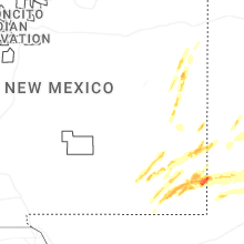
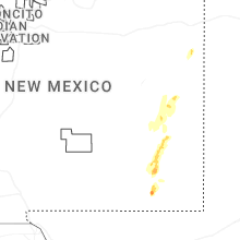


Connect with Interactive Hail Maps