

Hail Map for Sumter, SC August 2, 2012
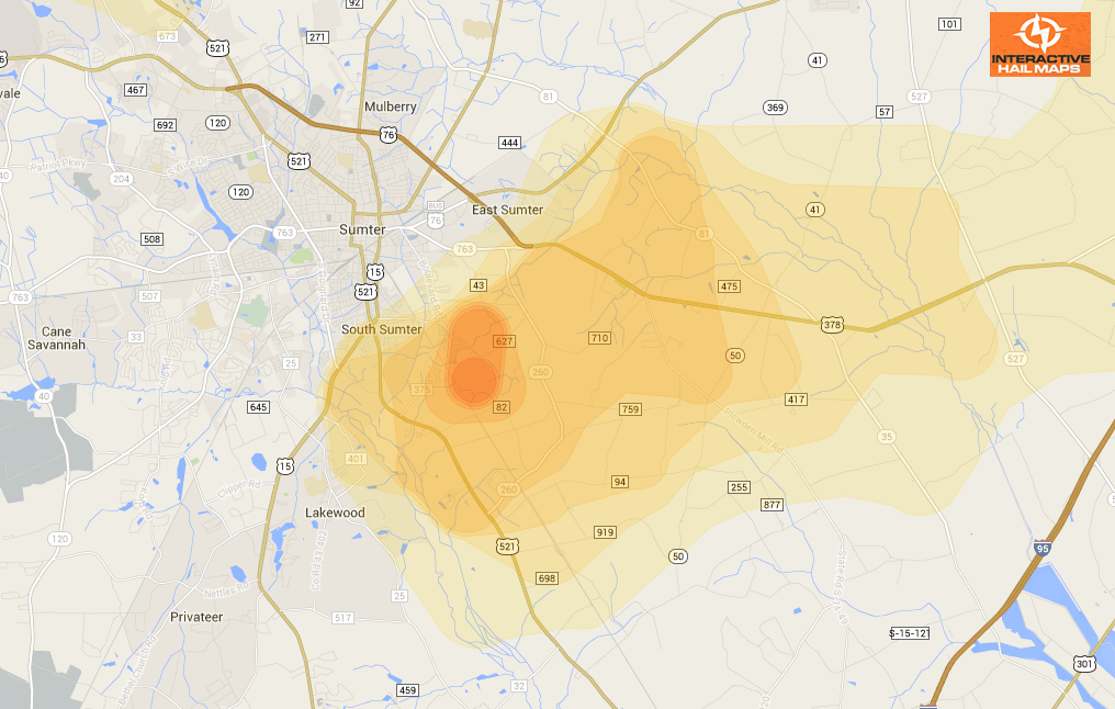
Here is a map for a hail storm that hit Sumter, SC on August 2, 2012. The Blue Marker is a 1.5″ hail report. The most intense hail hit on the south side of the city. Use Interactive Hail Maps to pinpoint hail locations live and zoom all the way to street view. Find the smaller hail storms others are missing.
Cities Most Affected by Hail Storms of 8/2/2012
| Hail Size | Demographics of Zip Codes Affected | ||||||
|---|---|---|---|---|---|---|---|
| City | Count | Average | Largest | Pop Density | House Value | Income | Age |
| Moncks Corner, SC | 2 | 2.13 | 2.50 | 195 | $97k | $35.8k | 37.6 |
| Green Pond, SC | 1 | 2.75 | 2.75 | 8 | $90k | $25.4k | 45.7 |
| Ridgeville, SC | 1 | 2.75 | 2.75 | 43 | $86k | $33.4k | 39.4 |
| Kelly, NC | 1 | 1.75 | 1.75 | 11 | $79k | $23.9k | 46.2 |
| Sundance, WY | 1 | 1.75 | 1.75 | 1 | $87k | $39.7k | 47.3 |
| Springfield, GA | 1 | 1.75 | 1.75 | 69 | $91k | $42.1k | 33.7 |
| Julesburg, CO | 1 | 1.75 | 1.75 | 6 | $62k | $28.8k | 48.8 |
| Monroe, NC | 1 | 1.75 | 1.75 | 400 | $117k | $45.4k | 34.1 |
| Kenly, NC | 1 | 1.75 | 1.75 | 98 | $81k | $32.4k | 38.8 |
| Otter, MT | 1 | 1.75 | 1.75 | 1 | $125k | $31.3k | 55.5 |
| Timmonsville, SC | 1 | 1.75 | 1.75 | 87 | $74k | $31.9k | 38.7 |
| Box Elder, SD | 1 | 1.75 | 1.75 | 45 | $66k | $32.6k | 30.1 |

Connect with Interactive Hail Maps