

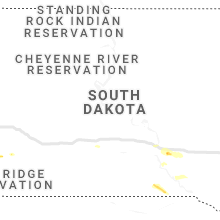
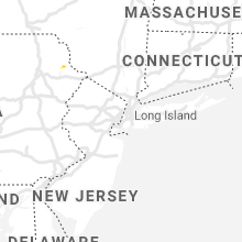
Hail Map for Friday, August 16, 2019

Number of Impacted Households on 8/16/2019
0
Impacted by 1" or Larger Hail
0
Impacted by 1.75" or Larger Hail
0
Impacted by 2.5" or Larger Hail
Square Miles of Populated Area Impacted on 8/16/2019
0
Impacted by 1" or Larger Hail
0
Impacted by 1.75" or Larger Hail
0
Impacted by 2.5" or Larger Hail
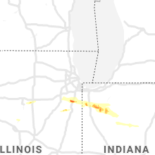


Cities Most Affected by Hail Storms of 8/16/2019
| Hail Size | Demographics of Zip Codes Affected | ||||||
|---|---|---|---|---|---|---|---|
| City | Count | Average | Largest | Pop Density | House Value | Income | Age |
| Sterling, CO | 1 | 2.50 | 2.50 | 31 | $91k | $32.2k | 37.3 |
| Peotone, IL | 1 | 1.75 | 1.75 | 75 | $157k | $58.0k | 40.0 |
| Hot Springs, SD | 1 | 1.75 | 1.75 | 11 | $63k | $30.3k | 50.7 |
Hail and Wind Damage Spotted on 8/16/2019
Filter by Report Type:Hail ReportsWind Reports
States Impacted
Pennsylvania, North Carolina, New York, South Carolina, Wyoming, Florida, Colorado, South Dakota, Nebraska, Illinois, Texas, Kansas, Oklahoma, Indiana, MissouriPennsylvania
| Local Time | Report Details |
|---|---|
| 4:02 PM EDT | Tree down with wires near elizabeth st and long ridge rd in wayne county PA, 25.3 miles ENE of Scranton, PA |
North Carolina
| Local Time | Report Details |
|---|---|
| 4:14 PM EDT | Tree down on n falls driv in wake county NC, 10.2 miles NNW of Raleigh, NC |
New York
| Local Time | Report Details |
|---|---|
| 5:43 PM EDT | Multiple trees down and powerline in niagara county NY, 20.6 miles N of Buffalo, NY |
| 5:45 PM EDT | Ping Pong Ball sized hail reported near Lockport, NY, 22.1 miles NNE of Buffalo, NY, quarter to ping pong size hail reported. |
| 5:47 PM EDT | Multiple trees down and wire on howlett rd and reported apple orchard had multiple trees uproote in orleans county NY, 37.8 miles NE of Buffalo, NY |
| 5:52 PM EDT | Quarter sized hail reported near , , 21.6 miles NNE of Buffalo, NY |
| 5:54 PM EDT | Downed tree and numerous limbs and branches also downed on hartman road in albany in albany county NY, 12.5 miles SSE of Schenectady, NY |
| 5:56 PM EDT | Large limbs down on wires on new scotland avenue in albany county NY, 12.4 miles SSE of Schenectady, NY |
| 5:56 PM EDT | Trees snapped... damage to multiple houses and cars in albany county NY, 13 miles SE of Schenectady, NY |
| 5:56 PM EDT | Quarter sized hail reported near Medina, NY, 37 miles NE of Buffalo, NY |
| 6:00 PM EDT | Tree down which took out electrical wires and then caught on fir in livingston county NY, 57.3 miles E of Buffalo, NY |
| 6:00 PM EDT | Multiple trees and wires down. some trees on cars and home in albany county NY, 13 miles SE of Schenectady, NY |
| 6:01 PM EDT | Large branches downed on myrtle avenue in albany county NY, 13 miles SE of Schenectady, NY |
| 6:01 PM EDT | Tree down in bakerside park r in orleans county NY, 46.4 miles NE of Buffalo, NY |
| 6:02 PM EDT | Large tree uprooted and crushed car in albany county NY, 13.6 miles SE of Schenectady, NY |
| 6:05 PM EDT | Power pole snapped and wires dow in orleans county NY, 43.5 miles NE of Buffalo, NY |
| 6:05 PM EDT | Transformer blew... knocking power lines down. power lines caught fire on ground and burned wten studio sig in albany county NY, 13.8 miles SE of Schenectady, NY |
| 6:08 PM EDT | Tree down blocking n. pearl st and lindbergh av in albany county NY, 13.7 miles SE of Schenectady, NY |
| 6:10 PM EDT | Rt4 n/s closed due to downed tree in rensselaer county NY, 15.7 miles SE of Schenectady, NY |
| 6:11 PM EDT | Power pole snapped and wires down on sunset beach r in orleans county NY, 45.8 miles NE of Buffalo, NY |
| 6:12 PM EDT | About a 1 mile strech of damage from stonegate apartments through the winter street extension including many trees snapped and uprooted... wires down... and plastic roo in rensselaer county NY, 16.1 miles SE of Schenectady, NY |
| 6:12 PM EDT | Multiple trees snapped and uprooted in rensselaer county NY, 15.7 miles ESE of Schenectady, NY |
| 6:12 PM EDT | Many trees snapped in half and sheared off at the top... some trees uprooted... some powerlines down... some street signs bent in half and pulled out of groun in albany county NY, 14.1 miles SE of Schenectady, NY |
| 6:12 PM EDT | Wires down and window blown out at cottage street apartments in troy in rensselaer county NY, 14.9 miles ESE of Schenectady, NY |
| 6:12 PM EDT | Large tree down blocking 2 lanes of traffic on rt378 in rensselaer county NY, 14.5 miles ESE of Schenectady, NY |
| 6:12 PM EDT | Large tree uprooted in albany county NY, 13.7 miles SE of Schenectady, NY |
| 6:22 PM EDT | Barn collapse... knowlesville r in orleans county NY, 37.8 miles NE of Buffalo, NY |
| 6:24 PM EDT | Quarter sized hail reported near Averill Park, NY, 20.1 miles ESE of Schenectady, NY, estimated from picture |
| 7:05 PM EDT | Wires dow in ontario county NY, 63.6 miles W of Syracuse, NY |
| 7:15 PM EDT | Wires dow in ontario county NY, 59.9 miles W of Syracuse, NY |
| 7:22 PM EDT | Barn collapse... knowlesville r in orleans county NY, 37.8 miles NE of Buffalo, NY |
| 7:47 PM EDT | Tree down at spring lake rd and nys route 38. relayed by wfo bg in cayuga county NY, 25.7 miles W of Syracuse, NY |
| 7:57 PM EDT | Trees down at lemon school rd and emerson rd. relayed by wfo bg in cayuga county NY, 23.2 miles W of Syracuse, NY |
| 8:30 PM EDT | Numerous reports of trees down in scipio center are in cayuga county NY, 26.9 miles SW of Syracuse, NY |
South Carolina
| Local Time | Report Details |
|---|---|
| 6:00 PM EDT | Multiple power outages reported with possible tree limbs down on power lines. time estimated by rada in kershaw county SC, 64 miles SSE of Charlotte, NC |
Wyoming
| Local Time | Report Details |
|---|---|
| 4:00 PM MDT | Lone tree wydot mesonet observation in albany county WY, 18 miles SE of Laramie, WY |
| 4:02 PM MDT | Measured using a vantage pro 2 davis weather sensor sighted 30 feet above groun in albany county WY, 6.5 miles SSE of Laramie, WY |
| 4:21 PM MDT | Storm damage reported in laramie county WY, 26.4 miles E of Laramie, WY |
| 5:11 PM MDT | Mesonet station wy37 1 ese buford - buford east - bf in albany county WY, 20.8 miles SE of Laramie, WY |
Florida
| Local Time | Report Details |
|---|---|
| 6:54 PM EDT | Indian shores beac in pinellas county FL, 30.1 miles NNW of Bradenton, FL |
Colorado
| Local Time | Report Details |
|---|---|
| 5:17 PM MDT | Half Dollar sized hail reported near Otis, CO, 11.2 miles NNW of Yuma, CO |
| 6:55 PM MDT | Ping Pong Ball sized hail reported near Eads, CO, 102.1 miles ENE of Pueblo, CO |
| 7:00 PM MDT | Tennis Ball sized hail reported near Sterling, CO, 54.3 miles NNW of Yuma, CO |
| 7:14 PM MDT | Half Dollar sized hail reported near Sterling, CO, 50.1 miles NNW of Yuma, CO |
| 7:36 PM MDT | Quarter sized hail reported near Hillrose, CO, 44 miles WNW of Yuma, CO |
| 9:43 PM MDT | Asos station kitr burlington co airpor in kit carson county CO, 65.7 miles SSE of Yuma, CO |
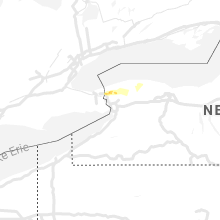
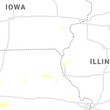
South Dakota
| Local Time | Report Details |
|---|---|
| 5:50 PM MDT | Quarter sized hail reported near Edgemont, SD, 64.4 miles SSW of Rapid City, SD |
| 6:45 PM MDT | Quarter sized hail reported near Hot Springs, SD, 47.3 miles SSW of Rapid City, SD |
| 6:45 PM MDT | Quarter sized hail reported near Hot Springs, SD, 47.1 miles SSW of Rapid City, SD, fell on fall river road. quantity made the road quite slick. |
| 6:50 PM MDT | Golf Ball sized hail reported near Hot Springs, SD, 48.6 miles S of Rapid City, SD |
| 11:52 PM CDT | Quarter sized hail reported near Chamberlain, SD, 63.8 miles SE of Pierre, SD, nickel to quarter size hail reported in chamberlain. |
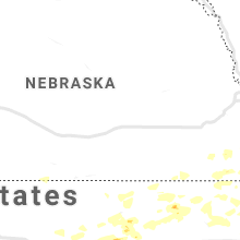
Nebraska
| Local Time | Report Details |
|---|---|
| 5:57 PM MDT | Quarter sized hail reported near Kimball, NE, 57.7 miles S of Scottsbluff, NE |
| 6:28 PM MDT | Quarter sized hail reported near Scottsbluff, NE, 1.4 miles NNE of Scottsbluff, NE |
| 6:28 PM MDT | Quarter sized hail reported near Scottsbluff, NE, 0.9 miles NE of Scottsbluff, NE, caller from the northeastern side of scottsbluff reported two separate rounds of quarter size hail with the initial being at 628 pm. |
| 6:30 PM MDT | Quarter sized hail reported near Scottsbluff, NE, 1.4 miles NNE of Scottsbluff, NE |
| 8:25 PM MDT | Quarter sized hail reported near Hyannis, NE, 77.6 miles SW of Valentine, NE, mostly pea size hail but some stones up to quarter size |
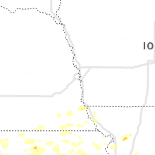
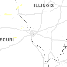
Illinois
| Local Time | Report Details |
|---|---|
| 7:09 PM CDT | Numerous 3-inch tree limbs blown down and corn was flattened near the interesection of 2300 e and 800 n in woodford county IL, 25.6 miles E of Peoria, IL |
| 7:15 PM CDT | Quarter sized hail reported near Utica, IL, 54 miles NNE of Peoria, IL, corrected time of report. |
| 7:27 PM CDT | Quarter sized hail reported near Utica, IL, 54 miles NNE of Peoria, IL |
| 2:30 AM CDT | Storm damage reported in will county IL, 39.2 miles SSW of Chicago, IL |
| 2:30 AM CDT | Ping Pong Ball sized hail reported near Peotone, IL, 39.2 miles SSW of Chicago, IL |
| 2:36 AM CDT | Golf Ball sized hail reported near Peotone, IL, 39.2 miles SSW of Chicago, IL |
| 2:36 AM CDT | Storm damage reported in will county IL, 39.2 miles SSW of Chicago, IL |
| 2:37 AM CDT | Quarter sized hail reported near Peotone, IL, 39.1 miles SSW of Chicago, IL |
| 2:54 AM CDT | Multiple 6 inch diameter branches snapped off healthy trees. 2 foot diameter tree downed. report relayed via ham operator on nwscha in kankakee county IL, 44.5 miles S of Chicago, IL |
Texas
| Local Time | Report Details |
|---|---|
| 7:35 PM CDT | Storm damage reported in gray county TX, 54.6 miles ENE of Amarillo, TX |
| 11:37 PM CDT | Storm damage reported in hemphill county TX, 60.7 miles SW of Woodward, OK |
| 3:15 AM CDT | Storm damage reported in donley county TX, 53.1 miles NW of Childress, TX |
| 5:10 AM CDT | Storm damage reported in gray county TX, 56 miles ENE of Amarillo, TX |
Kansas
| Local Time | Report Details |
|---|---|
| 11:45 PM CDT | Asos station kp28 medicine lodg in barber county KS, 72.4 miles WSW of Wichita, KS |
| 11:46 PM CDT | Quarter sized hail reported near Topeka, KS, 44.7 miles ESE of Manhattan, KS |
| 11:52 PM CDT | Ping Pong Ball sized hail reported near Hays, KS, 0.4 miles W of Hays, KS, hail reported on social media at fort hays state campus. |
| 12:00 AM CDT | Ping Pong Ball sized hail reported near Topeka, KS, 41.6 miles E of Manhattan, KS |
| 12:15 AM CDT | Quarter sized hail reported near Topeka, KS, 45.3 miles E of Manhattan, KS |
| 12:29 AM CDT | Half Dollar sized hail reported near Topeka, KS, 50.6 miles E of Manhattan, KS, at nws topeka. |
| 12:34 AM CDT | Quarter sized hail reported near Mc Louth, KS, 35.3 miles W of Kansas City, MO, k-16 and washington road. |
| 12:38 AM CDT | Quarter sized hail reported near Berryton, KS, 53.4 miles ESE of Manhattan, KS |
| 12:40 AM CDT | Quarter sized hail reported near Mc Louth, KS, 30.8 miles WNW of Kansas City, MO |
| 12:50 AM CDT | Quarter sized hail reported near Topeka, KS, 52.1 miles ESE of Manhattan, KS |
| 12:53 AM CDT | Storm damage reported in riley county KS, 27.9 miles NW of Manhattan, KS |
| 1:05 AM CDT | Several power lines down in the town of riley along with large healthy tree in riley county KS, 16.6 miles WNW of Manhattan, KS |
| 1:10 AM CDT | Measured with a garmin instrumen in riley county KS, 20.3 miles NNW of Manhattan, KS |
| 1:15 AM CDT | Quarter sized hail reported near Garnett, KS, 39.5 miles NNE of Chanute, KS |
| 1:24 AM CDT | Storm damage reported in nemaha county KS, 43.7 miles NE of Manhattan, KS |
| 1:36 AM CDT | Asos station krsl russell municipal airpor in russell county KS, 27.6 miles E of Hays, KS |
| 1:37 AM CDT | Storm damage reported in jefferson county KS, 45.5 miles W of Kansas City, MO |
| 1:41 AM CDT | Storm damage reported in jefferson county KS, 43.4 miles W of Kansas City, MO |
| 1:58 AM CDT | Measured at hays airpor in ellis county KS, 3.2 miles ESE of Hays, KS |
| 1:58 AM CDT | Storm damage reported in jackson county KS, 42.4 miles ENE of Manhattan, KS |
| 1:59 AM CDT | 12 inch diameter tree down at us 59 and 35th roa in jefferson county KS, 40.1 miles W of Kansas City, MO |
| 2:04 AM CDT | Quarter sized hail reported near Mc Louth, KS, 35.9 miles W of Kansas City, MO |
| 2:07 AM CDT | Half Dollar sized hail reported near Oskaloosa, KS, 39.9 miles WNW of Kansas City, MO |
| 2:10 AM CDT | Mesonet station k5wkr 2 nw victori in ellis county KS, 8.2 miles E of Hays, KS |
| 2:15 AM CDT | Ping Pong Ball sized hail reported near Mc Louth, KS, 35.3 miles W of Kansas City, MO |
| 2:20 AM CDT | Mesonet station k5wky 1 ssw wakeene in trego county KS, 31 miles WNW of Hays, KS |
| 2:25 AM CDT | Asos station krsl russell municipal airpor in russell county KS, 27.6 miles E of Hays, KS |
| 2:37 AM CDT | Large diameter tree snapped. via social medi in shawnee county KS, 45.3 miles ESE of Manhattan, KS |
| 2:49 AM CDT | Stop sign blown awa in jefferson county KS, 45.5 miles W of Kansas City, MO |
| 2:50 AM CDT | Storm damage reported in jefferson county KS, 39.9 miles WNW of Kansas City, MO |
| 2:51 AM CDT | Storm damage reported in rooks county KS, 32.4 miles NNE of Hays, KS |
| 2:57 AM CDT | Asos station klwc lawrenc in douglas county KS, 34.7 miles W of Kansas City, MO |
| 3:27 AM CDT | Power lines down at bridge and main in perr in jefferson county KS, 43.9 miles W of Kansas City, MO |
| 3:28 AM CDT | Power lines down in ottaw in franklin county KS, 49.8 miles SW of Kansas City, MO |
| 3:33 AM CDT | 59 mph wind gust at kix in johnson county KS, 25.9 miles SW of Kansas City, MO |
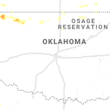
Oklahoma
| Local Time | Report Details |
|---|---|
| 12:35 AM CDT | Storm damage reported in woods county OK, 43.7 miles NNE of Woodward, OK |
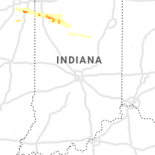
Indiana
| Local Time | Report Details |
|---|---|
| 3:30 AM CDT | Trained spotter reports branches down and estimated 60 mph wind gusts in demott in jasper county IN, 52.9 miles SSE of Chicago, IL |
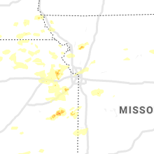
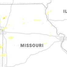
Missouri
| Local Time | Report Details |
|---|---|
| 5:00 AM CDT | Many large trees dow in johnson county MO, 50.9 miles ESE of Kansas City, MO |
| 5:15 AM CDT | Whiteman afb measured 68 mph wind gust in johnson county MO, 61.3 miles ESE of Kansas City, MO |
| 5:25 AM CDT | Winds still over 60 mph at whiteman af in johnson county MO, 60.8 miles ESE of Kansas City, MO |
| 5:39 AM CDT | Sedalia airport measured wind gus in pettis county MO, 48.1 miles WSW of Columbia, MO |
| 5:43 AM CDT | Sedalia regional airpor in pettis county MO, 48.6 miles WSW of Columbia, MO |
Connect with Interactive Hail Maps