

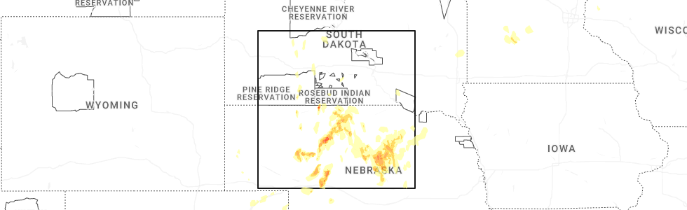
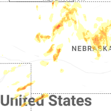
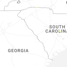
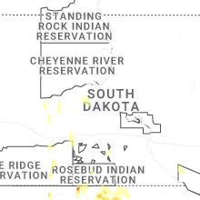
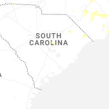
Hail Map for Wednesday, May 14, 2025
Number of Impacted Households on 5/14/2025
0
Impacted by 1" or Larger Hail
0
Impacted by 1.75" or Larger Hail
0
Impacted by 2.5" or Larger Hail
Square Miles of Populated Area Impacted on 5/14/2025
0
Impacted by 1" or Larger Hail
0
Impacted by 1.75" or Larger Hail
0
Impacted by 2.5" or Larger Hail
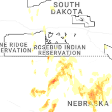
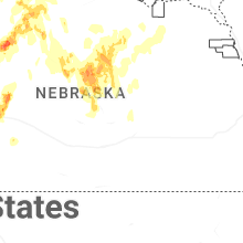

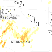
Cities Most Affected by Hail Storms of 5/14/2025
| Hail Size | Demographics of Zip Codes Affected | ||||||
|---|---|---|---|---|---|---|---|
| City | Count | Average | Largest | Pop Density | House Value | Income | Age |
| Hershey, NE | 3 | 2.00 | 2.50 | 4 | $78k | $42.2k | 42.2 |
| Burwell, NE | 3 | 2.00 | 2.50 | 1 | $39k | $26.8k | 50.4 |
| Wellfleet, NE | 2 | 1.75 | 1.75 | 1 | $85k | $37.1k | 45.3 |
| Scottsbluff, NE | 1 | 1.75 | 1.75 | 157 | $75k | $31.0k | 37.9 |
| Mullen, NE | 1 | 1.75 | 1.75 | 0 | $41k | $28.7k | 49.6 |
| Nenzel, NE | 1 | 1.75 | 1.75 | 0 | $28k | $46.3k | 38.0 |
| North Platte, NE | 1 | 1.75 | 1.75 | 50 | $79k | $36.3k | 38.7 |
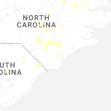
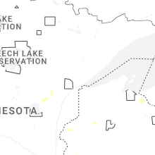
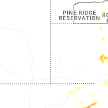
Hail and Wind Damage Spotted on 5/14/2025
Filter by Report Type:Hail ReportsWind Reports
States Impacted
North Carolina, Virginia, Nebraska, Colorado, South Carolina, Kansas, South Dakota, MinnesotaNorth Carolina
| Local Time | Report Details |
|---|---|
| 12:20 PM EDT | Tree downed by thunderstorm winds on quick roa in caswell county NC, 62.7 miles SSE of Roanoke, VA |
| 12:45 PM EDT | Tree downed by thunderstorm winds on slade roa in caswell county NC, 59.3 miles NW of Raleigh, NC |
| 12:50 PM EDT | Tree downed by thunderstorm winds on blanch roa in caswell county NC, 61.6 miles NW of Raleigh, NC |
| 1:05 PM EDT | Tree downed by thunderstorm winds on culver roa in caswell county NC, 61 miles NNW of Raleigh, NC |
| 2:28 PM EDT | Damage to utility equipment from falling tree in caldwell county NC, 57.4 miles NW of Charlotte, NC |
| 2:31 PM EDT | Quarter sized hail reported near Valdese, NC, 55.9 miles NW of Charlotte, NC, time estimated from radar. |
| 3:20 PM EDT | Trees and power lines dow in harnett county NC, 25.3 miles S of Raleigh, NC |
| 4:00 PM EDT | Quarter sized hail reported near Dunn, NC, 35.6 miles S of Raleigh, NC, picture of quarter sized hail received. time estimated based on radar. |
| 4:38 PM EDT | Tree down across ward rd near us 1 in hertford county NC, 60.5 miles SW of Virginia Beach, VA |
| 6:23 PM EDT | Duplin county 911 reported trees down near the intersection of fussell rd and corinth church rd. time based on rada in duplin county NC, 38.3 miles NNW of Wilmington, NC |
Virginia
| Local Time | Report Details |
|---|---|
| 12:20 PM EDT | Tree down along cascade mill road... near its intersection with loblolly drive. time estimated from rada in pittsylvania county VA, 49.8 miles SSE of Roanoke, VA |
| 1:10 PM EDT | Tree down blocking graves bridge road. time estimated from rada in pittsylvania county VA, 29.5 miles SE of Roanoke, VA |
| 1:30 PM EDT | Tree down blocking cherrystone lake road... near its intersection with hodnetts mill road. time estimated from rada in pittsylvania county VA, 40.5 miles SE of Roanoke, VA |
| 1:30 PM EDT | Tree downed by thunderstorm winds at the intersection of double bridge road and callands road... blocking the roa in pittsylvania county VA, 38.8 miles SE of Roanoke, VA |
| 2:15 PM EDT | Report of a tree down on hwy 4 in mecklenburg county VA, 54.1 miles N of Raleigh, NC |
| 2:37 PM EDT | Reports of numerous trees and power lines down in an around clarksvill in mecklenburg county VA, 57.7 miles N of Raleigh, NC |
| 5:50 PM EDT | Tree down across brownsview lane near beechland rd. time estimated via rada in surry county VA, 49.5 miles WNW of Virginia Beach, VA |
Nebraska
| Local Time | Report Details |
|---|---|
| 2:32 PM MDT | Golf Ball sized hail reported near Nenzel, NE, 28.1 miles W of Valentine, NE |
| 4:06 PM MDT | Golf Ball sized hail reported near Mullen, NE, 47.7 miles SSW of Valentine, NE |
| 4:30 PM MDT | Quarter sized hail reported near Mullen, NE, 62.9 miles SSW of Valentine, NE |
| 5:33 PM CDT | Quarter sized hail reported near Ansley, NE, 54.6 miles WNW of Grand Island, NE |
| 4:55 PM MDT | Storm damage reported in kimball county NE, 43.6 miles S of Scottsbluff, NE |
| 5:58 PM CDT | Report of an overturned semi on highway 83 mm 17 in cherry county NE, 36.9 miles S of Valentine, NE |
| 5:11 PM MDT | Half Dollar sized hail reported near Scottsbluff, NE, 5.4 miles N of Scottsbluff, NE |
| 5:11 PM MDT | Golf Ball sized hail reported near Scottsbluff, NE, 1.3 miles N of Scottsbluff, NE |
| 5:34 PM MDT | Bff raws sit in scotts bluff county NE, 3.3 miles SW of Scottsbluff, NE |
| 6:40 PM CDT | Golf Ball sized hail reported near Wellfleet, NE, 28.1 miles S of North Platte, NE |
| 5:51 PM MDT | Storm damage reported in cheyenne county NE, 62 miles SE of Scottsbluff, NE |
| 5:53 PM MDT | Upr sit in cheyenne county NE, 54 miles SSE of Scottsbluff, NE |
| 6:57 PM CDT | Golf Ball sized hail reported near Wellfleet, NE, 25.3 miles S of North Platte, NE |
| 6:04 PM MDT | Sunol upr sit in cheyenne county NE, 66.3 miles SE of Scottsbluff, NE |
| 7:27 PM CDT | Golf Ball sized hail reported near Burwell, NE, 57.2 miles SW of Oneill, NE |
| 6:30 PM MDT | Storm damage reported in garden county NE, 73.8 miles ESE of Scottsbluff, NE |
| 6:33 PM MDT | Storm damage reported in garden county NE, 76.6 miles SE of Scottsbluff, NE |
| 6:34 PM MDT | Storm damage reported in garden county NE, 76.2 miles ESE of Scottsbluff, NE |
| 6:35 PM MDT | Storm damage reported in deuel county NE, 69.6 miles N of Yuma, CO |
| 6:35 PM MDT | Storm damage reported in cheyenne county NE, 62 miles SE of Scottsbluff, NE |
| 7:35 PM CDT | Golf Ball sized hail reported near Hershey, NE, 12.4 miles W of North Platte, NE |
| 6:39 PM MDT | Storm damage reported in garden county NE, 76 miles W of North Platte, NE |
| 6:46 PM MDT | Storm damage reported in garden county NE, 76 miles W of North Platte, NE |
| 6:48 PM MDT | Weatherlink statio in phillips county CO, 47.7 miles NE of Yuma, CO |
| 6:49 PM MDT | Storm damage reported in deuel county NE, 63.4 miles NNE of Yuma, CO |
| 7:50 PM CDT | Tennis Ball sized hail reported near Hershey, NE, 13.4 miles NW of North Platte, NE |
| 6:52 PM MDT | Storm damage reported in deuel county NE, 69.7 miles W of North Platte, NE |
| 7:57 PM CDT | Half Dollar sized hail reported near Burwell, NE, 53.9 miles SSW of Oneill, NE |
| 8:00 PM CDT | Quarter sized hail reported near Comstock, NE, 63.7 miles NW of Grand Island, NE, hail up to quarter size...most smaller. |
| 8:01 PM CDT | Golf Ball sized hail reported near Hershey, NE, 10.3 miles W of North Platte, NE |
| 8:03 PM CDT | Quarter sized hail reported near Burwell, NE, 54.7 miles SW of Oneill, NE |
| 8:04 PM CDT | Golf Ball sized hail reported near Burwell, NE, 52.9 miles SSW of Oneill, NE |
| 8:05 PM CDT | Quarter sized hail reported near Burwell, NE, 52.4 miles SSW of Oneill, NE |
| 7:08 PM MDT | Storm damage reported in chase county NE, 54 miles SW of North Platte, NE |
| 8:10 PM CDT | Half Dollar sized hail reported near Burwell, NE, 56.9 miles SSW of Oneill, NE, hail up to half dollar size...most smaller. report less than a mile south of garfield county line. |
| 7:12 PM MDT | Storm damage reported in chase county NE, 62.2 miles SW of North Platte, NE |
| 8:12 PM CDT | Golf Ball sized hail reported near North Platte, NE, 4.2 miles NW of North Platte, NE |
| 7:15 PM MDT | Storm damage reported in perkins county NE, 53.8 miles WSW of North Platte, NE |
| 7:15 PM MDT | Building damage and power poles snapped in imperia in chase county NE, 62.6 miles SW of North Platte, NE |
| 7:18 PM MDT | Storm damage reported in chase county NE, 62.5 miles SW of North Platte, NE |
| 8:21 PM CDT | Ping Pong Ball sized hail reported near Burwell, NE, 56.3 miles SSW of Oneill, NE, hail up to ping pong ball size...most smaller. |
| 7:23 PM MDT | Storm damage reported in chase county NE, 55.4 miles SW of North Platte, NE |
| 8:28 PM CDT | Half Dollar sized hail reported near Ord, NE, 59.4 miles NW of Grand Island, NE, hail up to half dollar size...more flat than round. |
| 7:30 PM MDT | Multiple 4 inch limbs down from trees during thunderstor in keith county NE, 49.9 miles W of North Platte, NE |
| 7:31 PM MDT | Storm damage reported in keith county NE, 46.9 miles W of North Platte, NE |
| 8:33 PM CDT | Storm damage reported in hayes county NE, 36 miles SSW of North Platte, NE |
| 8:39 PM CDT | Quarter sized hail reported near Ord, NE, 59.4 miles NW of Grand Island, NE, hail to around quarter size...second round of hail in last 11 minutes from a new core. |
| 8:47 PM CDT | Half Dollar sized hail reported near Burwell, NE, 56.9 miles SSW of Oneill, NE, at least the third round of hail in 45 minutes. |
| 8:50 PM CDT | Lorens farms... ambient weathe in hitchcock county NE, 44.8 miles NNW of Colby, KS |
| 9:01 PM CDT | Storm damage reported in lincoln county NE, 19.8 miles W of North Platte, NE |
| 9:04 PM CDT | Wnw trenton. 3w 1n trenton... ne - knetrent7 (corrected time in hitchcock county NE, 54.7 miles N of Colby, KS |
| 9:08 PM CDT | Storm damage reported in lincoln county NE, 15.2 miles SSW of North Platte, NE |
| 9:08 PM CDT | Tennis Ball sized hail reported near Burwell, NE, 49.2 miles SSW of Oneill, NE, report with photos. time estimated from radar. |
| 9:12 PM CDT | Visibility reported of 100 yards with estimated wind gusts of 60 mph as wall of dust moves through. time provided by spotte in hitchcock county NE, 58.5 miles N of Colby, KS |
| 9:19 PM CDT | 3w 1n trenton... ne - knetrent in hitchcock county NE, 54.7 miles N of Colby, KS |
| 9:27 PM CDT | Asos station kmck mccook airport. visibility down to 1/2 mile due to dus in red willow county NE, 60.7 miles NNE of Colby, KS |
| 9:31 PM CDT | Report of 68 mph gust from pw in red willow county NE, 66.9 miles NNE of Colby, KS |
| 9:45 PM CDT | Intense outflow from combo of synoptic front and convective outflo in dawson county NE, 33.3 miles ESE of North Platte, NE |
| 9:55 PM CDT | At cambridge airport. intense outflow from combo of synoptic front and convective outflo in furnas county NE, 65.8 miles SSE of North Platte, NE |
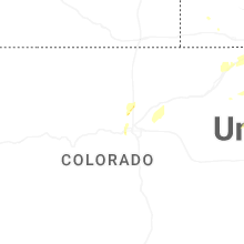
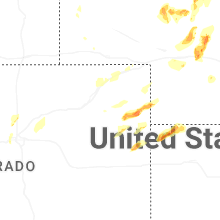
Colorado
| Local Time | Report Details |
|---|---|
| 3:16 PM MDT | Quarter sized hail reported near Erie, CO, 20.9 miles N of Denver, CO, report from mping: quarter (1.00 in.). |
| 3:20 PM MDT | Quarter sized hail reported near Erie, CO, 21.5 miles N of Denver, CO |
| 3:21 PM MDT | Half Dollar sized hail reported near Erie, CO, 20.9 miles N of Denver, CO, report from mping: half dollar (1.25 in.). |
| 3:29 PM MDT | Quarter sized hail reported near Erie, CO, 24.2 miles N of Denver, CO, report from mping: quarter (1.00 in.). |
| 4:07 PM MDT | Raws station tt567 crow cree in weld county CO, 71.6 miles NNE of Denver, CO |
| 4:14 PM MDT | Asos station kden denver intl airpor in denver county CO, 19.7 miles ENE of Denver, CO |
| 4:18 PM MDT | Weatherlink statio in weld county CO, 43.2 miles ENE of Denver, CO |
| 4:23 PM MDT | Awos station k1ow 2 nw pawnee butte in weld county CO, 70 miles SSW of Scottsbluff, NE |
| 4:25 PM MDT | Mesonet station co222 dearfiel in weld county CO, 54.3 miles NE of Denver, CO |
| 4:28 PM MDT | Measured with vantagepro weather station. also reported 3-4 inch diameter tree limbs down and minor roof damage to outbuildin in morgan county CO, 66.1 miles WNW of Yuma, CO |
| 4:51 PM MDT | Mesonet station co039 wiggins bijou cree in morgan county CO, 61.6 miles NE of Denver, CO |
| 4:51 PM MDT | Wunderground station pws-kcofortm5 in morgan county CO, 63.7 miles W of Yuma, CO |
| 4:55 PM MDT | Awos station kfmm fort morga in morgan county CO, 58.8 miles WNW of Yuma, CO |
| 5:10 PM MDT | Power poles down near the intersection of county road 25 and county road r. time estimate in morgan county CO, 51.4 miles W of Yuma, CO |
| 5:12 PM MDT | Multiple 3-4 inch diameter tree limbs down. time estimate in morgan county CO, 49 miles WNW of Yuma, CO |
| 5:12 PM MDT | Weatherlink statio in morgan county CO, 46.5 miles W of Yuma, CO |
| 5:13 PM MDT | Spotter and social media posts of at least one tree down on a house in brush. time and location estimate in morgan county CO, 49.5 miles WNW of Yuma, CO |
| 5:15 PM MDT | Awos station kstk sterlin in logan county CO, 45.1 miles NW of Yuma, CO |
| 5:15 PM MDT | Mesonet station bru01 brus in washington county CO, 34.8 miles WNW of Yuma, CO |
| 5:17 PM MDT | Weatherlink statio in washington county CO, 46.8 miles W of Yuma, CO |
| 5:23 PM MDT | Awos station kako akro in washington county CO, 26.6 miles W of Yuma, CO |
| 5:32 PM MDT | Awos station k1mw sterling 15 wn in logan county CO, 56.6 miles NW of Yuma, CO |
| 5:33 PM MDT | Awos station kako akro in washington county CO, 26.6 miles W of Yuma, CO |
| 5:41 PM MDT | Awos station k1jw peet in logan county CO, 63.9 miles NNW of Yuma, CO |
| 5:45 PM MDT | Coagmet station csu67 ilif in logan county CO, 48.1 miles NNW of Yuma, CO |
| 5:49 PM MDT | Weatherlink statio in logan county CO, 57.2 miles NW of Yuma, CO |
| 5:50 PM MDT | Power line down by county road 55 north of iliff. spotter also reported no power in town. location and time estimate in logan county CO, 49 miles NNW of Yuma, CO |
| 6:04 PM MDT | Corrects previous tstm wnd gst report from 8 nnw flagler. wunderground site kcoflagl1 in kit carson county CO, 54.7 miles SSW of Yuma, CO |
| 6:04 PM MDT | Wunderground site kcoflagl1 in kit carson county CO, 54.7 miles SSW of Yuma, CO |
| 6:08 PM MDT | Weatherlink statio in washington county CO, 33.2 miles SSW of Yuma, CO |
| 6:10 PM MDT | Site rmr ranch reports wind gust of 58 mp in yuma county CO, 9 miles SSE of Yuma, CO |
| 6:15 PM MDT | Site kcoflagl2 reports 61 mph wind gust with thunderstorms in are in kit carson county CO, 58.6 miles SSW of Yuma, CO |
| 6:21 PM MDT | Ambient weather site struckmeye in yuma county CO, 25.9 miles NE of Yuma, CO |
| 6:26 PM MDT | Awn site broph in yuma county CO, 27.5 miles NE of Yuma, CO |
| 6:29 PM MDT | Wxunderground kcovona in kit carson county CO, 56.5 miles S of Yuma, CO |
| 6:29 PM MDT | Weatherlink statio in sedgwick county CO, 47.7 miles NNE of Yuma, CO |
| 6:30 PM MDT | Storm damage reported in kit carson county CO, 49.2 miles S of Yuma, CO |
| 6:37 PM MDT | Wunderground station pws-kcohaxtu2 in phillips county CO, 28 miles N of Yuma, CO |
| 6:43 PM MDT | Kcoflagl13 64 mph gus in kit carson county CO, 54.7 miles SSW of Yuma, CO |
| 6:43 PM MDT | Mesonet station co048 us 385 holyok in phillips county CO, 33 miles NE of Yuma, CO |
| 6:44 PM MDT | Ambient weather station my_weather_station in yuma county CO, 33.9 miles ESE of Yuma, CO |
| 6:45 PM MDT | County dispatch reported two trees down on houses within holyoke... along with other tree damage and power outages. time estimate in phillips county CO, 38.9 miles NE of Yuma, CO |
| 6:46 PM MDT | Weatherlink statio in sedgwick county CO, 55.2 miles NNE of Yuma, CO |
| 6:47 PM MDT | Mesonet station ew7003 17 n flagle in kit carson county CO, 43.6 miles SSW of Yuma, CO |
| 6:47 PM MDT | Weatherlink statio in phillips county CO, 34.7 miles NNE of Yuma, CO |
| 6:47 PM MDT | Weatherlink statio in phillips county CO, 41.8 miles NE of Yuma, CO |
| 6:50 PM MDT | Weatherlink statio in phillips county CO, 47.2 miles NE of Yuma, CO |
| 6:53 PM MDT | Mesonet station co048 us 385 holyok in phillips county CO, 33 miles NE of Yuma, CO |
| 6:55 PM MDT | Awos station kheq holyoke airpor in phillips county CO, 39 miles NE of Yuma, CO |
| 6:57 PM MDT | Reported via social media. estimated 60 mph winds with under half mile visibility due to dus in kit carson county CO, 60.8 miles SSE of Yuma, CO |
| 6:59 PM MDT | Quarter sized hail reported near Wray, CO, 26.6 miles ENE of Yuma, CO, delayed report. |
| 7:03 PM MDT | Asos station kitr burlington co airpor in kit carson county CO, 65.7 miles SSE of Yuma, CO |
| 7:10 PM MDT | Storm damage reported in kit carson county CO, 65 miles SSE of Yuma, CO |
| 7:15 PM MDT | Up69 in cheyenne county CO, 71.7 miles WSW of Colby, KS |
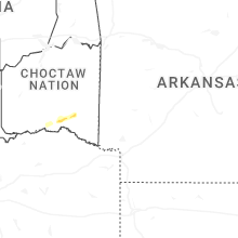
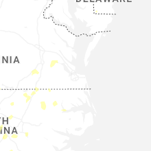
South Carolina
| Local Time | Report Details |
|---|---|
| 5:25 PM EDT | Quarter sized hail reported near Manning, SC, 36.5 miles NNW of Charleston, SC, spotter report of quarter sized hail in manning. |
Kansas
| Local Time | Report Details |
|---|---|
| 7:05 PM CDT | Ks mesonet cheyenne reported 60 mph gust at 10 meter in cheyenne county KS, 43.9 miles WNW of Colby, KS |
| 7:59 PM CDT | Half Dollar sized hail reported near Saint Francis, KS, 48.2 miles WNW of Colby, KS, reported via social media. quarter to half dollar sized hail measured. |
| 8:00 PM CDT | Half Dollar sized hail reported near Saint Francis, KS, 47.8 miles WNW of Colby, KS, report from mping: half dollar (1.25 in.). |
| 7:05 PM MDT | Leonard farms - kkskanor in sherman county KS, 48.1 miles W of Colby, KS |
| 8:10 PM CDT | Em relayed report of a tree powerline. time is estimate in cheyenne county KS, 47.7 miles NW of Colby, KS |
| 8:12 PM CDT | Reported via social media. time reported via weather statio in cheyenne county KS, 38.5 miles WNW of Colby, KS |
| 7:15 PM MDT | Off duty nws employee reports a moderately healthy 8 to 12 inch diameter branch snapped. estimated tim in sherman county KS, 35.8 miles W of Colby, KS |
| 8:30 PM CDT | Estimated 60 mph gust with very small tree branches down. a lot of pea sized hail also reported. time provided by spotte in cheyenne county KS, 42.7 miles NW of Colby, KS |
| 8:37 PM CDT | Reported via social media. estimated at least 60 mp in cheyenne county KS, 43.6 miles NW of Colby, KS |
| 8:41 PM CDT | St francis airport kkssaint2 in cheyenne county KS, 47.4 miles WNW of Colby, KS |
| 8:45 PM CDT | Trained spotter reports 70 mph wind gusts. wind gusts were down to 60 mph as of 8:55pm c in rawlins county KS, 30.9 miles N of Colby, KS |
| 7:45 PM MDT | Off-duty employee reported. time via weather statio in sherman county KS, 21.8 miles WNW of Colby, KS |
| 8:48 PM CDT | Ambient weathe in cheyenne county KS, 40.3 miles NNW of Colby, KS |
| 8:55 PM CDT | K state mesone in rawlins county KS, 35.7 miles N of Colby, KS |
| 9:00 PM CDT | Trained spotter estimated 60 mph wind gus in rawlins county KS, 38.3 miles N of Colby, KS |
| 9:00 PM CDT | Up84 in logan county KS, 33.1 miles SW of Colby, KS |
| 8:02 PM MDT | Off duty nws employee reports roof damage to buildin in sherman county KS, 35.8 miles W of Colby, KS |
| 8:03 PM MDT | Cw6099 aprswxnet/cwo in wallace county KS, 54.8 miles SW of Colby, KS |
| 9:15 PM CDT | K state mesone in logan county KS, 36.9 miles SSW of Colby, KS |
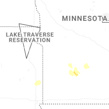
South Dakota
| Local Time | Report Details |
|---|---|
| 9:45 PM CDT | Personal weather statio in gregory county SD, 44.6 miles NNW of Oneill, NE |
| 10:08 PM CDT | Personal weather statio in charles mix county SD, 60.7 miles NNW of Oneill, NE |
| 10:29 PM CDT | Spotter reported that his son in town saw some trees blow down when the storm came throug in charles mix county SD, 54.8 miles N of Oneill, NE |
| 10:30 PM CDT | Lots of dust blew through his farmstead just north of geddes... and blew the barn door ope in charles mix county SD, 54.8 miles N of Oneill, NE |
| 10:36 PM CDT | Personal weather statio in charles mix county SD, 50.8 miles N of Oneill, NE |
| 11:52 PM CDT | Personal wether statio in bon homme county SD, 47.6 miles NE of Oneill, NE |
| 12:36 AM CDT | Personal weather statio in yankton county SD, 62.3 miles SW of Sioux Falls, SD |
| 1:02 AM CDT | Mesonet station 163 sd rwis freema in hutchinson county SD, 39.2 miles WSW of Sioux Falls, SD |
| 1:23 AM CDT | Mesonet station 310 sd rwis parker. initial gust to 61 mph... peak of 65 mph at 125 a in turner county SD, 21.3 miles SW of Sioux Falls, SD |
| 1:51 AM CDT | Storm damage reported in minnehaha county SD, 11.2 miles WNW of Sioux Falls, SD |
| 2:46 AM CDT | Awos station k4p3 2 s flandrea in moody county SD, 32.2 miles NNE of Sioux Falls, SD |
| 3:50 AM CDT | Mesonet station 291 4n altamont (sddot in deuel county SD, 47.4 miles W of Montevideo, MN |
| 4:17 AM CDT | Mesonet station 55 summit (sddot in roberts county SD, 69.7 miles WNW of Montevideo, MN |
| 4:27 AM CDT | Mesonet station 292 7ne milbank (sddot in grant county SD, 44.6 miles WNW of Montevideo, MN |
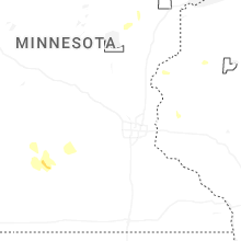
Minnesota
| Local Time | Report Details |
|---|---|
| 3:06 AM CDT | Mesonet station mn154 u.s.75 - trosky - mp 30. in pipestone county MN, 34.7 miles NE of Sioux Falls, SD |
| 3:17 AM CDT | Personal weather statio in pipestone county MN, 49.7 miles NNE of Sioux Falls, SD |
| 4:35 AM CDT | Mesonet station mn137 u.s.75 - ortonville - mp 132. in big stone county MN, 39.6 miles NW of Montevideo, MN |
| 4:45 AM CDT | Mesonet station mn036 t.h.28 - graceville - mp 1 in big stone county MN, 56.4 miles NW of Montevideo, MN |
Connect with Interactive Hail Maps