

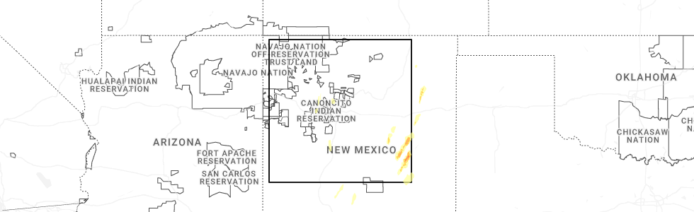
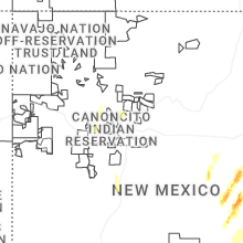
Hail Map for La Joya, NM
The La Joya, NM area has had 0 reports of on-the-ground hail by trained spotters, and has been under severe weather warnings 0 times during the past 12 months. Doppler radar has detected hail at or near La Joya, NM on 16 occasions, including 1 occasion during the past year.
| Name: | La Joya, NM |
| Where Located: | 52.3 miles SSW of Albuquerque, NM |
| Map: | Google Map for La Joya, NM |
| Population: | 82 |
| Housing Units: | 47 |
| More Info: | Search Google for La Joya, NM |
0
The Top Recent Hail Date for La Joya, NM is Saturday, October 19, 2024 (16th out of 16)
Hail and Wind Damage Spotted near La Joya, NM
| Date / Time | Report Details |
|---|---|
| 7/10/2021 8:57 PM MDT |
 The severe thunderstorm warning for northwestern socorro county will expire at 900 pm mdt, the storm which prompted the warning has weakened below severe limits, and no longer poses an immediate threat to life or property. therefore, the warning will be allowed to expire. however gusty winds and heavy rain are still possible with this thunderstorm. The severe thunderstorm warning for northwestern socorro county will expire at 900 pm mdt, the storm which prompted the warning has weakened below severe limits, and no longer poses an immediate threat to life or property. therefore, the warning will be allowed to expire. however gusty winds and heavy rain are still possible with this thunderstorm.
|
| 7/10/2021 8:43 PM MDT |
 At 843 pm mdt, a severe thunderstorm was located 8 miles northwest of lemitar, or 13 miles northwest of socorro, moving southeast at 25 mph (radar indicated). Hazards include 60 mph wind gusts. Expect damage to roofs, siding, and trees. locations impacted include, magdalena, lemitar, bernardo, la joya, san acacia, chamizal and contreras. this includes the following highways, interstate 25 between mile markers 154 and 177. Highway 60 between mile markers 109 and 120, and between mile markers 166 and 167. At 843 pm mdt, a severe thunderstorm was located 8 miles northwest of lemitar, or 13 miles northwest of socorro, moving southeast at 25 mph (radar indicated). Hazards include 60 mph wind gusts. Expect damage to roofs, siding, and trees. locations impacted include, magdalena, lemitar, bernardo, la joya, san acacia, chamizal and contreras. this includes the following highways, interstate 25 between mile markers 154 and 177. Highway 60 between mile markers 109 and 120, and between mile markers 166 and 167.
|
| 7/10/2021 8:17 PM MDT |
 At 816 pm mdt, a severe thunderstorm was located 14 miles north of magdalena, or 25 miles northwest of socorro, moving south at 30 mph (radar indicated). Hazards include 70 mph wind gusts and quarter size hail. Hail damage to vehicles is expected. expect considerable tree damage. wind damage is also likely to mobile homes, roofs, and outbuildings. locations impacted include, magdalena, lemitar, bernardo, la joya, san acacia, chamizal and contreras. this includes the following highways, interstate 25 between mile markers 154 and 178. Highway 60 between mile markers 106 and 107, between mile markers 109 and 120, and between mile markers 166 and 167. At 816 pm mdt, a severe thunderstorm was located 14 miles north of magdalena, or 25 miles northwest of socorro, moving south at 30 mph (radar indicated). Hazards include 70 mph wind gusts and quarter size hail. Hail damage to vehicles is expected. expect considerable tree damage. wind damage is also likely to mobile homes, roofs, and outbuildings. locations impacted include, magdalena, lemitar, bernardo, la joya, san acacia, chamizal and contreras. this includes the following highways, interstate 25 between mile markers 154 and 178. Highway 60 between mile markers 106 and 107, between mile markers 109 and 120, and between mile markers 166 and 167.
|
| 7/10/2021 7:56 PM MDT |
 At 755 pm mdt, a severe thunderstorm was located 23 miles north of magdalena, or 29 miles southwest of belen, moving south at 30 mph (radar indicated). Hazards include 70 mph wind gusts and quarter size hail. Hail damage to vehicles is expected. expect considerable tree damage. Wind damage is also likely to mobile homes, roofs, and outbuildings. At 755 pm mdt, a severe thunderstorm was located 23 miles north of magdalena, or 29 miles southwest of belen, moving south at 30 mph (radar indicated). Hazards include 70 mph wind gusts and quarter size hail. Hail damage to vehicles is expected. expect considerable tree damage. Wind damage is also likely to mobile homes, roofs, and outbuildings.
|
| 7/31/2020 7:17 PM MDT |
 At 716 pm mdt, a severe thunderstorm was located over rio communities, or near belen, moving south at 30 mph (radar indicated). Hazards include 60 mph wind gusts. Expect damage to roofs, siding, and trees. locations impacted include, southern albuquerque, valencia, los lunas, belen, bosque farms, peralta, mountainair, rio communities north, abo and jarales. this includes the following highways, interstate 40 between mile markers 122 and 141, and near mile marker 170. interstate 25 between mile markers 164 and 222. Highway 60 between mile markers 166 and 198, and between mile markers 201 and 206. At 716 pm mdt, a severe thunderstorm was located over rio communities, or near belen, moving south at 30 mph (radar indicated). Hazards include 60 mph wind gusts. Expect damage to roofs, siding, and trees. locations impacted include, southern albuquerque, valencia, los lunas, belen, bosque farms, peralta, mountainair, rio communities north, abo and jarales. this includes the following highways, interstate 40 between mile markers 122 and 141, and near mile marker 170. interstate 25 between mile markers 164 and 222. Highway 60 between mile markers 166 and 198, and between mile markers 201 and 206.
|
| 7/31/2020 6:43 PM MDT |
 At 642 pm mdt, a severe thunderstorm was located over bosque farms, or near los lunas, moving south at 45 mph. a 64 mph wind gust has already been reported at the albuquerque sunport (radar indicated). Hazards include 70 mph wind gusts. Expect considerable tree damage. Damage is likely to mobile homes, roofs, and outbuildings. At 642 pm mdt, a severe thunderstorm was located over bosque farms, or near los lunas, moving south at 45 mph. a 64 mph wind gust has already been reported at the albuquerque sunport (radar indicated). Hazards include 70 mph wind gusts. Expect considerable tree damage. Damage is likely to mobile homes, roofs, and outbuildings.
|
| 6/1/2019 1:58 PM MDT |
 At 158 pm mdt, a severe thunderstorm was located over la joya, or 20 miles south of belen, moving north at 35 mph (radar indicated). Hazards include 70 mph wind gusts and quarter size hail. Hail damage to vehicles is expected. expect considerable tree damage. wind damage is also likely to mobile homes, roofs, and outbuildings. locations impacted include, veguita, bernardo, la joya, las nutrias, sabinal, abeytas and contreras. This includes interstate 25 between mile markers 166 and 183. At 158 pm mdt, a severe thunderstorm was located over la joya, or 20 miles south of belen, moving north at 35 mph (radar indicated). Hazards include 70 mph wind gusts and quarter size hail. Hail damage to vehicles is expected. expect considerable tree damage. wind damage is also likely to mobile homes, roofs, and outbuildings. locations impacted include, veguita, bernardo, la joya, las nutrias, sabinal, abeytas and contreras. This includes interstate 25 between mile markers 166 and 183.
|
| 6/1/2019 1:41 PM MDT |
 At 141 pm mdt, a severe thunderstorm was located near san acacia, or 10 miles north of socorro, moving north at 30 mph (radar indicated). Hazards include 60 mph wind gusts and quarter size hail. Hail damage to vehicles is expected. Expect wind damage to roofs, siding, and trees. At 141 pm mdt, a severe thunderstorm was located near san acacia, or 10 miles north of socorro, moving north at 30 mph (radar indicated). Hazards include 60 mph wind gusts and quarter size hail. Hail damage to vehicles is expected. Expect wind damage to roofs, siding, and trees.
|
| 7/26/2018 8:38 PM MDT |
 At 837 pm mdt, a severe thunderstorm was located near la joya, or 20 miles southwest of belen, moving west at 5 mph (radar indicated). Hazards include 60 mph wind gusts and half dollar size hail. Hail damage to vehicles is expected. expect wind damage to roofs, siding, and trees. this severe thunderstorm will remain over mainly rural areas of north central socorro county. This includes interstate 25 between mile markers 167 and 173. At 837 pm mdt, a severe thunderstorm was located near la joya, or 20 miles southwest of belen, moving west at 5 mph (radar indicated). Hazards include 60 mph wind gusts and half dollar size hail. Hail damage to vehicles is expected. expect wind damage to roofs, siding, and trees. this severe thunderstorm will remain over mainly rural areas of north central socorro county. This includes interstate 25 between mile markers 167 and 173.
|
| 10/5/2017 2:28 PM MDT |
 At 228 pm mdt, a severe thunderstorm was located 11 miles northeast of magdalena, or 17 miles northwest of socorro, moving east at 25 mph (radar indicated). Hazards include 60 mph wind gusts and quarter size hail. Hail damage to vehicles is expected. Expect wind damage to roofs, siding, and trees. At 228 pm mdt, a severe thunderstorm was located 11 miles northeast of magdalena, or 17 miles northwest of socorro, moving east at 25 mph (radar indicated). Hazards include 60 mph wind gusts and quarter size hail. Hail damage to vehicles is expected. Expect wind damage to roofs, siding, and trees.
|
| 5/9/2017 5:20 PM MDT |
 At 520 pm mdt, a severe thunderstorm was located over la joya, or 17 miles north of socorro, moving north at 50 mph (radar indicated). Hazards include 60 mph wind gusts. expect damage to roofs, siding, and trees At 520 pm mdt, a severe thunderstorm was located over la joya, or 17 miles north of socorro, moving north at 50 mph (radar indicated). Hazards include 60 mph wind gusts. expect damage to roofs, siding, and trees
|
| 10/9/2016 2:32 PM MDT |
 At 232 pm mdt, a severe thunderstorm was located 8 miles west of san acacia, or 17 miles northwest of socorro, moving southeast at 35 mph (radar indicated). Hazards include 60 mph wind gusts and half dollar size hail. Hail damage to vehicles is expected. expect wind damage to roofs, siding, and trees. this severe thunderstorm will be near, san acacia and chamizal around 245 pm mdt. lemitar around 250 pm mdt. This includes interstate 25 between mile markers 141 and 169. At 232 pm mdt, a severe thunderstorm was located 8 miles west of san acacia, or 17 miles northwest of socorro, moving southeast at 35 mph (radar indicated). Hazards include 60 mph wind gusts and half dollar size hail. Hail damage to vehicles is expected. expect wind damage to roofs, siding, and trees. this severe thunderstorm will be near, san acacia and chamizal around 245 pm mdt. lemitar around 250 pm mdt. This includes interstate 25 between mile markers 141 and 169.
|
| 10/21/2015 7:12 AM MDT | The severe thunderstorm warning for north central socorro county will expire at 715 am mdt, the storm which prompted the warning has weakened below severe limits, and no longer pose an immediate threat to life or property. therefore the warning will be allowed to expire. |
| 10/21/2015 6:54 AM MDT |
 At 654 am mdt, a severe thunderstorm was located near san acacia, or 12 miles north of socorro, moving northeast at 30 mph (radar indicated). Hazards include 60 mph wind gusts and quarter size hail. Hail damage to vehicles is expected. expect wind damage to roofs, siding and trees. locations impacted include, socorro, san acacia, escondida, la joya, lemitar, bernardo, chamizal, contreras and abeytas. This includes interstate 25 between mile markers 151 and 180. At 654 am mdt, a severe thunderstorm was located near san acacia, or 12 miles north of socorro, moving northeast at 30 mph (radar indicated). Hazards include 60 mph wind gusts and quarter size hail. Hail damage to vehicles is expected. expect wind damage to roofs, siding and trees. locations impacted include, socorro, san acacia, escondida, la joya, lemitar, bernardo, chamizal, contreras and abeytas. This includes interstate 25 between mile markers 151 and 180.
|
| 10/21/2015 6:33 AM MDT |
 At 633 am mdt, a severe thunderstorm was located over escondida, or over socorro, moving northeast at 30 mph (radar indicated). Hazards include quarter size hail and 60 mph wind gusts. Hail damage to vehicles is expected. Expect wind damage to roofs, siding and trees. At 633 am mdt, a severe thunderstorm was located over escondida, or over socorro, moving northeast at 30 mph (radar indicated). Hazards include quarter size hail and 60 mph wind gusts. Hail damage to vehicles is expected. Expect wind damage to roofs, siding and trees.
|
| 10/19/2015 6:50 AM MDT |
 The severe thunderstorm warning for central socorro county will expire at 700 am mdt, the storm which prompted the warning has weakened below severe limits, and no longer pose an immediate threat to life or property. therefore the warning will be allowed to expire. The severe thunderstorm warning for central socorro county will expire at 700 am mdt, the storm which prompted the warning has weakened below severe limits, and no longer pose an immediate threat to life or property. therefore the warning will be allowed to expire.
|
| 10/19/2015 6:36 AM MDT |
 At 636 am mdt, a severe thunderstorm was located over escondida, or near socorro, moving east at 30 mph (radar indicated). Hazards include 60 mph wind gusts and penny size hail. Expect damage to roofs. siding and trees. locations impacted include, socorro, lemitar, san acacia, escondida and chamizal. This includes interstate 25 between mile markers 146 and 167. At 636 am mdt, a severe thunderstorm was located over escondida, or near socorro, moving east at 30 mph (radar indicated). Hazards include 60 mph wind gusts and penny size hail. Expect damage to roofs. siding and trees. locations impacted include, socorro, lemitar, san acacia, escondida and chamizal. This includes interstate 25 between mile markers 146 and 167.
|
| 10/19/2015 6:25 AM MDT |
 At 625 am mdt, a severe thunderstorm was located 6 miles west of escondida, or 7 miles northwest of socorro, moving northeast at 30 mph (radar indicated). Hazards include quarter size hail and 60 mph wind gusts. Hail damage to vehicles is expected. Expect wind damage to roofs, siding and trees. At 625 am mdt, a severe thunderstorm was located 6 miles west of escondida, or 7 miles northwest of socorro, moving northeast at 30 mph (radar indicated). Hazards include quarter size hail and 60 mph wind gusts. Hail damage to vehicles is expected. Expect wind damage to roofs, siding and trees.
|
Hail Maps for La Joya, NM


Connect with Interactive Hail Maps