

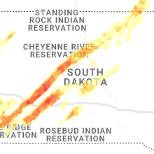
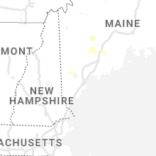
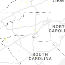
Hail Map for Monday, June 13, 2022

Number of Impacted Households on 6/13/2022
0
Impacted by 1" or Larger Hail
0
Impacted by 1.75" or Larger Hail
0
Impacted by 2.5" or Larger Hail
Square Miles of Populated Area Impacted on 6/13/2022
0
Impacted by 1" or Larger Hail
0
Impacted by 1.75" or Larger Hail
0
Impacted by 2.5" or Larger Hail


Cities Most Affected by Hail Storms of 6/13/2022
| Hail Size | Demographics of Zip Codes Affected | ||||||
|---|---|---|---|---|---|---|---|
| City | Count | Average | Largest | Pop Density | House Value | Income | Age |
| Hot Springs, SD | 8 | 2.38 | 4.00 | 11 | $63k | $30.3k | 50.7 |
| Kadoka, SD | 2 | 2.50 | 2.50 | 0 | $32k | $25.4k | 45.3 |
| Wall, SD | 2 | 2.25 | 2.75 | 1 | $63k | $36.2k | 43.8 |
| Manville, WY | 2 | 2.13 | 2.50 | 0 | $48k | $20.9k | 55.1 |
| Dousman, WI | 2 | 1.88 | 2.00 | 191 | $191k | $58.8k | 45.5 |
| Lusk, WY | 2 | 1.88 | 2.00 | 0 | $63k | $30.4k | 44.7 |
| Wanblee, SD | 1 | 3.25 | 3.25 | 1 | $62k | $13.8k | 22.5 |
| Forbes, ND | 1 | 3.00 | 3.00 | 1 | $106k | $22.2k | 36.2 |
| Quinn, SD | 1 | 2.50 | 2.50 | 1 | $33k | $30.6k | 44.5 |
| Sun Prairie, WI | 1 | 2.00 | 2.00 | 557 | $149k | $55.5k | 34.6 |
| Helenville, WI | 1 | 1.75 | 1.75 | 50 | $131k | $52.0k | 43.1 |
| Oconomowoc, WI | 1 | 1.75 | 1.75 | 330 | $173k | $61.0k | 41.5 |
| Mukwonago, WI | 1 | 1.75 | 1.75 | 334 | $167k | $64.9k | 41.1 |
| Jefferson, WI | 1 | 1.75 | 1.75 | 147 | $117k | $43.7k | 39.2 |
| Frederick, SD | 1 | 1.75 | 1.75 | 1 | $40k | $32.5k | 44.1 |
| Fort Wayne, IN | 1 | 1.75 | 1.75 | 296 | $108k | $44.8k | 35.3 |
| North Prairie, WI | 1 | 1.75 | 1.75 | 585 | $160k | $68.2k | 41.7 |
| Philip, SD | 1 | 1.75 | 1.75 | 0 | $52k | $31.7k | 49.7 |
| Leola, SD | 1 | 1.75 | 1.75 | 1 | $20k | $23.8k | 42.5 |
| Johnson Creek, WI | 1 | 1.75 | 1.75 | 127 | $129k | $47.1k | 35.4 |
| Britt, IA | 1 | 1.75 | 1.75 | 20 | $60k | $34.9k | 45.0 |
Hail and Wind Damage Spotted on 6/13/2022
Filter by Report Type:Hail ReportsWind Reports
States Impacted
Minnesota, Iowa, West Virginia, Virginia, Indiana, Wisconsin, Maine, Ohio, Kentucky, North Carolina, South Carolina, Illinois, Maryland, Utah, Michigan, Wyoming, North Dakota, Georgia, South DakotaMinnesota
| Local Time | Report Details |
|---|---|
| 7:35 AM CDT | Quarter sized hail reported near Mapleton, MN, 62.8 miles NW of Mason City, IA, mostly smaller hail... with some stones at least quarter size. |
| 9:08 AM CDT | Quarter sized hail reported near Fulda, MN, 69.9 miles ENE of Sioux Falls, SD |
| 9:15 AM CDT | Awos station kmwm windom municipal airpor in cottonwood county MN, 78.8 miles SSE of Montevideo, MN |
| 9:20 AM CDT | Quarter sized hail reported near Owatonna, MN, 62.1 miles S of Minneapolis, MN |
| 9:21 AM CDT | Half Dollar sized hail reported near Owatonna, MN, 62.8 miles S of Minneapolis, MN |
Iowa
| Local Time | Report Details |
|---|---|
| 8:15 AM CDT | Quarter sized hail reported near Kanawha, IA, 33.1 miles WSW of Mason City, IA |
| 8:24 AM CDT | Golf Ball sized hail reported near Britt, IA, 26.6 miles W of Mason City, IA, hail image submitted via twitter. size and location both estimated. |
| 8:33 AM CDT | Quarter sized hail reported near Garner, IA, 20.4 miles W of Mason City, IA, image submitted via twitter. size estimated based on photo. |
| 8:36 AM CDT | Half Dollar sized hail reported near Garner, IA, 20.4 miles W of Mason City, IA, time estimated from radar. |
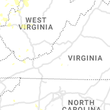
West Virginia
| Local Time | Report Details |
|---|---|
| 9:15 AM EDT | Tree dow in boone county WV, 29.8 miles S of Charleston, WV |
| 8:25 PM EDT | Tree dow in cabell county WV, 39.2 miles W of Charleston, WV |
| 8:25 PM EDT | Multiple trees down along morris stree in mason county WV, 43.5 miles NW of Charleston, WV |
| 8:35 PM EDT | Tree reported down on i-64 westbound by wv 511. time estimated from rada in cabell county WV, 29.5 miles WNW of Charleston, WV |
| 8:38 PM EDT | Trees uprooted or snapped; roof blown of in wayne county WV, 38.7 miles W of Charleston, WV |
| 8:40 PM EDT | Trees dow in mason county WV, 32.6 miles NNW of Charleston, WV |
| 8:42 PM EDT | Large tree down on ashton street. time estimated from rada in jackson county WV, 41.8 miles N of Charleston, WV |
| 8:42 PM EDT | Multiple trees dow in putnam county WV, 25.7 miles NW of Charleston, WV |
| 8:45 PM EDT | Corrects previous tstm wnd dmg report from 5 ene leon. trees uprooted or snapped. time estimated from rada in mason county WV, 32.8 miles NNW of Charleston, WV |
| 8:45 PM EDT | Tree down in roa in putnam county WV, 21.1 miles WNW of Charleston, WV |
| 8:53 PM EDT | Large limbs down. power ou in lincoln county WV, 18.2 miles WSW of Charleston, WV |
| 8:53 PM EDT | Trained spotter reports tree down on state route 68. time estimated from rada in wood county WV, 57.9 miles N of Charleston, WV |
| 8:55 PM EDT | Tree blocking buck run road... reported via social media. time estimated from rada in wood county WV, 52.5 miles N of Charleston, WV |
| 9:00 PM EDT | Tree dow in kanawha county WV, 0.1 miles WSW of Charleston, WV |
| 9:00 PM EDT | Corrects previous tstm wnd dmg report from 1 ssw cross lanes. tree dow in kanawha county WV, 9 miles WNW of Charleston, WV |
| 9:00 PM EDT | Corrects previous tstm wnd dmg report from 1 ssw cross lanes. tree dow in kanawha county WV, 9 miles WNW of Charleston, WV |
| 9:00 PM EDT | Tree dow in kanawha county WV, 9.1 miles WSW of Charleston, WV |
| 9:00 PM EDT | Tree down in roa in kanawha county WV, 0.8 miles NE of Charleston, WV |
| 9:05 PM EDT | Trees and powerlines dow in wirt county WV, 50.6 miles NNE of Charleston, WV |
| 9:06 PM EDT | Quarter sized hail reported near Salt Rock, WV, 32.7 miles W of Charleston, WV |
| 9:10 PM EDT | Tree reported down on i-77 at mile marker 98 via wv 511. time estimated by rada in kanawha county WV, 2.5 miles ESE of Charleston, WV |
| 9:11 PM EDT | Spotter reports tree down on atkinson ridge road... with many power outages. time estimated from rada in wood county WV, 57.2 miles NNE of Charleston, WV |
| 9:11 PM EDT | Trees dow in wood county WV, 63 miles N of Charleston, WV |
| 9:12 PM EDT | Tree dow in kanawha county WV, 3.9 miles W of Charleston, WV |
| 9:14 PM EDT | Report from mping: trees uprooted or snappe in kanawha county WV, 4.2 miles SE of Charleston, WV |
| 9:15 PM EDT | Tree dow in boone county WV, 18.2 miles SW of Charleston, WV |
| 9:15 PM EDT | Tree dow in boone county WV, 28.4 miles SSW of Charleston, WV |
| 9:15 PM EDT | Tree dow in kanawha county WV, 17.9 miles SE of Charleston, WV |
| 9:15 PM EDT | Couple of trees down around alum creek. time is a radar estimat in lincoln county WV, 11.3 miles WSW of Charleston, WV |
| 9:15 PM EDT | Corrects previous tstm wnd dmg report from 9 wsw whitesville. tree dow in boone county WV, 29.8 miles S of Charleston, WV |
| 9:15 PM EDT | Tree dow in boone county WV, 26.1 miles SSE of Charleston, WV |
| 9:20 PM EDT | Tree dow in clay county WV, 35 miles ENE of Charleston, WV |
| 9:20 PM EDT | 2 trees dow in clay county WV, 31.2 miles ENE of Charleston, WV |
| 9:20 PM EDT | Tree dow in fayette county WV, 20.5 miles SE of Charleston, WV |
| 9:20 PM EDT | Tree dow in kanawha county WV, 18.4 miles ENE of Charleston, WV |
| 9:23 PM EDT | Tree dow in logan county WV, 34.5 miles SW of Charleston, WV |
| 9:25 PM EDT | Tree dow in logan county WV, 44.4 miles SSW of Charleston, WV |
| 9:25 PM EDT | Tree dow in wyoming county WV, 56.6 miles S of Charleston, WV |
| 9:26 PM EDT | Multiple trees dow in putnam county WV, 17.2 miles WNW of Charleston, WV |
| 9:27 PM EDT | Multiple trees dow in putnam county WV, 21.6 miles WNW of Charleston, WV |
| 9:28 PM EDT | Multiple trees dow in putnam county WV, 25.7 miles NW of Charleston, WV |
| 9:30 PM EDT | Tree down. time is radar estimate in fayette county WV, 37.4 miles SE of Charleston, WV |
| 9:30 PM EDT | Tree down at center street/pratt av in kanawha county WV, 16.6 miles SE of Charleston, WV |
| 9:32 PM EDT | Tree dow in fayette county WV, 35.9 miles SE of Charleston, WV |
| 9:35 PM EDT | Few trees down. time is radar estimate in raleigh county WV, 47.5 miles SSE of Charleston, WV |
| 9:35 PM EDT | Tree dow in fayette county WV, 53.2 miles ESE of Charleston, WV |
| 9:51 PM EDT | Clay county cert reports two trees and power lines down on route 36 wallback roa in clay county WV, 29.7 miles ENE of Charleston, WV |
| 9:55 PM EDT | Trees dow in wood county WV, 63 miles N of Charleston, WV |
| 9:56 PM EDT | Trees and powerlines dow in wirt county WV, 50.6 miles NNE of Charleston, WV |
| 10:15 PM EDT | Couple of trees down around alum creek. time is a radar estimat in lincoln county WV, 11.3 miles WSW of Charleston, WV |
| 10:18 PM EDT | Several trees dow in raleigh county WV, 49.8 miles SSE of Charleston, WV |
| 10:21 PM EDT | Trees dow in wayne county WV, 49.5 miles W of Charleston, WV |
| 10:23 PM EDT | Tree dow in logan county WV, 44.4 miles SSW of Charleston, WV |
| 10:23 PM EDT | Tree dow in logan county WV, 34.5 miles SW of Charleston, WV |
| 10:25 PM EDT | Trees dow in wayne county WV, 47.5 miles WSW of Charleston, WV |
| 10:25 PM EDT | Tree dow in wyoming county WV, 56.6 miles S of Charleston, WV |
| 10:27 PM EDT | Multiple trees down on walkers branch r in wayne county WV, 49.6 miles W of Charleston, WV |
| 10:45 PM EDT | Multiple trees were blown down by thunderstorm winds along a stretch of friars hill roa in greenbrier county WV, 58.4 miles NNW of Roanoke, VA |
| 10:45 PM EDT | Tree down on route 20 south of rainell in greenbrier county WV, 54 miles ESE of Charleston, WV |
| 10:45 PM EDT | Report from mping: trees uprooted or snapped. time estimated from rada in mason county WV, 32.8 miles NNW of Charleston, WV |
| 10:50 PM EDT | A powerline was blown down by thunderstorm winds along coal heritage roa in mercer county WV, 72 miles SSE of Charleston, WV |
| 1:11 AM EDT | Most rural roads around the wheeling area are impassable due to trees and power lines dow in ohio county WV, 44.6 miles WSW of Pittsburgh, PA |
| 1:11 AM EDT | Most rural roads around the wheeling area are impassable due to trees and power lines dow in ohio county WV, 44.6 miles WSW of Pittsburgh, PA |
| 1:15 AM EDT | Damage to roof and structure... and numerous downed tree in ohio county WV, 38.3 miles SW of Pittsburgh, PA |
| 1:16 AM EDT | Multiple trees and untility poles down in ohio county WV, 44.6 miles WSW of Pittsburgh, PA |
| 1:17 AM EDT | Report of multiple downed trees on west alexander road... utility trailers pushed up against each other... and roof damag in ohio county WV, 38.6 miles SW of Pittsburgh, PA |
| 2:01 AM EDT | 3-inch tree limbs broken; power poles broke in mason county WV, 44.3 miles NW of Charleston, WV |
Virginia
| Local Time | Report Details |
|---|---|
| 11:55 AM EDT | A large tree limb was blown down by thunderstorm winds across kirby road... partially blocking the roadwa in pulaski county VA, 48.7 miles WSW of Roanoke, VA |
| 6:40 PM EDT | Two trees blew down in the 3000 block of va-729 buck island roa in albemarle county VA, 52.2 miles NW of Richmond, VA |
| 6:58 PM EDT | Tree down on cartners mountain road near grand cru driv in albemarle county VA, 55.3 miles NW of Richmond, VA |
| 7:00 PM EDT | Tree down near the intersection of route 611 and chartwell lan in loudoun county VA, 59 miles W of Baltimore, MD |
| 7:27 PM EDT | A few trees and wires blew down in the reston/herndon are in fairfax county VA, 43.8 miles WSW of Baltimore, MD |
| 11:05 PM EDT | A tree was blown down by thunderstorm winds along the 7300 block of the n scenic highwa in bland county VA, 65.8 miles W of Roanoke, VA |
| 11:45 PM EDT | A tree was blown down by thunderstorm winds along black hollow roa in pulaski county VA, 44.3 miles WSW of Roanoke, VA |
| 11:45 PM EDT | A tree was blown down by thunderstorm winds along clover hollow roa in giles county VA, 30.9 miles W of Roanoke, VA |
| 11:46 PM EDT | A tree was blown down along dora highway by thunderstorm wind in pulaski county VA, 48.5 miles WSW of Roanoke, VA |
| 11:50 PM EDT | A tree was blown down by thunderstorm winds near the intersection of ceres school road and the blue grass trai in bland county VA, 57.1 miles ENE of Bristol, TN |
| 11:55 PM EDT | A tree was blown down by thunderstorm winds along baker roa in pulaski county VA, 42.9 miles WSW of Roanoke, VA |
| 12:00 AM EDT | A large tree was uprooted on gold drive in christiansburg. time estimated by rada in montgomery county VA, 26.6 miles WSW of Roanoke, VA |
| 12:20 AM EDT | Tree down across bethlehem church road. time estimated by rada in floyd county VA, 26.9 miles SW of Roanoke, VA |
| 12:55 AM EDT | Tree down along morning side driv in henry county VA, 39.4 miles S of Roanoke, VA |
| 4:27 AM EDT | Multiple trees dow in tazewell county VA, 53.3 miles NE of Bristol, TN |
| 4:40 AM EDT | Multiple trees dow in tazewell county VA, 42.8 miles NE of Bristol, TN |
| 4:41 AM EDT | Multiple trees down in tannersvill in tazewell county VA, 41.9 miles NE of Bristol, TN |
| 4:55 AM EDT | Trees down along spring valley rd. as well as other portions of the county through 515 a in smyth county VA, 40.3 miles ENE of Bristol, TN |
Indiana
| Local Time | Report Details |
|---|---|
| 3:33 PM EDT | Quarter sized hail reported near Michigantown, IN, 42.9 miles NNW of Indianapolis, IN, along sr29 north of michigantown. time estimated from radar. |
| 3:57 PM EDT | Several tree limbs of unknown size downed in russiaville. time estimated from rada in howard county IN, 45.5 miles N of Indianapolis, IN |
| 4:10 PM EDT | Quarter sized hail reported near Carthage, IN, 26.8 miles E of Indianapolis, IN, time estimated from radar. relayed via social media. |
| 4:48 PM EDT | Tree down across the roadway at 2592 e 1100 n in roanoke. time estimated from rada in huntington county IN, 16.4 miles WSW of Fort Wayne, IN |
| 5:00 PM EDT | Trees and power lines downe in rush county IN, 41.2 miles E of Indianapolis, IN |
| 5:08 PM EDT | Trees and ppwer lines down. time is estimated from rada in rush county IN, 45 miles ESE of Indianapolis, IN |
| 5:12 PM EDT | Storm damage reported in wayne county IN, 48.5 miles NNW of Cincinnati, OH |
| 5:26 PM EDT | Large limb down. power lines down. time estimated from rada in ripley county IN, 41.2 miles WNW of Cincinnati, OH |
| 5:27 PM EDT | Power pole down. time estimated from rada in ripley county IN, 40.6 miles WNW of Cincinnati, OH |
| 5:31 PM EDT | Trees and power lines down. time estimated from rada in ripley county IN, 35.9 miles WNW of Cincinnati, OH |
| 5:40 PM EDT | Trees dow in ripley county IN, 36.3 miles W of Cincinnati, OH |
| 7:25 PM CDT | Large tree downed across the road near the center of tow in la porte county IN, 49.6 miles SE of Chicago, IL |
| 7:38 PM CDT | Storm damage reported in lake county IN, 21.3 miles SSE of Chicago, IL |
| 7:39 PM CDT | Storm damage reported in lake county IN, 18.4 miles SE of Chicago, IL |
| 7:53 PM CDT | Report of a tree down on a house... relayed by em officia in porter county IN, 30.1 miles SE of Chicago, IL |
| 8:55 PM EDT | Reports of roof collapse and partial remova in steuben county IN, 43.1 miles N of Fort Wayne, IN |
| 7:56 PM CDT | Quarter sized hail reported near Gary, IN, 26.9 miles SE of Chicago, IL |
| 7:56 PM CDT | Ping Pong Ball sized hail reported near Gary, IN, 29.3 miles SSE of Chicago, IL |
| 9:05 PM EDT | Quarter sized hail reported near Elkhart, IN, 60.4 miles NW of Fort Wayne, IN, social media report of quarter sized hail (about 1 inch) in elkhart in elkhart county indiana. |
| 9:10 PM EDT | Two 30 inch diameter trees broken at base of trun in steuben county IN, 35.1 miles N of Fort Wayne, IN |
| 9:15 PM EDT | Quarter sized hail reported near Elkhart, IN, 62.6 miles NW of Fort Wayne, IN, report from mping: quarter (1.00 in.). |
| 9:16 PM EDT | Report from mping: 3-inch tree limbs broken; power poles broke in steuben county IN, 38.6 miles N of Fort Wayne, IN |
| 9:19 PM EDT | Multiple trees downed along cr-28. time estimated by rada in elkhart county IN, 58.4 miles NW of Fort Wayne, IN |
| 9:20 PM EDT | Report from mping: 3-inch tree limbs broken; power poles broke in steuben county IN, 38.6 miles N of Fort Wayne, IN |
| 8:25 PM CDT | Corrects previous tstm wnd dmg report from wanatah. large tree downed across the road near the center of tow in la porte county IN, 49.6 miles SE of Chicago, IL |
| 9:30 PM EDT | Nws employee reported a large tree snapped 20 feet up and fell onto a house with possible damage to a vehicle in goshen in elkhart county indiana . no injuries. pea siz in elkhart county IN, 50.7 miles NW of Fort Wayne, IN |
| 9:38 PM EDT | Trees reported down on morrison island on east side of lake wawase in kosciusko county IN, 36.8 miles NW of Fort Wayne, IN |
| 9:40 PM EDT | 6 to 8 inch tree limb dow in kosciusko county IN, 39.4 miles WNW of Fort Wayne, IN |
| 9:40 PM EDT | Large tree down across t34c lane. power lines dow in kosciusko county IN, 39.9 miles WNW of Fort Wayne, IN |
| 9:40 PM EDT | Picture of large tree down on hatchery road on south side of lake wawase in kosciusko county IN, 36.8 miles NW of Fort Wayne, IN |
| 9:40 PM EDT | Wind gusts estimated to at least 60 mp in kosciusko county IN, 37 miles WNW of Fort Wayne, IN |
| 9:45 PM EDT | Numerous tree limbs down along sr 13 in and south of n webste in kosciusko county IN, 35.9 miles WNW of Fort Wayne, IN |
| 9:46 PM EDT | 1 ft diameter healthy limb down at the ligonier public librar in noble county IN, 36.8 miles NW of Fort Wayne, IN |
| 9:50 PM EDT | Public report of thunderstorm wind damage of 2 large (80 to 85 foot) trees downed near north webster in kosciusko county in indiana. one tree was completely across east in kosciusko county IN, 35.1 miles WNW of Fort Wayne, IN |
| 9:50 PM EDT | Corrects previous tstm wnd dmg report from 1 nne sechrist lake. large tree uprooted and fell into a house near 500 n and 700 in kosciusko county IN, 35.7 miles WNW of Fort Wayne, IN |
| 9:50 PM EDT | Corrects previous tstm wnd dmg report from 1 nne sechrist lake. large tree uprooted and fell into a house near 500 n and 700 in kosciusko county IN, 35.7 miles WNW of Fort Wayne, IN |
| 9:55 PM EDT | Enchanted hills subdivision between syracuse and cromwell... in. 18 inch diameter tree branch down across and into a mobile home. next house to the east has a 12 inch d in kosciusko county IN, 37.2 miles NW of Fort Wayne, IN |
| 9:57 PM EDT | Report from mping: trees uprooted or snapped; roof blown of in allen county IN, 3.5 miles NE of Fort Wayne, IN |
| 10:00 PM EDT | Tree down into house. person trapped in hous in whitley county IN, 22.3 miles WNW of Fort Wayne, IN |
| 10:00 PM EDT | Tree onto car. person trapped in car. lines also down. sr 109 and cr 400 in whitley county IN, 21.3 miles WNW of Fort Wayne, IN |
| 10:05 PM EDT | Off duty nws employee reported siding in his yar in whitley county IN, 17.8 miles WNW of Fort Wayne, IN |
| 10:12 PM EDT | Tree through house... between us 30 and washington center... near the allen/ whitley county lin in allen county IN, 12.6 miles WNW of Fort Wayne, IN |
| 10:15 PM EDT | Social media report of large estimated 24 inch diameter tree limb snapped off near rolling hills in allen county indian in allen county IN, 9 miles WSW of Fort Wayne, IN |
| 10:20 PM EDT | 2 large trees down in roanoke. also several smaller tree limbs down... including one onto sheriff deputy vehicle with minor damag in huntington county IN, 15.9 miles WSW of Fort Wayne, IN |
| 10:23 PM EDT | Multiple trees dow in allen county IN, 14.4 miles NW of Fort Wayne, IN |
| 10:25 PM EDT | 2 foot tree onto house. person trapped in the bella vista neighborhoo in allen county IN, 4.9 miles SW of Fort Wayne, IN |
| 10:25 PM EDT | Multiple trees down at covington and county line roa in whitley county IN, 12.6 miles W of Fort Wayne, IN |
| 10:26 PM EDT | Golf Ball sized hail reported near Fort Wayne, IN, 10.8 miles NNW of Fort Wayne, IN |
| 10:28 PM EDT | Multiple power poles down in road. aboite center rd near homestead h in allen county IN, 9.8 miles WSW of Fort Wayne, IN |
| 10:28 PM EDT | Specific location unknown... but 2 trees onto cars on 700 n from em in whitley county IN, 28.9 miles WNW of Fort Wayne, IN |
| 10:29 PM EDT | Multiple trees down. dupont and coldwate in allen county IN, 7.4 miles NNW of Fort Wayne, IN |
| 10:30 PM EDT | Public reported that the local fire department had evacuated 10 structures (homes) due to wind damage in arcola in allen county indian in allen county IN, 10.1 miles W of Fort Wayne, IN |
| 10:30 PM EDT | Mesonet station pdu05 northeast purdue agricultural c in whitley county IN, 15.9 miles W of Fort Wayne, IN |
| 10:33 PM EDT | Uprooted 36 inch diameter mature oak tree into she in whitley county IN, 22.7 miles NW of Fort Wayne, IN |
| 10:35 PM EDT | Trained spotter reported estimated wind gusts around 80 mph and large trees broken in southwest fort wayne in allen county indiana. power was also lost at the locatio in allen county IN, 3.6 miles WSW of Fort Wayne, IN |
| 10:39 PM EDT | 2 ft diameter tree snapped in half. healthy tre in allen county IN, 9.3 miles WSW of Fort Wayne, IN |
| 10:39 PM EDT | Asos station kfwa fort wayne international a in allen county IN, 7.8 miles SSW of Fort Wayne, IN |
| 10:39 PM EDT | Multiple trees down on multiple houses... 2700 block of fairbrook cour in allen county IN, 4.9 miles SW of Fort Wayne, IN |
| 10:39 PM EDT | Significant structural damage to the skywest airlines building at fort wayne int. ap. 98 mph wind gust reported at the airpor in allen county IN, 8.7 miles SSW of Fort Wayne, IN |
| 10:40 PM EDT | Healthy 2 foot diameter oak tree snapped off about 20 feet above the groun in allen county IN, 7.9 miles SSW of Fort Wayne, IN |
| 10:40 PM EDT | Trained spotter reports measured 76 mph gusts near yoder in allen county indian in allen county IN, 10.9 miles SSW of Fort Wayne, IN |
| 10:45 PM EDT | Asos station kfwa fort wayne international a in allen county IN, 7.8 miles SSW of Fort Wayne, IN |
| 10:48 PM EDT | Quarter sized hail reported near Fort Wayne, IN, 6.2 miles SSE of Fort Wayne, IN, report from mping: quarter (1.00 in.). |
| 10:51 PM EDT | Multiple trees down. also electrical fire from power pol in adams county IN, 18.9 miles SSE of Fort Wayne, IN |
Wisconsin
| Local Time | Report Details |
|---|---|
| 2:47 PM CDT | Quarter sized hail reported near Cross Plains, WI, 13.6 miles WNW of Madison, WI, report from mping: quarter (1.00 in.). |
| 2:50 PM CDT | Numerous reports of trees and wires down along with blown transformers across the western portion of madison and middleto in dane county WI, 6.7 miles W of Madison, WI |
| 2:53 PM CDT | Roof damage to an apartment complex on wright street. time est by rada in dane county WI, 4.3 miles NE of Madison, WI |
| 2:55 PM CDT | Numerous trees and powerlines down. debris flying past windows on 8th story of office buildin in dane county WI, 1 miles ENE of Madison, WI |
| 2:57 PM CDT | Numerous trees and power poles down near the monona golf course. large limbs snapped off tree in dane county WI, 3.4 miles E of Madison, WI |
| 3:00 PM CDT | Half Dollar sized hail reported near Madison, WI, 1.5 miles NE of Madison, WI, report from mping: half dollar (1.25 in.). |
| 3:02 PM CDT | Quarter sized hail reported near Madison, WI, 3.8 miles NE of Madison, WI |
| 3:05 PM CDT | Half Dollar sized hail reported near Sun Prairie, WI, 11.7 miles NE of Madison, WI, mping report. |
| 3:08 PM CDT | Half Dollar sized hail reported near Cottage Grove, WI, 10.5 miles E of Madison, WI, mping. |
| 3:08 PM CDT | Ping Pong Ball sized hail reported near Sun Prairie, WI, 12 miles NE of Madison, WI, report from mping: ping pong ball (1.50 in.). |
| 3:08 PM CDT | Hen Egg sized hail reported near Sun Prairie, WI, 11.6 miles NE of Madison, WI, estimated 2.25 inch from social media image. |
| 3:10 PM CDT | Ping Pong Ball sized hail reported near Deerfield, WI, 12.5 miles E of Madison, WI, report from mping: ping pong ball (1.50 in.). |
| 3:10 PM CDT | Ping Pong Ball sized hail reported near Deerfield, WI, 16.1 miles E of Madison, WI, size est from social media pic. |
| 3:15 PM CDT | Ping Pong Ball sized hail reported near Deerfield, WI, 15.6 miles E of Madison, WI, picture on social media. |
| 3:25 PM CDT | Widespread tree damage across lake mills. time est from rada in jefferson county WI, 24.1 miles E of Madison, WI |
| 3:34 PM CDT | Golf Ball sized hail reported near Jefferson, WI, 29.8 miles E of Madison, WI, report from mping: golf ball (1.75 in.). |
| 3:35 PM CDT | Golf Ball sized hail reported near Johnson Creek, WI, 30.7 miles E of Madison, WI, 50-60 mph gusts. |
| 3:42 PM CDT | Half Dollar sized hail reported near Watertown, WI, 33 miles ENE of Madison, WI |
| 3:44 PM CDT | Golf Ball sized hail reported near Helenville, WI, 35.5 miles E of Madison, WI, 1 e of helenville. |
| 3:47 PM CDT | Half Dollar sized hail reported near Ixonia, WI, 40.1 miles E of Madison, WI, size est from social media pic. time est from radar. |
| 3:55 PM CDT | Half Dollar sized hail reported near Oconomowoc, WI, 42.9 miles E of Madison, WI, certified weather observer. |
| 3:55 PM CDT | Golf Ball sized hail reported near Dousman, WI, 43 miles E of Madison, WI, at wfo mkx. |
| 3:55 PM CDT | Hen Egg sized hail reported near Dousman, WI, 43 miles E of Madison, WI, largest stone was 2 inches...measured. corrects previous hail report from 4 sse sullivan. at wfo mkx. |
| 3:55 PM CDT | Large tree snapped near base. time est from rada in dane county WI, 4 miles SSW of Madison, WI |
| 3:56 PM CDT | Golf Ball sized hail reported near Oconomowoc, WI, 43.4 miles E of Madison, WI, report from mping: golf ball (1.75 in.). |
| 4:00 PM CDT | Widespread reports of trees and wires down across much of western waukesha count in waukesha county WI, 47.9 miles E of Madison, WI |
| 4:00 PM CDT | Quarter sized hail reported near Oconomowoc, WI, 47.9 miles E of Madison, WI |
| 4:02 PM CDT | Golf Ball sized hail reported near North Prairie, WI, 50.8 miles E of Madison, WI, time est from radar. |
| 4:03 PM CDT | Quarter sized hail reported near Wales, WI, 51.2 miles E of Madison, WI, from social media pic. time est from radar. |
| 4:03 PM CDT | Half Dollar sized hail reported near Wales, WI, 51.2 miles E of Madison, WI, size est from social media pic. time est from radar. |
| 4:12 PM CDT | Golf Ball sized hail reported near Mukwonago, WI, 58.8 miles ESE of Madison, WI, report is from vernon. |
| 4:15 PM CDT | Storm damage reported in waukesha county WI, 64.4 miles E of Madison, WI |
| 4:16 PM CDT | Quarter sized hail reported near Waukesha, WI, 59.9 miles E of Madison, WI |
| 4:20 PM CDT | Tree damage. time est by rada in milwaukee county WI, 68.3 miles E of Madison, WI |
| 4:26 PM CDT | Half Dollar sized hail reported near Greendale, WI, 71.4 miles E of Madison, WI, size est from social media pic. |
| 4:30 PM CDT | Numerous trees and branches down. time est from rada in milwaukee county WI, 72.4 miles N of Chicago, IL |
| 4:30 PM CDT | Half Dollar sized hail reported near Franklin, WI, 70.9 miles E of Madison, WI |
| 4:39 PM CDT | At mke. also had half inch hai in milwaukee county WI, 74.8 miles N of Chicago, IL |
Maine
| Local Time | Report Details |
|---|---|
| 5:12 PM EDT | Trees down on electricity wires on notch road-relayed by trained spotter/somerset county dispatc in somerset county ME, 39.8 miles W of Bangor, ME |
| 5:19 PM EDT | Quarter sized hail reported near Readfield, ME, 54.2 miles NNE of Portland, ME, via mping. |
Ohio
| Local Time | Report Details |
|---|---|
| 5:28 PM EDT | Quarter sized hail reported near Hamilton, OH, 23.1 miles N of Cincinnati, OH, quarter sized/ 1 inch hail |
| 5:30 PM EDT | 1/4 mile swath of 1 inch limbs down. time from radar in preble county OH, 45.7 miles N of Cincinnati, OH |
| 5:30 PM EDT | Large tree down on eaton gettysburg road. time estimated from rada in preble county OH, 46.4 miles N of Cincinnati, OH |
| 5:41 PM EDT | From personal weather station at preble county ema office in preble county OH, 51 miles N of Cincinnati, OH |
| 5:45 PM EDT | Mesonet station ew6002 hamilto in butler county OH, 20.9 miles N of Cincinnati, OH |
| 5:45 PM EDT | 6-12 inch branches dow in butler county OH, 25.9 miles N of Cincinnati, OH |
| 5:47 PM EDT | Large tree blocking cincinnati-dayton road. time estimated from rada in butler county OH, 18.4 miles NNE of Cincinnati, OH |
| 5:48 PM EDT | Limb 2+ foot in diameter dow in butler county OH, 17 miles N of Cincinnati, OH |
| 5:50 PM EDT | Branches down on cars and on banning roa in hamilton county OH, 8.2 miles NNW of Cincinnati, OH |
| 5:50 PM EDT | Trees down all along 9th stree in lawrence county OH, 57.8 miles WNW of Charleston, WV |
| 5:53 PM EDT | Large tree limb down. time from radar in butler county OH, 20.4 miles N of Cincinnati, OH |
| 5:55 PM EDT | Large tree uprooted in butler county OH, 15.4 miles N of Cincinnati, OH |
| 5:55 PM EDT | Large trees snapped. time from radar in butler county OH, 23.3 miles NNE of Cincinnati, OH |
| 5:55 PM EDT | Large tree fell on car on rollins driv in hamilton county OH, 16.2 miles NE of Cincinnati, OH |
| 5:56 PM EDT | Large 12-13 inch tree limbs downed. time from radar in butler county OH, 28.5 miles NNE of Cincinnati, OH |
| 5:56 PM EDT | Tree limbs down 2+ inches in diameter. time from radar in butler county OH, 29.2 miles NNE of Cincinnati, OH |
| 5:57 PM EDT | Large tree blocking southbound lane of lamme road. time estimated from rada in montgomery county OH, 42.6 miles NNE of Cincinnati, OH |
| 5:58 PM EDT | Hardwood trees 2-3ft in diameter down. time from radar in butler county OH, 16.8 miles N of Cincinnati, OH |
| 5:59 PM EDT | Large tree... 13-14 inch diameter... down in montgomery county OH, 39 miles NNE of Cincinnati, OH |
| 5:59 PM EDT | Large mature tree fell on house near oberlin and holiday drives. time estimated from rada in butler county OH, 16.2 miles N of Cincinnati, OH |
| 5:59 PM EDT | Several trees 10-12 inches in diameter down. time est. from rada in warren county OH, 19.4 miles NE of Cincinnati, OH |
| 6:02 PM EDT | 12 inch healthy limb down. time estimated from rada in montgomery county OH, 44.5 miles NNE of Cincinnati, OH |
| 6:04 PM EDT | Large trees down- car damage from trees falling on cars. time from rada in montgomery county OH, 48.3 miles NNE of Cincinnati, OH |
| 6:04 PM EDT | Storm damage reported in warren county OH, 27.9 miles NNE of Cincinnati, OH |
| 6:04 PM EDT | Spotter reports multiple 2+ inch limbs down- car damage from limbs fallin in hamilton county OH, 8.2 miles NNW of Cincinnati, OH |
| 6:06 PM EDT | Large tree in road. time from radar in greene county OH, 41.8 miles NE of Cincinnati, OH |
| 6:11 PM EDT | Large trees down near fields ertel rd and mccauly rd in hamilton county OH, 14.8 miles NNE of Cincinnati, OH |
| 6:13 PM EDT | 1 ft diameter tree down. time estimated from rada in greene county OH, 52.3 miles NNE of Cincinnati, OH |
| 6:15 PM EDT | 2 ft diameter spruce tree down. time estimate from rada in greene county OH, 49.6 miles NE of Cincinnati, OH |
| 6:15 PM EDT | Trees down on xenia drive. time estimated from rada in greene county OH, 52.2 miles WSW of Columbus, OH |
| 6:16 PM EDT | Large tree uprooted in hamilton county OH, 10.7 miles NE of Cincinnati, OH |
| 6:20 PM EDT | Large tree limbs down and trees snapped in warren county OH, 38.3 miles NE of Cincinnati, OH |
| 6:20 PM EDT | Large trees down in clinton county OH, 43.6 miles NE of Cincinnati, OH |
| 6:21 PM EDT | Large 8-10 inch diameter tree limbs down in greene county OH, 49.2 miles NE of Cincinnati, OH |
| 6:50 PM EDT | Trees down all along 9th stree in lawrence county OH, 57.8 miles WNW of Charleston, WV |
| 7:01 PM EDT | Tree fell into house on poplar stree in butler county OH, 28.3 miles N of Cincinnati, OH |
| 7:01 PM EDT | Trees snapped/ down in road in highland county OH, 58.8 miles SSW of Columbus, OH |
| 7:15 PM EDT | Semi-truck knocked onto its side on us 28 near morgan rd in ross county OH, 43.9 miles SSW of Columbus, OH |
| 7:20 PM EDT | Roof ripped off a trailer. time estimated from rada in pike county OH, 60.6 miles S of Columbus, OH |
| 7:24 PM EDT | Numerous large branches down and a tree snapped. time est from rada in ross county OH, 43.6 miles S of Columbus, OH |
| 8:05 PM EDT | Trees down. power ou in jackson county OH, 61.9 miles NW of Charleston, WV |
| 8:05 PM EDT | Power pole damage in perry county OH, 45.6 miles ESE of Columbus, OH |
| 8:05 PM EDT | Trees uprooted and snappe in vinton county OH, 63.7 miles NW of Charleston, WV |
| 8:23 PM EDT | Trees down all along 9th stree in lawrence county OH, 57.8 miles WNW of Charleston, WV |
| 8:23 PM EDT | 3-inch tree limbs broken; power poles broke in vinton county OH, 57.7 miles SSE of Columbus, OH |
| 8:23 PM EDT | Corrects previous tstm wnd dmg report from nelsonville. several trees dow in athens county OH, 53.8 miles SE of Columbus, OH |
| 8:23 PM EDT | 1-inch tree limbs broken; shingles blown of in vinton county OH, 59.6 miles SSE of Columbus, OH |
| 8:25 PM EDT | Corrects previous tstm wnd dmg report from athens. multiple trees dow in athens county OH, 65.4 miles SE of Columbus, OH |
| 8:25 PM EDT | Corrects previous tstm wnd dmg report from athens. multiple trees dow in athens county OH, 65.4 miles SE of Columbus, OH |
| 8:25 PM EDT | Several trees dow in athens county OH, 53.8 miles SE of Columbus, OH |
| 8:25 PM EDT | Corrects previous tstm wnd dmg report from new lexington. power pole damage in perry county OH, 45.6 miles ESE of Columbus, OH |
| 8:25 PM EDT | Corrects previous tstm wnd dmg report from 2 w wilkesville. trees uprooted or snappe in vinton county OH, 63.7 miles NW of Charleston, WV |
| 8:25 PM EDT | Corrects previous tstm wnd dmg report from 2 w wilkesville. trees uprooted or snappe in vinton county OH, 63.7 miles NW of Charleston, WV |
| 8:25 PM EDT | Corrects previous tstm wnd dmg report from 3 ene coolville. report on social media with pictures showing some tree damage with resulting damage to a deck railing. time in athens county OH, 61.7 miles N of Charleston, WV |
| 8:26 PM EDT | 1-inch tree limbs broken; shingles blown of in vinton county OH, 59.6 miles SSE of Columbus, OH |
| 8:28 PM EDT | One small tree reported down on minkers run road. time estimated by rada in athens county OH, 54.7 miles SE of Columbus, OH |
| 8:50 PM EDT | Corrects timing of previous tstm wnd dmg report from 3 ene coolville. report on social media with pictures showing some tree damage with resulting damage to a deck rail in athens county OH, 61.7 miles N of Charleston, WV |
| 8:52 PM EDT | Multiple trees dow in athens county OH, 65.4 miles SE of Columbus, OH |
| 8:58 PM EDT | 3-inch tree limbs broke in vinton county OH, 60.8 miles SSE of Columbus, OH |
| 9:13 PM EDT | Trees uprooted or snappe in vinton county OH, 63.7 miles NW of Charleston, WV |
| 9:24 PM EDT | Power pole damage in perry county OH, 45.6 miles ESE of Columbus, OH |
| 9:28 PM EDT | Tree down and power lines dow in athens county OH, 66.2 miles SE of Columbus, OH |
| 9:28 PM EDT | Trees dow in athens county OH, 61.2 miles N of Charleston, WV |
| 9:28 PM EDT | Trees dow in athens county OH, 53.4 miles SE of Columbus, OH |
| 9:30 PM EDT | Wires reported dow in williams county OH, 43.4 miles NE of Fort Wayne, IN |
| 9:58 PM EDT | Asos station kdfi defianc in defiance county OH, 39 miles ENE of Fort Wayne, IN |
| 10:10 PM EDT | Trained spotter reported estimated wind gusts of 60 mph in ottawa in putnam county ohio. also reported the town was without powe in putnam county OH, 55.5 miles E of Fort Wayne, IN |
| 10:14 PM EDT | Storm damage reported in putnam county OH, 60.7 miles E of Fort Wayne, IN |
| 10:15 PM EDT | 2 foot diameter tree down on clinton st at defiance colleg in defiance county OH, 41.5 miles ENE of Fort Wayne, IN |
| 10:24 PM EDT | Measured wind gust of 58.3 mp in sandusky county OH, 84.8 miles W of Cleveland, OH |
| 10:24 PM EDT | Storm damage reported in allen county OH, 61.6 miles ESE of Fort Wayne, IN |
| 10:28 PM EDT | Asos station ktdz toled in wood county OH, 90.9 miles ENE of Fort Wayne, IN |
| 10:36 PM EDT | Measured wind gust of 66 mph (57 kt) at kfd in hancock county OH, 74.8 miles E of Fort Wayne, IN |
| 10:38 PM EDT | Trained spotter estimates 70 mph wind gus in hancock county OH, 72.6 miles NNW of Columbus, OH |
| 10:42 PM EDT | Spotter estimates 60 mph wind gust... shingles were also seen blown off of roo in seneca county OH, 79 miles WSW of Cleveland, OH |
| 10:43 PM EDT | Report from mping: shingles blown off roof... small branches downe in allen county OH, 66.7 miles NW of Columbus, OH |
| 10:50 PM EDT | 2 foot diameter tree snapped in hal in erie county OH, 48.9 miles WSW of Cleveland, OH |
| 11:00 PM EDT | Multiple trees down in wre in van wert county OH, 25.7 miles SE of Fort Wayne, IN |
| 11:00 PM EDT | Trained spotter reports several large trees downed around ohio city in van wert county ohio. one tree was uproote in van wert county OH, 32.8 miles SE of Fort Wayne, IN |
| 11:00 PM EDT | Mesonet station hhlo1 huro in lez144 county OH, 45.2 miles W of Cleveland, OH |
| 11:00 PM EDT | Numerous reports of trees and wires down throughout the county... but specifically in the ada... kenton... and mcguffey areas. time estimated from rada in hardin county OH, 56.7 miles NW of Columbus, OH |
| 11:06 PM EDT | Estimated 60 to 70 mph winds just north of willshir in van wert county OH, 27.1 miles SE of Fort Wayne, IN |
| 11:08 PM EDT | Corrects previous tstm wnd dmg report from 3 se ohio city. semi tipped over on us 127 and sr 81. updated information suggests the semi was not blown over... it crashed in van wert county OH, 35.7 miles SE of Fort Wayne, IN |
| 11:08 PM EDT | Spotter reports 62.4 mph wind gus in marion county OH, 42.4 miles N of Columbus, OH |
| 11:10 PM EDT | Corrects time of previous tstm wnd dmg report from caledonia. tree fell onto hom in marion county OH, 46.1 miles N of Columbus, OH |
| 11:10 PM EDT | Pole down on purdy road. time estimated from rada in mercer county OH, 34.9 miles SE of Fort Wayne, IN |
| 11:15 PM EDT | Across castalia... bay view... sandusky... and huron. multiple trees and limbs down... some transformers were also blow in erie county OH, 56.8 miles W of Cleveland, OH |
| 11:16 PM EDT | Roof damage to home on south wayne street. time estimated from rada in mercer county OH, 41.3 miles SE of Fort Wayne, IN |
| 11:20 PM EDT | Power pole down on neptune mendon road. time estimated from rada in mercer county OH, 44.3 miles SE of Fort Wayne, IN |
| 11:20 PM EDT | Multiple large trees down... 4-5 inches in diameter. dime size hai in morrow county OH, 41.6 miles NNE of Columbus, OH |
| 11:22 PM EDT | Trees snapped in half... power lines dow in richland county OH, 54.1 miles NNE of Columbus, OH |
| 11:22 PM EDT | 17 calls came into dispatch to report trees and wires down throughout delaware county... with the first call coming in at 2322 in the northwest part of the county. repo in delaware county OH, 23.6 miles N of Columbus, OH |
| 11:25 PM EDT | Large tree fell on hom in richland county OH, 59 miles NNE of Columbus, OH |
| 11:25 PM EDT | Numerous reports of trees and power lines down across the count in allen county OH, 57.2 miles ESE of Fort Wayne, IN |
| 11:30 PM EDT | Time estimated from radar. roof blown off of one mobile hom in richland county OH, 54.1 miles NNE of Columbus, OH |
| 11:31 PM EDT | Amateur radio spotter measured 62 mph wind gus in ashland county OH, 51.8 miles SW of Cleveland, OH |
| 11:32 PM EDT | Quarter sized hail reported near New Knoxville, OH, 57.5 miles SE of Fort Wayne, IN |
| 11:32 PM EDT | Large tree dow in ashland county OH, 58.1 miles SW of Cleveland, OH |
| 11:32 PM EDT | Shingles blown off roo in ashland county OH, 52 miles SW of Cleveland, OH |
| 11:32 PM EDT | Numerous tree limbs down in auglaize county OH, 57.5 miles SE of Fort Wayne, IN |
| 11:37 PM EDT | Numerous trees downed in the new knoxville area near rte 219. time estimated by rada in auglaize county OH, 57.5 miles SE of Fort Wayne, IN |
| 11:38 PM EDT | Multiple trees down and/or uproote in ashland county OH, 60.5 miles NE of Columbus, OH |
| 11:41 PM EDT | Tree fell onto hom in marion county OH, 46.1 miles N of Columbus, OH |
| 11:42 PM EDT | Several trees downed along rte 219 toward botkins. time estimated by rada in auglaize county OH, 60.5 miles SE of Fort Wayne, IN |
| 11:42 PM EDT | Storm damage reported in auglaize county OH, 58.2 miles SE of Fort Wayne, IN |
| 11:48 PM EDT | Multiple trees dow in wayne county OH, 59.3 miles SSW of Cleveland, OH |
| 11:57 PM EDT | Numerous trees downed throughout licking county. a tree was downed on a house in pataskala. time estimated by rada in licking county OH, 17.9 miles E of Columbus, OH |
| 11:58 PM EDT | Huge limb fell on car. camper awning shredded. time estimated from rada in logan county OH, 48.1 miles NW of Columbus, OH |
| 12:00 AM EDT | Trees downed throughout licking county. one tree downed onto a house along hamilton street. time estimated by rada in licking county OH, 21.4 miles E of Columbus, OH |
| 12:00 AM EDT | Large tree fell on house on wright street... damaging structure. time estimated by rada in logan county OH, 47.8 miles WNW of Columbus, OH |
| 12:00 AM EDT | Widespread tree damage throughout the country. numerous reports of damage. time estimated by rada in logan county OH, 48.6 miles NW of Columbus, OH |
| 12:05 AM EDT | Numerous reports of trees and wires throughout the county. time estimated from rada in champaign county OH, 40.9 miles WNW of Columbus, OH |
| 12:08 AM EDT | Tree fell onto hom in ashland county OH, 44 miles SW of Cleveland, OH |
| 12:13 AM EDT | Report of tree blown down onto house in frazeysbur in muskingum county OH, 48.1 miles ENE of Columbus, OH |
| 12:14 AM EDT | Numerous trees dow in tuscarawas county OH, 68.7 miles S of Cleveland, OH |
| 12:15 AM EDT | Numerous downed trees and power line in coshocton county OH, 71.5 miles ENE of Columbus, OH |
| 12:18 AM EDT | Multiple trees and powerlines down in coshocton county OH, 64.4 miles ENE of Columbus, OH |
| 12:18 AM EDT | About 60 reports of trees down all throughout union county... including in marysville. time estimated by rada in union county OH, 27.3 miles NW of Columbus, OH |
| 12:20 AM EDT | Multiple trees and a power line dow in perry county OH, 38.8 miles ESE of Columbus, OH |
| 12:20 AM EDT | Tree down across roa in morgan county OH, 59.4 miles ESE of Columbus, OH |
| 12:20 AM EDT | Trees and wires down across the county. 3 utility poles snapped at the bottom in a row laying the same direction along magnolia stree in coshocton county OH, 64.4 miles ENE of Columbus, OH |
| 12:20 AM EDT | Report of multiple trees down and power outage in adamsvill in muskingum county OH, 60 miles E of Columbus, OH |
| 12:23 AM EDT | Tree on us-42. time estimated from rada in madison county OH, 17 miles W of Columbus, OH |
| 12:24 AM EDT | Report of lots of trees down and power outage in the are in guernsey county OH, 77.1 miles E of Columbus, OH |
| 12:24 AM EDT | Multiple trees and wires down in coshocton county OH, 69.7 miles ENE of Columbus, OH |
| 12:28 AM EDT | Numerous downed trees and power line in tuscarawas county OH, 75.8 miles W of Pittsburgh, PA |
| 12:40 AM EDT | Emergency manager reports multiple trees and wires down... trees blocking roads... 4 structures evacuate in tuscarawas county OH, 75.8 miles W of Pittsburgh, PA |
| 12:42 AM EDT | Large tree... 18 inch diameter... dow in wayne county OH, 50.3 miles SSW of Cleveland, OH |
| 12:45 AM EDT | Numerous trees dow in belmont county OH, 60.1 miles WSW of Pittsburgh, PA |
| 2:05 AM EDT | Report from mping: small limbs downed-no size provide in fulton county OH, 60.4 miles NE of Fort Wayne, IN |
| 3:52 AM EDT | Asos station kmfd mansfiel in richland county OH, 64 miles SW of Cleveland, OH |
| 3:55 AM EDT | Trees and power lines down in north central licking count in licking county OH, 31.1 miles NE of Columbus, OH |
| 4:20 AM EDT | Trees and power lines down in southeast licking count in licking county OH, 34.7 miles E of Columbus, OH |
Kentucky
| Local Time | Report Details |
|---|---|
| 5:54 PM EDT | Wires down on limaburg roa in boone county KY, 11.3 miles WSW of Cincinnati, OH |
| 5:58 PM EDT | Wires down on new uri avenue. time estimated from rada in boone county KY, 10 miles SW of Cincinnati, OH |
| 7:45 PM EDT | Multiple trees dow in greenup county KY, 66.3 miles WNW of Charleston, WV |
| 7:45 PM EDT | Multiple trees dow in greenup county KY, 76 miles WNW of Charleston, WV |
| 7:50 PM EDT | Multiple trees dow in greenup county KY, 61.3 miles WNW of Charleston, WV |
| 7:50 PM EDT | Corrects previous tstm wnd dmg report from greenup. corrects previous tstm wnd dmg report from greenup. corrects previous tstm wnd dmg report from greenup. multiple tre in greenup county KY, 66.3 miles WNW of Charleston, WV |
| 7:50 PM EDT | Multiple trees dow in greenup county KY, 76 miles WNW of Charleston, WV |
| 8:09 PM EDT | Multiple trees down on cactus stree in boyd county KY, 54.9 miles W of Charleston, WV |
| 8:25 PM EDT | Multiple trees down on cactus stree in boyd county KY, 54.9 miles W of Charleston, WV |
| 8:25 PM EDT | Trees dow in lawrence county KY, 57.3 miles WSW of Charleston, WV |
| 9:09 PM EDT | Multiple trees down on cactus stree in boyd county KY, 54.9 miles W of Charleston, WV |
| 9:09 PM EDT | Multiple trees down on cactus stree in boyd county KY, 54.9 miles W of Charleston, WV |
| 9:30 PM EDT | Corrects previous tstm wnd dmg report from greenup. corrects previous tstm wnd dmg report from greenup. multiple trees dow in greenup county KY, 66.3 miles WNW of Charleston, WV |
| 9:30 PM EDT | Corrects previous tstm wnd dmg report from south shore. corrects previous tstm wnd dmg report from south shore. multiple trees dow in greenup county KY, 76 miles WNW of Charleston, WV |
| 9:30 PM EDT | Corrects previous tstm wnd dmg report from worthington. corrects previous tstm wnd dmg report from worthington. multiple trees dow in greenup county KY, 61.3 miles WNW of Charleston, WV |
| 9:36 PM EDT | Multiple trees down on cactus stree in boyd county KY, 54.9 miles W of Charleston, WV |
| 9:36 PM EDT | Multiple trees down on cactus stree in boyd county KY, 54.9 miles W of Charleston, WV |
| 9:44 PM EDT | Trees dow in lawrence county KY, 57.3 miles WSW of Charleston, WV |
| 9:45 PM EDT | Corrects previous tstm wnd dmg report from greenup. multiple trees dow in greenup county KY, 66.3 miles WNW of Charleston, WV |
| 9:45 PM EDT | Corrects previous tstm wnd dmg report from south shore. multiple trees dow in greenup county KY, 76 miles WNW of Charleston, WV |
| 9:45 PM EDT | Corrects previous tstm wnd dmg report from worthington. multiple trees dow in greenup county KY, 61.3 miles WNW of Charleston, WV |
| 9:48 PM EDT | Multiple trees dow in lawrence county KY, 57.3 miles WSW of Charleston, WV |
| 10:10 PM EDT | Multiple trees dow in greenup county KY, 76 miles WNW of Charleston, WV |
| 10:10 PM EDT | Multiple trees dow in greenup county KY, 61.3 miles WNW of Charleston, WV |
| 10:11 PM EDT | Multiple trees dow in greenup county KY, 66.3 miles WNW of Charleston, WV |
| 10:25 PM EDT | Multiple trees dow in lawrence county KY, 57.3 miles WSW of Charleston, WV |
North Carolina
| Local Time | Report Details |
|---|---|
| 5:55 PM EDT | Quarter sized hail reported near Knotts Island, NC, 15.5 miles SSE of Virginia Beach, VA, strong winds estimated 50 to 60 mph. |
| 6:08 PM EDT | 60 mph winds estimated at knotts islan in currituck county NC, 20.3 miles SSE of Virginia Beach, VA |
| 2:16 AM EDT | Trees were reported down on power lines near the intersection of west mountain street and goode farm roa in forsyth county NC, 73.9 miles NNE of Charlotte, NC |
| 5:35 AM EDT | Tree down along u.s. 22 in ashe county NC, 37.1 miles ESE of Bristol, TN |
| 5:55 AM EDT | One tree down across stony fork road. time estimated by rada in ashe county NC, 40.1 miles ESE of Bristol, TN |
| 6:10 AM EDT | Large tree limb was blown down by thunderstorm wind in wilkes county NC, 55.2 miles ESE of Bristol, TN |
| 6:17 AM EDT | A large tree is down blocking us 421. time estimated by rada in wilkes county NC, 53.9 miles ESE of Bristol, TN |
| 6:21 AM EDT | Tree down completely blocking friendship church roa in watauga county NC, 43.9 miles SE of Bristol, TN |
| 6:57 AM EDT | Trees down on zion church roa in catawba county NC, 41.9 miles NW of Charlotte, NC |
| 7:08 AM EDT | 2 trees down along highway 19e blocking roadway in southern avery count in avery county NC, 43 miles SSE of Bristol, TN |
South Carolina
| Local Time | Report Details |
|---|---|
| 6:16 PM EDT | Sc highway patrol reported trees down at the intersection of 764 and 601. time estimated from rada in richland county SC, 59.6 miles NW of Charleston, SC |
Illinois
| Local Time | Report Details |
|---|---|
| 5:45 PM CDT | Between spring street and douglas avenue... a large tree estimated 4-5 feet in diameter snapped and fell onto nearby power poles. several other medium to large sized tr in kane county IL, 35.1 miles WNW of Chicago, IL |
| 6:15 PM CDT | Numerous medium sized or larger tree limbs down along tanglewood drive just south of schaumburg road. report relayed via twitte in cook county IL, 30.4 miles WNW of Chicago, IL |
| 6:17 PM CDT | Large branches snapped and blown to west. time estimated by rada in cook county IL, 25.7 miles WNW of Chicago, IL |
| 6:25 PM CDT | Numerous planes reported flipped over. time estimated by rada in cook county IL, 25.2 miles WNW of Chicago, IL |
| 6:25 PM CDT | Tree damage. time estimated by rada in cook county IL, 24.4 miles WNW of Chicago, IL |
| 6:25 PM CDT | Numerous large tree limbs reported down on the south and west sides of tow in cook county IL, 25.2 miles WNW of Chicago, IL |
| 6:28 PM CDT | Storm damage reported in cook county IL, 20.4 miles NW of Chicago, IL |
| 6:28 PM CDT | Quarter sized hail reported near Mount Prospect, IL, 20.4 miles NW of Chicago, IL |
| 6:29 PM CDT | Tree limbs downed on roadway in dupage county IL, 24 miles WNW of Chicago, IL |
| 6:30 PM CDT | Ema reported a tree fell onto a house causing damage to the structure. time estimated by rada in dupage county IL, 23.7 miles WNW of Chicago, IL |
| 6:32 PM CDT | Video shared via social media shows roofing material blown off of industrial building from north to south near louis avenue and lively boulevard in elk grove village. t in cook county IL, 19.4 miles WNW of Chicago, IL |
| 6:36 PM CDT | Quarter sized hail reported near Palatine, IL, 27.1 miles NW of Chicago, IL, at route 53 and lake cook road. |
| 6:44 PM CDT | Corrects previous non-tstm wnd gst report from ohare airport. asos station kord chicago o''har in cook county IL, 15.3 miles WNW of Chicago, IL |
| 6:45 PM CDT | Storm damage reported in cook county IL, 13.8 miles NW of Chicago, IL |
| 6:45 PM CDT | Storm damage reported in cook county IL, 13.8 miles NW of Chicago, IL |
| 6:45 PM CDT | Several tree branches downed just northwest of montrose harbor. time estimated by rada in cook county IL, 6 miles N of Chicago, IL |
| 6:45 PM CDT | Quarter sized hail reported near Park Ridge, IL, 13.8 miles NW of Chicago, IL |
| 6:51 PM CDT | Entire roof of 3rd floor apartment building remove in cook county IL, 11.7 miles W of Chicago, IL |
| 6:55 PM CDT | Quarter sized hail reported near Bellwood, IL, 11.7 miles W of Chicago, IL |
| 6:58 PM CDT | Photo shows large tree snapped at the base in brookfield. time estimated by rada in cook county IL, 11.1 miles WSW of Chicago, IL |
| 7:00 PM CDT | Metra reports trees downed onto bnsf railroad near congress park and riverside stations. time estimated by rada in cook county IL, 11.6 miles WSW of Chicago, IL |
| 7:08 PM CDT | Asos station kmdw chicago midwa in cook county IL, 9.7 miles SW of Chicago, IL |
| 7:09 PM CDT | Via social media. wall of parking garage blown ou in cook county IL, 2 miles NNW of Chicago, IL |
| 7:18 PM CDT | 61 knot gust measured at the harrison-dever water crib... just under 3 miles east of chicago. anemometer height 85 fee in lmz741 county IL, 4.1 miles NE of Chicago, IL |
| 7:22 PM CDT | Corrects previous marine tstm wind report from 3 ne navy pier. 64 knot gust measured at the harrison-dever water crib... just under 3 miles east of chicago. anemometer in lmz741 county IL, 4.1 miles NE of Chicago, IL |
| 7:23 PM CDT | Large tree uprooted. time estimated from rada in cook county IL, 8.8 miles SSW of Chicago, IL |
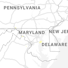
Maryland
| Local Time | Report Details |
|---|---|
| 7:08 PM EDT | Tree and branches down on w willard roa in montgomery county MD, 45.4 miles WSW of Baltimore, MD |
| 7:09 PM EDT | Tree down near the intersection of pettit way and md 19 in montgomery county MD, 40.6 miles WSW of Baltimore, MD |
| 7:10 PM EDT | Tree down on river road near pettit wa in montgomery county MD, 40.6 miles WSW of Baltimore, MD |
| 4:35 AM EDT | Trees blew down on eastbound alternate us-40 old national pike at dahlgren roa in frederick county MD, 55.6 miles WNW of Baltimore, MD |
Utah
| Local Time | Report Details |
|---|---|
| 5:20 PM MDT | State route 72 at hogan pass in sevier county UT, 34.9 miles E of Monroe, UT |
| 6:30 PM MDT | Wellington ameriflux site in emery county UT, 11.3 miles SSE of Price, UT |
| 7:36 PM MDT | Tule valley raws in millard county UT, 81.5 miles E of Ely, NV |
Michigan
| Local Time | Report Details |
|---|---|
| 7:20 PM EDT | Vehicle accident into power pole (accident cause enhanced by storm conditions in berrien county MI, 62.6 miles SW of Grand Rapids, MI |
| 7:22 PM EDT | Large tree down on power line in berrien county MI, 62.7 miles ENE of Chicago, IL |
| 7:25 PM EDT | Large tree down on hous in berrien county MI, 60.7 miles ENE of Chicago, IL |
| 7:35 PM EDT | Report from mping: trees uprooted or snappe in berrien county MI, 58.3 miles SSW of Grand Rapids, MI |
| 7:40 PM EDT | Quarter sized hail reported near Hartford, MI, 56.2 miles SSW of Grand Rapids, MI |
| 7:40 PM EDT | Quarter sized hail reported near Gobles, MI, 44.5 miles SSW of Grand Rapids, MI |
| 7:53 PM EDT | Multiple trees down... including one on a car. reports of flooding around the cit in van buren county MI, 58.1 miles SSW of Grand Rapids, MI |
| 7:55 PM EDT | Small tree limb damage. report of a car on its side. through spotternetwork.org. time estimated by rada in cass county MI, 64.5 miles S of Grand Rapids, MI |
| 8:10 PM EDT | Large tree limb to 5 feet in diameter on bent r in st. joseph county MI, 66.8 miles S of Grand Rapids, MI |
| 8:11 PM EDT | Wind gust report of 70-75 mph from social media near white pigeon in st. joseph county michiga in st. joseph county MI, 57.3 miles NNW of Fort Wayne, IN |
| 8:13 PM EDT | Relayed through spotternetwork.or in st. joseph county MI, 65.9 miles NNW of Fort Wayne, IN |
| 8:14 PM EDT | 2 trees down. damaged campe in van buren county MI, 55.8 miles SSW of Grand Rapids, MI |
| 8:30 PM EDT | Social media report of large tree down across road south of marcellus in cass county michiga in cass county MI, 65 miles S of Grand Rapids, MI |
| 8:30 PM EDT | Public spotter report of 2 small trees down and pea sized hail near three rivers in st. joseph county michiga in st. joseph county MI, 65.7 miles NNW of Fort Wayne, IN |
| 8:32 PM EDT | Social media report of large tree down across us 131 south of three rivers in st. joseph county michiga in st. joseph county MI, 65.7 miles NNW of Fort Wayne, IN |
| 8:38 PM EDT | Asos reports 66 mph gust from ene at three rivers in st. joseph county michiga in st. joseph county MI, 65.7 miles NNW of Fort Wayne, IN |
| 8:50 PM EDT | Spotter report of 5 large trees down south of coldwater in branch county michiga in branch county MI, 59.9 miles N of Fort Wayne, IN |
| 9:00 PM EDT | Report from mping: 1-inch tree limbs broken; shingles blown of in hillsdale county MI, 63 miles NNE of Fort Wayne, IN |
| 12:40 AM EDT | Two inch diameter tree limbs dow in eaton county MI, 60 miles SW of Flint, MI |
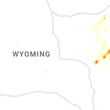
Wyoming
| Local Time | Report Details |
|---|---|
| 5:57 PM MDT | Golf Ball sized hail reported near Manville, WY, 81 miles E of Casper, WY |
| 6:00 PM MDT | Tennis Ball sized hail reported near Manville, WY, 80.1 miles NW of Scottsbluff, NE, mostly quarter size hailstones... with a few hailstones from 2 to 2.5 inches in diameter. |
| 6:35 PM MDT | Hen Egg sized hail reported near Lusk, WY, 85.2 miles NNW of Scottsbluff, NE, hailstones 1.5 to 2 inches in diameter. |
| 7:17 PM MDT | Golf Ball sized hail reported near Lusk, WY, 64.5 miles NW of Scottsbluff, NE, hailstones ranged in size from marbles to golf balls. |
| 7:42 PM MDT | Quarter sized hail reported near Van Tassell, WY, 69 miles NNW of Scottsbluff, NE |
| 8:52 PM MDT | Quarter sized hail reported near Sundance, WY, 56.4 miles WNW of Rapid City, SD |
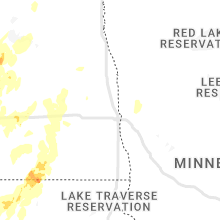
North Dakota
| Local Time | Report Details |
|---|---|
| 7:29 PM CDT | Ndawn station garrison 13nw. sustained wind 41 mp in mclean county ND, 40.5 miles SSW of Minot, ND |
| 7:55 PM CDT | Half Dollar sized hail reported near Douglas, ND, 23.4 miles SSW of Minot, ND, relayed through social media. time estimated from radar. |
| 7:57 PM CDT | Asos station kn60 garriso in mclean county ND, 41 miles S of Minot, ND |
| 10:09 PM CDT | Radar estimated tim in wells county ND, 55.5 miles WSW of Devils Lake, ND |
| 10:12 PM CDT | Ndawn station harvey 2sw. sustained at 43 mp in wells county ND, 56 miles WSW of Devils Lake, ND |
| 10:16 PM CDT | Quarter sized hail reported near Harvey, ND, 55.5 miles WSW of Devils Lake, ND |
| 10:20 PM CDT | Quarter sized hail reported near Martin, ND, 59.7 miles WSW of Devils Lake, ND, pictures submitted via facebook showing estimated quarter sized hail. reporter also estimated 60 mph wind gusts and 1.30 inches of rain. |
| 11:05 PM CDT | Davis personal weather station 2 miles south and 3 miles west of oberon recorded 61 mph wind gus in benson county ND, 23.8 miles SW of Devils Lake, ND |
| 11:15 PM CDT | Corrects previous tstm wnd gst report from 3 sw oberon. davis personal weather station 2 miles south and 3 miles west of oberon recorded 61 mph wind gus in benson county ND, 23.8 miles SW of Devils Lake, ND |
| 11:55 PM CDT | Devils lake cwop wind gust of 59 mph at 1155 p in ramsey county ND, 0.6 miles WSW of Devils Lake, ND |
| 5:00 AM CDT | Tea Cup sized hail reported near Forbes, ND, 36.1 miles NNW of Aberdeen, SD, facebook photo of a hailstone measured to be about 3 inches in diameter. relayed by broadcast media. the reporter says that cars have dents and expects to find damage t |
| 5:20 AM CDT | Quarter sized hail reported near Ellendale, ND, 37.4 miles N of Aberdeen, SD |
| 5:20 AM CDT | Dickey county emergency manager reported numerous trees and powerlines downed in the city of ellendale. quarter sized hail was also reporte in dickey county ND, 38.1 miles N of Aberdeen, SD |
Georgia
| Local Time | Report Details |
|---|---|
| 8:35 PM EDT | Quarter sized hail reported near Dillard, GA, 42.3 miles WNW of Greenville, SC, social media reported nickel to quarter sized hail along spy glass circle. |
South Dakota
| Local Time | Report Details |
|---|---|
| 7:35 PM MDT | Storm damage reported in butte county SD, 44.4 miles NNW of Rapid City, SD |
| 7:43 PM MDT | Quarter sized hail reported near Edgemont, SD, 62 miles SSW of Rapid City, SD |
| 7:55 PM MDT | Tennis Ball sized hail reported near Hot Springs, SD, 51.2 miles SSW of Rapid City, SD |
| 7:58 PM MDT | Ping Pong Ball sized hail reported near Hot Springs, SD, 50.3 miles SSW of Rapid City, SD, hail has been falling for 5 minutes and almost covering the ground |
| 7:58 PM MDT | Golf Ball sized hail reported near Hot Springs, SD, 50.3 miles SSW of Rapid City, SD, hail increased to golf ball size. hail ended at 807 pm. |
| 8:35 PM MDT | Ping Pong Ball sized hail reported near Hot Springs, SD, 61.4 miles SSW of Rapid City, SD, time estimated via radar |
| 8:54 PM MDT | Baseball sized hail reported near Hot Springs, SD, 46.7 miles SSW of Rapid City, SD |
| 8:55 PM MDT | Golf Ball sized hail reported near Hot Springs, SD, 44 miles SSW of Rapid City, SD |
| 9:00 PM MDT | Golf Ball sized hail reported near Hot Springs, SD, 47.1 miles SSW of Rapid City, SD |
| 9:00 PM MDT | Hen Egg sized hail reported near Hot Springs, SD, 47.3 miles SSW of Rapid City, SD |
| 9:10 PM MDT | Grapefruit sized hail reported near Hot Springs, SD, 43.4 miles S of Rapid City, SD, maximum hail size 4 inches. countless baseball size hail on ground. |
| 9:13 PM MDT | Hen Egg sized hail reported near Hot Springs, SD, 47.1 miles SSW of Rapid City, SD |
| 9:34 PM MDT | Storm damage reported in custer county SD, 29.1 miles SSE of Rapid City, SD |
| 10:37 PM MDT | Storm damage reported in pennington county SD, 37.1 miles ESE of Rapid City, SD |
| 10:40 PM MDT | Storm damage reported in pennington county SD, 36.4 miles E of Rapid City, SD |
| 10:45 PM MDT | Storm damage reported in pennington county SD, 51.3 miles ESE of Rapid City, SD |
| 10:56 PM MDT | Tennis Ball sized hail reported near Quinn, SD, 57.9 miles E of Rapid City, SD |
| 10:56 PM MDT | Golf Ball sized hail reported near Wall, SD, 55.4 miles E of Rapid City, SD |
| 10:56 PM MDT | Baseball sized hail reported near Wall, SD, 59.1 miles E of Rapid City, SD |
| 11:10 PM MDT | Storm damage reported in jackson county SD, 69.3 miles E of Rapid City, SD |
| 11:15 PM MDT | Storm damage reported in jackson county SD, 72.3 miles ESE of Rapid City, SD |
| 11:27 PM MDT | Golf Ball sized hail reported near Philip, SD, 66.7 miles WSW of Pierre, SD |
| 11:53 PM MDT | Tea Cup sized hail reported near Wanblee, SD, 75.1 miles ESE of Rapid City, SD, mostly golfball size or smaller |
| 11:55 PM MDT | Storm damage reported in jackson county SD, 72.3 miles ESE of Rapid City, SD |
| 12:01 AM MDT | Storm damage reported in jackson county SD, 69.1 miles NW of Valentine, NE |
| 12:10 AM MDT | Damage around kadoka from wind driven tennis ball size hail...power out in town in jackson county SD, 68.7 miles WSW of Pierre, SD |
| 12:10 AM MDT | Tennis Ball sized hail reported near Kadoka, SD, 68.7 miles WSW of Pierre, SD, damage around kadoka from wind driven tennis ball size hail...power out in town |
| 12:10 AM MDT | Storm damage reported in jackson county SD, 72.3 miles ESE of Rapid City, SD |
| 12:11 AM MDT | Ping Pong Ball sized hail reported near Kadoka, SD, 74.7 miles WSW of Pierre, SD |
| 12:11 AM MDT | Tennis Ball sized hail reported near Kadoka, SD, 68.7 miles WSW of Pierre, SD |
| 12:11 AM MDT | Winds from thunderstorm outflow in jackson county SD, 69.1 miles NW of Valentine, NE |
| 2:14 AM CDT | Storm damage reported in yankton county SD, 53.9 miles SW of Sioux Falls, SD |
| 2:17 AM CDT | Mesonet station 197 sd rwis gayvill in yankton county SD, 52.1 miles SSW of Sioux Falls, SD |
| 2:35 AM CDT | Corrects previous non-tstm wnd gst report from 4 ese rosseau. mesonet station prfs2 pierre 16 ese (sd mesonet in hughes county SD, 17.7 miles ESE of Pierre, SD |
| 2:52 AM CDT | Mesonet station 157 forest city (sddot in potter county SD, 44.4 miles N of Pierre, SD |
| 2:59 AM CDT | Mesonet station 212 sd rwis aga in potter county SD, 39 miles NNE of Pierre, SD |
| 4:05 AM CDT | Some tree branches dow in edmunds county SD, 41 miles W of Aberdeen, SD |
| 4:05 AM CDT | Quarter sized hail reported near Roscoe, SD, 41 miles W of Aberdeen, SD |
| 4:08 AM CDT | Grain bins caved in. trees down. time estimated by rada in edmunds county SD, 41.1 miles W of Aberdeen, SD |
| 4:20 AM CDT | Time estimated by radar. large window broken by object. privacy fence blown ove in hyde county SD, 46.2 miles ENE of Pierre, SD |
| 4:22 AM CDT | Golf Ball sized hail reported near Leola, SD, 28.4 miles NW of Aberdeen, SD, report from mping: golf ball (1.75 in.). |
| 4:25 AM CDT | Ping Pong Ball sized hail reported near Leola, SD, 29.3 miles NW of Aberdeen, SD |
| 4:30 AM CDT | Storm damage reported in edmunds county SD, 13.3 miles W of Aberdeen, SD |
| 4:35 AM CDT | Personal weather statio in mcpherson county SD, 28.4 miles WNW of Aberdeen, SD |
| 4:35 AM CDT | Trees downed... power polls and lines blown down... grain bins downed. time estimated by radar dat in mcpherson county SD, 22.9 miles NW of Aberdeen, SD |
| 4:50 AM CDT | Large trees downed... grain bin downed... power lines and power polls blown over. timing based on radar dat in brown county SD, 26.4 miles N of Aberdeen, SD |
| 4:50 AM CDT | Personal weather statio in mcpherson county SD, 28.6 miles NW of Aberdeen, SD |
| 4:55 AM CDT | Golf Ball sized hail reported near Frederick, SD, 33.4 miles NNW of Aberdeen, SD, facebook report with picture. |
Connect with Interactive Hail Maps