

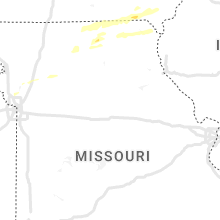
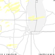
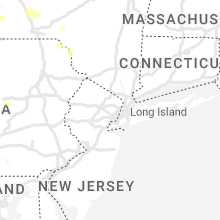
Hail Map for Wednesday, June 15, 2022

Number of Impacted Households on 6/15/2022
0
Impacted by 1" or Larger Hail
0
Impacted by 1.75" or Larger Hail
0
Impacted by 2.5" or Larger Hail
Square Miles of Populated Area Impacted on 6/15/2022
0
Impacted by 1" or Larger Hail
0
Impacted by 1.75" or Larger Hail
0
Impacted by 2.5" or Larger Hail


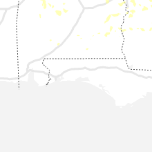


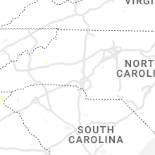


Cities Most Affected by Hail Storms of 6/15/2022
| Hail Size | Demographics of Zip Codes Affected | ||||||
|---|---|---|---|---|---|---|---|
| City | Count | Average | Largest | Pop Density | House Value | Income | Age |
| Lamont, IA | 1 | 2.75 | 2.75 | 11 | $42k | $30.5k | 38.8 |
| Phenix City, AL | 1 | 1.75 | 1.75 | 783 | $89k | $41.2k | 33.0 |
Hail and Wind Damage Spotted on 6/15/2022
Filter by Report Type:Hail ReportsWind Reports
States Impacted
Michigan, Alabama, Iowa, Minnesota, Montana, Wisconsin, North Carolina, Georgia, Florida, New York, KansasMichigan
| Local Time | Report Details |
|---|---|
| 10:28 AM EDT | Escanaba public safety dispatch reports of a damaged tree on a power line near the michigan dnr station in escanab in delta county MI, 53.9 miles SSE of Marquette, MI |
| 10:30 AM EDT | Poplar tree snapped halfway up the tree on the bluff in gladstone. another tree was snapped near the base of the trunk. report via social medi in delta county MI, 51.3 miles SSE of Marquette, MI |
| 7:10 PM CDT | Trees down. report via social media with pictur in menominee county MI, 57 miles SSW of Marquette, MI |
| 9:08 PM EDT | Tree down and large swing blown down. report via social medi in delta county MI, 66.6 miles SE of Marquette, MI |
| 10:31 PM EDT | Awos at chippewa county intl aipor in chippewa county MI, 17.7 miles SSW of Sault Sainte Marie, MI |
| 11:06 PM EDT | A few trees down near bates and sayler r in grand traverse county MI, 8.4 miles ENE of Traverse City, MI |
| 11:06 PM EDT | A few trees down near bates and sayler r in grand traverse county MI, 8.4 miles ENE of Traverse City, MI |
| 4:12 AM EDT | Saginaw international airport wind gus in saginaw county MI, 41 miles NNW of Flint, MI |
| 4:40 AM EDT | Central dispatch reported over a dozen trees downed and snapped across northern tuscola count in tuscola county MI, 37.9 miles N of Flint, MI |
| 4:49 AM EDT | Central dispatch reported scattered trees down in the western and central part of huron county. some locations include sebewaing... owendale... filion... and ubly in huron county MI, 51.6 miles NNE of Flint, MI |
Alabama
| Local Time | Report Details |
|---|---|
| 9:40 AM CDT | A few trees blown down around tro in pike county AL, 62 miles SSW of Auburn, AL |
| 10:06 AM CDT | A few trees blown down around clanto in chilton county AL, 48 miles SSE of Birmingham, AL |
| 4:09 PM CDT | Quarter sized hail reported near Huntsville, AL, 63.3 miles E of Florence, AL, reports of pea to quarter size hail south of huntsville... report relayed via social media. |
| 4:11 PM CDT | Tree and power line damage along marsheutz avenue in huntsvill in madison county AL, 62.6 miles E of Florence, AL |
| 4:15 PM CDT | Corrects previous non-tstm wnd gst report from craig field airport. awos station ksem selma craig fl in dallas county AL, 30.6 miles NE of Camden, AL |
| 4:15 PM CDT | Tree down at the intersection of carl t. jones and garth road. time estimated by rada in madison county AL, 64.6 miles E of Florence, AL |
| 4:20 PM CDT | Quarter sized hail reported near Huntsville, AL, 63.6 miles E of Florence, AL, dime to quarter size hail reported on charlotte drive in south huntsville. report relayed via social media. |
| 5:43 PM CDT | Quarter sized hail reported near Eufaula, AL, 58.6 miles SSE of Auburn, AL, corrects previous hail report from 6 s eufaula country club. hail up to quarter size reported via social media. a few trees reported down in the same area. |
| 6:43 PM CDT | Quarter sized hail reported near Eufaula, AL, 58.6 miles SSE of Auburn, AL, hail up to quarter size reported via social media. a few trees reported down in the same area. |
| 6:44 PM CDT | Trees and powerlines blown dow in jefferson county AL, 8.8 miles SSW of Birmingham, AL |
| 6:59 PM CDT | Golf Ball sized hail reported near Phenix City, AL, 20.8 miles ESE of Auburn, AL, spotter reported golf ball sized hail along hwy 80 near crawford. |
| 7:06 PM CDT | Trees blown down near lee rd 208 in lee county AL, 15.6 miles SE of Auburn, AL |
| 7:28 PM CDT | Several trees down north of moundville. winds estimated at 50-60 mp in tuscaloosa county AL, 56.7 miles SW of Birmingham, AL |
| 7:52 PM CDT | Several trees blown dow in pike county AL, 64.9 miles SSW of Auburn, AL |
| 7:55 PM CDT | One tree down on hwy 5 in dale county AL, 75.7 miles S of Auburn, AL |
| 7:55 PM CDT | Trees blown down... numerous power outages reporte in calhoun county AL, 66.4 miles ENE of Birmingham, AL |
| 8:03 PM CDT | Trees blown dow in randolph county AL, 48.4 miles N of Auburn, AL |
| 8:04 PM CDT | Quarter sized hail reported near Auburn, AL, 7 miles SW of Auburn, AL, reported on social media. |
| 8:13 PM CDT | One tree down at east 27 and east 3 in dale county AL, 79.6 miles S of Auburn, AL |
| 8:15 PM CDT | Trees blown down... power outage in lee county AL, 6.9 miles W of Auburn, AL |
| 8:15 PM CDT | Several reports of trees blown dow in russell county AL, 30.5 miles SSE of Auburn, AL |
| 8:27 PM CDT | Several trees blown down... power outage in randolph county AL, 56.1 miles N of Auburn, AL |
| 8:35 PM CDT | Multiple trees down along county road 30 in coffee county AL, 75.6 miles SSW of Auburn, AL |
| 8:39 PM CDT | Trees blown dow in tallapoosa county AL, 15.7 miles W of Auburn, AL |
| 8:40 PM CDT | One tree dow in coffee county AL, 76 miles SSW of Auburn, AL |
| 8:44 PM CDT | Kanb measured 44 mph wind gust along outflo in calhoun county AL, 55.7 miles E of Birmingham, AL |
| 8:55 PM CDT | Corrects previous tstm wnd dmg report from 6 n choccolocco. trees blown down... numerous power outages reporte in calhoun county AL, 66.4 miles ENE of Birmingham, AL |
| 8:55 PM CDT | Several trees blown down... power outage in elmore county AL, 24.8 miles W of Auburn, AL |
| 9:01 PM CDT | One tree down on forest lake driv in coffee county AL, 75.2 miles NNE of Miramar Beach, FL |
| 9:03 PM CDT | Trees and power lines dow in elmore county AL, 32.1 miles W of Auburn, AL |
| 9:05 PM CDT | Trees blown down... power outage in calhoun county AL, 64 miles ENE of Birmingham, AL |
| 9:05 PM CDT | Trees blown down across southern portions of the count in cherokee county AL, 72.2 miles WNW of Atlanta, GA |
| 9:16 PM CDT | Trees and power lines down around wetumpk in elmore county AL, 42.9 miles W of Auburn, AL |
| 9:27 PM CDT | Several trees down... power outage in etowah county AL, 53.8 miles NE of Birmingham, AL |
| 9:30 PM CDT | Trees and power lines dow in etowah county AL, 57.6 miles NE of Birmingham, AL |
| 9:32 PM CDT | Numerous reports of trees down across etowah county. several have fallen on homes. details pendin in etowah county AL, 54 miles NE of Birmingham, AL |
| 9:32 PM CDT | Several trees and powerlines dow in elmore county AL, 52 miles W of Auburn, AL |
| 9:32 PM CDT | Trees down in raglan in st. clair county AL, 40.5 miles ENE of Birmingham, AL |
| 9:37 PM CDT | Broadcast media relayed pictures of two uprooted pecan trees in the boaz area. time estimated based on rada in marshall county AL, 60.9 miles NE of Birmingham, AL |
| 9:40 PM CDT | Trees down in ashlan in st. clair county AL, 38.7 miles NE of Birmingham, AL |
| 9:40 PM CDT | Corrects previous tstm wnd dmg report from troy. a few trees blown down around tro in pike county AL, 62 miles SSW of Auburn, AL |
| 9:53 PM CDT | Report of multiple trees down in the arab vicinity. time estimated based on rada in marshall county AL, 58.6 miles NNE of Birmingham, AL |
| 10:06 PM CDT | Corrects previous tstm wnd dmg report from clanton. a few trees blown down around clanto in chilton county AL, 48 miles SSE of Birmingham, AL |
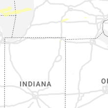
Iowa
| Local Time | Report Details |
|---|---|
| 10:10 AM CDT | Trees and power lines downe in floyd county IA, 13.7 miles E of Mason City, IA |
| 10:20 AM CDT | Branches around 3 inches in diameter down with pea size hail. half an inch of rain in 5 minute in floyd county IA, 29.9 miles E of Mason City, IA |
| 4:35 PM CDT | Branches of unknown size down west of epwort in dubuque county IA, 49.5 miles NE of Cedar Rapids, IA |
| 5:05 PM CDT | Quarter sized hail reported near Winthrop, IA, 41 miles N of Cedar Rapids, IA, time estimated from radar... report from mping: quarter (1.00 in.). |
| 5:09 PM CDT | Baseball sized hail reported near Lamont, IA, 43 miles N of Cedar Rapids, IA, relayed from county sheriff office... time estimated from radar. |
| 5:13 PM CDT | Quarter sized hail reported near Lamont, IA, 41.8 miles N of Cedar Rapids, IA, storms moving at a good clip - wind 35-40 mph. |
| 7:08 PM CDT | Storm damage reported in muscatine county IA, 49.5 miles SE of Cedar Rapids, IA |
| 7:08 PM CDT | Report from mping: 3-inch tree limbs broken; power poles broke in muscatine county IA, 48.8 miles SE of Cedar Rapids, IA |
| 7:13 PM CDT | Relayed a report from fire department of tree down and transformer on fire at this locatio in muscatine county IA, 49.6 miles SE of Cedar Rapids, IA |
| 8:23 PM CDT | Quarter sized hail reported near Cantril, IA, 24.6 miles NW of Kahoka, MO, reported near the lodge at windy ridge... time estimated from radar. |
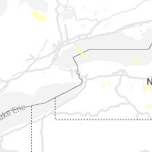
Minnesota
| Local Time | Report Details |
|---|---|
| 10:30 AM CDT | Quarter sized hail reported near Fountain, MN, 44.2 miles W of La Crosse, WI, dime up to quarter sized hail. |
| 11:02 AM CDT | Reports of trees down and some structural damage just south of harmon in fillmore county MN, 42.4 miles WSW of La Crosse, WI |
| 11:34 AM CDT | Trees and power lines down just to the northwest of caledoni in houston county MN, 17.7 miles SW of La Crosse, WI |
Montana
| Local Time | Report Details |
|---|---|
| 10:41 AM MDT | Manning corral raws in phillips county MT, 80.7 miles SE of Havre, MT |
Wisconsin
| Local Time | Report Details |
|---|---|
| 11:50 AM CDT | Quarter sized hail reported near Stoddard, WI, 10.7 miles S of La Crosse, WI |
| 11:53 AM CDT | Corrects previous tstm wnd dmg report from 4 sse la crosse. numerous trees and branches down... including one large tree uproote in la crosse county WI, 3.3 miles SSE of La Crosse, WI |
| 12:41 PM CDT | Numerous trees and branches down... including one large tree uproote in la crosse county WI, 3.3 miles SSE of La Crosse, WI |
| 3:43 PM CDT | Also reported pea size hai in grant county WI, 61.9 miles SSE of La Crosse, WI |
| 4:06 PM CDT | Quarter sized hail reported near Tomah, WI, 39.1 miles ENE of La Crosse, WI |
| 4:12 PM CDT | Trees downs blocking road at county a and state highway 13 in monroe county WI, 38.5 miles E of La Crosse, WI |
| 4:18 PM CDT | Trees down and small shed damaged. county u and keats roa in monroe county WI, 34.2 miles E of La Crosse, WI |
| 4:24 PM CDT | Tree de-barking damag in monroe county WI, 46.7 miles ENE of La Crosse, WI |
| 4:29 PM CDT | Report from mping: 1-inch tree limbs broken; shingles blown of in grant county WI, 62.6 miles WSW of Madison, WI |
| 4:45 PM CDT | Multiple sheds and small outbuildings moved by wind... rolled over... or destroye in richland county WI, 49.5 miles WNW of Madison, WI |
| 4:47 PM CDT | Confirmed tornado. damage to hospital and ground in juneau county WI, 58.6 miles E of La Crosse, WI |
| 4:50 PM CDT | Flipped trailers and poles down. roofs blown over. time estimated from rada in juneau county WI, 58.6 miles E of La Crosse, WI |
| 4:57 PM CDT | Trees down in the city of wausa in marathon county WI, 48 miles SSW of Rhinelander, WI |
| 4:58 PM CDT | Report from mping: 3-inch tree limbs broken; power poles broke in juneau county WI, 59.1 miles E of La Crosse, WI |
| 5:01 PM CDT | Trees down and irrigation equipment flipped near easton. report via nws mk in adams county WI, 56.9 miles NNW of Madison, WI |
| 5:02 PM CDT | Corrects previous tstm wnd dmg report from 5 nnw stevens point. trees dow in portage county WI, 74.2 miles S of Rhinelander, WI |
| 5:02 PM CDT | Tree branches down... pea-sized hai in juneau county WI, 51 miles NNW of Madison, WI |
| 5:04 PM CDT | Corrects previous tstm wnd dmg report from 4 nnw stevens point. report from mping: 3-inch tree limbs broken; power poles broke in portage county WI, 75 miles S of Rhinelander, WI |
| 5:04 PM CDT | Corrects previous tstm wnd dmg report from 4 nnw stevens point. tree limbs broke in portage county WI, 74.3 miles S of Rhinelander, WI |
| 5:05 PM CDT | Street signs down... signal lights damage in juneau county WI, 58.6 miles E of La Crosse, WI |
| 5:05 PM CDT | 2 inch limbs down... time estimated on rada in sauk county WI, 44.2 miles NW of Madison, WI |
| 5:05 PM CDT | Several trees snapped in twin bluffs and sextonville are in richland county WI, 47.8 miles WNW of Madison, WI |
| 5:15 PM CDT | Structure damage to a house and two campers. damage continues towards hwy 82 and cannon av in vernon county WI, 40 miles ESE of La Crosse, WI |
| 5:18 PM CDT | Report from mping: 1-inch tree limbs broken; shingles blown of in adams county WI, 58.7 miles NNW of Madison, WI |
| 5:20 PM CDT | Report from mping: 3-inch tree limbs broken; power poles broke in juneau county WI, 60.1 miles E of La Crosse, WI |
| 5:22 PM CDT | Trees and powerlines dow in waushara county WI, 65.8 miles N of Madison, WI |
| 5:23 PM CDT | Reports of multiple trees and limbs down around town with estimate 60-70 mph wind in marquette county WI, 56 miles N of Madison, WI |
| 5:25 PM CDT | Tree limbs dow in waushara county WI, 66 miles N of Madison, WI |
| 5:26 PM CDT | Storm damage reported in marquette county WI, 61.3 miles N of Madison, WI |
| 5:28 PM CDT | Corrects previous tstm wnd gst report from wautom in waushara county WI, 68.4 miles N of Madison, WI |
| 5:30 PM CDT | Trees down. shingles blown off house in waushara county WI, 69 miles N of Madison, WI |
| 5:32 PM CDT | Trees uprooted or snapped. a roof blown of in waushara county WI, 67.2 miles N of Madison, WI |
| 5:32 PM CDT | Reports of multiple trees down in communities from oxford to the north in marquette count in marquette county WI, 49.6 miles N of Madison, WI |
| 5:34 PM CDT | Multiple semis tipped over on i-90/94... mostly in eastbound lan in monroe county WI, 38.4 miles ENE of La Crosse, WI |
| 5:37 PM CDT | Report from mping: 1-inch tree limbs broken; shingles blown of in waushara county WI, 68.2 miles N of Madison, WI |
| 5:39 PM CDT | Tree and power lines dow in waushara county WI, 68.9 miles N of Madison, WI |
| 5:39 PM CDT | Storm damage reported in waushara county WI, 63.1 miles WSW of Green Bay, WI |
| 5:40 PM CDT | Trees and power lines dow in waushara county WI, 68.9 miles N of Madison, WI |
| 5:41 PM CDT | Tree limbs dow in waushara county WI, 61 miles SW of Green Bay, WI |
| 5:41 PM CDT | Report from mping: 3-inch tree limbs broken; power poles broke in waushara county WI, 69 miles N of Madison, WI |
| 5:41 PM CDT | Tree went through roof of house. time estimated on rada in sauk county WI, 23.9 miles NNW of Madison, WI |
| 5:42 PM CDT | Trees down along highway 2 in shawano county WI, 58 miles WNW of Green Bay, WI |
| 5:44 PM CDT | Report from mping: 1-inch tree limbs broken; shingles blown of in waushara county WI, 59.1 miles WSW of Green Bay, WI |
| 5:45 PM CDT | Report of multiple trees down on social media. time estimated on rada in columbia county WI, 22.7 miles NNW of Madison, WI |
| 5:56 PM CDT | Corrects previous tstm wnd dmg report from manawa. trees dow in waupaca county WI, 44.6 miles W of Green Bay, WI |
| 5:59 PM CDT | Trees dow in winnebago county WI, 37.6 miles SW of Green Bay, WI |
| 5:59 PM CDT | Report from mping: trees uprooted or snapped; roof blown of in winnebago county WI, 39.6 miles WSW of Green Bay, WI |
| 6:00 PM CDT | Social media report of winds causing roof damage as well a damage to a boat on swan lake. time estimate based on rada in columbia county WI, 33 miles N of Madison, WI |
| 6:05 PM CDT | Trees dow in outagamie county WI, 29.1 miles WSW of Green Bay, WI |
| 6:06 PM CDT | Report from mping: 3-inch tree limbs broken; power poles broke in portage county WI, 75 miles S of Rhinelander, WI |
| 6:07 PM CDT | Tree limbs broke in portage county WI, 74.3 miles S of Rhinelander, WI |
| 6:08 PM CDT | Trees dow in portage county WI, 74.2 miles S of Rhinelander, WI |
| 6:11 PM CDT | Barn was reported down via emergency manage in outagamie county WI, 22.5 miles W of Green Bay, WI |
| 6:12 PM CDT | Emergency manager reports numerous trees and power lines downed and blocking highways and roads between black creek and freedom. time based on radar estimate. delayed r in outagamie county WI, 18.4 miles WSW of Green Bay, WI |
| 6:12 PM CDT | Trees uprooted or snapped. roof was blown of in oconto county WI, 51.9 miles NNW of Green Bay, WI |
| 6:14 PM CDT | Multiple trees snapped and power lines dow in outagamie county WI, 25.9 miles SW of Green Bay, WI |
| 6:14 PM CDT | Trees were snapped and power lines dow in outagamie county WI, 26.3 miles SW of Green Bay, WI |
| 6:14 PM CDT | Numerous trees down in the area. time estimated on rada in green lake county WI, 55.2 miles NNE of Madison, WI |
| 6:15 PM CDT | Storm damage reported in outagamie county WI, 26 miles SW of Green Bay, WI |
| 6:16 PM CDT | Powerlines down across the road and a shed partly damage in columbia county WI, 34.5 miles N of Madison, WI |
| 6:16 PM CDT | Trees and power lines dow in outagamie county WI, 26.3 miles SW of Green Bay, WI |
| 6:17 PM CDT | Trees uprooted or snappe in oconto county WI, 51.9 miles NNW of Green Bay, WI |
| 6:18 PM CDT | Multiple trees snapped in the cit in outagamie county WI, 15.8 miles W of Green Bay, WI |
| 6:18 PM CDT | Barn reported down via emergency manage in brown county WI, 8.9 miles W of Green Bay, WI |
| 6:22 PM CDT | Trees and power lines down on lovers lane just south of markesa in green lake county WI, 46.2 miles NNE of Madison, WI |
| 6:23 PM CDT | Trees and power lines dow in outagamie county WI, 16.1 miles WNW of Green Bay, WI |
| 6:25 PM CDT | Storm damage reported in brown county WI, 0.5 miles ESE of Green Bay, WI |
| 6:25 PM CDT | Trained spotter reported multiple 12 to 18 inch diameter trees down. time estimated via radar. delayed repor in brown county WI, 4.5 miles W of Green Bay, WI |
| 6:25 PM CDT | Numerous trees down in the area. time estimated on rada in columbia county WI, 27.4 miles NNE of Madison, WI |
| 6:27 PM CDT | Multiple trees down on laredo lan in brown county WI, 0.5 miles ESE of Green Bay, WI |
| 6:30 PM CDT | Wind estimated around 60 mph. trees and power lines dow in marinette county WI, 49.5 miles N of Green Bay, WI |
| 6:31 PM CDT | Several trees down. a few roads were impassable due to the fallen tree in brown county WI, 3.6 miles NW of Green Bay, WI |
| 6:39 PM CDT | Report of trees down and collapsed roofs. time and location estimated from radar. delayed repor in marinette county WI, 59.9 miles N of Green Bay, WI |
| 6:39 PM CDT | 20 inch branches dow in brown county WI, 9 miles E of Green Bay, WI |
| 6:45 PM CDT | Reports of numerous trees down in the beaver dam area. time estimated on rada in dodge county WI, 38.4 miles NE of Madison, WI |
| 6:50 PM CDT | Reports of numerous trees and powerlines down in the area. time estimated on rada in dane county WI, 3.2 miles W of Madison, WI |
| 6:50 PM CDT | Pine trees snapped and large limbs dow in columbia county WI, 22.7 miles NE of Madison, WI |
| 6:59 PM CDT | Multiple trees snapped in the cit in outagamie county WI, 15.8 miles W of Green Bay, WI |
| 6:59 PM CDT | Fire department report of multiple trees and power lines down near sturgeon bay and wi hwy 42. time estimated from rada in door county WI, 36.8 miles NE of Green Bay, WI |
| 7:18 PM CDT | Corrects time previous tstm wnd dmg report from waterloo. downed branches around 1.75 to 2.75 inches in diamete in jefferson county WI, 21.4 miles ENE of Madison, WI |
| 7:51 PM CDT | Powerlines dow in jefferson county WI, 23.3 miles ESE of Madison, WI |
| 7:58 PM CDT | Small tree and lots of branches dow in jefferson county WI, 26 miles ESE of Madison, WI |
| 8:15 PM CDT | Powerlines down on road. time estimated on rada in jefferson county WI, 38.9 miles E of Madison, WI |
| 8:20 PM CDT | Large branches dow in sheboygan county WI, 56.4 miles SSE of Green Bay, WI |
| 8:20 PM CDT | Downed branches around 1.75 to 2.75 inches in diamete in jefferson county WI, 21.4 miles ENE of Madison, WI |
| 9:34 PM CDT | Reports of numerous trees and power lines down. time estimated on rada in ozaukee county WI, 77.8 miles S of Green Bay, WI |
| 10:27 PM CDT | Half Dollar sized hail reported near Two Rivers, WI, 33.2 miles SE of Green Bay, WI |
| 10:29 PM CDT | Ping Pong Ball sized hail reported near Two Rivers, WI, 32.7 miles SE of Green Bay, WI, gusty winds also occurred. |
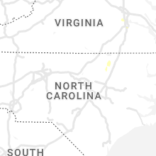
North Carolina
| Local Time | Report Details |
|---|---|
| 6:08 PM EDT | Quarter sized hail reported near Nebo, NC, 61.9 miles SSE of Bristol, TN, observed at the golf course. |
| 6:10 PM EDT | Several trees dow in clay county NC, 61.1 miles S of Knoxville, TN |
| 6:24 PM EDT | Several trees dow in cherokee county NC, 53.8 miles S of Knoxville, TN |
| 6:35 PM EDT | Quarter sized hail reported near Marion, NC, 61.2 miles S of Bristol, TN, observed off of hankins and fish hatchery roads. |
Georgia
| Local Time | Report Details |
|---|---|
| 6:10 PM EDT | Quarter sized hail reported near Peachtree City, GA, 27.6 miles SSW of Atlanta, GA, 1 inch hail observed at balmoral village near s peachtree pkwy. |
| 6:10 PM EDT | 1 tree down in carroll county GA, 34 miles WSW of Atlanta, GA |
| 6:16 PM EDT | Quarter sized hail reported near Sharpsburg, GA, 29.4 miles SSW of Atlanta, GA, 1 inch hail observed on macintosh estates ct. |
| 6:16 PM EDT | Tree reported down in a yard on macintosh estates c in coweta county GA, 29.4 miles SSW of Atlanta, GA |
| 6:16 PM EDT | Half Dollar sized hail reported near Peachtree City, GA, 26.8 miles SSW of Atlanta, GA, half dollar size hail reported near intersection of driftwood ct and fishers luck. |
| 6:16 PM EDT | Multiple trees down near intersection of joel cowan pkwy and kelly dr in fayette county GA, 27.6 miles SSW of Atlanta, GA |
| 6:22 PM EDT | Tree reported down across the road on hwy 54 near intersection with sunset d in coweta county GA, 31.6 miles SSW of Atlanta, GA |
| 6:23 PM EDT | Tree down on home with structural damage near the intersection of tower rd and wynnmeade pkwy in fayette county GA, 27.1 miles SSW of Atlanta, GA |
| 6:33 PM EDT | Tree and powerline reported down at the intersection of s hwy 29 and oaklawn r in coweta county GA, 36.5 miles SW of Atlanta, GA |
| 6:35 PM EDT | Quarter sized hail reported near Upatoi, GA, 43.5 miles E of Auburn, AL, quarter size hail reported in utapoi |
| 6:40 PM EDT | Tree down at the intersection of ginn lake and ginn d in harris county GA, 38.7 miles E of Auburn, AL |
| 6:40 PM EDT | Multiple trees down near the intersection of harris rd and ginn dr in harris county GA, 39.3 miles E of Auburn, AL |
| 6:41 PM EDT | Tree down near the intersection harris rd and ga-208 in harris county GA, 40.1 miles E of Auburn, AL |
| 6:44 PM EDT | Tree reported down at the intersection of hwy 27 and lake lorraine d in harris county GA, 37.8 miles ENE of Auburn, AL |
| 6:46 PM EDT | Tree reported down at the intersection of hwy 315 and old warm springs r in harris county GA, 38.6 miles E of Auburn, AL |
| 6:55 PM EDT | Tree down at the intersection of nelson rd and pleasant grove r in harris county GA, 35.6 miles ENE of Auburn, AL |
| 6:57 PM EDT | Tree reported down at the intersection of hwy 116 and rd brown r in harris county GA, 33.1 miles ENE of Auburn, AL |
| 7:10 PM EDT | 2 trees down in carroll county GA, 34.8 miles WSW of Atlanta, GA |
| 7:18 PM EDT | Multiple trees down along mt vernon church rd near intersection of mountain view rd in butts county GA, 43.5 miles SE of Atlanta, GA |
| 7:20 PM EDT | Several trees reported down at the intersection of hwy 85 and main st. traffic light blown off pol in meriwether county GA, 54.2 miles SSW of Atlanta, GA |
| 7:22 PM EDT | Tree down at the intersection of hwy 103 and goose creek r in harris county GA, 26.3 miles ENE of Auburn, AL |
| 7:25 PM EDT | Roof blown off of a home on dromedary s in meriwether county GA, 54.1 miles SSW of Atlanta, GA |
| 7:34 PM EDT | Tree and powerlines down across high falls park rd near bell r in lamar county GA, 41.6 miles SSE of Atlanta, GA |
| 7:52 PM EDT | Trees snapped in northern clay count in clay county GA, 65.6 miles SSE of Auburn, AL |
| 8:35 PM EDT | Pine mountain asos (kpim) measured a 53 kt (61 mph) gust at 0035 in harris county GA, 38.5 miles ENE of Auburn, AL |
| 8:50 PM EDT | Quarter sized hail reported near Tiger, GA, 43.2 miles W of Greenville, SC, observed along east wolf creek road... relayed through rabun co wx facebook page. |
| 9:10 PM EDT | Quarter sized hail reported near Carrollton, GA, 40.7 miles WSW of Atlanta, GA, quarter size hail reported near intersection of pleasant ridge ch rd and ga-113 |
| 9:12 PM EDT | 1 tree fell on a house in carroll county GA, 37.5 miles W of Atlanta, GA |
| 9:12 PM EDT | 1 tree fell on a mobile home in haralson county GA, 39.7 miles W of Atlanta, GA |
| 9:15 PM EDT | A tree fell on a house in carroll county GA, 40.8 miles WSW of Atlanta, GA |
| 9:20 PM EDT | Numerous trees down in carroll county GA, 51.5 miles WSW of Atlanta, GA |
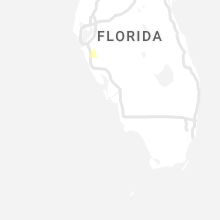
Florida
| Local Time | Report Details |
|---|---|
| 6:30 PM EDT | Quarter sized hail reported near Bradenton, FL, 9.2 miles E of Bradenton, FL, public reported quarter size hail along ft. hamer road and ft. hamer bridge near manatee river. |
| 7:00 PM EDT | Asos station ksrq sarasota bradento in manatee county FL, 6.6 miles S of Bradenton, FL |
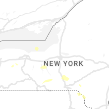
New York
| Local Time | Report Details |
|---|---|
| 8:29 PM EDT | Tree down and then snapped off a power pol in wyoming county NY, 43.1 miles E of Buffalo, NY |
| 2:20 AM EDT | Large tree down on route 38 between stony hill rd and tucker hill r in cayuga county NY, 31.3 miles SSW of Syracuse, NY |
| 3:23 AM EDT | Tree down blocking the roadway. hooper rd and pheasant l in broome county NY, 52.4 miles NNW of Scranton, PA |
Kansas
| Local Time | Report Details |
|---|---|
| 9:20 PM CDT | Reports of power flashes... tree damage... shingles off some roofs in the southern part of madison along oak street. this is a preliminary report of thunderstorm wind d in greenwood county KS, 48.7 miles NW of Chanute, KS |
| 9:20 PM CDT | Reported tin roof ripped off a business in eastern part of madison. numerous large tree limbs knocked down and a large tree with several large limbs stripped. this is a in greenwood county KS, 48.2 miles NW of Chanute, KS |
| 10:45 PM CDT | Quarter sized hail reported near Hamilton, KS, 44.7 miles WNW of Chanute, KS |
Connect with Interactive Hail Maps