

Hail Map for Friday, June 18, 2021

Number of Impacted Households on 6/18/2021
0
Impacted by 1" or Larger Hail
0
Impacted by 1.75" or Larger Hail
0
Impacted by 2.5" or Larger Hail
Square Miles of Populated Area Impacted on 6/18/2021
0
Impacted by 1" or Larger Hail
0
Impacted by 1.75" or Larger Hail
0
Impacted by 2.5" or Larger Hail


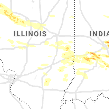


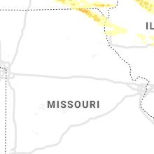
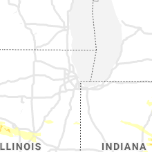
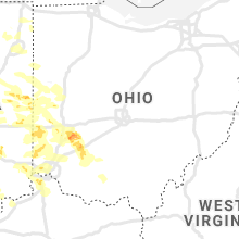
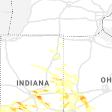
Cities Most Affected by Hail Storms of 6/18/2021
| Hail Size | Demographics of Zip Codes Affected | ||||||
|---|---|---|---|---|---|---|---|
| City | Count | Average | Largest | Pop Density | House Value | Income | Age |
| Indianapolis, IN | 10 | 1.98 | 3.25 | 2126 | $132k | $54.7k | 35.1 |
| New Palestine, IN | 6 | 2.65 | 3.40 | 417 | $154k | $69.1k | 41.8 |
| Cloverdale, IN | 5 | 2.20 | 3.00 | 61 | $92k | $41.5k | 42.5 |
| Dayton, OH | 2 | 2.13 | 2.50 | 1306 | $117k | $44.5k | 42.0 |
| Bridgewater, IA | 1 | 4.00 | 4.00 | 5 | $21k | $30.2k | 47.0 |
| Martinsville, IN | 2 | 1.75 | 1.75 | 160 | $115k | $45.8k | 40.4 |
| Lorimor, IA | 1 | 3.00 | 3.00 | 10 | $44k | $31.9k | 44.2 |
| Griswold, IA | 1 | 2.50 | 2.50 | 9 | $56k | $34.8k | 45.5 |
| Russell, IA | 1 | 2.50 | 2.50 | 9 | $42k | $33.9k | 44.1 |
| Markleville, IN | 1 | 2.00 | 2.00 | 89 | $87k | $46.4k | 40.1 |
| Knoxville, IA | 1 | 2.00 | 2.00 | 67 | $75k | $38.9k | 41.3 |
| Elliott, IA | 1 | 2.00 | 2.00 | 5 | $37k | $38.4k | 43.8 |
| Chariton, IA | 1 | 2.00 | 2.00 | 32 | $54k | $30.6k | 44.0 |
| Oakland, IA | 1 | 1.75 | 1.75 | 19 | $79k | $38.5k | 42.5 |
| Xenia, OH | 1 | 1.75 | 1.75 | 272 | $91k | $41.4k | 40.9 |
| Gosport, IN | 1 | 1.75 | 1.75 | 44 | $90k | $39.0k | 41.5 |
| Orient, IA | 1 | 1.75 | 1.75 | 7 | $54k | $38.8k | 42.6 |
| Burlington, KY | 1 | 1.75 | 1.75 | 380 | $132k | $57.4k | 34.8 |
| Melrose, IA | 1 | 1.75 | 1.75 | 7 | $48k | $37.3k | 54.6 |
| Redkey, IN | 1 | 1.75 | 1.75 | 45 | $58k | $35.1k | 40.8 |
| New Castle, IN | 1 | 1.75 | 1.75 | 191 | $81k | $36.6k | 41.3 |
Hail and Wind Damage Spotted on 6/18/2021
Filter by Report Type:Hail ReportsWind Reports
Michigan
| Local Time | Report Details |
|---|---|
| 8:00 AM EDT | Em reports numerous trees and powerlines blown down across the count in hillsdale county MI, 63.6 miles NNE of Fort Wayne, IN |
| 8:24 AM EDT | Single trees down in the city of adrian reported by amateur radio group and lenawee county dispatc in lenawee county MI, 78.8 miles SSW of Flint, MI |
Indiana
| Local Time | Report Details |
|---|---|
| 8:05 AM EDT | Tree in roadwa in de kalb county IN, 20.4 miles N of Fort Wayne, IN |
| 8:05 AM EDT | Tree fell onto a house and took down phone lines. time estimated from rada in de kalb county IN, 25.3 miles N of Fort Wayne, IN |
| 8:08 AM EDT | Tree blocking roadwa in de kalb county IN, 21.6 miles NNE of Fort Wayne, IN |
| 8:10 AM EDT | Tree blocking the west lane of the roadway. time estimated from rada in de kalb county IN, 33.3 miles NNE of Fort Wayne, IN |
| 8:20 AM EDT | Tree that fell into wires. both are in the roadway. time estimated from rada in de kalb county IN, 19.7 miles N of Fort Wayne, IN |
| 8:27 AM EDT | Large limb fell onto a house... motorhome and power lines. time estimated from rada in de kalb county IN, 17.8 miles NNE of Fort Wayne, IN |
| 8:42 AM EDT | Powerlines dow in allen county IN, 12.6 miles NE of Fort Wayne, IN |
| 3:27 PM EDT | Quarter sized hail reported near Muncie, IN, 54 miles NE of Indianapolis, IN, estimated quarter size hail near hwy 35 and 67. |
| 4:34 PM EDT | Quarter sized hail reported near Dunkirk, IN, 49 miles S of Fort Wayne, IN, dime to quarter size hail. |
| 4:35 PM EDT | Golf Ball sized hail reported near Redkey, IN, 50.1 miles S of Fort Wayne, IN, delayed report. |
| 5:12 PM EDT | Quarter sized hail reported near Ridgeville, IN, 55.9 miles S of Fort Wayne, IN |
| 6:42 PM EDT | Quarter sized hail reported near Indianapolis, IN, 11.9 miles N of Indianapolis, IN |
| 6:44 PM EDT | Half Dollar sized hail reported near Carmel, IN, 12.1 miles N of Indianapolis, IN |
| 6:47 PM EDT | Quarter sized hail reported near Carmel, IN, 13.7 miles NNE of Indianapolis, IN |
| 6:48 PM EDT | Quarter sized hail reported near Indianapolis, IN, 10.1 miles NNE of Indianapolis, IN |
| 6:50 PM EDT | Quarter sized hail reported near Indianapolis, IN, 10 miles NNE of Indianapolis, IN |
| 6:50 PM EDT | Ping Pong Ball sized hail reported near Indianapolis, IN, 9.7 miles NNE of Indianapolis, IN |
| 6:50 PM EDT | Hen Egg sized hail reported near Indianapolis, IN, 10 miles NNE of Indianapolis, IN |
| 6:51 PM EDT | Half Dollar sized hail reported near Indianapolis, IN, 11.3 miles N of Indianapolis, IN |
| 6:55 PM EDT | Golf Ball sized hail reported near Indianapolis, IN, 10.6 miles NNE of Indianapolis, IN |
| 6:55 PM EDT | Golf Ball sized hail reported near Indianapolis, IN, 11.5 miles N of Indianapolis, IN |
| 6:56 PM EDT | Half Dollar sized hail reported near Indianapolis, IN, 9.4 miles NE of Indianapolis, IN |
| 6:58 PM EDT | Quarter sized hail reported near Indianapolis, IN, 8.6 miles NNE of Indianapolis, IN |
| 6:58 PM EDT | Golf Ball sized hail reported near Indianapolis, IN, 10.8 miles NNE of Indianapolis, IN |
| 6:58 PM EDT | Quarter sized hail reported near Union City, IN, 56.1 miles SSE of Fort Wayne, IN |
| 6:59 PM EDT | Tree down across road. reports of storm related power outages across town as well. time estimated from rada in hancock county IN, 19.9 miles NE of Indianapolis, IN |
| 7:00 PM EDT | Hen Egg sized hail reported near Indianapolis, IN, 10.6 miles NNE of Indianapolis, IN, time estimated from radar. |
| 7:00 PM EDT | Quarter sized hail reported near Mc Cordsville, IN, 16.7 miles NE of Indianapolis, IN |
| 7:02 PM EDT | Quarter sized hail reported near Mc Cordsville, IN, 15.3 miles NE of Indianapolis, IN |
| 7:07 PM EDT | Hen Egg sized hail reported near Indianapolis, IN, 12.4 miles NE of Indianapolis, IN |
| 7:10 PM EDT | Golf Ball sized hail reported near Indianapolis, IN, 11.1 miles NE of Indianapolis, IN, time estimated from radar. social media post from lawrence. photo with two 1.75 inch stones next to a quarter. several other stones 1.00 to 1.50 inches. |
| 7:12 PM EDT | Golf Ball sized hail reported near Cloverdale, IN, 38 miles WSW of Indianapolis, IN |
| 7:20 PM EDT | Trees down and some house damage near intersection of home and maple street in madison county IN, 31.8 miles ENE of Indianapolis, IN |
| 7:20 PM EDT | Golf Ball sized hail reported near Indianapolis, IN, 7.8 miles ENE of Indianapolis, IN |
| 7:20 PM EDT | Hen Egg sized hail reported near Markleville, IN, 31.3 miles ENE of Indianapolis, IN, several trees down as well. |
| 7:21 PM EDT | Quarter sized hail reported near Mooresville, IN, 19.3 miles SW of Indianapolis, IN |
| 7:22 PM EDT | Hen Egg sized hail reported near Cloverdale, IN, 38 miles WSW of Indianapolis, IN |
| 7:30 PM EDT | Golf Ball sized hail reported near Indianapolis, IN, 6.7 miles ESE of Indianapolis, IN |
| 7:30 PM EDT | Tennis Ball sized hail reported near Cloverdale, IN, 38.6 miles WSW of Indianapolis, IN, time estimated from radar. size estimated from photo. |
| 7:30 PM EDT | Tea Cup sized hail reported near Cloverdale, IN, 34.7 miles WSW of Indianapolis, IN, time estimated from radar. report from 775 east. |
| 7:35 PM EDT | Storm damage reported in henry county IN, 42 miles ENE of Indianapolis, IN |
| 7:35 PM EDT | Golf Ball sized hail reported near New Castle, IN, 42 miles ENE of Indianapolis, IN |
| 7:40 PM EDT | Quarter sized hail reported near New Palestine, IN, 13 miles E of Indianapolis, IN |
| 7:40 PM EDT | Tea Cup sized hail reported near Indianapolis, IN, 11.2 miles E of Indianapolis, IN, time estimated from radar. |
| 7:40 PM EDT | Golf Ball sized hail reported near Cloverdale, IN, 34.7 miles WSW of Indianapolis, IN, large tree down as well. |
| 7:40 PM EDT | Hen Egg sized hail reported near New Palestine, IN, 14.5 miles E of Indianapolis, IN |
| 7:43 PM EDT | Tree down across road. time estimated from rada in hancock county IN, 13 miles E of Indianapolis, IN |
| 7:44 PM EDT | Quarter sized hail reported near New Castle, IN, 41.3 miles ENE of Indianapolis, IN |
| 7:47 PM EDT | Quarter sized hail reported near Indianapolis, IN, 9.7 miles ESE of Indianapolis, IN |
| 7:47 PM EDT | Trees dow in henry county IN, 39.7 miles ENE of Indianapolis, IN |
| 7:50 PM EDT | Tennis Ball sized hail reported near New Palestine, IN, 14.2 miles ESE of Indianapolis, IN |
| 7:50 PM EDT | Tea Cup sized hail reported near New Palestine, IN, 14.2 miles ESE of Indianapolis, IN |
| 7:50 PM EDT | Tea Cup sized hail reported near New Palestine, IN, 14.2 miles ESE of Indianapolis, IN, time estimated from radar. photographed next to tape measure. |
| 7:54 PM EDT | Golf Ball sized hail reported near New Palestine, IN, 14.5 miles E of Indianapolis, IN |
| 7:54 PM EDT | Trees and power lines blown down across the count in wayne county IN, 59.7 miles E of Indianapolis, IN |
| 7:55 PM EDT | Tea Cup sized hail reported near New Palestine, IN, 13.7 miles ESE of Indianapolis, IN, time estimated from radar. |
| 7:59 PM EDT | Storm damage reported in shelby county IN, 22.7 miles SE of Indianapolis, IN |
| 8:00 PM EDT | Time estimated from radar. mature tree snapped at base. few power lines and poles blown over. large segment of metal barn roof blown off. several branches blown down. 3 in shelby county IN, 18.7 miles ESE of Indianapolis, IN |
| 8:00 PM EDT | Time estimated from radar. top segment of slio blown off. 2582 west 800 nort in shelby county IN, 19.2 miles ESE of Indianapolis, IN |
| 8:00 PM EDT | Time estimated from radar. top half of tree snapped off. another tree uprooted and into barn door. 1377 west 900 nort in shelby county IN, 19.8 miles ESE of Indianapolis, IN |
| 8:00 PM EDT | Time estimated from radar. larger tree uprooted... smaller tree snapped. 1949w 900 in shelby county IN, 19.3 miles ESE of Indianapolis, IN |
| 8:00 PM EDT | Time estimated from radar. 900n impassable from 200w to 400w with trees and powerlines on road. 5 trees in a row downed at 325 in shelby county IN, 18.4 miles ESE of Indianapolis, IN |
| 8:13 PM EDT | Large tree down and fell on deck. reports of other trees down nearby. time estimated from rada in morgan county IN, 34.5 miles SW of Indianapolis, IN |
| 8:40 PM EDT | Quarter sized hail reported near Unionville, IN, 37.2 miles SSW of Indianapolis, IN |
| 8:44 PM EDT | Roof off a buildin in decatur county IN, 46 miles WNW of Cincinnati, OH |
| 8:45 PM EDT | Trees and power lines were blown down across the county. a house was struck by lightning at hidden valley lak in dearborn county IN, 28.8 miles WNW of Cincinnati, OH |
| 8:47 PM EDT | Tree reported into a house. no injuries. time estimated from rada in ripley county IN, 39.7 miles W of Cincinnati, OH |
| 8:47 PM EDT | Trees down across northeastern decatur count in decatur county IN, 46.9 miles ESE of Indianapolis, IN |
| 8:47 PM EDT | Storm damage reported in ripley county IN, 40.6 miles WNW of Cincinnati, OH |
| 8:55 PM EDT | Roof reported off a home. a tree knocked down into a house. barn damage reported. time estimated from rada in ripley county IN, 33.6 miles W of Cincinnati, OH |
| 8:56 PM EDT | Many downed trees and power lines across roadways county wide. time estimed from radar for versaille in ripley county IN, 40.7 miles W of Cincinnati, OH |
| 9:12 PM EDT | Storm damage reported in dearborn county IN, 19.1 miles W of Cincinnati, OH |
| 9:15 PM EDT | Public report of roof damage to a buisness in hidden valley... i in dearborn county IN, 18.3 miles W of Cincinnati, OH |
| 9:17 PM EDT | Golf Ball sized hail reported near Martinsville, IN, 27.1 miles SW of Indianapolis, IN |
| 9:28 PM EDT | Golf Ball sized hail reported near Martinsville, IN, 26.1 miles SSW of Indianapolis, IN |
| 9:45 PM EDT | Golf Ball sized hail reported near Gosport, IN, 41.3 miles SW of Indianapolis, IN |
| 9:47 PM EDT | Half inch hail as wel in johnson county IN, 30.3 miles SSE of Indianapolis, IN |
| 9:47 PM EDT | Tree and limbs down on interstate 65 causing traffic backu in shelby county IN, 28.3 miles SSE of Indianapolis, IN |
| 9:55 PM EDT | Quarter sized hail reported near Gosport, IN, 37.8 miles SW of Indianapolis, IN |
Ohio
| Local Time | Report Details |
|---|---|
| 8:28 AM EDT | Report from mping: trees uprooted or snapped; roof blown of in defiance county OH, 30.3 miles NE of Fort Wayne, IN |
| 9:25 AM EDT | Porched reported collasped from thunderstorm winds. time estimate from rada in clermont county OH, 26.2 miles E of Cincinnati, OH |
| 9:30 AM EDT | Trees and power lines reported down in batavia. this was representative across the county. time estimated from rada in clermont county OH, 17.5 miles E of Cincinnati, OH |
| 11:09 AM EDT | Multiple large branches down in hamilton county OH, 9.1 miles NW of Cincinnati, OH |
| 5:56 PM EDT | Quarter sized hail reported near Dayton, OH, 50.8 miles NNE of Cincinnati, OH |
| 6:00 PM EDT | Golf Ball sized hail reported near Dayton, OH, 49.1 miles NNE of Cincinnati, OH |
| 6:08 PM EDT | Quarter sized hail reported near Dayton, OH, 51.4 miles NNE of Cincinnati, OH, damage to vehicles |
| 6:46 PM EDT | Quarter sized hail reported near Clayton, OH, 52.5 miles N of Cincinnati, OH |
| 7:15 PM EDT | Quarter sized hail reported near Dayton, OH, 48.1 miles NNE of Cincinnati, OH |
| 7:15 PM EDT | Ping Pong Ball sized hail reported near Dayton, OH, 50.8 miles NNE of Cincinnati, OH |
| 7:20 PM EDT | Multiple trees down across road in montgomery county OH, 51.2 miles NNE of Cincinnati, OH |
| 7:24 PM EDT | Quarter sized hail reported near Dayton, OH, 45.1 miles NNE of Cincinnati, OH |
| 7:27 PM EDT | Quarter sized hail reported near Fairborn, OH, 54.4 miles NNE of Cincinnati, OH |
| 7:30 PM EDT | Ping Pong Ball sized hail reported near Dayton, OH, 45.1 miles NNE of Cincinnati, OH |
| 7:31 PM EDT | Tennis Ball sized hail reported near Dayton, OH, 45.1 miles NNE of Cincinnati, OH |
| 7:31 PM EDT | Quarter sized hail reported near Dayton, OH, 49.1 miles NNE of Cincinnati, OH |
| 7:33 PM EDT | Quarter sized hail reported near Dayton, OH, 44.8 miles NNE of Cincinnati, OH |
| 7:43 PM EDT | Large tree down. time estimated by rada in greene county OH, 54.4 miles NNE of Cincinnati, OH |
| 7:50 PM EDT | Golf Ball sized hail reported near Xenia, OH, 50.3 miles NE of Cincinnati, OH |
| 8:25 PM EDT | Trees and power lines reported down in eaton. time estimated from rada in preble county OH, 44.9 miles N of Cincinnati, OH |
| 8:33 PM EDT | Large limbs downed across us route 22 near megan drive. time estimated from rada in clinton county OH, 41 miles NE of Cincinnati, OH |
| 8:33 PM EDT | Large limbs downed across us route 22 near hale road and near ogden road. time estimated from rada in clinton county OH, 39.3 miles NE of Cincinnati, OH |
| 8:34 PM EDT | Tree downed at a property on us route 22 near nelson ave. time estimated from rada in clinton county OH, 42.3 miles NE of Cincinnati, OH |
| 8:42 PM EDT | Tree downed across clarksville road south of beechgrove road. time estimated from rada in clinton county OH, 38.4 miles NE of Cincinnati, OH |
| 8:48 PM EDT | Storm damage reported in clinton county OH, 44.3 miles ENE of Cincinnati, OH |
| 8:51 PM EDT | Large limbs downed across state route 132 south of pansy road. time estimated from rada in clinton county OH, 33.8 miles NE of Cincinnati, OH |
| 8:52 PM EDT | Large limbs downed across state route 132 north of state route 133. time estimated from rada in warren county OH, 33 miles NE of Cincinnati, OH |
| 8:57 PM EDT | Storm damage reported in clinton county OH, 42.6 miles ENE of Cincinnati, OH |
| 9:11 PM EDT | Healthy tree snapped and fell on top of a car. time estimated from radar dat in warren county OH, 20.1 miles NNE of Cincinnati, OH |
| 9:25 PM EDT | Porched reported collasped from thunderstorm winds. time estimate from rada in clermont county OH, 26.2 miles E of Cincinnati, OH |
| 9:30 PM EDT | Trees and power lines reported down in batavia. this was representative across the county. time estimated from rada in clermont county OH, 17.5 miles E of Cincinnati, OH |
| 9:46 PM EDT | Trees and power lines reported down. time estimated from rada in highland county OH, 52.5 miles E of Cincinnati, OH |
| 9:53 PM EDT | Several trees down on cooper road near appleton road. time estimated from radar dat in licking county OH, 26.5 miles NE of Columbus, OH |
| 11:18 PM EDT | Quarter sized hail reported near West Chester, OH, 16.4 miles NNE of Cincinnati, OH |
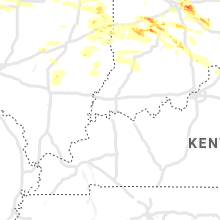
Kentucky
| Local Time | Report Details |
|---|---|
| 11:25 AM EDT | Quarter sized hail reported near Burlington, KY, 13 miles WSW of Cincinnati, OH |
| 11:26 AM EDT | Quarter sized hail reported near Burlington, KY, 13 miles WSW of Cincinnati, OH |
| 11:26 AM EDT | Half Dollar sized hail reported near Burlington, KY, 13 miles WSW of Cincinnati, OH |
| 11:45 AM EDT | Golf Ball sized hail reported near Burlington, KY, 13 miles WSW of Cincinnati, OH |
| 9:18 PM EDT | Numerous trees down on petersburg/belleview roa in boone county KY, 19.5 miles WSW of Cincinnati, OH |
| 9:32 PM EDT | Trees were blown down near exit 171 of i-75 in boone county KY, 18.3 miles SSW of Cincinnati, OH |
| 9:53 PM EDT | Numerous trees reported down across the county. time estimated using radar dat in pendleton county KY, 29.8 miles SSE of Cincinnati, OH |
| 10:15 PM EDT | Numerous trees and power poles down east of maysville along kentucky 8 and 1 in mason county KY, 54 miles SE of Cincinnati, OH |
| 10:26 PM EDT | Gust reported in 1035 pm observation. exact time of gust estimated based on rada in mason county KY, 56.8 miles SE of Cincinnati, OH |
| 10:37 PM EDT | Trees reported down along wooley rd and dudley hollow rd. time estimated from rada in fleming county KY, 52.2 miles NNE of Irvine, KY |
| 10:42 PM EDT | Tree reported down. time estimated from rada in fleming county KY, 53.8 miles NNE of Irvine, KY |
| 10:49 PM EDT | Numerous trees down across roads throughout lewis county.time estimated from radar dat in lewis county KY, 66.3 miles NNE of Irvine, KY |
| 11:06 PM EDT | Trees reported down on n wilson av in rowan county KY, 44.7 miles NE of Irvine, KY |
| 11:34 PM EDT | Trees reported down on laurel rd near elliottvill in rowan county KY, 49.9 miles NE of Irvine, KY |
| 11:36 PM EDT | Trees reported down at the intersection of hwy 437 and hwy 172. time estimated from rada in morgan county KY, 47.8 miles ENE of Irvine, KY |
| 11:45 PM EDT | Large tree blown dow in magoffin county KY, 52.9 miles E of Irvine, KY |
Iowa
| Local Time | Report Details |
|---|---|
| 11:13 AM CDT | Ping Pong Ball sized hail reported near Knoxville, IA, 36.8 miles ESE of Des Moines, IA, one and a half inch hail one and a half mile south of red rock dam. via social media. |
| 11:37 AM CDT | Power pole snapped at base and another three-fourths of the way up. time estimated from rada in wayne county IA, 51 miles S of Des Moines, IA |
| 10:05 PM CDT | Golf Ball sized hail reported near Orient, IA, 46.3 miles WSW of Des Moines, IA, trained spotter reported lots of golf ball sized hail. |
| 10:33 PM CDT | Half Dollar sized hail reported near Lucas, IA, 28.9 miles SSE of Des Moines, IA |
| 10:39 PM CDT | Tea Cup sized hail reported near Lorimor, IA, 39.2 miles SW of Des Moines, IA, via pictures on social media. time estimated from radar. |
| 10:55 PM CDT | Hen Egg sized hail reported near Chariton, IA, 42.4 miles SSE of Des Moines, IA, via social media/broadcast media. |
| 10:55 PM CDT | Quarter sized hail reported near Chariton, IA, 42 miles SSE of Des Moines, IA, lucas county sheriffs office reported quarter sized hail at the office. |
| 10:55 PM CDT | Morton building blew onto ia 5 at the intersection of ia 92. time estimated from rada in marion county IA, 24.8 miles SE of Des Moines, IA |
| 10:55 PM CDT | Quarter sized hail reported near Chariton, IA, 42.6 miles SSE of Des Moines, IA |
| 10:55 PM CDT | Quarter sized hail reported near Chariton, IA, 42.4 miles SSE of Des Moines, IA, lucas county sheriffs office reported quarter sized hail at the office. |
| 11:06 PM CDT | Half Dollar sized hail reported near Knoxville, IA, 32.6 miles SE of Des Moines, IA, public report via media on social media. |
| 11:07 PM CDT | Tennis Ball sized hail reported near Russell, IA, 52.9 miles SSE of Des Moines, IA, mostly quarter to golf ball sized hail with sporadic tennis ball sized hail. via social media/broadcast media. time estimated from radar. |
| 11:08 PM CDT | Quarter sized hail reported near Indianola, IA, 15.3 miles S of Des Moines, IA |
| 11:09 PM CDT | Hen Egg sized hail reported near Knoxville, IA, 33.9 miles ESE of Des Moines, IA, via social media/broadcast media. time estimated from radar. |
| 11:10 PM CDT | Quarter sized hail reported near Osceola, IA, 37.3 miles SSW of Des Moines, IA |
| 11:13 PM CDT | Ping Pong Ball sized hail reported near Knoxville, IA, 36.8 miles ESE of Des Moines, IA, corrects previous hail report from 4 wnw harvey. one and a half inch hail one and a half mile south of red rock dam. via social media. |
| 11:27 PM CDT | Golf Ball sized hail reported near Oakland, IA, 28.3 miles E of Omaha, NE, downtown oakland... ia. |
| 11:30 PM CDT | Golf Ball sized hail reported near Melrose, IA, 57.7 miles SSE of Des Moines, IA, report from mping: golf ball (1.75 in.). |
| 11:31 PM CDT | Report from mping: 1-inch tree limbs broken; shingles blown of in appanoose county IA, 57.7 miles SSE of Des Moines, IA |
| 11:32 PM CDT | Half Dollar sized hail reported near Atlantic, IA, 50 miles ENE of Omaha, NE, quarter to half dollar sized hail at kjan studios. |
| 11:33 PM CDT | Grapefruit sized hail reported near Bridgewater, IA, 59.6 miles WSW of Des Moines, IA, irregular shaped hail; some up to 4 inches in diameter. delayed report. |
| 11:35 PM CDT | Tennis Ball sized hail reported near Griswold, IA, 33.4 miles E of Omaha, NE, social media post of hail ranging from quarter to tennis ball sized. |
| 11:37 PM CDT | Corrects previous tstm wnd dmg report from 2 e humeston. power pole snapped at base and another three-fourths of the way up. time estimated from rada in wayne county IA, 51 miles S of Des Moines, IA |
| 11:56 PM CDT | Blakesburg fire department reporting heavy tree damage and some damage to homes as in soffits tore of in wapello county IA, 61 miles NW of Kahoka, MO |
| 12:00 AM CDT | Hen Egg sized hail reported near Elliott, IA, 46.5 miles E of Omaha, NE, emergency manager reports hail ranging from the sized of ping pongs to golf balls. a few larger than golf ball sized stones were also noted. |
| 12:17 AM CDT | Ping Pong Ball sized hail reported near Keota, IA, 40.7 miles SSW of Cedar Rapids, IA, report and picture via social media. |
Nebraska
| Local Time | Report Details |
|---|---|
| 12:50 PM MDT | Half Dollar sized hail reported near Harrison, NE, 58.2 miles N of Scottsbluff, NE |
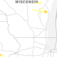
Minnesota
| Local Time | Report Details |
|---|---|
| 8:00 PM CDT | Quarter sized hail reported near Cass Lake, MN, 15 miles E of Bemidji, MN, photo recieved of 1 inch hail 15 miles east of bemidji. |
| 8:05 PM CDT | Quarter sized hail reported near Pennington, MN, 19.6 miles ENE of Bemidji, MN, 1 inch hail reported via webcamera near pimushe resort. |
Wyoming
| Local Time | Report Details |
|---|---|
| 7:45 PM MDT | Ping Pong Ball sized hail reported near Cheyenne, WY, 40.1 miles ESE of Laramie, WY, facebook post. vandehei and i-25. |
| 7:50 PM MDT | Quarter sized hail reported near Cheyenne, WY, 42.1 miles ESE of Laramie, WY |
| 7:55 PM MDT | Ping Pong Ball sized hail reported near Cheyenne, WY, 42.1 miles E of Laramie, WY, quarter to ping pong ball hail at ranchettes. |
| 7:58 PM MDT | Quarter sized hail reported near Cheyenne, WY, 46.2 miles ESE of Laramie, WY, nickel to quarter size hail at converse and lincolnway. |
| 7:58 PM MDT | Quarter sized hail reported near Cheyenne, WY, 41.6 miles ESE of Laramie, WY |
| 7:59 PM MDT | Half Dollar sized hail reported near Cheyenne, WY, 43.1 miles ESE of Laramie, WY, quarter and half dollar hail. |
| 8:00 PM MDT | Half Dollar sized hail reported near Cheyenne, WY, 44 miles ESE of Laramie, WY |
| 8:00 PM MDT | Ping Pong Ball sized hail reported near Cheyenne, WY, 45.5 miles ESE of Laramie, WY, half dollar to ping pong ball hail. |
| 8:00 PM MDT | Half Dollar sized hail reported near Cheyenne, WY, 46.6 miles E of Laramie, WY |
Illinois
| Local Time | Report Details |
|---|---|
| 11:00 PM CDT | 2 large tree limbs blown dow in warren county IL, 57.4 miles WNW of Peoria, IL |
| 11:05 PM CDT | 2 large tree limbs blown dow in warren county IL, 57.4 miles WNW of Peoria, IL |
| 11:29 PM CDT | Storm damage reported in knox county IL, 47.3 miles WNW of Peoria, IL |
| 11:40 PM CDT | Delayed report. tree and powerline damage. power outages in town. time estimated from rada in knox county IL, 43.3 miles W of Peoria, IL |
| 11:40 PM CDT | Report of several trees snapped... a heavily damaged barn... and estimated wind speeds of 80-90 mph wind in fulton county IL, 41.6 miles W of Peoria, IL |
| 11:50 PM CDT | Downed power lines and trees snapped on route 4 in knox county IL, 44.3 miles WNW of Peoria, IL |
| 11:50 PM CDT | Report of numerous trees snapped... grain elevators severely damaged... and powerlines blown down. estimated 80 mph winds based on damag in fulton county IL, 32.7 miles W of Peoria, IL |
| 11:52 PM CDT | Report of farm equipment buildings damaged and powerlines blown into fiel in fulton county IL, 31.6 miles W of Peoria, IL |
| 12:00 AM CDT | Trees down. time estimated by rada in fulton county IL, 30.4 miles W of Peoria, IL |
| 12:06 AM CDT | Power line and power poles broken of in fulton county IL, 27.3 miles WSW of Peoria, IL |
| 12:10 AM CDT | Lots of trees down on north side of canton. report relayed by broadcast media. time estimated by rada in fulton county IL, 25.5 miles WSW of Peoria, IL |
| 12:10 AM CDT | Lots of trees down on north side of canton. report relayed by broadcast media. time estimated by rada in fulton county IL, 25.5 miles WSW of Peoria, IL |
| 12:10 AM CDT | Roof and siding damage. time estimated by rada in fulton county IL, 26.4 miles WSW of Peoria, IL |
| 12:45 AM CDT | Report relayed by emergency manage in tazewell county IL, 14.5 miles SSW of Peoria, IL |
| 12:50 AM CDT | Trees dow in tazewell county IL, 15.1 miles SSW of Peoria, IL |
| 12:58 AM CDT | Corrects previous tstm wnd gst report from tremont. measured at eo in tazewell county IL, 12.3 miles SSE of Peoria, IL |
| 12:58 AM CDT | Corrects previous tstm wnd gst report from tremont. measured at eo in tazewell county IL, 12.3 miles SSE of Peoria, IL |
| 12:58 AM CDT | Report of a large tree down on car in tazewell county IL, 8.9 miles SSW of Peoria, IL |
| 1:02 AM CDT | Storm damage reported in tazewell county IL, 10.2 miles SE of Peoria, IL |
| 1:09 AM CDT | Storm damage reported in tazewell county IL, 16.4 miles SE of Peoria, IL |
| 1:11 AM CDT | Report from mping: 1-inch tree limbs broken; shingles blown of in tazewell county IL, 10.6 miles S of Peoria, IL |
| 3:16 AM CDT | Tree reported down in road and on power line in vermilion county IL, 48.3 miles NE of Mattoon, IL |
| 3:38 AM CDT | Large tree down in tow in champaign county IL, 40.6 miles NNE of Mattoon, IL |
Connect with Interactive Hail Maps