

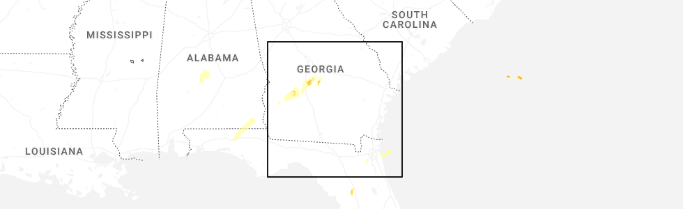
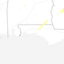
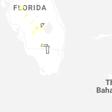
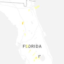
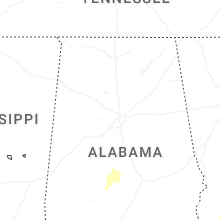
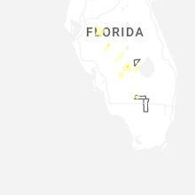
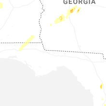
Hail Map for Saturday, May 10, 2025
Number of Impacted Households on 5/10/2025
0
Impacted by 1" or Larger Hail
0
Impacted by 1.75" or Larger Hail
0
Impacted by 2.5" or Larger Hail
Square Miles of Populated Area Impacted on 5/10/2025
0
Impacted by 1" or Larger Hail
0
Impacted by 1.75" or Larger Hail
0
Impacted by 2.5" or Larger Hail
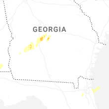
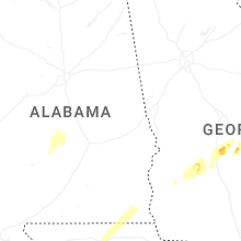
Cities Most Affected by Hail Storms of 5/10/2025
| Hail Size | Demographics of Zip Codes Affected | ||||||
|---|---|---|---|---|---|---|---|
| City | Count | Average | Largest | Pop Density | House Value | Income | Age |
Hail and Wind Damage Spotted on 5/10/2025
Filter by Report Type:Hail ReportsWind Reports
Florida
| Local Time | Report Details |
|---|---|
| 7:20 AM CDT | Weatherstem station 0325w 5.4 e oriole beach (woodlawn beach middle school) gusted to 62mp in santa rosa county FL, 38.8 miles W of Miramar Beach, FL |
| 9:15 AM EDT | Photo via social media of a large branch down in italia. time estimated via rada in nassau county FL, 20.2 miles N of Jacksonville, FL |
| 9:40 AM EDT | Photo via social media of a large branch down near smullian trail near san jose. time estimated via rada in duval county FL, 6.5 miles SSE of Jacksonville, FL |
| 10:15 AM CDT | Numerous trees and powerlines reported down on us-331 south of i-1 in walton county FL, 24.9 miles NE of Miramar Beach, FL |
| 10:30 AM CDT | Numerous trees and powerlines reported down near argyl in walton county FL, 30.5 miles NE of Miramar Beach, FL |
| 3:10 PM EDT | Quarter sized hail reported near Palmdale, FL, 61.9 miles NNE of Naples, FL, fisheating creek campsite reported quarter size hail from a thunderstorm. |
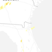
Georgia
| Local Time | Report Details |
|---|---|
| 10:53 AM EDT | Chatham county emergency management reported several trees and large limbs down on burnside islan in chatham county GA, 10.4 miles S of Savannah, GA |
| 12:30 PM EDT | Chatham county emergency management reported several trees and large limbs down on burnside islan in chatham county GA, 10.4 miles S of Savannah, GA |
| 2:36 PM EDT | Several trees and power lines reported down in early count in early county GA, 82 miles NNW of Tallahassee, FL |
| 3:28 PM EDT | Several trees and a powerline were reported down in shellma in randolph county GA, 77.6 miles SE of Auburn, AL |
Alabama
| Local Time | Report Details |
|---|---|
| 11:36 AM CDT | Trees reported down on s cr in geneva county AL, 64.1 miles NE of Miramar Beach, FL |
| 11:42 AM CDT | Trees reported down on cr 9 in geneva county AL, 65.3 miles NE of Miramar Beach, FL |
| 12:20 PM CDT | Power lines reported down in dotha in houston county AL, 82 miles NE of Miramar Beach, FL |
| 12:30 PM CDT | Trees reported down on hopkins r in houston county AL, 78.9 miles NW of Tallahassee, FL |
| 12:42 PM CDT | Trees reported down at cr22 and cr1 in henry county AL, 85.2 miles NW of Tallahassee, FL |
| 12:42 PM CDT | Trees reported down at cr22 and cr2 in henry county AL, 84.4 miles NW of Tallahassee, FL |
| 1:18 PM CDT | Trees reported down at cr431 and cr1 in henry county AL, 71.1 miles S of Auburn, AL |
| 5:30 PM CDT | Quarter sized hail reported near Selma, AL, 40.7 miles NE of Camden, AL, picture on social media of approx 1 inch hail in burnsville. time estimated by radar. |
Idaho
| Local Time | Report Details |
|---|---|
| 2:50 PM MDT | Storm damage reported in custer county ID, 49.5 miles SSW of Salmon, ID |
| 3:20 PM MDT | Mesonet station rwm inl radioactive waste mgm in butte county ID, 50.7 miles W of Idaho Falls, ID |
| 3:26 PM MDT | Large power outage across the richfield are in lincoln county ID, 39.2 miles NNE of Twin Falls, ID |
| 3:35 PM MDT | Lemhi county sheriffs office reports downed tree across a powerline causing 1412 customers to lose powe in lemhi county ID, 11.4 miles SSW of Salmon, ID |
| 3:45 PM MDT | Mesonet station tab 3 w tabe in bingham county ID, 34.7 miles WSW of Idaho Falls, ID |
| 3:50 PM MDT | Mesonet station dea dead man canyo in butte county ID, 51.9 miles W of Idaho Falls, ID |
| 3:55 PM MDT | Mesonet station bas base of howe pea in butte county ID, 50.3 miles WNW of Idaho Falls, ID |
| 4:25 PM MDT | Mesonet station lof inl specific manufacturin in butte county ID, 42.8 miles NW of Idaho Falls, ID |
| 4:25 PM MDT | Mesonet station san 12 e how in butte county ID, 41.1 miles WNW of Idaho Falls, ID |
| 4:41 PM MDT | Large power outage near and just southeast of mud lake with a nearby thunderstorm wind gust measured at 57 mph measured 9 minutes late in jefferson county ID, 27.7 miles NW of Idaho Falls, ID |
| 4:50 PM MDT | Mesonet station nrf inl naval reactors facilit in butte county ID, 44.9 miles WNW of Idaho Falls, ID |
| 5:00 PM MDT | Mesonet station itde3 d6 camas i-1 in jefferson county ID, 37 miles NNW of Idaho Falls, ID |
| 5:10 PM MDT | Mesonet station lof inl specific manufacturin in butte county ID, 42.8 miles NW of Idaho Falls, ID |
| 5:30 PM MDT | Mesonet station mon 6 n montevie in jefferson county ID, 44.2 miles NW of Idaho Falls, ID |
| 5:50 PM MDT | Mesonet station pc371 medicine lodg in clark county ID, 61.3 miles NNW of Idaho Falls, ID |
| 6:30 PM MDT | Mesonet station cr in butte county ID, 75.5 miles W of Idaho Falls, ID |
| 7:00 PM MDT | Measured near the intersection of n 1100 w and w 500 in bingham county ID, 28.5 miles WSW of Idaho Falls, ID |
| 7:05 PM MDT | Thunderstorm winds resulted in power outages just northwest of minidok in minidoka county ID, 48.4 miles ENE of Twin Falls, ID |
| 8:00 PM MDT | Mesonet station 3699 d6 inl puzzle us-20/us-2 in butte county ID, 42.6 miles W of Idaho Falls, ID |
| 8:10 PM MDT | Reported via social media. measured near the intersection of e 1300 n and n 3300 e. no hail or damage reporte in fremont county ID, 48.2 miles NE of Idaho Falls, ID |
| 8:20 PM MDT | Mesonet station sum big southern butt in butte county ID, 49.6 miles W of Idaho Falls, ID |
| 8:20 PM MDT | Mesonet station crii1 cotton ridg in cassia county ID, 30 miles SSE of Twin Falls, ID |
| 8:40 PM MDT | Mesonet station los lost river rest are in butte county ID, 48.8 miles W of Idaho Falls, ID |
| 8:40 PM MDT | Mesonet station 690 inl central facilitie in butte county ID, 45.7 miles W of Idaho Falls, ID |
| 8:45 PM MDT | Mesonet station gri inl intec/grid in butte county ID, 45.6 miles W of Idaho Falls, ID |
| 8:45 PM MDT | Mesonet station tra inl reactor tech comple in butte county ID, 47 miles W of Idaho Falls, ID |
| 8:45 PM MDT | Mesonet station 3699 d6 inl puzzle us-20/us-2 in butte county ID, 42.6 miles W of Idaho Falls, ID |
| 9:19 PM MDT | Power outages across the dietrich area. public reports of strong wind in lincoln county ID, 27.2 miles NNE of Twin Falls, ID |
| 9:40 PM MDT | Mesonet station 690 inl central facilitie in butte county ID, 45.7 miles W of Idaho Falls, ID |
| 9:45 PM MDT | Mesonet station ro in jefferson county ID, 29.1 miles WNW of Idaho Falls, ID |
| 10:15 PM MDT | Mesonet station 3021 d6 tom cat summit us-2 in butte county ID, 72.7 miles NE of Twin Falls, ID |
| 10:25 PM MDT | Mesonet station cr in butte county ID, 75.5 miles W of Idaho Falls, ID |
| 10:55 PM MDT | Mesonet station bas base of howe pea in butte county ID, 50.3 miles WNW of Idaho Falls, ID |
| 11:30 PM MDT | Mesonet station pc374 reno gulc in clark county ID, 51.3 miles NW of Idaho Falls, ID |
| 11:50 PM MDT | Mesonet station tt636 s-c portable no. in butte county ID, 64.5 miles WNW of Idaho Falls, ID |
Montana
| Local Time | Report Details |
|---|---|
| 3:17 PM MDT | 63 mph wind gust at ambient weather station on nw side of great fall in cascade county MT, 1.7 miles NNW of Great Falls, MT |
| 3:20 PM MDT | 65 mph gust at ambient weather station on west side of great fall in cascade county MT, 1.8 miles WNW of Great Falls, MT |
| 3:35 PM MDT | Asos station khln helena airpor in lewis and clark county MT, 70.3 miles SSW of Great Falls, MT |
| 3:51 PM MDT | 61 mph gust at helena airpor in lewis and clark county MT, 70.5 miles SSW of Great Falls, MT |
| 4:35 PM MDT | Mesonet station ginm8 ginger raws. time estimated using radar given the station reports once per hou in broadwater county MT, 52.3 miles NNW of Bozeman, MT |
| 5:00 PM MDT | Mesonet station mtm83 toston sw in broadwater county MT, 38.5 miles NW of Bozeman, MT |
| 5:00 PM MDT | Montana mesonet station big sandy se (acebsase in chouteau county MT, 39.9 miles SSW of Havre, MT |
| 5:15 PM MDT | Mt dot sensor east of denton (mtden) gusted to 58 mp in fergus county MT, 69.8 miles ESE of Great Falls, MT |
| 5:22 PM MDT | Ambient weather station dbr hq measured a 63 mph gus in blaine county MT, 20.1 miles SSE of Havre, MT |
| 5:41 PM MDT | Ambient sensor hilltop0 measured a 66 mph gus in fergus county MT, 77.6 miles S of Havre, MT |
| 5:50 PM MDT | Montana mesonet station woodhawk (acewinif) measured a 60 mph gus in fergus county MT, 60.9 miles SSE of Havre, MT |
| 6:58 PM MDT | Mesonet station jpkm8 judith peak raws. time of gust estimated given station reports once per hou in fergus county MT, 94.4 miles SSE of Havre, MT |
| 7:00 PM MDT | Montana mesonet station forestgrove n (acefores in fergus county MT, 95.7 miles NNW of Billings, MT |
| 7:00 PM MDT | Malta south mt do in phillips county MT, 75 miles ESE of Havre, MT |
| 7:15 PM MDT | Awos station k1om osca in fergus county MT, 91.2 miles SSE of Havre, MT |
| 7:15 PM MDT | Loring sw (hydromet) in north-central phillips count in phillips county MT, 69.6 miles NW of Glasgow, MT |
| 7:27 PM MDT | Asos station khvr havre airpor in hill county MT, 4.5 miles W of Havre, MT |
| 7:30 PM MDT | Mt dot sensor bohemian corner (mtboh in fergus county MT, 92.4 miles SSE of Havre, MT |
| 7:50 PM MDT | Saco s (hydromet) in eastern phillips count in phillips county MT, 35.4 miles W of Glasgow, MT |
| 8:05 PM MDT | Mosby nw (hydromet) in central petroleum count in petroleum county MT, 90.2 miles NNE of Billings, MT |
| 10:45 PM MDT | Asos station kggw glasgow airport (asos in valley county MT, 1.9 miles NNE of Glasgow, MT |
Nevada
| Local Time | Report Details |
|---|---|
| 6:46 PM PDT | Peak outflow gust at mesonet station up983 1.4 w mill city (upr in pershing county NV, 27.8 miles SW of Winnemucca, NV |
Connect with Interactive Hail Maps