

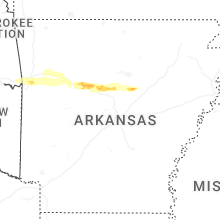
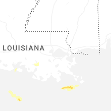
Hail Map for Wednesday, May 7, 2025

Number of Impacted Households on 5/7/2025
0
Impacted by 1" or Larger Hail
0
Impacted by 1.75" or Larger Hail
0
Impacted by 2.5" or Larger Hail
Square Miles of Populated Area Impacted on 5/7/2025
0
Impacted by 1" or Larger Hail
0
Impacted by 1.75" or Larger Hail
0
Impacted by 2.5" or Larger Hail

Cities Most Affected by Hail Storms of 5/7/2025
| Hail Size | Demographics of Zip Codes Affected | ||||||
|---|---|---|---|---|---|---|---|
| City | Count | Average | Largest | Pop Density | House Value | Income | Age |
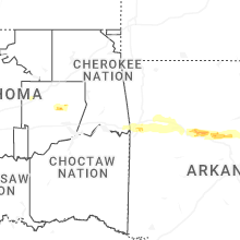
| Atkins, AR | 1 | 1.75 | 1.75 | 54 | $56k | $27.3k | 39.6 |
| Mount Vernon, AR | 1 | 1.75 | 1.75 | 22 | $58k | $29.2k | 40.1 |
| Springfield, AR | 1 | 1.75 | 1.75 | 27 | $44k | $33.0k | 41.5 |
| Alma, AR | 1 | 1.75 | 1.75 | 144 | $81k | $33.9k | 36.7 |
Hail and Wind Damage Spotted on 5/7/2025
Filter by Report Type:Hail ReportsWind Reports
Louisiana
| Local Time | Report Details |
|---|---|
| 9:12 AM CDT | Broadcast media reports wind damage including a bent traffic light pole and downed powerline in jefferson county LA, 4.6 miles SSW of New Orleans, LA |
| 9:12 AM CDT | Broadcast media reports downed power lines on avenue d in marrer in jefferson county LA, 3.9 miles SSW of New Orleans, LA |
| 9:20 AM CDT | Broadcast media reports tree downed on rue michelle in algiers. time estimated by rada in orleans county LA, 5.2 miles ESE of New Orleans, LA |
| 9:20 AM CDT | Awos station knbg belle chasse reports wind gust of 51 knot in plaquemines county LA, 9.8 miles SSE of New Orleans, LA |
| 9:21 AM CDT | Emergency manager reports trees and tree branches down on several streets in belle chasse. time estimated by rada in plaquemines county LA, 8.3 miles SE of New Orleans, LA |
| 9:36 AM CDT | Asos station knew new orleans lakefront airport reports wind gust of 50 knot in orleans county LA, 6.6 miles NNE of New Orleans, LA |
| 10:39 AM CDT | Broadcast media reports large tree fallen on st ferdinand st behind george washington carver high schoo in orleans county LA, 3.9 miles NE of New Orleans, LA |
Iowa
| Local Time | Report Details |
|---|---|
| 5:10 PM CDT | Mesonet station rcdi4 cedar rapids i-38 in linn county IA, 0.3 miles NE of Cedar Rapids, IA |
Arkansas
| Local Time | Report Details |
|---|---|
| 9:32 PM CDT | Golf Ball sized hail reported near Alma, AR, 11.2 miles ENE of Fort Smith, AR |
| 10:43 PM CDT | Tree fell onto a powerlin in logan county AR, 49.8 miles E of Fort Smith, AR |
| 11:29 PM CDT | Quarter sized hail reported near Russellville, AR, 59.4 miles NW of Little Rock, AR |
| 11:45 PM CDT | Golf Ball sized hail reported near Atkins, AR, 54 miles NW of Little Rock, AR |
| 12:25 AM CDT | Golf Ball sized hail reported near Springfield, AR, 39.4 miles NNW of Little Rock, AR |
| 12:41 AM CDT | Quarter sized hail reported near Greenbrier, AR, 35.9 miles N of Little Rock, AR |
| 1:09 AM CDT | Golf Ball sized hail reported near Mount Vernon, AR, 34.3 miles NNE of Little Rock, AR |
| 1:10 AM CDT | Half Dollar sized hail reported near Mount Vernon, AR, 37.7 miles NNE of Little Rock, AR |
| 1:12 AM CDT | Half Dollar sized hail reported near Rose Bud, AR, 38.3 miles NNE of Little Rock, AR |
Connect with Interactive Hail Maps