

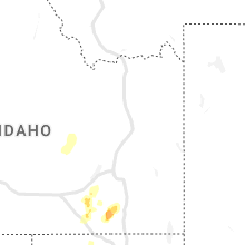
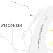
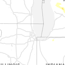
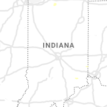
Hail Map for Wednesday, September 21, 2022

Number of Impacted Households on 9/21/2022
0
Impacted by 1" or Larger Hail
0
Impacted by 1.75" or Larger Hail
0
Impacted by 2.5" or Larger Hail
Square Miles of Populated Area Impacted on 9/21/2022
0
Impacted by 1" or Larger Hail
0
Impacted by 1.75" or Larger Hail
0
Impacted by 2.5" or Larger Hail


Cities Most Affected by Hail Storms of 9/21/2022
| Hail Size | Demographics of Zip Codes Affected | ||||||
|---|---|---|---|---|---|---|---|
| City | Count | Average | Largest | Pop Density | House Value | Income | Age |
| Mason, MI | 1 | 2.00 | 2.00 | 167 | $127k | $51.7k | 41.0 |
| Gladwin, MI | 1 | 1.75 | 1.75 | 54 | $87k | $31.8k | 49.0 |
| Sand Lake, MI | 1 | 1.75 | 1.75 | 111 | $106k | $46.9k | 38.3 |
Hail and Wind Damage Spotted on 9/21/2022
Filter by Report Type:Hail ReportsWind Reports
Michigan
| Local Time | Report Details |
|---|---|
| 8:00 AM EDT | Ping Pong Ball sized hail reported near Harrison, MI, 64.6 miles SE of Traverse City, MI, public reports of hail estimated near ping-pong ball sized around 8:00 am. |
| 8:06 AM EDT | Golf Ball sized hail reported near Gladwin, MI, 70.6 miles SE of Traverse City, MI |
| 8:20 AM EDT | Quarter sized hail reported near Bear Lake, MI, 35.3 miles SW of Traverse City, MI, bear lake area. report relayed by local broadcast media. |
| 8:30 AM EDT | Ping Pong Ball sized hail reported near Kaleva, MI, 33.2 miles SW of Traverse City, MI, report relayed by local broadcast media. |
| 8:45 AM EDT | Quarter sized hail reported near Sand Lake, MI, 22.6 miles N of Grand Rapids, MI, 1 inch hail measured around 845 am near 22 mile road and simmons ave. |
| 8:47 AM EDT | Golf Ball sized hail reported near Sand Lake, MI, 23.3 miles NNE of Grand Rapids, MI |
| 8:53 AM EDT | Half Dollar sized hail reported near Sand Lake, MI, 23.8 miles NNE of Grand Rapids, MI, report from mping: half dollar (1.25 in.). |
| 9:00 AM EDT | Half Dollar sized hail reported near Standish, MI, 68.3 miles NNW of Flint, MI, half dollar sized hail called in from public source. |
| 9:20 AM EDT | At saginaw bay light in lhz422 county MI, 55.2 miles N of Flint, MI |
| 9:26 AM EDT | Multple tree limbs and power lines down across the count in bay county MI, 46.1 miles NNW of Flint, MI |
| 9:26 AM EDT | Trees over the road on lincoln road east of baldwin r in gratiot county MI, 50.1 miles WNW of Flint, MI |
| 9:59 AM EDT | Numerous trees and power lines dow in tuscola county MI, 25.4 miles NNE of Flint, MI |
| 10:38 AM EDT | Hen Egg sized hail reported near Mason, MI, 48.1 miles SW of Flint, MI, mping report. time estimated from radar. |
| 11:23 AM EDT | Quarter sized hail reported near Detroit, MI, 48.8 miles SE of Flint, MI |
Idaho
| Local Time | Report Details |
|---|---|
| 12:08 PM MDT | Storm damage reported in twin falls county ID, 4.6 miles S of Twin Falls, ID |
| 12:42 PM MDT | Mesonet station pcki1 pole cree in owyhee county ID, 75.5 miles WSW of Twin Falls, ID |
| 1:54 PM MDT | Itd timmerman hil in blaine county ID, 53.9 miles N of Twin Falls, ID |
| 2:44 PM MDT | Ohio gulch raw in blaine county ID, 76.7 miles N of Twin Falls, ID |
| 4:20 PM MDT | Noaa arl frd dead man canyo in butte county ID, 52.9 miles WNW of Idaho Falls, ID |
| 4:30 PM MDT | Itd inl puzzl in butte county ID, 41.6 miles W of Idaho Falls, ID |
| 5:00 PM MDT | Pilot gold i in oneida county ID, 85 miles ESE of Twin Falls, ID |
| 6:19 PM MDT | Raft river raw in cassia county ID, 64.3 miles E of Twin Falls, ID |
Utah
| Local Time | Report Details |
|---|---|
| 1:45 PM MDT | Measured from dpg1 in tooele county UT, 68.8 miles WSW of Salt Lake City, UT |
| 6:44 PM MDT | Measured from groome site... ur30 in box elder county UT, 87.6 miles WNW of Salt Lake City, UT |
Indiana
| Local Time | Report Details |
|---|---|
| 5:25 PM EDT | Late report with further details on previous report of wind damage. 6 homes damaged from falling trees. one building on the southwest side of rushville with partial roo in rush county IN, 38.8 miles ESE of Indianapolis, IN |
| 5:25 PM EDT | Trees and powerlines down in rushville and to the south and eas in rush county IN, 40.1 miles ESE of Indianapolis, IN |
| 5:50 PM EDT | Trees and powerlines down in central decatur count in decatur county IN, 46 miles SE of Indianapolis, IN |
| 7:14 PM EDT | Numerous trees down near south old michigan road and 100 south. time estimated from rada in ripley county IN, 45.6 miles W of Cincinnati, OH |
| 7:17 PM EDT | Power pole down on us 50 near quickpix. time estimated from rada in ripley county IN, 40.7 miles W of Cincinnati, OH |
| 7:44 PM EDT | Trees down on salem ridge road. time estimated from rada in ohio county IN, 24.3 miles WSW of Cincinnati, OH |
| 7:45 PM EDT | Trees down on state route 56. time estimated from rada in ohio county IN, 21.1 miles WSW of Cincinnati, OH |
Arizona
| Local Time | Report Details |
|---|---|
| 3:55 PM MST | Several downed palo verde trees due to win in pima county AZ, 21.4 miles NW of Tucson, AZ |
| 4:39 PM MST | News article on twitter from kold about downed powerlines... and closing the road in pima county AZ, 19.6 miles NW of Tucson, AZ |
Ohio
| Local Time | Report Details |
|---|---|
| 7:03 PM EDT | Tree reported down on columbia road. time estimated from rada in butler county OH, 20.1 miles NNW of Cincinnati, OH |
| 7:04 PM EDT | Tree reported down on 2nd street. time estimated from rada in butler county OH, 20.5 miles N of Cincinnati, OH |
| 9:40 PM EDT | Large limb and power line down in guernsey county OH, 76.7 miles E of Columbus, OH |
Kentucky
| Local Time | Report Details |
|---|---|
| 8:10 PM EDT | Numerous trees down between union... walton... and veron in boone county KY, 17.1 miles SSW of Cincinnati, OH |
Illinois
| Local Time | Report Details |
|---|---|
| 8:24 PM CDT | The back corner of a 2 story apartment building was damaged including a portion of the roof remove in st. clair county IL, 21.2 miles SE of Saint Louis, MO |
| 8:24 PM CDT | Two trees reported down... one on north main street and another at kester street and railroad stree in st. clair county IL, 20.8 miles SE of Saint Louis, MO |
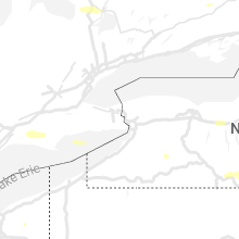
New York
| Local Time | Report Details |
|---|---|
| 1:10 AM EDT | Multiple trees down along state route 19 in fillmor in allegany county NY, 48.1 miles SE of Buffalo, NY |
| 1:13 AM EDT | Trees down in franklinvill in cattaraugus county NY, 43.3 miles SSE of Buffalo, NY |
| 2:03 AM EDT | Trees down in phelp in ontario county NY, 46.7 miles W of Syracuse, NY |
| 2:12 AM EDT | Wires down... causing a power outage on seneca boulevard. time estimated from rada in seneca county NY, 41.9 miles WSW of Syracuse, NY |
Connect with Interactive Hail Maps