

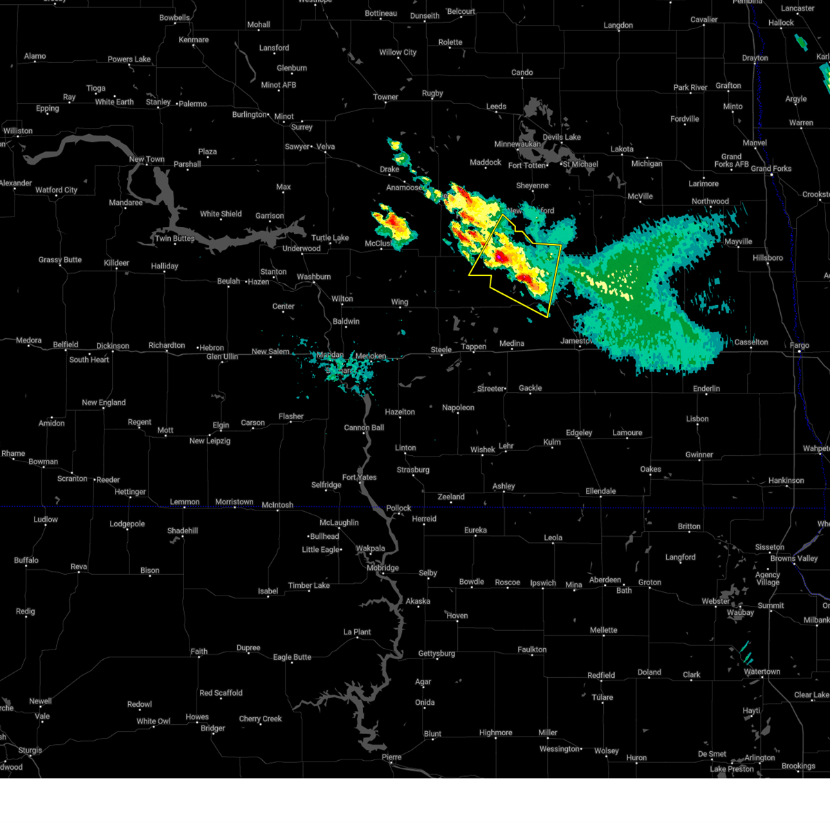
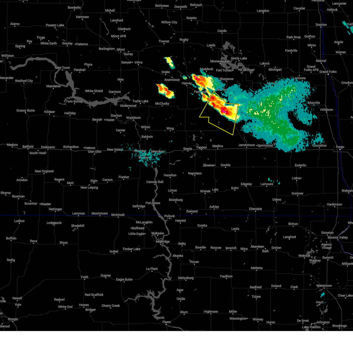
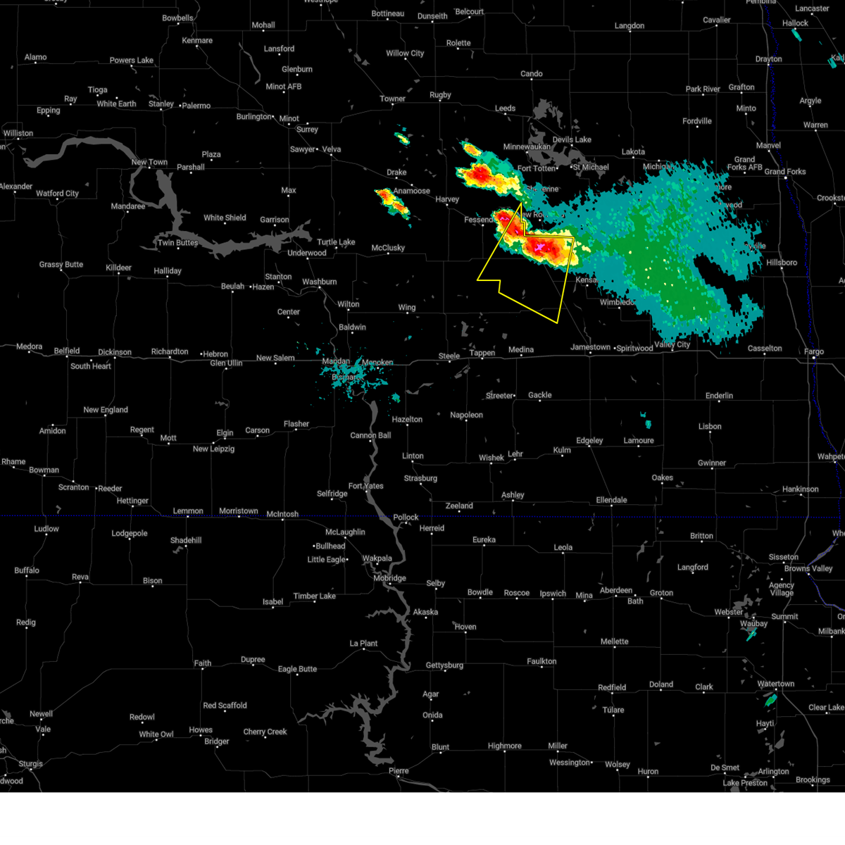
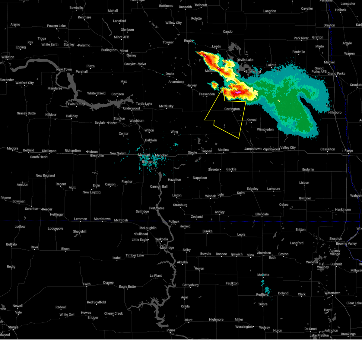
Hail Map for Carrington, ND
The Carrington, ND area has had 14 reports of on-the-ground hail by trained spotters, and has been under severe weather warnings 4 times during the past 12 months. Doppler radar has detected hail at or near Carrington, ND on 37 occasions, including 1 occasion during the past year.
| Name: | Carrington, ND |
| Where Located: | 47.4 miles SSW of Devils Lake, ND |
| Map: | Google Map for Carrington, ND |
| Population: | 2065 |
| Housing Units: | 1057 |
| More Info: | Search Google for Carrington, ND |
1
The Top Recent Hail Date for Carrington, ND is Monday, July 22, 2024 (3rd out of 37)

Hail and Wind Damage Spotted near Carrington, ND
| Date / Time | Report Details |
|---|---|
| 7/22/2024 8:44 PM CDT |
 The storm which prompted the warning has weakened below severe limits, and no longer poses an immediate threat to life or property. therefore, the warning will be allowed to expire. however, small hail and heavy rain are still possible with this thunderstorm. The storm which prompted the warning has weakened below severe limits, and no longer poses an immediate threat to life or property. therefore, the warning will be allowed to expire. however, small hail and heavy rain are still possible with this thunderstorm.
|
| 7/22/2024 8:22 PM CDT |
 At 821 pm cdt, a severe thunderstorm was located near carrington, moving south at 20 mph (radar indicated). Hazards include 60 mph wind gusts and quarter size hail. Hail damage to vehicles is expected. expect wind damage to roofs, siding, and trees. Locations impacted include, carrington, bordulac, cathay, sykeston, melville, edmunds, and heaton. At 821 pm cdt, a severe thunderstorm was located near carrington, moving south at 20 mph (radar indicated). Hazards include 60 mph wind gusts and quarter size hail. Hail damage to vehicles is expected. expect wind damage to roofs, siding, and trees. Locations impacted include, carrington, bordulac, cathay, sykeston, melville, edmunds, and heaton.
|
| 7/22/2024 8:20 PM CDT | Briefly gusted up to 60 mph as the storm came in... along with pea-sized hail and lots of rai in foster county ND, 1.5 miles SSE of Carrington, ND |
| 7/22/2024 8:05 PM CDT |
 At 804 pm cdt, a severe thunderstorm was located near carrington, moving south at 30 mph (radar indicated). Hazards include 60 mph wind gusts and half dollar size hail. Hail damage to vehicles is expected. expect wind damage to roofs, siding, and trees. Locations impacted include, carrington, bordulac, cathay, sykeston, melville, edmunds, heaton, and barlow. At 804 pm cdt, a severe thunderstorm was located near carrington, moving south at 30 mph (radar indicated). Hazards include 60 mph wind gusts and half dollar size hail. Hail damage to vehicles is expected. expect wind damage to roofs, siding, and trees. Locations impacted include, carrington, bordulac, cathay, sykeston, melville, edmunds, heaton, and barlow.
|
| 7/22/2024 7:40 PM CDT |
 Svrbis the national weather service in bismarck has issued a * severe thunderstorm warning for, southeastern wells county in south central north dakota, western foster county in southeastern north dakota, northwestern stutsman county in southeastern north dakota, * until 845 pm cdt. * at 739 pm cdt, a severe thunderstorm was located 5 miles southeast of new rockford, or 12 miles north of carrington, moving southwest at 30 mph (radar indicated). Hazards include 60 mph wind gusts and half dollar size hail. Hail damage to vehicles is expected. Expect wind damage to roofs, siding, and trees. Svrbis the national weather service in bismarck has issued a * severe thunderstorm warning for, southeastern wells county in south central north dakota, western foster county in southeastern north dakota, northwestern stutsman county in southeastern north dakota, * until 845 pm cdt. * at 739 pm cdt, a severe thunderstorm was located 5 miles southeast of new rockford, or 12 miles north of carrington, moving southwest at 30 mph (radar indicated). Hazards include 60 mph wind gusts and half dollar size hail. Hail damage to vehicles is expected. Expect wind damage to roofs, siding, and trees.
|
| 9/4/2023 10:56 PM CDT |
 The severe thunderstorm warning for wells, northeastern kidder, foster and northern stutsman counties will expire at 1100 pm cdt, the storms which prompted the warning have moved out of the area. therefore, the warning will be allowed to expire. The severe thunderstorm warning for wells, northeastern kidder, foster and northern stutsman counties will expire at 1100 pm cdt, the storms which prompted the warning have moved out of the area. therefore, the warning will be allowed to expire.
|
| 9/4/2023 10:42 PM CDT |
 At 1042 pm cdt, severe thunderstorms were located along a line extending from 6 miles southwest of maddock to 5 miles west of fort totten to 11 miles north of grace city to near kensal, moving northeast at 50 mph (radar indicated). Hazards include 60 mph wind gusts and penny size hail. Expect damage to roofs, siding, and trees. these severe storms will be near, mchenry around 1045 pm cdt. glenfield around 1050 pm cdt. other locations impacted by these severe thunderstorms include juanita, manfred, bowdon, wellsburg, barlow, sykeston, chaseley, emrick, bremen and melville. hail threat, radar indicated max hail size, 0. 75 in wind threat, radar indicated max wind gust, 60 mph. At 1042 pm cdt, severe thunderstorms were located along a line extending from 6 miles southwest of maddock to 5 miles west of fort totten to 11 miles north of grace city to near kensal, moving northeast at 50 mph (radar indicated). Hazards include 60 mph wind gusts and penny size hail. Expect damage to roofs, siding, and trees. these severe storms will be near, mchenry around 1045 pm cdt. glenfield around 1050 pm cdt. other locations impacted by these severe thunderstorms include juanita, manfred, bowdon, wellsburg, barlow, sykeston, chaseley, emrick, bremen and melville. hail threat, radar indicated max hail size, 0. 75 in wind threat, radar indicated max wind gust, 60 mph.
|
| 9/4/2023 10:26 PM CDT |
 At 1026 pm cdt, severe thunderstorms were located along a line extending from near harvey to 7 miles southwest of oberon to 5 miles west of grace city to near pingree, moving northeast at 50 mph (radar indicated). Hazards include 60 mph wind gusts and nickel size hail. Expect damage to roofs, siding, and trees. these severe storms will be near, kensal, grace city and pingree around 1030 pm cdt. mchenry around 1040 pm cdt. glenfield and courtenay around 1045 pm cdt. other locations impacted by these severe thunderstorms include juanita, manfred, chase lake, bowdon, wellsburg, barlow, sykeston, chaseley, emrick and bremen. hail threat, radar indicated max hail size, 0. 88 in wind threat, radar indicated max wind gust, 60 mph. At 1026 pm cdt, severe thunderstorms were located along a line extending from near harvey to 7 miles southwest of oberon to 5 miles west of grace city to near pingree, moving northeast at 50 mph (radar indicated). Hazards include 60 mph wind gusts and nickel size hail. Expect damage to roofs, siding, and trees. these severe storms will be near, kensal, grace city and pingree around 1030 pm cdt. mchenry around 1040 pm cdt. glenfield and courtenay around 1045 pm cdt. other locations impacted by these severe thunderstorms include juanita, manfred, chase lake, bowdon, wellsburg, barlow, sykeston, chaseley, emrick and bremen. hail threat, radar indicated max hail size, 0. 88 in wind threat, radar indicated max wind gust, 60 mph.
|
| 9/4/2023 10:09 PM CDT | Private weather station report. winds lasted from 1009-1014 pm cd in foster county ND, 10.2 miles SSE of Carrington, ND |
| 9/4/2023 10:09 PM CDT |
 At 1008 pm cdt, severe thunderstorms were located along a line extending from 5 miles northeast of goodrich to 5 miles east of fessenden to 6 miles south of carrington to 5 miles northwest of cleveland, moving northeast at 45 mph (radar indicated). Hazards include 60 mph wind gusts and penny size hail. Expect damage to roofs, siding, and trees. these severe storms will be near, carrington, fessenden and bordulac around 1015 pm cdt. pingree around 1025 pm cdt. grace city around 1035 pm cdt. kensal around 1045 pm cdt. mchenry around 1105 pm cdt. other locations impacted by these severe thunderstorms include eldridge, juanita, manfred, driscoll, chase lake, windsor, bowdon, wellsburg, barlow and arena. hail threat, radar indicated max hail size, 0. 75 in wind threat, radar indicated max wind gust, 60 mph. At 1008 pm cdt, severe thunderstorms were located along a line extending from 5 miles northeast of goodrich to 5 miles east of fessenden to 6 miles south of carrington to 5 miles northwest of cleveland, moving northeast at 45 mph (radar indicated). Hazards include 60 mph wind gusts and penny size hail. Expect damage to roofs, siding, and trees. these severe storms will be near, carrington, fessenden and bordulac around 1015 pm cdt. pingree around 1025 pm cdt. grace city around 1035 pm cdt. kensal around 1045 pm cdt. mchenry around 1105 pm cdt. other locations impacted by these severe thunderstorms include eldridge, juanita, manfred, driscoll, chase lake, windsor, bowdon, wellsburg, barlow and arena. hail threat, radar indicated max hail size, 0. 75 in wind threat, radar indicated max wind gust, 60 mph.
|
| 9/4/2023 9:53 PM CDT |
 At 952 pm cdt, severe thunderstorms were located along a line extending from near goodrich to 11 miles southwest of cathay to near woodworth to 5 miles southwest of medina, moving northeast at 50 mph (radar indicated). Hazards include 60 mph wind gusts and penny size hail. Expect damage to roofs, siding, and trees. these severe storms will be near, medina and cathay around 1000 pm cdt. carrington and fessenden around 1005 pm cdt. bordulac around 1010 pm cdt. grace city and pingree around 1025 pm cdt. kensal and mchenry around 1045 pm cdt. glenfield around 1100 pm cdt. other locations impacted by these severe thunderstorms include juanita, driscoll, chase lake, windsor, wellsburg, sykeston, chaseley, emrick, bremen and melville. hail threat, radar indicated max hail size, 0. 75 in wind threat, radar indicated max wind gust, 60 mph. At 952 pm cdt, severe thunderstorms were located along a line extending from near goodrich to 11 miles southwest of cathay to near woodworth to 5 miles southwest of medina, moving northeast at 50 mph (radar indicated). Hazards include 60 mph wind gusts and penny size hail. Expect damage to roofs, siding, and trees. these severe storms will be near, medina and cathay around 1000 pm cdt. carrington and fessenden around 1005 pm cdt. bordulac around 1010 pm cdt. grace city and pingree around 1025 pm cdt. kensal and mchenry around 1045 pm cdt. glenfield around 1100 pm cdt. other locations impacted by these severe thunderstorms include juanita, driscoll, chase lake, windsor, wellsburg, sykeston, chaseley, emrick, bremen and melville. hail threat, radar indicated max hail size, 0. 75 in wind threat, radar indicated max wind gust, 60 mph.
|
| 9/4/2023 9:27 PM CDT |
 At 926 pm cdt, severe thunderstorms were located along a line extending from 10 miles north of regan to near tuttle to near tappen to 4 miles north of napoleon, moving northeast at 40 mph (radar indicated). Hazards include 60 mph wind gusts and penny size hail. Expect damage to roofs, siding, and trees. severe thunderstorms will be near, tappen and robinson around 930 pm cdt. pettibone around 940 pm cdt. goodrich and hurdsfield around 945 pm cdt. medina and woodworth around 950 pm cdt. cathay around 1010 pm cdt. fessenden and cleveland around 1015 pm cdt. carrington and pingree around 1020 pm cdt. bordulac around 1025 pm cdt. other locations impacted by these severe thunderstorms include juanita, driscoll, chase lake, windsor, wellsburg, sykeston, chaseley, emrick, bremen and melville. hail threat, radar indicated max hail size, 0. 75 in wind threat, radar indicated max wind gust, 60 mph. At 926 pm cdt, severe thunderstorms were located along a line extending from 10 miles north of regan to near tuttle to near tappen to 4 miles north of napoleon, moving northeast at 40 mph (radar indicated). Hazards include 60 mph wind gusts and penny size hail. Expect damage to roofs, siding, and trees. severe thunderstorms will be near, tappen and robinson around 930 pm cdt. pettibone around 940 pm cdt. goodrich and hurdsfield around 945 pm cdt. medina and woodworth around 950 pm cdt. cathay around 1010 pm cdt. fessenden and cleveland around 1015 pm cdt. carrington and pingree around 1020 pm cdt. bordulac around 1025 pm cdt. other locations impacted by these severe thunderstorms include juanita, driscoll, chase lake, windsor, wellsburg, sykeston, chaseley, emrick, bremen and melville. hail threat, radar indicated max hail size, 0. 75 in wind threat, radar indicated max wind gust, 60 mph.
|
| 7/18/2023 9:09 PM CDT |
 At 909 pm cdt, a severe thunderstorm was located 5 miles southwest of carrington, moving southeast at 25 mph (radar indicated). Hazards include 60 mph wind gusts and quarter size hail. Hail damage to vehicles is expected. expect wind damage to roofs, siding, and trees. locations impacted include, carrington and barlow. hail threat, radar indicated max hail size, 1. 00 in wind threat, radar indicated max wind gust, 60 mph. At 909 pm cdt, a severe thunderstorm was located 5 miles southwest of carrington, moving southeast at 25 mph (radar indicated). Hazards include 60 mph wind gusts and quarter size hail. Hail damage to vehicles is expected. expect wind damage to roofs, siding, and trees. locations impacted include, carrington and barlow. hail threat, radar indicated max hail size, 1. 00 in wind threat, radar indicated max wind gust, 60 mph.
|
| 7/18/2023 8:57 PM CDT |
 At 856 pm cdt, a severe thunderstorm was located 9 miles west of carrington, moving southeast at 30 mph (radar indicated). Hazards include 60 mph wind gusts and quarter size hail. Hail damage to vehicles is expected. expect wind damage to roofs, siding, and trees. locations impacted include, carrington, sykeston and barlow. hail threat, radar indicated max hail size, 1. 00 in wind threat, radar indicated max wind gust, 60 mph. At 856 pm cdt, a severe thunderstorm was located 9 miles west of carrington, moving southeast at 30 mph (radar indicated). Hazards include 60 mph wind gusts and quarter size hail. Hail damage to vehicles is expected. expect wind damage to roofs, siding, and trees. locations impacted include, carrington, sykeston and barlow. hail threat, radar indicated max hail size, 1. 00 in wind threat, radar indicated max wind gust, 60 mph.
|
| 7/18/2023 8:42 PM CDT |
 At 841 pm cdt, a severe thunderstorm was located near cathay, or 16 miles west of carrington, moving southeast at 25 mph (radar indicated). Hazards include ping pong ball size hail and 60 mph wind gusts. People and animals outdoors will be injured. expect hail damage to roofs, siding, windows, and vehicles. expect wind damage to roofs, siding, and trees. this severe thunderstorm will remain over mainly rural areas of southeastern wells and western foster counties, including the following locations, barlow, heaton and sykeston. hail threat, radar indicated max hail size, 1. 50 in wind threat, radar indicated max wind gust, 60 mph. At 841 pm cdt, a severe thunderstorm was located near cathay, or 16 miles west of carrington, moving southeast at 25 mph (radar indicated). Hazards include ping pong ball size hail and 60 mph wind gusts. People and animals outdoors will be injured. expect hail damage to roofs, siding, windows, and vehicles. expect wind damage to roofs, siding, and trees. this severe thunderstorm will remain over mainly rural areas of southeastern wells and western foster counties, including the following locations, barlow, heaton and sykeston. hail threat, radar indicated max hail size, 1. 50 in wind threat, radar indicated max wind gust, 60 mph.
|
| 7/31/2022 1:28 AM CDT |
 At 124 am cdt, a severe thunderstorm was located near grace city, or 15 miles east of carrington, moving east at 45 mph (radar indicated). Hazards include 60 mph wind gusts. Expect damage to roofs, siding, and trees. this severe storm will be near, glenfield, juanita and mchenry around 140 am cdt. other locations impacted by this severe thunderstorm include bordulac. hail threat, radar indicated max hail size, <. 75 in wind threat, observed max wind gust, 60 mph. At 124 am cdt, a severe thunderstorm was located near grace city, or 15 miles east of carrington, moving east at 45 mph (radar indicated). Hazards include 60 mph wind gusts. Expect damage to roofs, siding, and trees. this severe storm will be near, glenfield, juanita and mchenry around 140 am cdt. other locations impacted by this severe thunderstorm include bordulac. hail threat, radar indicated max hail size, <. 75 in wind threat, observed max wind gust, 60 mph.
|
| 7/31/2022 1:04 AM CDT |
 At 102 am cdt, a severe thunderstorm was located near carrington, moving east at 45 mph (radar indicated). Hazards include 60 mph wind gusts and penny size hail. Expect damage to roofs, siding, and trees. this severe thunderstorm will be near, carrington around 105 am cdt bordulac around 115 am cdt. grace city around 125 am cdt. glenfield and mchenry around 140 am cdt. other locations impacted by this severe thunderstorm include juanita, melville and barlow. hail threat, radar indicated max hail size, 0. 75 in wind threat, observed max wind gust, 60 mph. At 102 am cdt, a severe thunderstorm was located near carrington, moving east at 45 mph (radar indicated). Hazards include 60 mph wind gusts and penny size hail. Expect damage to roofs, siding, and trees. this severe thunderstorm will be near, carrington around 105 am cdt bordulac around 115 am cdt. grace city around 125 am cdt. glenfield and mchenry around 140 am cdt. other locations impacted by this severe thunderstorm include juanita, melville and barlow. hail threat, radar indicated max hail size, 0. 75 in wind threat, observed max wind gust, 60 mph.
|
| 7/31/2022 12:55 AM CDT | Carrington airpor in foster county ND, 0.2 miles E of Carrington, ND |
| 6/24/2022 5:38 PM CDT |
 At 538 pm cdt, severe thunderstorms were located along a line extending from 12 miles north of grace city to 6 miles northeast of carrington to 9 miles north of woodworth, moving east at 25 mph (radar indicated). Hazards include 60 mph wind gusts and half dollar size hail. Hail damage to vehicles is expected. expect wind damage to roofs, siding, and trees. locations impacted include, carrington, bordulac, melville and barlow. hail threat, radar indicated max hail size, 1. 25 in wind threat, radar indicated max wind gust, 60 mph. At 538 pm cdt, severe thunderstorms were located along a line extending from 12 miles north of grace city to 6 miles northeast of carrington to 9 miles north of woodworth, moving east at 25 mph (radar indicated). Hazards include 60 mph wind gusts and half dollar size hail. Hail damage to vehicles is expected. expect wind damage to roofs, siding, and trees. locations impacted include, carrington, bordulac, melville and barlow. hail threat, radar indicated max hail size, 1. 25 in wind threat, radar indicated max wind gust, 60 mph.
|
| 6/24/2022 5:28 PM CDT |
 At 528 pm cdt, severe thunderstorms were located along a line extending from 11 miles east of new rockford to 4 miles north of carrington to 9 miles north of woodworth, moving east at 25 mph (radar indicated). Hazards include 60 mph wind gusts and half dollar size hail. Hail damage to vehicles is expected. expect wind damage to roofs, siding, and trees. these severe thunderstorms will remain over mainly rural areas of southeastern wells and western foster counties, including the following locations, melville, barlow and sykeston. hail threat, radar indicated max hail size, 1. 25 in wind threat, radar indicated max wind gust, 60 mph. At 528 pm cdt, severe thunderstorms were located along a line extending from 11 miles east of new rockford to 4 miles north of carrington to 9 miles north of woodworth, moving east at 25 mph (radar indicated). Hazards include 60 mph wind gusts and half dollar size hail. Hail damage to vehicles is expected. expect wind damage to roofs, siding, and trees. these severe thunderstorms will remain over mainly rural areas of southeastern wells and western foster counties, including the following locations, melville, barlow and sykeston. hail threat, radar indicated max hail size, 1. 25 in wind threat, radar indicated max wind gust, 60 mph.
|
| 6/24/2022 5:12 PM CDT |
 At 512 pm cdt, severe thunderstorms were located along a line extending from near sheyenne to 11 miles south of cathay, moving east at 30 mph (radar indicated). Hazards include 60 mph wind gusts and half dollar size hail. Hail damage to vehicles is expected. expect wind damage to roofs, siding, and trees. these severe storms will be near, carrington around 540 pm cdt. bordulac around 555 pm cdt. other locations impacted by these severe thunderstorms include emrick, bremen, melville, heaton, hamberg, barlow and sykeston. hail threat, radar indicated max hail size, 1. 25 in wind threat, radar indicated max wind gust, 60 mph. At 512 pm cdt, severe thunderstorms were located along a line extending from near sheyenne to 11 miles south of cathay, moving east at 30 mph (radar indicated). Hazards include 60 mph wind gusts and half dollar size hail. Hail damage to vehicles is expected. expect wind damage to roofs, siding, and trees. these severe storms will be near, carrington around 540 pm cdt. bordulac around 555 pm cdt. other locations impacted by these severe thunderstorms include emrick, bremen, melville, heaton, hamberg, barlow and sykeston. hail threat, radar indicated max hail size, 1. 25 in wind threat, radar indicated max wind gust, 60 mph.
|
| 6/24/2022 4:52 PM CDT |
 At 452 pm cdt, a severe thunderstorm was located near cathay, or 19 miles west of carrington, moving east at 25 mph (radar indicated). Hazards include 60 mph wind gusts and half dollar size hail. Hail damage to vehicles is expected. expect wind damage to roofs, siding, and trees. this severe thunderstorm will be near, cathay around 505 pm cdt. other locations impacted by this severe thunderstorm include manfred, emrick, bremen, melville, heaton, hamberg, bowdon, barlow and sykeston. hail threat, radar indicated max hail size, 1. 25 in wind threat, radar indicated max wind gust, 60 mph. At 452 pm cdt, a severe thunderstorm was located near cathay, or 19 miles west of carrington, moving east at 25 mph (radar indicated). Hazards include 60 mph wind gusts and half dollar size hail. Hail damage to vehicles is expected. expect wind damage to roofs, siding, and trees. this severe thunderstorm will be near, cathay around 505 pm cdt. other locations impacted by this severe thunderstorm include manfred, emrick, bremen, melville, heaton, hamberg, bowdon, barlow and sykeston. hail threat, radar indicated max hail size, 1. 25 in wind threat, radar indicated max wind gust, 60 mph.
|
| 6/19/2022 10:57 PM CDT |
 The severe thunderstorm warning for southeastern wells and foster counties will expire at 1100 pm cdt, the storms which prompted the warning have moved out of the area. therefore, the warning will be allowed to expire. The severe thunderstorm warning for southeastern wells and foster counties will expire at 1100 pm cdt, the storms which prompted the warning have moved out of the area. therefore, the warning will be allowed to expire.
|
| 6/19/2022 10:45 PM CDT |
 At 1044 pm cdt, severe thunderstorms were located along a line extending from glenfield to 15 miles southeast of hurdsfield, moving north at 55 mph (radar indicated). Hazards include 60 mph wind gusts and quarter size hail. Hail damage to vehicles is expected. expect wind damage to roofs, siding, and trees. locations impacted include, carrington, fessenden, glenfield, bordulac, grace city, mchenry, cathay, sykeston, melville, juanita, barlow, emrick and heaton. hail threat, radar indicated max hail size, 1. 00 in wind threat, radar indicated max wind gust, 60 mph. At 1044 pm cdt, severe thunderstorms were located along a line extending from glenfield to 15 miles southeast of hurdsfield, moving north at 55 mph (radar indicated). Hazards include 60 mph wind gusts and quarter size hail. Hail damage to vehicles is expected. expect wind damage to roofs, siding, and trees. locations impacted include, carrington, fessenden, glenfield, bordulac, grace city, mchenry, cathay, sykeston, melville, juanita, barlow, emrick and heaton. hail threat, radar indicated max hail size, 1. 00 in wind threat, radar indicated max wind gust, 60 mph.
|
| 6/19/2022 10:33 PM CDT |
 At 1032 pm cdt, severe thunderstorms were located along a line extending from 5 miles east of kensal to 5 miles east of robinson, moving north at 45 mph (radar indicated). Hazards include 60 mph wind gusts and quarter size hail. Hail damage to vehicles is expected. expect wind damage to roofs, siding, and trees. locations impacted include, glenfield, mchenry, cathay and fessenden. hail threat, radar indicated max hail size, 1. 00 in wind threat, radar indicated max wind gust, 60 mph. At 1032 pm cdt, severe thunderstorms were located along a line extending from 5 miles east of kensal to 5 miles east of robinson, moving north at 45 mph (radar indicated). Hazards include 60 mph wind gusts and quarter size hail. Hail damage to vehicles is expected. expect wind damage to roofs, siding, and trees. locations impacted include, glenfield, mchenry, cathay and fessenden. hail threat, radar indicated max hail size, 1. 00 in wind threat, radar indicated max wind gust, 60 mph.
|
| 6/19/2022 10:12 PM CDT |
 At 1011 pm cdt, severe thunderstorms were located along a line extending from 6 miles north of pingree to near steele, moving north at 50 mph (radar indicated). Hazards include 60 mph wind gusts and quarter size hail. Hail damage to vehicles is expected. expect wind damage to roofs, siding, and trees. severe thunderstorms will be near, bordulac around 1025 pm cdt. tuttle and robinson around 1030 pm cdt. other locations in the path of these severe thunderstorms include grace city and hurdsfield. hail threat, radar indicated max hail size, 1. 00 in wind threat, radar indicated max wind gust, 60 mph. At 1011 pm cdt, severe thunderstorms were located along a line extending from 6 miles north of pingree to near steele, moving north at 50 mph (radar indicated). Hazards include 60 mph wind gusts and quarter size hail. Hail damage to vehicles is expected. expect wind damage to roofs, siding, and trees. severe thunderstorms will be near, bordulac around 1025 pm cdt. tuttle and robinson around 1030 pm cdt. other locations in the path of these severe thunderstorms include grace city and hurdsfield. hail threat, radar indicated max hail size, 1. 00 in wind threat, radar indicated max wind gust, 60 mph.
|
| 6/14/2022 12:02 AM CDT |
 At 1201 am cdt, severe thunderstorms were located along a line extending from 7 miles southwest of new rockford to carrington to 10 miles southwest of bordulac, moving east at 15 mph (radar indicated). Hazards include 70 mph wind gusts and half dollar size hail. Hail damage to vehicles is expected. expect considerable tree damage. wind damage is also likely to mobile homes, roofs, and outbuildings. Locations impacted include, carrington, melville and barlow. At 1201 am cdt, severe thunderstorms were located along a line extending from 7 miles southwest of new rockford to carrington to 10 miles southwest of bordulac, moving east at 15 mph (radar indicated). Hazards include 70 mph wind gusts and half dollar size hail. Hail damage to vehicles is expected. expect considerable tree damage. wind damage is also likely to mobile homes, roofs, and outbuildings. Locations impacted include, carrington, melville and barlow.
|
| 6/13/2022 11:45 PM CDT |
 At 1144 pm cdt, severe thunderstorms were located along a line extending from 8 miles west of new rockford to 5 miles northwest of carrington to 13 miles north of woodworth, moving east at 25 mph (radar indicated). Hazards include 70 mph wind gusts and quarter size hail. Hail damage to vehicles is expected. expect considerable tree damage. wind damage is also likely to mobile homes, roofs, and outbuildings. Locations impacted include, carrington, cathay, sykeston, bremen, melville, hamberg, emrick, heaton and barlow. At 1144 pm cdt, severe thunderstorms were located along a line extending from 8 miles west of new rockford to 5 miles northwest of carrington to 13 miles north of woodworth, moving east at 25 mph (radar indicated). Hazards include 70 mph wind gusts and quarter size hail. Hail damage to vehicles is expected. expect considerable tree damage. wind damage is also likely to mobile homes, roofs, and outbuildings. Locations impacted include, carrington, cathay, sykeston, bremen, melville, hamberg, emrick, heaton and barlow.
|
| 6/13/2022 11:28 PM CDT |
 At 1128 pm cdt, a severe thunderstorm was located over cathay, or 15 miles northwest of carrington, moving northeast at 30 mph (radar indicated). Hazards include 70 mph wind gusts and half dollar size hail. Hail damage to vehicles is expected. expect considerable tree damage. wind damage is also likely to mobile homes, roofs, and outbuildings. This severe thunderstorm will remain over mainly rural areas of eastern wells and western foster counties, including the following locations, emrick, bremen, melville, heaton, hamberg, barlow and sykeston. At 1128 pm cdt, a severe thunderstorm was located over cathay, or 15 miles northwest of carrington, moving northeast at 30 mph (radar indicated). Hazards include 70 mph wind gusts and half dollar size hail. Hail damage to vehicles is expected. expect considerable tree damage. wind damage is also likely to mobile homes, roofs, and outbuildings. This severe thunderstorm will remain over mainly rural areas of eastern wells and western foster counties, including the following locations, emrick, bremen, melville, heaton, hamberg, barlow and sykeston.
|
| 8/22/2021 6:12 PM CDT |
 The severe thunderstorm warning for east central wells and northwestern foster counties will expire at 615 pm cdt, the storm which prompted the warning has moved out of the area. therefore, the warning will be allowed to expire. a severe thunderstorm watch remains in effect until 900 pm cdt for south central and southeastern north dakota. The severe thunderstorm warning for east central wells and northwestern foster counties will expire at 615 pm cdt, the storm which prompted the warning has moved out of the area. therefore, the warning will be allowed to expire. a severe thunderstorm watch remains in effect until 900 pm cdt for south central and southeastern north dakota.
|
| 8/22/2021 6:00 PM CDT | Ping Pong Ball sized hail reported 6.2 miles S of Carrington, ND |
| 8/22/2021 6:00 PM CDT | Golf Ball sized hail reported 5.6 miles S of Carrington, ND |
| 8/22/2021 5:52 PM CDT |
 At 552 pm cdt, a severe thunderstorm was located 5 miles north of carrington, moving east at 30 mph (radar indicated). Hazards include two inch hail and 60 mph wind gusts. People and animals outdoors will be injured. expect hail damage to roofs, siding, windows, and vehicles. expect wind damage to roofs, siding, and trees. locations impacted include, carrington and barlow. thunderstorm damage threat, considerable hail threat, radar indicated max hail size, 2. 00 in wind threat, radar indicated max wind gust, 60 mph. At 552 pm cdt, a severe thunderstorm was located 5 miles north of carrington, moving east at 30 mph (radar indicated). Hazards include two inch hail and 60 mph wind gusts. People and animals outdoors will be injured. expect hail damage to roofs, siding, windows, and vehicles. expect wind damage to roofs, siding, and trees. locations impacted include, carrington and barlow. thunderstorm damage threat, considerable hail threat, radar indicated max hail size, 2. 00 in wind threat, radar indicated max wind gust, 60 mph.
|
| 8/22/2021 5:45 PM CDT |
 At 544 pm cdt, a severe thunderstorm was located 6 miles northwest of carrington, moving northeast at 30 mph (radar indicated). Hazards include 60 mph wind gusts and quarter size hail. Hail damage to vehicles is expected. expect wind damage to roofs, siding, and trees. locations impacted include, carrington and barlow. hail threat, radar indicated max hail size, 1. 00 in wind threat, radar indicated max wind gust, 60 mph. At 544 pm cdt, a severe thunderstorm was located 6 miles northwest of carrington, moving northeast at 30 mph (radar indicated). Hazards include 60 mph wind gusts and quarter size hail. Hail damage to vehicles is expected. expect wind damage to roofs, siding, and trees. locations impacted include, carrington and barlow. hail threat, radar indicated max hail size, 1. 00 in wind threat, radar indicated max wind gust, 60 mph.
|
| 8/22/2021 5:32 PM CDT |
 At 531 pm cdt, a severe thunderstorm was located 7 miles south of cathay, or 11 miles west of carrington, moving northeast at 25 mph (radar indicated). Hazards include ping pong ball size hail and 60 mph wind gusts. People and animals outdoors will be injured. expect hail damage to roofs, siding, windows, and vehicles. expect wind damage to roofs, siding, and trees. locations impacted include, carrington, bordulac, cathay, sykeston and barlow. hail threat, radar indicated max hail size, 1. 50 in wind threat, radar indicated max wind gust, 60 mph. At 531 pm cdt, a severe thunderstorm was located 7 miles south of cathay, or 11 miles west of carrington, moving northeast at 25 mph (radar indicated). Hazards include ping pong ball size hail and 60 mph wind gusts. People and animals outdoors will be injured. expect hail damage to roofs, siding, windows, and vehicles. expect wind damage to roofs, siding, and trees. locations impacted include, carrington, bordulac, cathay, sykeston and barlow. hail threat, radar indicated max hail size, 1. 50 in wind threat, radar indicated max wind gust, 60 mph.
|
| 8/22/2021 5:14 PM CDT |
 At 514 pm cdt, severe thunderstorms were located along a line extending from near cathay to 15 miles west of carrington, moving east at 25 mph (radar indicated). Hazards include ping pong ball size hail and 60 mph wind gusts. People and animals outdoors will be injured. expect hail damage to roofs, siding, windows, and vehicles. Expect wind damage to roofs, siding, and trees. At 514 pm cdt, severe thunderstorms were located along a line extending from near cathay to 15 miles west of carrington, moving east at 25 mph (radar indicated). Hazards include ping pong ball size hail and 60 mph wind gusts. People and animals outdoors will be injured. expect hail damage to roofs, siding, windows, and vehicles. Expect wind damage to roofs, siding, and trees.
|
| 8/22/2021 5:04 PM CDT |
 At 504 pm cdt, severe thunderstorms were located along a line extending from 9 miles east of leeds to 11 miles west of new rockford, moving northeast at 50 mph (radar indicated). Hazards include ping pong ball size hail and 60 mph wind gusts. People and animals outdoors will be injured. expect hail damage to roofs, siding, windows, and vehicles. expect wind damage to roofs, siding, and trees. Locations impacted include, carrington, fessenden, bordulac, grace city, cathay, sykeston, bremen, melville, hamberg, emrick, heaton and barlow. At 504 pm cdt, severe thunderstorms were located along a line extending from 9 miles east of leeds to 11 miles west of new rockford, moving northeast at 50 mph (radar indicated). Hazards include ping pong ball size hail and 60 mph wind gusts. People and animals outdoors will be injured. expect hail damage to roofs, siding, windows, and vehicles. expect wind damage to roofs, siding, and trees. Locations impacted include, carrington, fessenden, bordulac, grace city, cathay, sykeston, bremen, melville, hamberg, emrick, heaton and barlow.
|
| 8/22/2021 4:46 PM CDT |
 At 446 pm cdt, severe thunderstorms were located along a line extending from 10 miles south of leeds to near fessenden, moving northeast at 50 mph (radar indicated). Hazards include 60 mph wind gusts and quarter size hail. Hail damage to vehicles is expected. expect wind damage to roofs, siding, and trees. Locations impacted include, carrington, fessenden, glenfield, bordulac, grace city, mchenry, cathay, bowdon, sykeston, heimdal, bremen, manfred, melville, hamberg, juanita, barlow, emrick and heaton. At 446 pm cdt, severe thunderstorms were located along a line extending from 10 miles south of leeds to near fessenden, moving northeast at 50 mph (radar indicated). Hazards include 60 mph wind gusts and quarter size hail. Hail damage to vehicles is expected. expect wind damage to roofs, siding, and trees. Locations impacted include, carrington, fessenden, glenfield, bordulac, grace city, mchenry, cathay, bowdon, sykeston, heimdal, bremen, manfred, melville, hamberg, juanita, barlow, emrick and heaton.
|
| 8/22/2021 4:34 PM CDT |
 At 433 pm cdt, severe thunderstorms were located along a line extending from 5 miles east of esmond to 9 miles northeast of hurdsfield, moving northeast at 50 mph (radar indicated). Hazards include 60 mph wind gusts and quarter size hail. Hail damage to vehicles is expected. expect wind damage to roofs, siding, and trees. Locations impacted include, carrington, fessenden, glenfield, bordulac, grace city, mchenry, cathay, bowdon, sykeston, heimdal, bremen, manfred, chaseley, melville, hamberg, juanita, wellsburg, barlow, emrick and heaton. At 433 pm cdt, severe thunderstorms were located along a line extending from 5 miles east of esmond to 9 miles northeast of hurdsfield, moving northeast at 50 mph (radar indicated). Hazards include 60 mph wind gusts and quarter size hail. Hail damage to vehicles is expected. expect wind damage to roofs, siding, and trees. Locations impacted include, carrington, fessenden, glenfield, bordulac, grace city, mchenry, cathay, bowdon, sykeston, heimdal, bremen, manfred, chaseley, melville, hamberg, juanita, wellsburg, barlow, emrick and heaton.
|
| 8/22/2021 4:15 PM CDT |
 At 415 pm cdt, severe thunderstorms were located along a line extending from 8 miles southwest of esmond to near hurdsfield, moving northeast at 50 mph (radar indicated). Hazards include ping pong ball size hail and 60 mph wind gusts. People and animals outdoors will be injured. expect hail damage to roofs, siding, windows, and vehicles. Expect wind damage to roofs, siding, and trees. At 415 pm cdt, severe thunderstorms were located along a line extending from 8 miles southwest of esmond to near hurdsfield, moving northeast at 50 mph (radar indicated). Hazards include ping pong ball size hail and 60 mph wind gusts. People and animals outdoors will be injured. expect hail damage to roofs, siding, windows, and vehicles. Expect wind damage to roofs, siding, and trees.
|
| 8/9/2021 7:35 PM CDT | Quarter sized hail reported 5.9 miles W of Carrington, ND |
| 8/9/2021 7:27 PM CDT |
 At 726 pm cdt, a severe thunderstorm was located 5 miles northeast of bordulac, or 9 miles east of carrington, moving east at 50 mph (radar indicated). Hazards include ping pong ball size hail and 60 mph wind gusts. People and animals outdoors will be injured. expect hail damage to roofs, siding, windows, and vehicles. expect wind damage to roofs, siding, and trees. this severe thunderstorm will be near, grace city around 735 pm cdt. glenfield around 745 pm cdt. other locations in the path of this severe thunderstorm include mchenry. hail threat, radar indicated max hail size, 1. 50 in wind threat, radar indicated max wind gust, 60 mph. At 726 pm cdt, a severe thunderstorm was located 5 miles northeast of bordulac, or 9 miles east of carrington, moving east at 50 mph (radar indicated). Hazards include ping pong ball size hail and 60 mph wind gusts. People and animals outdoors will be injured. expect hail damage to roofs, siding, windows, and vehicles. expect wind damage to roofs, siding, and trees. this severe thunderstorm will be near, grace city around 735 pm cdt. glenfield around 745 pm cdt. other locations in the path of this severe thunderstorm include mchenry. hail threat, radar indicated max hail size, 1. 50 in wind threat, radar indicated max wind gust, 60 mph.
|
| 8/9/2021 6:25 PM CDT | Half Dollar sized hail reported 8.4 miles S of Carrington, ND |
| 8/9/2021 6:17 PM CDT |
 At 616 pm cdt, a severe thunderstorm was located 7 miles northeast of cathay, or 15 miles northwest of carrington, moving northeast at 40 mph. this is a destructive storm for eastern wells county and northwestern foster county (law enforcement reported baseball sized hail in fessenden at approximately 540 pm cdt). Hazards include baseball size hail and 60 mph wind gusts. People and animals outdoors will be severely injured. expect shattered windows, extensive damage to roofs, siding, and vehicles. this severe thunderstorm will remain over mainly rural areas of northeastern wells and northwestern foster counties, including the following locations, hamberg, emrick, bremen, barlow and sykeston. thunderstorm damage threat, destructive hail threat, radar indicated max hail size, 2. 75 in wind threat, radar indicated max wind gust, 60 mph. At 616 pm cdt, a severe thunderstorm was located 7 miles northeast of cathay, or 15 miles northwest of carrington, moving northeast at 40 mph. this is a destructive storm for eastern wells county and northwestern foster county (law enforcement reported baseball sized hail in fessenden at approximately 540 pm cdt). Hazards include baseball size hail and 60 mph wind gusts. People and animals outdoors will be severely injured. expect shattered windows, extensive damage to roofs, siding, and vehicles. this severe thunderstorm will remain over mainly rural areas of northeastern wells and northwestern foster counties, including the following locations, hamberg, emrick, bremen, barlow and sykeston. thunderstorm damage threat, destructive hail threat, radar indicated max hail size, 2. 75 in wind threat, radar indicated max wind gust, 60 mph.
|
| 8/9/2021 6:02 PM CDT |
 At 601 pm cdt, a severe thunderstorm was located over cathay, or 16 miles west of carrington, moving northeast at 40 mph. this is a destructive storm for eastern wells county and northwestern foster county (law enforcement reported baseball sized hail in fessenden at approximately 540 pm cdt ). Hazards include baseball size hail and 60 mph wind gusts. People and animals outdoors will be severely injured. expect shattered windows, extensive damage to roofs, siding, and vehicles. this severe thunderstorm will be near, cathay around 605 pm cdt. thunderstorm damage threat, destructive hail threat, radar indicated max hail size, 2. 75 in wind threat, radar indicated max wind gust, 60 mph. At 601 pm cdt, a severe thunderstorm was located over cathay, or 16 miles west of carrington, moving northeast at 40 mph. this is a destructive storm for eastern wells county and northwestern foster county (law enforcement reported baseball sized hail in fessenden at approximately 540 pm cdt ). Hazards include baseball size hail and 60 mph wind gusts. People and animals outdoors will be severely injured. expect shattered windows, extensive damage to roofs, siding, and vehicles. this severe thunderstorm will be near, cathay around 605 pm cdt. thunderstorm damage threat, destructive hail threat, radar indicated max hail size, 2. 75 in wind threat, radar indicated max wind gust, 60 mph.
|
| 6/11/2021 4:26 AM CDT |
 The severe thunderstorm warning for lamoure, dickey, foster and stutsman counties will expire at 430 am cdt, the storms which prompted the warning have weakened below severe limits, and have exited the warned area. therefore, the warning will be allowed to expire. however gusty winds are still possible behind these thunderstorms. a severe thunderstorm watch remains in effect until 700 am cdt for southeastern north dakota. The severe thunderstorm warning for lamoure, dickey, foster and stutsman counties will expire at 430 am cdt, the storms which prompted the warning have weakened below severe limits, and have exited the warned area. therefore, the warning will be allowed to expire. however gusty winds are still possible behind these thunderstorms. a severe thunderstorm watch remains in effect until 700 am cdt for southeastern north dakota.
|
| 6/11/2021 4:01 AM CDT |
 At 401 am cdt, severe thunderstorms were located along a line extending from 7 miles northwest of grace city to 7 miles southeast of new rockford to jud to near forbes to 8 miles northeast of frederick, moving east at 30 mph (radar indicated). Hazards include 60 mph wind gusts and penny size hail. Expect damage to roofs, siding, and trees. Locations impacted include, grace city, ludden, ellendale, adrian, montpelier, marion, mchenry and dickey. At 401 am cdt, severe thunderstorms were located along a line extending from 7 miles northwest of grace city to 7 miles southeast of new rockford to jud to near forbes to 8 miles northeast of frederick, moving east at 30 mph (radar indicated). Hazards include 60 mph wind gusts and penny size hail. Expect damage to roofs, siding, and trees. Locations impacted include, grace city, ludden, ellendale, adrian, montpelier, marion, mchenry and dickey.
|
| 6/11/2021 3:43 AM CDT |
 At 343 am cdt, severe thunderstorms were located along a line extending from 5 miles southeast of new rockford to 8 miles east of cathay to 7 miles south of gackle to 5 miles west of spring creek colony to near frederick, moving east at 30 mph (radar indicated). Hazards include 60 mph wind gusts and penny size hail. Expect damage to roofs, siding, and trees. severe thunderstorms will be near, carrington around 350 am cdt. jud around 400 am cdt. Other locations in the path of these severe thunderstorms include forbes, grace city, mchenry, ludden, ellendale, adrian and montpelier. At 343 am cdt, severe thunderstorms were located along a line extending from 5 miles southeast of new rockford to 8 miles east of cathay to 7 miles south of gackle to 5 miles west of spring creek colony to near frederick, moving east at 30 mph (radar indicated). Hazards include 60 mph wind gusts and penny size hail. Expect damage to roofs, siding, and trees. severe thunderstorms will be near, carrington around 350 am cdt. jud around 400 am cdt. Other locations in the path of these severe thunderstorms include forbes, grace city, mchenry, ludden, ellendale, adrian and montpelier.
|
| 9/2/2020 8:11 PM CDT |
 The severe thunderstorm warning for northern foster county will expire at 815 pm cdt, the storms which prompted the warning have moved out of the area. therefore, the warning will be allowed to expire. however gusty winds are still possible with these thunderstorms. a high wind warning remains in effect. The severe thunderstorm warning for northern foster county will expire at 815 pm cdt, the storms which prompted the warning have moved out of the area. therefore, the warning will be allowed to expire. however gusty winds are still possible with these thunderstorms. a high wind warning remains in effect.
|
| 9/2/2020 7:56 PM CDT |
 At 756 pm cdt, severe thunderstorms were located along a line extending from tolna to near mchenry to 9 miles northeast of woodworth, moving east at 70 mph (radar indicated). Hazards include 70 mph wind gusts. Expect considerable tree damage. damage is likely to mobile homes, roofs, and outbuildings. these severe storms will be near, mchenry around 800 pm cdt. Other locations impacted by these severe thunderstorms include juanita and barlow. At 756 pm cdt, severe thunderstorms were located along a line extending from tolna to near mchenry to 9 miles northeast of woodworth, moving east at 70 mph (radar indicated). Hazards include 70 mph wind gusts. Expect considerable tree damage. damage is likely to mobile homes, roofs, and outbuildings. these severe storms will be near, mchenry around 800 pm cdt. Other locations impacted by these severe thunderstorms include juanita and barlow.
|
| 9/2/2020 7:45 PM CDT | Estimated 70 mph wind gust. blew patio furniture about 50 yards awa in foster county ND, 1.4 miles S of Carrington, ND |
| 9/2/2020 7:27 PM CDT |
 At 726 pm cdt, severe thunderstorms were located along a line extending from near oberon to 6 miles north of cathay to 9 miles north of robinson, moving east at 70 mph (radar indicated). Hazards include 70 mph wind gusts. Expect considerable tree damage. damage is likely to mobile homes, roofs, and outbuildings. these severe storms will be near, grace city around 750 pm cdt. mchenry around 755 pm cdt. Other locations impacted by these severe thunderstorms include juanita, chaseley, emrick, bremen, heaton, hamberg, bowdon, barlow and sykeston. At 726 pm cdt, severe thunderstorms were located along a line extending from near oberon to 6 miles north of cathay to 9 miles north of robinson, moving east at 70 mph (radar indicated). Hazards include 70 mph wind gusts. Expect considerable tree damage. damage is likely to mobile homes, roofs, and outbuildings. these severe storms will be near, grace city around 750 pm cdt. mchenry around 755 pm cdt. Other locations impacted by these severe thunderstorms include juanita, chaseley, emrick, bremen, heaton, hamberg, bowdon, barlow and sykeston.
|
| 9/2/2020 7:13 PM CDT |
 At 712 pm cdt, severe thunderstorms were located along a line extending from 4 miles east of maddock to 4 miles east of harvey to 9 miles southwest of goodrich, moving east at 65 mph (radar indicated). Hazards include 70 mph wind gusts. Expect considerable tree damage. damage is likely to mobile homes, roofs, and outbuildings. severe thunderstorms will be near, fessenden around 720 pm cdt. hurdsfield around 725 pm cdt. carrington around 800 pm cdt. Other locations impacted by these severe thunderstorms include juanita, manfred, selz, bowdon, wellsburg, barlow, sykeston, chaseley, emrick and denhoff. At 712 pm cdt, severe thunderstorms were located along a line extending from 4 miles east of maddock to 4 miles east of harvey to 9 miles southwest of goodrich, moving east at 65 mph (radar indicated). Hazards include 70 mph wind gusts. Expect considerable tree damage. damage is likely to mobile homes, roofs, and outbuildings. severe thunderstorms will be near, fessenden around 720 pm cdt. hurdsfield around 725 pm cdt. carrington around 800 pm cdt. Other locations impacted by these severe thunderstorms include juanita, manfred, selz, bowdon, wellsburg, barlow, sykeston, chaseley, emrick and denhoff.
|
| 7/17/2020 6:26 PM CDT |
 At 626 pm cdt, severe thunderstorms were located along a line extending from glenfield to 4 miles northwest of bordulac to 12 miles southwest of carrington, moving southeast at 15 mph (radar indicated). Hazards include golf ball size hail and 70 mph wind gusts. People and animals outdoors will be injured. expect hail damage to roofs, siding, windows, and vehicles. expect considerable tree damage. wind damage is also likely to mobile homes, roofs, and outbuildings. these severe storms will be near, glenfield around 630 pm cdt. bordulac around 645 pm cdt. kensal around 715 pm cdt. Other locations impacted by these severe thunderstorms include juanita, melville, barlow, edmunds and sykeston. At 626 pm cdt, severe thunderstorms were located along a line extending from glenfield to 4 miles northwest of bordulac to 12 miles southwest of carrington, moving southeast at 15 mph (radar indicated). Hazards include golf ball size hail and 70 mph wind gusts. People and animals outdoors will be injured. expect hail damage to roofs, siding, windows, and vehicles. expect considerable tree damage. wind damage is also likely to mobile homes, roofs, and outbuildings. these severe storms will be near, glenfield around 630 pm cdt. bordulac around 645 pm cdt. kensal around 715 pm cdt. Other locations impacted by these severe thunderstorms include juanita, melville, barlow, edmunds and sykeston.
|
| 7/17/2020 6:04 PM CDT |
 At 604 pm cdt, severe thunderstorms were located along a line extending from 6 miles southeast of sheyenne to 14 miles northwest of woodworth, moving east at 10 mph (radar indicated). Hazards include golf ball size hail and 60 mph wind gusts. People and animals outdoors will be injured. expect hail damage to roofs, siding, windows, and vehicles. expect wind damage to roofs, siding, and trees. These severe thunderstorms will remain over mainly rural areas of eastern wells, foster and northern stutsman counties, including the following locations, juanita, melville, barlow, edmunds and sykeston. At 604 pm cdt, severe thunderstorms were located along a line extending from 6 miles southeast of sheyenne to 14 miles northwest of woodworth, moving east at 10 mph (radar indicated). Hazards include golf ball size hail and 60 mph wind gusts. People and animals outdoors will be injured. expect hail damage to roofs, siding, windows, and vehicles. expect wind damage to roofs, siding, and trees. These severe thunderstorms will remain over mainly rural areas of eastern wells, foster and northern stutsman counties, including the following locations, juanita, melville, barlow, edmunds and sykeston.
|
| 7/8/2020 1:34 AM CDT |
 At 134 am cdt, severe thunderstorms were located along a line extending from near oberon to near mchenry to 4 miles northwest of jamestown to 6 miles northeast of gackle, moving northeast at 60 mph. these are very dangerous storms (radar indicated). Hazards include 80 mph wind gusts. Flying debris will be dangerous to those caught without shelter. mobile homes will be heavily damaged. expect considerable damage to roofs, windows, and vehicles. extensive tree damage and power outages are likely. these severe storms will be near, mchenry around 140 am cdt. ypsilanti around 155 am cdt. spiritwood around 205 am cdt. Other locations impacted by these severe thunderstorms include eldridge, juanita, melville, windsor, barlow, sydney, edmunds and millarton. At 134 am cdt, severe thunderstorms were located along a line extending from near oberon to near mchenry to 4 miles northwest of jamestown to 6 miles northeast of gackle, moving northeast at 60 mph. these are very dangerous storms (radar indicated). Hazards include 80 mph wind gusts. Flying debris will be dangerous to those caught without shelter. mobile homes will be heavily damaged. expect considerable damage to roofs, windows, and vehicles. extensive tree damage and power outages are likely. these severe storms will be near, mchenry around 140 am cdt. ypsilanti around 155 am cdt. spiritwood around 205 am cdt. Other locations impacted by these severe thunderstorms include eldridge, juanita, melville, windsor, barlow, sydney, edmunds and millarton.
|
| 7/8/2020 1:20 AM CDT |
 At 119 am cdt, severe thunderstorms were located along a line extending from 10 miles southwest of oberon to 5 miles southeast of grace city to 8 miles east of cleveland to 4 miles northwest of gackle, moving east at 55 mph. these are very dangerous storms (radar indicated). Hazards include 80 mph wind gusts. Flying debris will be dangerous to those caught without shelter. mobile homes will be heavily damaged. expect considerable damage to roofs, windows, and vehicles. extensive tree damage and power outages are likely. these severe storms will be near, glenfield and mchenry around 125 am cdt. jamestown around 130 am cdt. spiritwood lake and spiritwood around 140 am cdt. ypsilanti and montpelier around 150 am cdt. Other locations impacted by these severe thunderstorms include eldridge, juanita, bremen, chase lake, melville, windsor, hamberg, barlow, sydney and edmunds. At 119 am cdt, severe thunderstorms were located along a line extending from 10 miles southwest of oberon to 5 miles southeast of grace city to 8 miles east of cleveland to 4 miles northwest of gackle, moving east at 55 mph. these are very dangerous storms (radar indicated). Hazards include 80 mph wind gusts. Flying debris will be dangerous to those caught without shelter. mobile homes will be heavily damaged. expect considerable damage to roofs, windows, and vehicles. extensive tree damage and power outages are likely. these severe storms will be near, glenfield and mchenry around 125 am cdt. jamestown around 130 am cdt. spiritwood lake and spiritwood around 140 am cdt. ypsilanti and montpelier around 150 am cdt. Other locations impacted by these severe thunderstorms include eldridge, juanita, bremen, chase lake, melville, windsor, hamberg, barlow, sydney and edmunds.
|
| 7/8/2020 1:06 AM CDT |
 At 105 am cdt, severe thunderstorms capable of producing tornadoes were located along a line extending from 7 miles south of new rockford to 4 miles south of bordulac, moving east at 60 mph (radar indicated rotation). Hazards include tornado and quarter size hail. Flying debris will be dangerous to those caught without shelter. mobile homes will be damaged or destroyed. damage to roofs, windows, and vehicles will occur. tree damage is likely. these dangerous storms will be near, grace city around 120 am cdt. Other locations impacted by these tornadic storms include melville and barlow. At 105 am cdt, severe thunderstorms capable of producing tornadoes were located along a line extending from 7 miles south of new rockford to 4 miles south of bordulac, moving east at 60 mph (radar indicated rotation). Hazards include tornado and quarter size hail. Flying debris will be dangerous to those caught without shelter. mobile homes will be damaged or destroyed. damage to roofs, windows, and vehicles will occur. tree damage is likely. these dangerous storms will be near, grace city around 120 am cdt. Other locations impacted by these tornadic storms include melville and barlow.
|
| 7/8/2020 1:02 AM CDT |
 At 1242 am cdt, severe thunderstorms were located along a line extending from 10 miles northeast of harvey to 7 miles southwest of cathay to 6 miles northeast of pettibone to 8 miles north of napoleon, moving northeast at 60 mph. these are very dangerous storms (radar indicated). Hazards include 80 mph wind gusts. Flying debris will be dangerous to those caught without shelter. mobile homes will be heavily damaged. expect considerable damage to roofs, windows, and vehicles. extensive tree damage and power outages are likely. severe thunderstorms will be near, woodworth and cathay around 1250 am cdt. streeter and bordulac around 105 am cdt. medina around 110 am cdt. kensal around 115 am cdt. cleveland around 120 am cdt. glenfield around 125 am cdt. mchenry around 130 am cdt. jamestown around 140 am cdt. Other locations impacted by these severe thunderstorms include eldridge, juanita, manfred, chase lake, windsor, bowdon, wellsburg, barlow, sykeston and millarton. At 1242 am cdt, severe thunderstorms were located along a line extending from 10 miles northeast of harvey to 7 miles southwest of cathay to 6 miles northeast of pettibone to 8 miles north of napoleon, moving northeast at 60 mph. these are very dangerous storms (radar indicated). Hazards include 80 mph wind gusts. Flying debris will be dangerous to those caught without shelter. mobile homes will be heavily damaged. expect considerable damage to roofs, windows, and vehicles. extensive tree damage and power outages are likely. severe thunderstorms will be near, woodworth and cathay around 1250 am cdt. streeter and bordulac around 105 am cdt. medina around 110 am cdt. kensal around 115 am cdt. cleveland around 120 am cdt. glenfield around 125 am cdt. mchenry around 130 am cdt. jamestown around 140 am cdt. Other locations impacted by these severe thunderstorms include eldridge, juanita, manfred, chase lake, windsor, bowdon, wellsburg, barlow, sykeston and millarton.
|
| 7/8/2020 12:59 AM CDT | Awos station k46d carrington nd awos. time estimated from rada in foster county ND, 1.1 miles E of Carrington, ND |
| 7/8/2020 12:54 AM CDT |
 At 1254 am cdt, a severe thunderstorm capable of producing a tornado was located near carrington, moving east at 60 mph (radar indicated rotation). Hazards include tornado and quarter size hail. Flying debris will be dangerous to those caught without shelter. mobile homes will be damaged or destroyed. damage to roofs, windows, and vehicles will occur. tree damage is likely. this dangerous storm will be near, carrington around 100 am cdt. bordulac around 105 am cdt. grace city around 115 am cdt. Other locations impacted by this tornadic thunderstorm include melville, barlow, heaton and sykeston. At 1254 am cdt, a severe thunderstorm capable of producing a tornado was located near carrington, moving east at 60 mph (radar indicated rotation). Hazards include tornado and quarter size hail. Flying debris will be dangerous to those caught without shelter. mobile homes will be damaged or destroyed. damage to roofs, windows, and vehicles will occur. tree damage is likely. this dangerous storm will be near, carrington around 100 am cdt. bordulac around 105 am cdt. grace city around 115 am cdt. Other locations impacted by this tornadic thunderstorm include melville, barlow, heaton and sykeston.
|
| 7/8/2020 12:45 AM CDT |
 At 1245 am cdt, a severe thunderstorm capable of producing a tornado was located 9 miles south of cathay, or 14 miles west of carrington, moving east at 60 mph (radar indicated rotation). Hazards include tornado and quarter size hail. Flying debris will be dangerous to those caught without shelter. mobile homes will be damaged or destroyed. damage to roofs, windows, and vehicles will occur. tree damage is likely. this dangerous storm will be near, carrington around 100 am cdt. grace city around 115 am cdt. Other locations impacted by this tornadic thunderstorm include melville, barlow, heaton and sykeston. At 1245 am cdt, a severe thunderstorm capable of producing a tornado was located 9 miles south of cathay, or 14 miles west of carrington, moving east at 60 mph (radar indicated rotation). Hazards include tornado and quarter size hail. Flying debris will be dangerous to those caught without shelter. mobile homes will be damaged or destroyed. damage to roofs, windows, and vehicles will occur. tree damage is likely. this dangerous storm will be near, carrington around 100 am cdt. grace city around 115 am cdt. Other locations impacted by this tornadic thunderstorm include melville, barlow, heaton and sykeston.
|
| 7/8/2020 12:43 AM CDT |
 At 1242 am cdt, severe thunderstorms were located along a line extending from 10 miles northeast of harvey to 7 miles southwest of cathay to 6 miles northeast of pettibone to 8 miles north of napoleon, moving northeast at 60 mph. these are very dangerous storms (radar indicated). Hazards include 80 mph wind gusts. Flying debris will be dangerous to those caught without shelter. mobile homes will be heavily damaged. expect considerable damage to roofs, windows, and vehicles. extensive tree damage and power outages are likely. severe thunderstorms will be near, woodworth and cathay around 1250 am cdt. streeter and bordulac around 105 am cdt. medina around 110 am cdt. kensal around 115 am cdt. cleveland around 120 am cdt. glenfield around 125 am cdt. mchenry around 130 am cdt. jamestown around 140 am cdt. Other locations impacted by these severe thunderstorms include eldridge, juanita, manfred, chase lake, windsor, bowdon, wellsburg, barlow, sykeston and millarton. At 1242 am cdt, severe thunderstorms were located along a line extending from 10 miles northeast of harvey to 7 miles southwest of cathay to 6 miles northeast of pettibone to 8 miles north of napoleon, moving northeast at 60 mph. these are very dangerous storms (radar indicated). Hazards include 80 mph wind gusts. Flying debris will be dangerous to those caught without shelter. mobile homes will be heavily damaged. expect considerable damage to roofs, windows, and vehicles. extensive tree damage and power outages are likely. severe thunderstorms will be near, woodworth and cathay around 1250 am cdt. streeter and bordulac around 105 am cdt. medina around 110 am cdt. kensal around 115 am cdt. cleveland around 120 am cdt. glenfield around 125 am cdt. mchenry around 130 am cdt. jamestown around 140 am cdt. Other locations impacted by these severe thunderstorms include eldridge, juanita, manfred, chase lake, windsor, bowdon, wellsburg, barlow, sykeston and millarton.
|
| 6/7/2020 8:53 PM CDT |
 At 853 pm cdt, severe thunderstorms were located along a line extending from near glenfield to 7 miles south of cathay, moving north at 30 mph (radar indicated). Hazards include 70 mph wind gusts. Expect considerable tree damage. damage is likely to mobile homes, roofs, and outbuildings. these severe storms will be near, cathay around 905 pm cdt. mchenry around 910 pm cdt. Other locations impacted by these severe thunderstorms include juanita, melville, barlow and sykeston. At 853 pm cdt, severe thunderstorms were located along a line extending from near glenfield to 7 miles south of cathay, moving north at 30 mph (radar indicated). Hazards include 70 mph wind gusts. Expect considerable tree damage. damage is likely to mobile homes, roofs, and outbuildings. these severe storms will be near, cathay around 905 pm cdt. mchenry around 910 pm cdt. Other locations impacted by these severe thunderstorms include juanita, melville, barlow and sykeston.
|
| 6/7/2020 8:41 PM CDT |
 At 840 pm cdt, severe thunderstorms were located along a line extending from 7 miles southeast of glenfield to 13 miles south of cathay, moving north at 35 mph (radar indicated). Hazards include 70 mph wind gusts and quarter size hail. Hail damage to vehicles is expected. expect considerable tree damage. wind damage is also likely to mobile homes, roofs, and outbuildings. these severe storms will be near, glenfield around 855 pm cdt. mchenry and cathay around 905 pm cdt. Other locations impacted by these severe thunderstorms include eldridge, juanita, chase lake, melville, windsor, barlow, edmunds and sykeston. At 840 pm cdt, severe thunderstorms were located along a line extending from 7 miles southeast of glenfield to 13 miles south of cathay, moving north at 35 mph (radar indicated). Hazards include 70 mph wind gusts and quarter size hail. Hail damage to vehicles is expected. expect considerable tree damage. wind damage is also likely to mobile homes, roofs, and outbuildings. these severe storms will be near, glenfield around 855 pm cdt. mchenry and cathay around 905 pm cdt. Other locations impacted by these severe thunderstorms include eldridge, juanita, chase lake, melville, windsor, barlow, edmunds and sykeston.
|
| 6/7/2020 8:19 PM CDT |
 At 818 pm cdt, severe thunderstorms were located along a line extending from wimbledon to 5 miles southeast of pettibone, moving north at 25 mph (radar indicated). Hazards include 70 mph wind gusts and quarter size hail. Hail damage to vehicles is expected. expect considerable tree damage. wind damage is also likely to mobile homes, roofs, and outbuildings. severe thunderstorms will be near, courtenay around 825 pm cdt. woodworth around 830 pm cdt. glenfield around 900 pm cdt. mchenry around 915 pm cdt. Other locations impacted by these severe thunderstorms include eldridge, juanita, chase lake, melville, windsor, barlow, edmunds and sykeston. At 818 pm cdt, severe thunderstorms were located along a line extending from wimbledon to 5 miles southeast of pettibone, moving north at 25 mph (radar indicated). Hazards include 70 mph wind gusts and quarter size hail. Hail damage to vehicles is expected. expect considerable tree damage. wind damage is also likely to mobile homes, roofs, and outbuildings. severe thunderstorms will be near, courtenay around 825 pm cdt. woodworth around 830 pm cdt. glenfield around 900 pm cdt. mchenry around 915 pm cdt. Other locations impacted by these severe thunderstorms include eldridge, juanita, chase lake, melville, windsor, barlow, edmunds and sykeston.
|
| 6/7/2020 8:07 PM CDT | Half Dollar sized hail reported 8.4 miles S of Carrington, ND, still hailing. |
| 9/2/2019 4:14 PM CDT |
 At 413 pm cdt, severe thunderstorms were located along a line extending from 6 miles southwest of grace city to 4 miles southeast of woodworth to near dawson, moving southeast at 50 mph (radar indicated). Hazards include 60 mph wind gusts and quarter size hail. Hail damage to vehicles is expected. expect wind damage to roofs, siding, and trees. Locations impacted include, jamestown, carrington, steele, medina, gackle, tappen, streeter, kensal, ypsilanti, glenfield, buchanan, spiritwood lake, montpelier, cleveland, bordulac, spiritwood, pettibone, grace city, dawson and pingree. At 413 pm cdt, severe thunderstorms were located along a line extending from 6 miles southwest of grace city to 4 miles southeast of woodworth to near dawson, moving southeast at 50 mph (radar indicated). Hazards include 60 mph wind gusts and quarter size hail. Hail damage to vehicles is expected. expect wind damage to roofs, siding, and trees. Locations impacted include, jamestown, carrington, steele, medina, gackle, tappen, streeter, kensal, ypsilanti, glenfield, buchanan, spiritwood lake, montpelier, cleveland, bordulac, spiritwood, pettibone, grace city, dawson and pingree.
|
| 9/2/2019 4:02 PM CDT | Quarter sized hail reported 0.2 miles E of Carrington, ND |
| 9/2/2019 3:59 PM CDT |
 The national weather service in bismarck has issued a * severe thunderstorm warning for. kidder county in south central north dakota. foster county in southeastern north dakota. stutsman county in southeastern north dakota. Until 500 pm cdt. The national weather service in bismarck has issued a * severe thunderstorm warning for. kidder county in south central north dakota. foster county in southeastern north dakota. stutsman county in southeastern north dakota. Until 500 pm cdt.
|
| 9/2/2019 3:39 PM CDT |
 At 338 pm cdt, severe thunderstorms were located along a line extending from near cathay to 4 miles west of tuttle, moving east at 60 mph (radar indicated). Hazards include 60 mph wind gusts and quarter size hail. Hail damage to vehicles is expected. expect wind damage to roofs, siding, and trees. severe thunderstorms will be near, cathay around 345 pm cdt. carrington around 350 pm cdt. bordulac, pettibone and grace city around 400 pm cdt. Other locations impacted by these severe thunderstorms include chase lake, melville, heaton, lake williams, barlow, edmunds, sykeston, horsehead lake and bowdon. At 338 pm cdt, severe thunderstorms were located along a line extending from near cathay to 4 miles west of tuttle, moving east at 60 mph (radar indicated). Hazards include 60 mph wind gusts and quarter size hail. Hail damage to vehicles is expected. expect wind damage to roofs, siding, and trees. severe thunderstorms will be near, cathay around 345 pm cdt. carrington around 350 pm cdt. bordulac, pettibone and grace city around 400 pm cdt. Other locations impacted by these severe thunderstorms include chase lake, melville, heaton, lake williams, barlow, edmunds, sykeston, horsehead lake and bowdon.
|
| 6/7/2019 9:10 PM CDT |
 The severe thunderstorm warning for southwestern foster and northwestern stutsman counties will expire at 915 pm cdt, the storm which prompted the warning has weakened below severe limits, and no longer poses an immediate threat to life or property. therefore, the warning will be allowed to expire. a severe thunderstorm watch remains in effect until 200 am cdt for southeastern north dakota. The severe thunderstorm warning for southwestern foster and northwestern stutsman counties will expire at 915 pm cdt, the storm which prompted the warning has weakened below severe limits, and no longer poses an immediate threat to life or property. therefore, the warning will be allowed to expire. a severe thunderstorm watch remains in effect until 200 am cdt for southeastern north dakota.
|
| 6/7/2019 8:46 PM CDT |
 At 845 pm cdt, a cluster of severe thunderstorms was centered0 6 miles east of woodworth, or 17 miles north of medina, moving northeast at 40 mph (radar indicated). Hazards include 60 mph wind gusts and quarter size hail. Hail damage to vehicles is expected. expect wind damage to roofs, siding, and trees. Locations impacted include, medina, pingree, woodworth, melville and edmunds. At 845 pm cdt, a cluster of severe thunderstorms was centered0 6 miles east of woodworth, or 17 miles north of medina, moving northeast at 40 mph (radar indicated). Hazards include 60 mph wind gusts and quarter size hail. Hail damage to vehicles is expected. expect wind damage to roofs, siding, and trees. Locations impacted include, medina, pingree, woodworth, melville and edmunds.
|
| 6/7/2019 8:29 PM CDT |
 At 827 pm cdt, a cluster of severe thunderstorms were centered 6 miles east of woodworth, or 17 miles north of medina, moving northeast at 30 mph (radar indicated). Hazards include 60 mph wind gusts and quarter size hail. Hail damage to vehicles is expected. expect wind damage to roofs, siding, and trees. This severe thunderstorm will remain over mainly rural areas of southwestern foster and northwestern stutsman counties, including the following locations, melville and edmunds. At 827 pm cdt, a cluster of severe thunderstorms were centered 6 miles east of woodworth, or 17 miles north of medina, moving northeast at 30 mph (radar indicated). Hazards include 60 mph wind gusts and quarter size hail. Hail damage to vehicles is expected. expect wind damage to roofs, siding, and trees. This severe thunderstorm will remain over mainly rural areas of southwestern foster and northwestern stutsman counties, including the following locations, melville and edmunds.
|
| 7/8/2018 3:27 AM CDT |
 At 327 am cdt, severe thunderstorms were located along a line extending from 8 miles northeast of harvey to 7 miles northeast of carrington, moving northeast at 45 mph. these are very dangerous storms (radar indicated). Hazards include 80 mph wind gusts and penny size hail. Flying debris will be dangerous to those caught without shelter. mobile homes will be heavily damaged. expect considerable damage to roofs, windows, and vehicles. extensive tree damage and power outages are likely. Locations impacted include, carrington, harvey, fessenden, bordulac, grace city, mchenry, cathay, sykeston, heimdal, bremen, manfred, melville, hamberg, selz, wellsburg, barlow, emrick and heaton. At 327 am cdt, severe thunderstorms were located along a line extending from 8 miles northeast of harvey to 7 miles northeast of carrington, moving northeast at 45 mph. these are very dangerous storms (radar indicated). Hazards include 80 mph wind gusts and penny size hail. Flying debris will be dangerous to those caught without shelter. mobile homes will be heavily damaged. expect considerable damage to roofs, windows, and vehicles. extensive tree damage and power outages are likely. Locations impacted include, carrington, harvey, fessenden, bordulac, grace city, mchenry, cathay, sykeston, heimdal, bremen, manfred, melville, hamberg, selz, wellsburg, barlow, emrick and heaton.
|
| 7/8/2018 3:11 AM CDT |
 At 310 am cdt, severe thunderstorms were located along a line extending from near harvey to 5 miles west of carrington, moving northeast at 55 mph. these are very dangerous storms (radar and surface observation indicated). Hazards include 80 mph wind gusts and penny size hail. Flying debris will be dangerous to those caught without shelter. mobile homes will be heavily damaged. expect considerable damage to roofs, windows, and vehicles. extensive tree damage and power outages are likely. These severe thunderstorms will remain over mainly rural areas of wells, south central pierce and foster counties, including the following locations, manfred, emrick, bremen, melville, heaton, selz, hamberg, heimdal, wellsburg and barlow. At 310 am cdt, severe thunderstorms were located along a line extending from near harvey to 5 miles west of carrington, moving northeast at 55 mph. these are very dangerous storms (radar and surface observation indicated). Hazards include 80 mph wind gusts and penny size hail. Flying debris will be dangerous to those caught without shelter. mobile homes will be heavily damaged. expect considerable damage to roofs, windows, and vehicles. extensive tree damage and power outages are likely. These severe thunderstorms will remain over mainly rural areas of wells, south central pierce and foster counties, including the following locations, manfred, emrick, bremen, melville, heaton, selz, hamberg, heimdal, wellsburg and barlow.
|
| 7/4/2018 2:11 AM CDT |
 The severe thunderstorm warning for eastern wells, western foster and northwestern stutsman counties will expire at 215 am cdt, the storms which prompted the warning have weakened below severe limits, and have exited the warned area. therefore, the warning will be allowed to expire. however, heavy rain is still possible with these thunderstorms. in addition, wind gusts to 50 mph are possible in eastern foster county through 230 am cdt. a severe thunderstorm watch remains in effect until 400 am cdt for south central, southeastern and north central north dakota. The severe thunderstorm warning for eastern wells, western foster and northwestern stutsman counties will expire at 215 am cdt, the storms which prompted the warning have weakened below severe limits, and have exited the warned area. therefore, the warning will be allowed to expire. however, heavy rain is still possible with these thunderstorms. in addition, wind gusts to 50 mph are possible in eastern foster county through 230 am cdt. a severe thunderstorm watch remains in effect until 400 am cdt for south central, southeastern and north central north dakota.
|
| 7/4/2018 1:53 AM CDT |
 At 153 am cdt, severe thunderstorms were located along a line extending from 10 miles southwest of oberon to near bordulac to 7 miles southeast of cleveland, moving east at 50 mph (radar indicated). Hazards include 60 mph wind gusts and nickel size hail. Expect damage to roofs, siding, and trees. Locations impacted include, carrington, medina, fessenden, cleveland, woodworth, cathay, sykeston, windsor, heimdal, bremen, melville, hamberg, chase lake, wellsburg, barlow, emrick and heaton. At 153 am cdt, severe thunderstorms were located along a line extending from 10 miles southwest of oberon to near bordulac to 7 miles southeast of cleveland, moving east at 50 mph (radar indicated). Hazards include 60 mph wind gusts and nickel size hail. Expect damage to roofs, siding, and trees. Locations impacted include, carrington, medina, fessenden, cleveland, woodworth, cathay, sykeston, windsor, heimdal, bremen, melville, hamberg, chase lake, wellsburg, barlow, emrick and heaton.
|
| 7/4/2018 1:40 AM CDT |
 At 140 am cdt, severe thunderstorms were located along a line extending from 8 miles northeast of fessenden to 10 miles south of carrington to 7 miles south of cleveland, moving northeast at 50 mph (radar indicated). Hazards include 60 mph wind gusts and nickel size hail. Expect damage to roofs, siding, and trees. These severe thunderstorms will remain over mainly rural areas of wells, northeastern kidder, western foster and northwestern stutsman counties, including the following locations, manfred, chase lake, windsor, bowdon, wellsburg, barlow, sykeston, chaseley, emrick and bremen. At 140 am cdt, severe thunderstorms were located along a line extending from 8 miles northeast of fessenden to 10 miles south of carrington to 7 miles south of cleveland, moving northeast at 50 mph (radar indicated). Hazards include 60 mph wind gusts and nickel size hail. Expect damage to roofs, siding, and trees. These severe thunderstorms will remain over mainly rural areas of wells, northeastern kidder, western foster and northwestern stutsman counties, including the following locations, manfred, chase lake, windsor, bowdon, wellsburg, barlow, sykeston, chaseley, emrick and bremen.
|
| 7/4/2018 1:14 AM CDT |
 At 114 am cdt, severe thunderstorms were located along a line extending from 10 miles south of harvey to near pettibone to 9 miles west of streeter, moving east at 50 mph (radar indicated). Hazards include 60 mph wind gusts and nickel size hail. Expect damage to roofs, siding, and trees. severe thunderstorms will be near, pettibone around 120 am cdt. streeter around 125 am cdt. fessenden and woodworth around 130 am cdt. Other locations impacted by these severe thunderstorms include manfred, chase lake, windsor, bowdon, wellsburg, barlow, sykeston, chaseley, emrick and bremen. At 114 am cdt, severe thunderstorms were located along a line extending from 10 miles south of harvey to near pettibone to 9 miles west of streeter, moving east at 50 mph (radar indicated). Hazards include 60 mph wind gusts and nickel size hail. Expect damage to roofs, siding, and trees. severe thunderstorms will be near, pettibone around 120 am cdt. streeter around 125 am cdt. fessenden and woodworth around 130 am cdt. Other locations impacted by these severe thunderstorms include manfred, chase lake, windsor, bowdon, wellsburg, barlow, sykeston, chaseley, emrick and bremen.
|
| 6/29/2018 2:47 AM CDT |
 At 247 am cdt, severe thunderstorms were located along a line extending from 8 miles east of sheyenne to near bordulac to 4 miles southwest of buchanan, moving east at 50 mph (radar indicated). Hazards include 70 mph wind gusts and quarter size hail. Hail damage to vehicles is expected. expect considerable tree damage. wind damage is also likely to mobile homes, roofs, and outbuildings. these severe storms will be near, buchanan around 250 am cdt. kensal around 255 am cdt. glenfield and spiritwood lake around 300 am cdt. Other locations impacted by these severe thunderstorms include juanita, melville, barlow and edmunds. At 247 am cdt, severe thunderstorms were located along a line extending from 8 miles east of sheyenne to near bordulac to 4 miles southwest of buchanan, moving east at 50 mph (radar indicated). Hazards include 70 mph wind gusts and quarter size hail. Hail damage to vehicles is expected. expect considerable tree damage. wind damage is also likely to mobile homes, roofs, and outbuildings. these severe storms will be near, buchanan around 250 am cdt. kensal around 255 am cdt. glenfield and spiritwood lake around 300 am cdt. Other locations impacted by these severe thunderstorms include juanita, melville, barlow and edmunds.
|
| 6/29/2018 2:32 AM CDT |
 At 232 am cdt, severe thunderstorms were located along a line extending from near sheyenne to near carrington to 9 miles southeast of woodworth, moving east at 35 mph (radar indicated). Hazards include 70 mph wind gusts and quarter size hail. Hail damage to vehicles is expected. expect considerable tree damage. wind damage is also likely to mobile homes, roofs, and outbuildings. these severe storms will be near, carrington around 235 am cdt. bordulac around 250 am cdt. kensal and buchanan around 300 am cdt. Other locations impacted by these severe thunderstorms include juanita, emrick, bremen, chase lake, melville, heaton, hamberg, heimdal, barlow and edmunds. At 232 am cdt, severe thunderstorms were located along a line extending from near sheyenne to near carrington to 9 miles southeast of woodworth, moving east at 35 mph (radar indicated). Hazards include 70 mph wind gusts and quarter size hail. Hail damage to vehicles is expected. expect considerable tree damage. wind damage is also likely to mobile homes, roofs, and outbuildings. these severe storms will be near, carrington around 235 am cdt. bordulac around 250 am cdt. kensal and buchanan around 300 am cdt. Other locations impacted by these severe thunderstorms include juanita, emrick, bremen, chase lake, melville, heaton, hamberg, heimdal, barlow and edmunds.
|
| 6/29/2018 2:23 AM CDT |
 At 222 am cdt, severe thunderstorms were located along a line extending from 7 miles southwest of oberon to 8 miles west of carrington to 8 miles southeast of pettibone, moving east at 40 mph (70 mph winds were reported 2 miles south of harvey). Hazards include 70 mph wind gusts and nickel size hail. Expect considerable tree damage. damage is likely to mobile homes, roofs, and outbuildings. severe thunderstorms will be near, carrington around 235 am cdt. bordulac around 245 am cdt. buchanan around 300 am cdt. Other locations impacted by these severe thunderstorms include juanita, emrick, bremen, chase lake, melville, heaton, hamberg, heimdal, barlow and edmunds. At 222 am cdt, severe thunderstorms were located along a line extending from 7 miles southwest of oberon to 8 miles west of carrington to 8 miles southeast of pettibone, moving east at 40 mph (70 mph winds were reported 2 miles south of harvey). Hazards include 70 mph wind gusts and nickel size hail. Expect considerable tree damage. damage is likely to mobile homes, roofs, and outbuildings. severe thunderstorms will be near, carrington around 235 am cdt. bordulac around 245 am cdt. buchanan around 300 am cdt. Other locations impacted by these severe thunderstorms include juanita, emrick, bremen, chase lake, melville, heaton, hamberg, heimdal, barlow and edmunds.
|
| 6/29/2018 2:16 AM CDT |
 At 216 am cdt, severe thunderstorms were located along a line extending from 9 miles south of maddock to 8 miles south of cathay to 8 miles south of pettibone, moving east at 35 mph (radar indicated). Hazards include 70 mph wind gusts and nickel size hail. Expect considerable tree damage. damage is likely to mobile homes, roofs, and outbuildings. these severe storms will be near, carrington around 230 am cdt. Other locations impacted by these severe thunderstorms include manfred, chase lake, bowdon, wellsburg, barlow, sykeston, chaseley, emrick, bremen and melville. At 216 am cdt, severe thunderstorms were located along a line extending from 9 miles south of maddock to 8 miles south of cathay to 8 miles south of pettibone, moving east at 35 mph (radar indicated). Hazards include 70 mph wind gusts and nickel size hail. Expect considerable tree damage. damage is likely to mobile homes, roofs, and outbuildings. these severe storms will be near, carrington around 230 am cdt. Other locations impacted by these severe thunderstorms include manfred, chase lake, bowdon, wellsburg, barlow, sykeston, chaseley, emrick, bremen and melville.
|
| 6/29/2018 1:57 AM CDT |
 At 125 am cdt, severe thunderstorms were located along a line extending from near anamoose to 4 miles west of hurdsfield to 9 miles south of wing, moving east at 55 mph (radar indicated). Hazards include 70 mph wind gusts and nickel size hail. Expect considerable tree damage. damage is likely to mobile homes, roofs, and outbuildings. severe thunderstorms will be near, hurdsfield around 130 am cdt. harvey around 140 am cdt. carrington around 210 am cdt. bordulac around 220 am cdt. Other locations impacted by these severe thunderstorms include sheyenne lake, manfred, krueger lake, chase lake, bowdon, wellsburg, barlow, arena, sykeston and hoffer lake. At 125 am cdt, severe thunderstorms were located along a line extending from near anamoose to 4 miles west of hurdsfield to 9 miles south of wing, moving east at 55 mph (radar indicated). Hazards include 70 mph wind gusts and nickel size hail. Expect considerable tree damage. damage is likely to mobile homes, roofs, and outbuildings. severe thunderstorms will be near, hurdsfield around 130 am cdt. harvey around 140 am cdt. carrington around 210 am cdt. bordulac around 220 am cdt. Other locations impacted by these severe thunderstorms include sheyenne lake, manfred, krueger lake, chase lake, bowdon, wellsburg, barlow, arena, sykeston and hoffer lake.
|
| 6/29/2018 1:25 AM CDT |
 At 125 am cdt, severe thunderstorms were located along a line extending from near anamoose to 4 miles west of hurdsfield to 9 miles south of wing, moving east at 55 mph (radar indicated). Hazards include 70 mph wind gusts and nickel size hail. Expect considerable tree damage. damage is likely to mobile homes, roofs, and outbuildings. severe thunderstorms will be near, hurdsfield around 130 am cdt. harvey around 140 am cdt. carrington around 210 am cdt. bordulac around 220 am cdt. Other locations impacted by these severe thunderstorms include sheyenne lake, manfred, krueger lake, chase lake, bowdon, wellsburg, barlow, arena, sykeston and hoffer lake. At 125 am cdt, severe thunderstorms were located along a line extending from near anamoose to 4 miles west of hurdsfield to 9 miles south of wing, moving east at 55 mph (radar indicated). Hazards include 70 mph wind gusts and nickel size hail. Expect considerable tree damage. damage is likely to mobile homes, roofs, and outbuildings. severe thunderstorms will be near, hurdsfield around 130 am cdt. harvey around 140 am cdt. carrington around 210 am cdt. bordulac around 220 am cdt. Other locations impacted by these severe thunderstorms include sheyenne lake, manfred, krueger lake, chase lake, bowdon, wellsburg, barlow, arena, sykeston and hoffer lake.
|
| 5/27/2018 6:03 AM CDT |
 At 603 am cdt, severe thunderstorms were located along a line extending from near grace city to 9 miles southeast of woodworth, moving east at 60 mph (radar indicated). Hazards include 70 mph wind gusts. Expect considerable tree damage. damage is likely to mobile homes, roofs, and outbuildings. these severe storms will be near, grace city around 610 am cdt. mchenry around 615 am cdt. Other locations impacted by these severe thunderstorms include juanita, chase lake, melville, barlow, windsor and edmunds. At 603 am cdt, severe thunderstorms were located along a line extending from near grace city to 9 miles southeast of woodworth, moving east at 60 mph (radar indicated). Hazards include 70 mph wind gusts. Expect considerable tree damage. damage is likely to mobile homes, roofs, and outbuildings. these severe storms will be near, grace city around 610 am cdt. mchenry around 615 am cdt. Other locations impacted by these severe thunderstorms include juanita, chase lake, melville, barlow, windsor and edmunds.
|
| 5/27/2018 5:42 AM CDT |
 At 541 am cdt, severe thunderstorms were located along a line extending from near new rockford to near pettibone, moving east at 50 mph (radar indicated). Hazards include 70 mph wind gusts. Expect considerable tree damage. damage is likely to mobile homes, roofs, and outbuildings. these severe storms will be near, woodworth around 600 am cdt. pingree around 615 am cdt. Other locations impacted by these severe thunderstorms include juanita, emrick, chase lake, melville, heaton, windsor, lake williams, crystal springs, barlow and edmunds. At 541 am cdt, severe thunderstorms were located along a line extending from near new rockford to near pettibone, moving east at 50 mph (radar indicated). Hazards include 70 mph wind gusts. Expect considerable tree damage. damage is likely to mobile homes, roofs, and outbuildings. these severe storms will be near, woodworth around 600 am cdt. pingree around 615 am cdt. Other locations impacted by these severe thunderstorms include juanita, emrick, chase lake, melville, heaton, windsor, lake williams, crystal springs, barlow and edmunds.
|
| 5/27/2018 5:20 AM CDT |
 At 519 am cdt, severe thunderstorms were located along a line extending from near fessenden to 7 miles south of tuttle, moving east at 50 mph (radar indicated). Hazards include 70 mph wind gusts. Expect considerable tree damage. damage is likely to mobile homes, roofs, and outbuildings. severe thunderstorms will be near, fessenden around 525 am cdt. cathay around 530 am cdt. pettibone around 545 am cdt. woodworth around 600 am cdt. pingree around 615 am cdt. Other locations impacted by these severe thunderstorms include juanita, chase lake, windsor, bowdon, barlow, sykeston, chaseley, emrick, melville and heaton. At 519 am cdt, severe thunderstorms were located along a line extending from near fessenden to 7 miles south of tuttle, moving east at 50 mph (radar indicated). Hazards include 70 mph wind gusts. Expect considerable tree damage. damage is likely to mobile homes, roofs, and outbuildings. severe thunderstorms will be near, fessenden around 525 am cdt. cathay around 530 am cdt. pettibone around 545 am cdt. woodworth around 600 am cdt. pingree around 615 am cdt. Other locations impacted by these severe thunderstorms include juanita, chase lake, windsor, bowdon, barlow, sykeston, chaseley, emrick, melville and heaton.
|
| 8/18/2017 5:09 AM CDT |
 At 509 am cdt, a severe thunderstorm was located 7 miles southwest of bordulac, or 12 miles south of carrington, moving east at 30 mph (radar indicated). Hazards include 60 mph wind gusts and penny size hail. Expect damage to roofs, siding, and trees. this severe storm will be near, bordulac around 515 am cdt. kensal around 530 am cdt. Other locations impacted by this severe thunderstorm include juanita, melville and edmunds. At 509 am cdt, a severe thunderstorm was located 7 miles southwest of bordulac, or 12 miles south of carrington, moving east at 30 mph (radar indicated). Hazards include 60 mph wind gusts and penny size hail. Expect damage to roofs, siding, and trees. this severe storm will be near, bordulac around 515 am cdt. kensal around 530 am cdt. Other locations impacted by this severe thunderstorm include juanita, melville and edmunds.
|
| 8/18/2017 4:57 AM CDT |
 At 457 am cdt, a severe thunderstorm was located 5 miles south of bordulac, or 13 miles southeast of carrington, moving east at 40 mph (radar indicated). Hazards include 60 mph wind gusts and penny size hail. Expect damage to roofs, siding, and trees. this severe storm will be near, kensal around 510 am cdt. courtenay around 525 am cdt. Other locations impacted by this severe thunderstorm include juanita, melville and edmunds. At 457 am cdt, a severe thunderstorm was located 5 miles south of bordulac, or 13 miles southeast of carrington, moving east at 40 mph (radar indicated). Hazards include 60 mph wind gusts and penny size hail. Expect damage to roofs, siding, and trees. this severe storm will be near, kensal around 510 am cdt. courtenay around 525 am cdt. Other locations impacted by this severe thunderstorm include juanita, melville and edmunds.
|
| 8/18/2017 4:40 AM CDT |
 At 440 am cdt, a severe thunderstorm was located 8 miles south of carrington, moving east at 40 mph (radar indicated). Hazards include 60 mph wind gusts and quarter size hail. Hail damage to vehicles is expected. expect wind damage to roofs, siding, and trees. this severe storm will be near, bordulac around 450 am cdt. kensal around 510 am cdt. courtenay around 520 am cdt. Other locations impacted by this severe thunderstorm include juanita, melville, sykeston and edmunds. At 440 am cdt, a severe thunderstorm was located 8 miles south of carrington, moving east at 40 mph (radar indicated). Hazards include 60 mph wind gusts and quarter size hail. Hail damage to vehicles is expected. expect wind damage to roofs, siding, and trees. this severe storm will be near, bordulac around 450 am cdt. kensal around 510 am cdt. courtenay around 520 am cdt. Other locations impacted by this severe thunderstorm include juanita, melville, sykeston and edmunds.
|
| 8/18/2017 4:24 AM CDT |
 At 424 am cdt, a severe thunderstorm was located 11 miles north of woodworth, or 12 miles southwest of carrington, moving east at 40 mph (radar indicated). Hazards include 60 mph wind gusts and quarter size hail. Hail damage to vehicles is expected. expect wind damage to roofs, siding, and trees. this severe thunderstorm will be near, bordulac around 445 am cdt. pingree around 455 am cdt. kensal around 500 am cdt. courtenay around 515 am cdt. Other locations impacted by this severe thunderstorm include juanita, melville, sykeston and edmunds. At 424 am cdt, a severe thunderstorm was located 11 miles north of woodworth, or 12 miles southwest of carrington, moving east at 40 mph (radar indicated). Hazards include 60 mph wind gusts and quarter size hail. Hail damage to vehicles is expected. expect wind damage to roofs, siding, and trees. this severe thunderstorm will be near, bordulac around 445 am cdt. pingree around 455 am cdt. kensal around 500 am cdt. courtenay around 515 am cdt. Other locations impacted by this severe thunderstorm include juanita, melville, sykeston and edmunds.
|
| 7/21/2017 3:17 PM CDT |
 At 316 pm cdt, severe thunderstorms were located along a line extending from near glenfield to near bordulac, moving east at 45 mph (radar indicated). Hazards include golf ball size hail and 70 mph wind gusts. People and animals outdoors will be injured. expect hail damage to roofs, siding, windows, and vehicles. expect considerable tree damage. wind damage is also likely to mobile homes, roofs, and outbuildings. Locations impacted include, carrington, wimbledon, kensal, glenfield, bordulac, grace city, mchenry, melville and juanita. At 316 pm cdt, severe thunderstorms were located along a line extending from near glenfield to near bordulac, moving east at 45 mph (radar indicated). Hazards include golf ball size hail and 70 mph wind gusts. People and animals outdoors will be injured. expect hail damage to roofs, siding, windows, and vehicles. expect considerable tree damage. wind damage is also likely to mobile homes, roofs, and outbuildings. Locations impacted include, carrington, wimbledon, kensal, glenfield, bordulac, grace city, mchenry, melville and juanita.
|
| 7/21/2017 3:02 PM CDT |
 At 243 pm cdt, a severe thunderstorm was located 11 miles southwest of carrington, moving east at 40 mph (radar indicated). Hazards include 60 mph wind gusts and half dollar size hail. Hail damage to vehicles is expected. expect wind damage to roofs, siding, and trees. this severe thunderstorm will be near, carrington around 255 pm cdt. bordulac around 310 pm cdt. kensal around 325 pm cdt. courtenay around 340 pm cdt. wimbledon around 345 pm cdt. Other locations impacted by this severe thunderstorm include juanita, melville, barlow, sykeston and edmunds. At 243 pm cdt, a severe thunderstorm was located 11 miles southwest of carrington, moving east at 40 mph (radar indicated). Hazards include 60 mph wind gusts and half dollar size hail. Hail damage to vehicles is expected. expect wind damage to roofs, siding, and trees. this severe thunderstorm will be near, carrington around 255 pm cdt. bordulac around 310 pm cdt. kensal around 325 pm cdt. courtenay around 340 pm cdt. wimbledon around 345 pm cdt. Other locations impacted by this severe thunderstorm include juanita, melville, barlow, sykeston and edmunds.
|
| 7/21/2017 2:44 PM CDT |
 At 243 pm cdt, a severe thunderstorm was located 11 miles southwest of carrington, moving east at 40 mph (radar indicated). Hazards include 60 mph wind gusts and half dollar size hail. Hail damage to vehicles is expected. expect wind damage to roofs, siding, and trees. this severe thunderstorm will be near, carrington around 255 pm cdt. bordulac around 310 pm cdt. kensal around 325 pm cdt. courtenay around 340 pm cdt. wimbledon around 345 pm cdt. Other locations impacted by this severe thunderstorm include juanita, melville, barlow, sykeston and edmunds. At 243 pm cdt, a severe thunderstorm was located 11 miles southwest of carrington, moving east at 40 mph (radar indicated). Hazards include 60 mph wind gusts and half dollar size hail. Hail damage to vehicles is expected. expect wind damage to roofs, siding, and trees. this severe thunderstorm will be near, carrington around 255 pm cdt. bordulac around 310 pm cdt. kensal around 325 pm cdt. courtenay around 340 pm cdt. wimbledon around 345 pm cdt. Other locations impacted by this severe thunderstorm include juanita, melville, barlow, sykeston and edmunds.
|
| 7/6/2017 2:13 AM CDT |
 The severe thunderstorm warning for southeastern wells and foster counties will expire at 215 am cdt, the storm which prompted the warning has weakened below severe limits. therefore, the warning will be allowed to expire. a severe thunderstorm watch remains in effect until 500 am cdt for south central and southeastern north dakota. The severe thunderstorm warning for southeastern wells and foster counties will expire at 215 am cdt, the storm which prompted the warning has weakened below severe limits. therefore, the warning will be allowed to expire. a severe thunderstorm watch remains in effect until 500 am cdt for south central and southeastern north dakota.
|
| 7/6/2017 1:49 AM CDT |
 At 133 am cdt, a severe thunderstorm was located 6 miles northwest of carrington, moving southeast at 45 mph (radar indicated). Hazards include ping pong ball size hail and 60 mph wind gusts. People and animals outdoors will be injured. expect hail damage to roofs, siding, windows, and vehicles. expect wind damage to roofs, siding, and trees. Locations impacted include, carrington, glenfield, bordulac, grace city, mchenry, cathay, sykeston, melville, juanita, emrick, heaton and barlow. At 133 am cdt, a severe thunderstorm was located 6 miles northwest of carrington, moving southeast at 45 mph (radar indicated). Hazards include ping pong ball size hail and 60 mph wind gusts. People and animals outdoors will be injured. expect hail damage to roofs, siding, windows, and vehicles. expect wind damage to roofs, siding, and trees. Locations impacted include, carrington, glenfield, bordulac, grace city, mchenry, cathay, sykeston, melville, juanita, emrick, heaton and barlow.
|
| 7/6/2017 1:34 AM CDT |
 At 133 am cdt, a severe thunderstorm was located 6 miles northwest of carrington, moving southeast at 45 mph (radar indicated). Hazards include ping pong ball size hail and 60 mph wind gusts. People and animals outdoors will be injured. expect hail damage to roofs, siding, windows, and vehicles. expect wind damage to roofs, siding, and trees. Locations impacted include, carrington, glenfield, bordulac, grace city, mchenry, cathay, sykeston, melville, juanita, emrick, heaton and barlow. At 133 am cdt, a severe thunderstorm was located 6 miles northwest of carrington, moving southeast at 45 mph (radar indicated). Hazards include ping pong ball size hail and 60 mph wind gusts. People and animals outdoors will be injured. expect hail damage to roofs, siding, windows, and vehicles. expect wind damage to roofs, siding, and trees. Locations impacted include, carrington, glenfield, bordulac, grace city, mchenry, cathay, sykeston, melville, juanita, emrick, heaton and barlow.
|
| 7/6/2017 1:18 AM CDT |
 At 117 am cdt, a severe thunderstorm was located near cathay, or 17 miles northwest of carrington, moving southeast at 45 mph (radar indicated). Hazards include ping pong ball size hail and 60 mph wind gusts. People and animals outdoors will be injured. expect hail damage to roofs, siding, windows, and vehicles. Expect wind damage to roofs, siding, and trees. At 117 am cdt, a severe thunderstorm was located near cathay, or 17 miles northwest of carrington, moving southeast at 45 mph (radar indicated). Hazards include ping pong ball size hail and 60 mph wind gusts. People and animals outdoors will be injured. expect hail damage to roofs, siding, windows, and vehicles. Expect wind damage to roofs, siding, and trees.
|
| 7/5/2017 10:57 PM CDT |
 At 1041 pm cdt, a severe thunderstorm was located 6 miles east of bordulac, or 14 miles east of carrington, moving east at 45 mph (radar indicated). Hazards include 60 mph wind gusts and quarter size hail. Hail damage to vehicles is expected. expect wind damage to roofs, siding, and trees. This severe thunderstorm will remain over mainly rural areas of foster county, including the following locations: barlow. At 1041 pm cdt, a severe thunderstorm was located 6 miles east of bordulac, or 14 miles east of carrington, moving east at 45 mph (radar indicated). Hazards include 60 mph wind gusts and quarter size hail. Hail damage to vehicles is expected. expect wind damage to roofs, siding, and trees. This severe thunderstorm will remain over mainly rural areas of foster county, including the following locations: barlow.
|
| 7/5/2017 10:42 PM CDT |
 At 1041 pm cdt, a severe thunderstorm was located 6 miles east of bordulac, or 14 miles east of carrington, moving east at 45 mph (radar indicated). Hazards include 60 mph wind gusts and quarter size hail. Hail damage to vehicles is expected. expect wind damage to roofs, siding, and trees. This severe thunderstorm will remain over mainly rural areas of foster county, including the following locations: barlow. At 1041 pm cdt, a severe thunderstorm was located 6 miles east of bordulac, or 14 miles east of carrington, moving east at 45 mph (radar indicated). Hazards include 60 mph wind gusts and quarter size hail. Hail damage to vehicles is expected. expect wind damage to roofs, siding, and trees. This severe thunderstorm will remain over mainly rural areas of foster county, including the following locations: barlow.
|
| 7/5/2017 10:17 PM CDT |
 At 1016 pm cdt, a severe thunderstorm was located near carrington, moving east at 45 mph (radar indicated). Hazards include 60 mph wind gusts and quarter size hail. Hail damage to vehicles is expected. expect wind damage to roofs, siding, and trees. this severe storm will be near, carrington around 1020 pm cdt. bordulac around 1035 pm cdt. Other locations impacted by this severe thunderstorm include barlow and sykeston. At 1016 pm cdt, a severe thunderstorm was located near carrington, moving east at 45 mph (radar indicated). Hazards include 60 mph wind gusts and quarter size hail. Hail damage to vehicles is expected. expect wind damage to roofs, siding, and trees. this severe storm will be near, carrington around 1020 pm cdt. bordulac around 1035 pm cdt. Other locations impacted by this severe thunderstorm include barlow and sykeston.
|
| 7/5/2017 9:52 PM CDT |
 At 952 pm cdt, a severe thunderstorm was located 8 miles southwest of cathay, or 21 miles west of carrington, moving east at 45 mph (radar indicated). Hazards include 60 mph wind gusts and quarter size hail. Hail damage to vehicles is expected. expect wind damage to roofs, siding, and trees. this severe thunderstorm will be near, cathay around 1000 pm cdt. carrington around 1020 pm cdt. bordulac around 1035 pm cdt. Other locations impacted by this severe thunderstorm include bowdon, emrick, barlow, heaton and sykeston. At 952 pm cdt, a severe thunderstorm was located 8 miles southwest of cathay, or 21 miles west of carrington, moving east at 45 mph (radar indicated). Hazards include 60 mph wind gusts and quarter size hail. Hail damage to vehicles is expected. expect wind damage to roofs, siding, and trees. this severe thunderstorm will be near, cathay around 1000 pm cdt. carrington around 1020 pm cdt. bordulac around 1035 pm cdt. Other locations impacted by this severe thunderstorm include bowdon, emrick, barlow, heaton and sykeston.
|
| 6/10/2017 4:48 AM CDT |
 At 448 am cdt, severe thunderstorms were located along a line extending from 8 miles southeast of harvey to 12 miles southwest of cathay, moving east at 70 mph (radar indicated). Hazards include 70 mph wind gusts and penny size hail. Expect considerable tree damage. damage is likely to mobile homes, roofs, and outbuildings. Locations impacted include, carrington, harvey, fessenden, goodrich, hurdsfield, grace city, mchenry, cathay, bowdon, sykeston, heimdal, bremen, manfred, chaseley, hamberg, sheyenne lake, wellsburg, barlow, emrick and heaton. At 448 am cdt, severe thunderstorms were located along a line extending from 8 miles southeast of harvey to 12 miles southwest of cathay, moving east at 70 mph (radar indicated). Hazards include 70 mph wind gusts and penny size hail. Expect considerable tree damage. damage is likely to mobile homes, roofs, and outbuildings. Locations impacted include, carrington, harvey, fessenden, goodrich, hurdsfield, grace city, mchenry, cathay, bowdon, sykeston, heimdal, bremen, manfred, chaseley, hamberg, sheyenne lake, wellsburg, barlow, emrick and heaton.
|
| 6/10/2017 4:22 AM CDT |
 At 421 am cdt, severe thunderstorms were located along a line extending from 6 miles northeast of mcclusky to 11 miles south of goodrich, moving east at 70 mph (radar indicated). Hazards include 70 mph wind gusts and penny size hail. Expect considerable tree damage. Damage is likely to mobile homes, roofs, and outbuildings. At 421 am cdt, severe thunderstorms were located along a line extending from 6 miles northeast of mcclusky to 11 miles south of goodrich, moving east at 70 mph (radar indicated). Hazards include 70 mph wind gusts and penny size hail. Expect considerable tree damage. Damage is likely to mobile homes, roofs, and outbuildings.
|
| 6/9/2017 8:35 PM CDT | Ping Pong Ball sized hail reported 0.2 miles E of Carrington, ND, picture posted on facebook. |
| 6/9/2017 8:14 PM CDT |
 At 813 pm cdt, a severe thunderstorm was located near bordulac, or near carrington, moving east at 25 mph (radar indicated. at 810 pm cdt, golf ball size ball size hail was reported in carrington). Hazards include tennis ball size hail and 60 mph wind gusts. People and animals outdoors will be injured. expect hail damage to roofs, siding, windows, and vehicles. expect wind damage to roofs, siding, and trees. this severe thunderstorm will be near, bordulac around 820 pm cdt. glenfield around 905 pm cdt. Other locations impacted by this severe thunderstorm include juanita and melville. At 813 pm cdt, a severe thunderstorm was located near bordulac, or near carrington, moving east at 25 mph (radar indicated. at 810 pm cdt, golf ball size ball size hail was reported in carrington). Hazards include tennis ball size hail and 60 mph wind gusts. People and animals outdoors will be injured. expect hail damage to roofs, siding, windows, and vehicles. expect wind damage to roofs, siding, and trees. this severe thunderstorm will be near, bordulac around 820 pm cdt. glenfield around 905 pm cdt. Other locations impacted by this severe thunderstorm include juanita and melville.
|
| 6/9/2017 8:10 PM CDT | Ping Pong Ball sized hail reported 0.2 miles E of Carrington, ND, picture posted on facebook. event time was corrected from 8:35 pm to 8:10 pm. |
| 6/9/2017 8:05 PM CDT | Golf Ball sized hail reported 0.2 miles E of Carrington, ND |
| 6/9/2017 8:00 PM CDT | Golf Ball sized hail reported 2.1 miles E of Carrington, ND, hail storm lasted for about 6 minutes. |
| 6/9/2017 7:55 PM CDT |
 At 754 pm cdt, a severe thunderstorm was located 8 miles southwest of carrington, moving east at 25 mph (radar indicated). Hazards include tennis ball size hail and 60 mph wind gusts. People and animals outdoors will be injured. expect hail damage to roofs, siding, windows, and vehicles. expect wind damage to roofs, siding, and trees. this severe storm will be near, carrington around 810 pm cdt. bordulac around 815 pm cdt. Other locations impacted by this severe thunderstorm include melville, barlow, sykeston and edmunds. At 754 pm cdt, a severe thunderstorm was located 8 miles southwest of carrington, moving east at 25 mph (radar indicated). Hazards include tennis ball size hail and 60 mph wind gusts. People and animals outdoors will be injured. expect hail damage to roofs, siding, windows, and vehicles. expect wind damage to roofs, siding, and trees. this severe storm will be near, carrington around 810 pm cdt. bordulac around 815 pm cdt. Other locations impacted by this severe thunderstorm include melville, barlow, sykeston and edmunds.
|
| 6/9/2017 7:31 PM CDT |
 At 730 pm cdt, a severe thunderstorm was located 10 miles southwest of cathay, or 18 miles west of carrington, moving east at 25 mph (radar indicated). Hazards include tennis ball size hail and 60 mph wind gusts. People and animals outdoors will be injured. expect hail damage to roofs, siding, windows, and vehicles. expect wind damage to roofs, siding, and trees. this severe storm will be near, carrington around 810 pm cdt. bordulac around 815 pm cdt. Other locations impacted by this severe thunderstorm include emrick, melville, barlow, heaton, sykeston and edmunds. At 730 pm cdt, a severe thunderstorm was located 10 miles southwest of cathay, or 18 miles west of carrington, moving east at 25 mph (radar indicated). Hazards include tennis ball size hail and 60 mph wind gusts. People and animals outdoors will be injured. expect hail damage to roofs, siding, windows, and vehicles. expect wind damage to roofs, siding, and trees. this severe storm will be near, carrington around 810 pm cdt. bordulac around 815 pm cdt. Other locations impacted by this severe thunderstorm include emrick, melville, barlow, heaton, sykeston and edmunds.
|
| 6/9/2017 7:16 PM CDT |
 At 716 pm cdt, a severe thunderstorm was located 13 miles east of hurdsfield, or 23 miles west of carrington, moving east at 25 mph (radar indicated). Hazards include two inch hail and 60 mph wind gusts. People and animals outdoors will be injured. expect hail damage to roofs, siding, windows, and vehicles. expect wind damage to roofs, siding, and trees. this severe thunderstorm will be near, carrington around 810 pm cdt. bordulac around 815 pm cdt. Other locations impacted by this severe thunderstorm include emrick, melville, heaton, bowdon, barlow, sykeston and edmunds. At 716 pm cdt, a severe thunderstorm was located 13 miles east of hurdsfield, or 23 miles west of carrington, moving east at 25 mph (radar indicated). Hazards include two inch hail and 60 mph wind gusts. People and animals outdoors will be injured. expect hail damage to roofs, siding, windows, and vehicles. expect wind damage to roofs, siding, and trees. this severe thunderstorm will be near, carrington around 810 pm cdt. bordulac around 815 pm cdt. Other locations impacted by this severe thunderstorm include emrick, melville, heaton, bowdon, barlow, sykeston and edmunds.
|
| 8/1/2016 4:23 PM CDT |
 At 423 pm cdt, a severe thunderstorm was located 5 miles northwest of pettibone, or 23 miles northwest of medina, moving northeast at 25 mph (radar indicated). Hazards include golf ball size hail and 60 mph wind gusts. People and animals outdoors will be injured. expect hail damage to roofs, siding, windows, and vehicles. expect wind damage to roofs, siding, and trees. this severe thunderstorm will be near, pettibone around 430 pm cdt. carrington around 530 pm cdt. Other locations impacted by this severe thunderstorm include chase lake, melville, edmunds, horsehead lake and lake williams. At 423 pm cdt, a severe thunderstorm was located 5 miles northwest of pettibone, or 23 miles northwest of medina, moving northeast at 25 mph (radar indicated). Hazards include golf ball size hail and 60 mph wind gusts. People and animals outdoors will be injured. expect hail damage to roofs, siding, windows, and vehicles. expect wind damage to roofs, siding, and trees. this severe thunderstorm will be near, pettibone around 430 pm cdt. carrington around 530 pm cdt. Other locations impacted by this severe thunderstorm include chase lake, melville, edmunds, horsehead lake and lake williams.
|
| 8/1/2016 4:00 PM CDT |
 At 400 pm cdt, a severe thunderstorm was located over cathay, or 17 miles northwest of carrington, moving east at 30 mph (radar indicated). Hazards include 60 mph wind gusts and quarter size hail. Hail damage to vehicles is expected. expect wind damage to roofs, siding, and trees. Locations impacted include, carrington, cathay, bowdon, sykeston, barlow, heaton and emrick. At 400 pm cdt, a severe thunderstorm was located over cathay, or 17 miles northwest of carrington, moving east at 30 mph (radar indicated). Hazards include 60 mph wind gusts and quarter size hail. Hail damage to vehicles is expected. expect wind damage to roofs, siding, and trees. Locations impacted include, carrington, cathay, bowdon, sykeston, barlow, heaton and emrick.
|
| 8/1/2016 3:41 PM CDT |
 At 340 pm cdt, a severe thunderstorm was located 9 miles southwest of cathay, or 20 miles west of carrington, moving northeast at 35 mph (radar indicated). Hazards include ping pong ball size hail and 60 mph wind gusts. People and animals outdoors will be injured. expect hail damage to roofs, siding, windows, and vehicles. expect wind damage to roofs, siding, and trees. Locations impacted include, carrington, cathay, bowdon, sykeston, chaseley, barlow, heaton and emrick. At 340 pm cdt, a severe thunderstorm was located 9 miles southwest of cathay, or 20 miles west of carrington, moving northeast at 35 mph (radar indicated). Hazards include ping pong ball size hail and 60 mph wind gusts. People and animals outdoors will be injured. expect hail damage to roofs, siding, windows, and vehicles. expect wind damage to roofs, siding, and trees. Locations impacted include, carrington, cathay, bowdon, sykeston, chaseley, barlow, heaton and emrick.
|
| 8/1/2016 3:30 PM CDT |
 At 327 pm cdt, a severe thunderstorm was located 11 miles east of hurdsfield, or 25 miles southeast of harvey, moving northeast at 30 mph (radar indicated). Hazards include 60 mph wind gusts and quarter size hail. Hail damage to vehicles is expected. Expect wind damage to roofs, siding, and trees. At 327 pm cdt, a severe thunderstorm was located 11 miles east of hurdsfield, or 25 miles southeast of harvey, moving northeast at 30 mph (radar indicated). Hazards include 60 mph wind gusts and quarter size hail. Hail damage to vehicles is expected. Expect wind damage to roofs, siding, and trees.
|
| 7/20/2016 10:44 PM CDT |
 At 1043 pm cdt, severe thunderstorms were located along a line extending from 6 miles northwest of mchenry to 14 miles north of pettibone, moving east at 35 mph (carrington awos). Hazards include 60 mph wind gusts and quarter size hail. Hail damage to vehicles is expected. expect wind damage to roofs, siding, and trees. these severe storms will be near, mchenry around 1055 pm cdt. other locations impacted by these severe thunderstorms include melville, chaseley, edmunds, bowdon, sykeston, barlow, heaton. Lake williams, chase lake and juanita. At 1043 pm cdt, severe thunderstorms were located along a line extending from 6 miles northwest of mchenry to 14 miles north of pettibone, moving east at 35 mph (carrington awos). Hazards include 60 mph wind gusts and quarter size hail. Hail damage to vehicles is expected. expect wind damage to roofs, siding, and trees. these severe storms will be near, mchenry around 1055 pm cdt. other locations impacted by these severe thunderstorms include melville, chaseley, edmunds, bowdon, sykeston, barlow, heaton. Lake williams, chase lake and juanita.
|
| 7/20/2016 10:40 PM CDT | Carrington airport awos observatio in foster county ND, 1.1 miles E of Carrington, ND |
| 7/20/2016 10:40 PM CDT |
 At 1039 pm cdt, severe thunderstorms were located along a line extending from 7 miles northeast of grace city to 14 miles northeast of robinson, moving east at 35 mph (radar indicated). Hazards include 60 mph wind gusts and quarter size hail. Hail damage to vehicles is expected. expect wind damage to roofs, siding, and trees. these severe storms will be near, mchenry around 1050 pm cdt. other locations impacted by these severe thunderstorms include melville, chaseley, edmunds, bowdon, sykeston, barlow, heaton. Lake williams, chase lake and emrick. At 1039 pm cdt, severe thunderstorms were located along a line extending from 7 miles northeast of grace city to 14 miles northeast of robinson, moving east at 35 mph (radar indicated). Hazards include 60 mph wind gusts and quarter size hail. Hail damage to vehicles is expected. expect wind damage to roofs, siding, and trees. these severe storms will be near, mchenry around 1050 pm cdt. other locations impacted by these severe thunderstorms include melville, chaseley, edmunds, bowdon, sykeston, barlow, heaton. Lake williams, chase lake and emrick.
|
| 7/20/2016 10:21 PM CDT |
 At 1021 pm cdt, severe thunderstorms were located along a line extending from 9 miles northwest of grace city to 8 miles southeast of hurdsfield, moving east at 35 mph (radar indicated). Hazards include 60 mph wind gusts and quarter size hail. Hail damage to vehicles is expected. expect wind damage to roofs, siding, and trees. these severe storms will be near, grace city around 1030 pm cdt. mchenry around 1050 pm cdt. other locations impacted by these severe thunderstorms include melville, chaseley, edmunds, bowdon, sykeston, barlow, heaton. Lake williams, chase lake and emrick. At 1021 pm cdt, severe thunderstorms were located along a line extending from 9 miles northwest of grace city to 8 miles southeast of hurdsfield, moving east at 35 mph (radar indicated). Hazards include 60 mph wind gusts and quarter size hail. Hail damage to vehicles is expected. expect wind damage to roofs, siding, and trees. these severe storms will be near, grace city around 1030 pm cdt. mchenry around 1050 pm cdt. other locations impacted by these severe thunderstorms include melville, chaseley, edmunds, bowdon, sykeston, barlow, heaton. Lake williams, chase lake and emrick.
|
| 7/20/2016 10:00 PM CDT |
 At 959 pm cdt, severe thunderstorms were located along a line extending from near new rockford to 8 miles south of goodrich, moving east at 35 mph (radar indicated). Hazards include ping pong ball size hail and 60 mph wind gusts. People and animals outdoors will be injured. expect hail damage to roofs, siding, windows, and vehicles. expect wind damage to roofs, siding, and trees. severe thunderstorms will be near, grace city around 1030 pm cdt. mchenry around 1050 pm cdt. Other locations impacted by these severe thunderstorms include bremen, chaseley, edmunds, bowdon, sykeston, heimdal, lake williams, chase lake, hamberg and manfred. At 959 pm cdt, severe thunderstorms were located along a line extending from near new rockford to 8 miles south of goodrich, moving east at 35 mph (radar indicated). Hazards include ping pong ball size hail and 60 mph wind gusts. People and animals outdoors will be injured. expect hail damage to roofs, siding, windows, and vehicles. expect wind damage to roofs, siding, and trees. severe thunderstorms will be near, grace city around 1030 pm cdt. mchenry around 1050 pm cdt. Other locations impacted by these severe thunderstorms include bremen, chaseley, edmunds, bowdon, sykeston, heimdal, lake williams, chase lake, hamberg and manfred.
|
| 7/10/2016 11:39 PM CDT |
 At 1139 pm cdt, severe thunderstorms were located along a line extending from mchenry to dickey to near spring creek colony, moving east at 45 mph (trained weather spotters). Hazards include 60 mph wind gusts and quarter size hail. Hail damage to vehicles is expected. expect wind damage to roofs, siding, and trees. Locations impacted include, jamestown, carrington, oakes, ellendale, edgeley, lamoure, kulm, gackle, and spiritwood. At 1139 pm cdt, severe thunderstorms were located along a line extending from mchenry to dickey to near spring creek colony, moving east at 45 mph (trained weather spotters). Hazards include 60 mph wind gusts and quarter size hail. Hail damage to vehicles is expected. expect wind damage to roofs, siding, and trees. Locations impacted include, jamestown, carrington, oakes, ellendale, edgeley, lamoure, kulm, gackle, and spiritwood.
|
| 7/10/2016 11:26 PM CDT |
 At 1124 pm cdt, severe thunderstorms were located along a line extending from 4 miles north of grace city to 7 miles west of adrian to 7 miles east of long lake, moving east at 45 mph (trained weather spotters). Hazards include 60 mph wind gusts and quarter size hail. Hail damage to vehicles is expected. expect wind damage to roofs, siding, and trees. Locations impacted include, jamestown, carrington, ellendale, ashley, wishek, lamoure, gackle, and streeter. At 1124 pm cdt, severe thunderstorms were located along a line extending from 4 miles north of grace city to 7 miles west of adrian to 7 miles east of long lake, moving east at 45 mph (trained weather spotters). Hazards include 60 mph wind gusts and quarter size hail. Hail damage to vehicles is expected. expect wind damage to roofs, siding, and trees. Locations impacted include, jamestown, carrington, ellendale, ashley, wishek, lamoure, gackle, and streeter.
|
| 7/10/2016 10:59 PM CDT |
 At 1058 pm cdt, severe thunderstorms were located along a line extending from new rockford to 4 miles east of gackle to 8 miles south of ashley, moving east at 45 mph (radar indicated). Hazards include 60 mph wind gusts and quarter size hail. Hail damage to vehicles is expected. Expect wind damage to roofs, siding, and trees. At 1058 pm cdt, severe thunderstorms were located along a line extending from new rockford to 4 miles east of gackle to 8 miles south of ashley, moving east at 45 mph (radar indicated). Hazards include 60 mph wind gusts and quarter size hail. Hail damage to vehicles is expected. Expect wind damage to roofs, siding, and trees.
|
| 7/10/2016 10:45 PM CDT |
 At 1043 pm cdt, severe thunderstorms were located along a line extending from 10 miles south of maddock to 11 miles east of fessenden to 7 miles southeast of cathay, moving northeast at 50 mph (trained weather spotters). Hazards include 60 mph wind gusts and quarter size hail. Hail damage to vehicles is expected. expect wind damage to roofs, siding, and trees. these severe storms will be near, carrington around 1055 pm cdt. Other locations impacted by these severe thunderstorms include manfred, bremen, melville, bowdon, sykeston, heimdal, barlow, heaton and wellsburg. At 1043 pm cdt, severe thunderstorms were located along a line extending from 10 miles south of maddock to 11 miles east of fessenden to 7 miles southeast of cathay, moving northeast at 50 mph (trained weather spotters). Hazards include 60 mph wind gusts and quarter size hail. Hail damage to vehicles is expected. expect wind damage to roofs, siding, and trees. these severe storms will be near, carrington around 1055 pm cdt. Other locations impacted by these severe thunderstorms include manfred, bremen, melville, bowdon, sykeston, heimdal, barlow, heaton and wellsburg.
|
| 7/10/2016 10:32 PM CDT |
 At 1031 pm cdt, severe thunderstorms were located along a line extending from 4 miles east of harvey to fessenden to 11 miles southwest of cathay, moving northeast at 45 mph (trained weather spotters). Hazards include 60 mph wind gusts and quarter size hail. Hail damage to vehicles is expected. expect wind damage to roofs, siding, and trees. these severe storms will be near, cathay around 1045 pm cdt. Other locations impacted by these severe thunderstorms include manfred, bremen, melville, chaseley, bowdon, sykeston and heimdal. At 1031 pm cdt, severe thunderstorms were located along a line extending from 4 miles east of harvey to fessenden to 11 miles southwest of cathay, moving northeast at 45 mph (trained weather spotters). Hazards include 60 mph wind gusts and quarter size hail. Hail damage to vehicles is expected. expect wind damage to roofs, siding, and trees. these severe storms will be near, cathay around 1045 pm cdt. Other locations impacted by these severe thunderstorms include manfred, bremen, melville, chaseley, bowdon, sykeston and heimdal.
|
| 7/10/2016 10:18 PM CDT |
 At 1017 pm cdt, severe thunderstorms were located along a line extending from 5 miles southwest of harvey to 9 miles northeast of hurdsfield to 14 miles north of robinson, moving northeast at 45 mph (radar indicated). Hazards include 60 mph wind gusts and quarter size hail. Hail damage to vehicles is expected. expect wind damage to roofs, siding, and trees. severe thunderstorms will be near, harvey around 1025 pm cdt. fessenden around 1030 pm cdt. cathay around 1045 pm cdt. Other locations impacted by these severe thunderstorms include manfred, bremen, melville, chaseley, bowdon, sykeston, and heimdal. At 1017 pm cdt, severe thunderstorms were located along a line extending from 5 miles southwest of harvey to 9 miles northeast of hurdsfield to 14 miles north of robinson, moving northeast at 45 mph (radar indicated). Hazards include 60 mph wind gusts and quarter size hail. Hail damage to vehicles is expected. expect wind damage to roofs, siding, and trees. severe thunderstorms will be near, harvey around 1025 pm cdt. fessenden around 1030 pm cdt. cathay around 1045 pm cdt. Other locations impacted by these severe thunderstorms include manfred, bremen, melville, chaseley, bowdon, sykeston, and heimdal.
|
| 7/9/2016 9:49 PM CDT |
 At 949 pm cdt, a severe thunderstorm was located 6 miles west of carrington, moving southeast at 20 mph (radar indicated). Hazards include golf ball size hail and 60 mph wind gusts. People and animals outdoors will be injured. expect hail damage to roofs, siding, windows, and vehicles. expect wind damage to roofs, siding, and trees. Locations impacted include, carrington, cathay, sykeston, barlow and emrick. At 949 pm cdt, a severe thunderstorm was located 6 miles west of carrington, moving southeast at 20 mph (radar indicated). Hazards include golf ball size hail and 60 mph wind gusts. People and animals outdoors will be injured. expect hail damage to roofs, siding, windows, and vehicles. expect wind damage to roofs, siding, and trees. Locations impacted include, carrington, cathay, sykeston, barlow and emrick.
|
| 7/9/2016 9:31 PM CDT |
 At 931 pm cdt, a severe thunderstorm capable of producing a tornado was located 7 miles southwest of bordulac, or 11 miles south of carrington, moving southeast at 20 mph (radar indicated rotation). Hazards include tornado and golf ball size hail. Flying debris will be dangerous to those caught without shelter. mobile homes will be damaged or destroyed. damage to roofs, windows, and vehicles will occur. tree damage is likely. Locations impacted include, carrington, bordulac, melville and edmunds. At 931 pm cdt, a severe thunderstorm capable of producing a tornado was located 7 miles southwest of bordulac, or 11 miles south of carrington, moving southeast at 20 mph (radar indicated rotation). Hazards include tornado and golf ball size hail. Flying debris will be dangerous to those caught without shelter. mobile homes will be damaged or destroyed. damage to roofs, windows, and vehicles will occur. tree damage is likely. Locations impacted include, carrington, bordulac, melville and edmunds.
|
| 7/9/2016 9:29 PM CDT |
 At 929 pm cdt, a severe thunderstorm was located over cathay, or 13 miles northwest of carrington, moving southeast at 20 mph (radar indicated). Hazards include two inch hail and 60 mph wind gusts. People and animals outdoors will be injured. expect hail damage to roofs, siding, windows, and vehicles. Expect wind damage to roofs, siding, and trees. At 929 pm cdt, a severe thunderstorm was located over cathay, or 13 miles northwest of carrington, moving southeast at 20 mph (radar indicated). Hazards include two inch hail and 60 mph wind gusts. People and animals outdoors will be injured. expect hail damage to roofs, siding, windows, and vehicles. Expect wind damage to roofs, siding, and trees.
|
| 7/9/2016 9:11 PM CDT |
 At 911 pm cdt, a severe thunderstorm capable of producing a tornado was located 5 miles south of carrington, moving southeast at 25 mph (radar indicated rotation). Hazards include tornado and golf ball size hail. Flying debris will be dangerous to those caught without shelter. mobile homes will be damaged or destroyed. damage to roofs, windows, and vehicles will occur. tree damage is likely. this dangerous storm will be near, bordulac around 920 pm cdt. Other locations impacted by this tornadic thunderstorm include edmunds and melville. At 911 pm cdt, a severe thunderstorm capable of producing a tornado was located 5 miles south of carrington, moving southeast at 25 mph (radar indicated rotation). Hazards include tornado and golf ball size hail. Flying debris will be dangerous to those caught without shelter. mobile homes will be damaged or destroyed. damage to roofs, windows, and vehicles will occur. tree damage is likely. this dangerous storm will be near, bordulac around 920 pm cdt. Other locations impacted by this tornadic thunderstorm include edmunds and melville.
|
| 7/9/2016 9:00 PM CDT |
 At 900 pm cdt, a severe thunderstorm capable of producing a tornado was located over carrington, moving southeast at 25 mph (radar indicated rotation). Hazards include tornado and golf ball size hail. Flying debris will be dangerous to those caught without shelter. mobile homes will be damaged or destroyed. damage to roofs, windows, and vehicles will occur. tree damage is likely. Locations impacted include, carrington, bordulac and barlow. At 900 pm cdt, a severe thunderstorm capable of producing a tornado was located over carrington, moving southeast at 25 mph (radar indicated rotation). Hazards include tornado and golf ball size hail. Flying debris will be dangerous to those caught without shelter. mobile homes will be damaged or destroyed. damage to roofs, windows, and vehicles will occur. tree damage is likely. Locations impacted include, carrington, bordulac and barlow.
|
| 7/9/2016 8:55 PM CDT | Quarter sized hail reported 0.7 miles SSW of Carrington, ND, 40 mph winds also reported. |
| 7/9/2016 8:41 PM CDT |
 At 841 pm cdt, a severe thunderstorm capable of producing a tornado was located 6 miles northwest of carrington, moving southeast at 30 mph (radar indicated rotation). Hazards include tornado and golf ball size hail. Flying debris will be dangerous to those caught without shelter. mobile homes will be damaged or destroyed. damage to roofs, windows, and vehicles will occur. tree damage is likely. this dangerous storm will be near, carrington around 855 pm cdt. bordulac around 915 pm cdt. Other locations impacted by this tornadic thunderstorm include barlow. At 841 pm cdt, a severe thunderstorm capable of producing a tornado was located 6 miles northwest of carrington, moving southeast at 30 mph (radar indicated rotation). Hazards include tornado and golf ball size hail. Flying debris will be dangerous to those caught without shelter. mobile homes will be damaged or destroyed. damage to roofs, windows, and vehicles will occur. tree damage is likely. this dangerous storm will be near, carrington around 855 pm cdt. bordulac around 915 pm cdt. Other locations impacted by this tornadic thunderstorm include barlow.
|
| 6/17/2016 6:55 AM CDT | At 655 am cdt, severe thunderstorms were located along a line extending from 10 miles north of mchenry to near wimbledon, moving northeast at 45 mph (radar indicated). Hazards include 70 mph wind gusts and quarter size hail. Hail damage to vehicles is expected. expect considerable tree damage. wind damage is also likely to mobile homes, roofs, and outbuildings. These severe thunderstorms will remain over mainly rural areas of northeastern stutsman and foster counties, including the following locations, melville, edmunds, barlow and juanita. |
| 6/17/2016 6:36 AM CDT | At 635 am cdt, severe thunderstorms were located along a line extending from 8 miles northwest of grace city to near buchanan, moving northeast at 45 mph (radar indicated. emergency management reported tree branches down in carrington when these storms moved through). Hazards include 70 mph wind gusts and quarter size hail. Hail damage to vehicles is expected. expect considerable tree damage. wind damage is also likely to mobile homes, roofs, and outbuildings. these severe storms will be near, spiritwood lake around 650 am cdt. courtenay around 655 am cdt. Other locations impacted by these severe thunderstorms include melville, edmunds, barlow and juanita. |
| 6/17/2016 6:35 AM CDT | Storm damage reported in foster county ND, 1.1 miles E of Carrington, ND |
| 6/17/2016 6:19 AM CDT | At 619 am cdt, severe thunderstorms were located along a line extending from 6 miles south of new rockford to 9 miles west of buchanan, moving east at 45 mph (radar indicated). Hazards include 70 mph wind gusts and quarter size hail. Hail damage to vehicles is expected. expect considerable tree damage. wind damage is also likely to mobile homes, roofs, and outbuildings. severe thunderstorms will be near, buchanan and pingree around 630 am cdt. grace city around 635 am cdt. spiritwood lake around 645 am cdt. courtenay around 655 am cdt. Other locations impacted by these severe thunderstorms include melville, edmunds, barlow and juanita. |
| 6/17/2016 6:15 AM CDT | Sustained wind speed of 66 mph in foster county ND, 1.1 miles E of Carrington, ND |
| 6/10/2016 2:15 AM CDT |
 At 214 am cdt, severe thunderstorms were located along a line extending from 11 miles north of mchenry to near buchanan, moving east at 45 mph (radar indicated). Hazards include 70 mph wind gusts. Expect considerable tree damage. damage is likely to mobile homes, roofs, and outbuildings. these severe storms will be near, spiritwood lake around 230 am cdt. Other locations impacted by these severe thunderstorms include melville, juanita and edmunds. At 214 am cdt, severe thunderstorms were located along a line extending from 11 miles north of mchenry to near buchanan, moving east at 45 mph (radar indicated). Hazards include 70 mph wind gusts. Expect considerable tree damage. damage is likely to mobile homes, roofs, and outbuildings. these severe storms will be near, spiritwood lake around 230 am cdt. Other locations impacted by these severe thunderstorms include melville, juanita and edmunds.
|
| 6/10/2016 1:55 AM CDT | Storm damage reported in foster county ND, 1.1 miles E of Carrington, ND |
| 6/10/2016 1:42 AM CDT |
 At 140 am cdt, severe thunderstorms were located along a line extending from 12 miles south of maddock to 5 miles southwest of pettibone, moving east at 50 mph (radar indicated). Hazards include 70 mph wind gusts and penny size hail. Expect considerable tree damage. damage is likely to mobile homes, roofs, and outbuildings. severe thunderstorms will be near, woodworth around 155 am cdt. pingree around 220 am cdt. buchanan around 225 am cdt. spiritwood lake around 235 am cdt. Other locations impacted by these severe thunderstorms include bremen, chaseley, carrington, bowdon, sykeston, heimdal, lake williams, wellsburg, horsehead lake and hamberg. At 140 am cdt, severe thunderstorms were located along a line extending from 12 miles south of maddock to 5 miles southwest of pettibone, moving east at 50 mph (radar indicated). Hazards include 70 mph wind gusts and penny size hail. Expect considerable tree damage. damage is likely to mobile homes, roofs, and outbuildings. severe thunderstorms will be near, woodworth around 155 am cdt. pingree around 220 am cdt. buchanan around 225 am cdt. spiritwood lake around 235 am cdt. Other locations impacted by these severe thunderstorms include bremen, chaseley, carrington, bowdon, sykeston, heimdal, lake williams, wellsburg, horsehead lake and hamberg.
|
| 5/22/2016 8:05 PM CDT | A severe thunderstorm warning remains in effect until 830 pm cdt for northern stutsman and southwestern foster counties. at 805 pm cdt. a severe thunderstorm was located 7 miles north of pingree. or 15 miles southeast of carrington. moving northeast at 25 mph. hazard. 60 mph wind gusts and quarter size hail. |
| 5/22/2016 7:50 PM CDT |
 At 750 pm cdt, a severe thunderstorm was located 8 miles west of pingree, or 17 miles south of carrington, moving northeast at 25 mph (radar indicated). Hazards include 60 mph wind gusts and quarter size hail. Hail damage to vehicles is expected. expect wind damage to roofs, siding, and trees. this severe storm will be near, pingree around 800 pm cdt. bordulac around 820 pm cdt. kensal around 830 pm cdt. Other locations impacted by this severe thunderstorm include edmunds and melville. At 750 pm cdt, a severe thunderstorm was located 8 miles west of pingree, or 17 miles south of carrington, moving northeast at 25 mph (radar indicated). Hazards include 60 mph wind gusts and quarter size hail. Hail damage to vehicles is expected. expect wind damage to roofs, siding, and trees. this severe storm will be near, pingree around 800 pm cdt. bordulac around 820 pm cdt. kensal around 830 pm cdt. Other locations impacted by this severe thunderstorm include edmunds and melville.
|
| 5/22/2016 7:35 PM CDT |
 At 750 pm cdt, a severe thunderstorm was located 8 miles west of pingree, or 17 miles south of carrington, moving northeast at 25 mph (radar indicated). Hazards include 60 mph wind gusts and quarter size hail. Hail damage to vehicles is expected. expect wind damage to roofs, siding, and trees. this severe storm will be near, pingree around 800 pm cdt. bordulac around 820 pm cdt. kensal around 830 pm cdt. Other locations impacted by this severe thunderstorm include edmunds and melville. At 750 pm cdt, a severe thunderstorm was located 8 miles west of pingree, or 17 miles south of carrington, moving northeast at 25 mph (radar indicated). Hazards include 60 mph wind gusts and quarter size hail. Hail damage to vehicles is expected. expect wind damage to roofs, siding, and trees. this severe storm will be near, pingree around 800 pm cdt. bordulac around 820 pm cdt. kensal around 830 pm cdt. Other locations impacted by this severe thunderstorm include edmunds and melville.
|
| 7/23/2015 10:07 PM CDT |
 At 1005 pm cdt, a severe thunderstorm was located over bordulac, or 9 miles southeast of carrington, moving east at 30 mph (law enforcement. at 956 pm cdt 60 mph were reported in carrington). Hazards include 60 mph wind gusts. Expect damage to roofs. siding and trees. Locations impacted include, carrington, wimbledon, kensal, glenfield, spiritwood lake, bordulac, grace city, pingree, mchenry, courtenay, edmunds, melville, barlow and juanita. At 1005 pm cdt, a severe thunderstorm was located over bordulac, or 9 miles southeast of carrington, moving east at 30 mph (law enforcement. at 956 pm cdt 60 mph were reported in carrington). Hazards include 60 mph wind gusts. Expect damage to roofs. siding and trees. Locations impacted include, carrington, wimbledon, kensal, glenfield, spiritwood lake, bordulac, grace city, pingree, mchenry, courtenay, edmunds, melville, barlow and juanita.
|
| 7/23/2015 9:56 PM CDT | Very heavy rain accompanied the strong wind in foster county ND, 0.2 miles E of Carrington, ND |
| 7/23/2015 9:43 PM CDT |
 At 942 pm cdt, a severe thunderstorm was located over carrington, moving east at 35 mph (radar indicated). Hazards include 60 mph wind gusts and quarter size hail. Hail damage to vehicles is expected. Expect wind damage to roofs, siding and trees. At 942 pm cdt, a severe thunderstorm was located over carrington, moving east at 35 mph (radar indicated). Hazards include 60 mph wind gusts and quarter size hail. Hail damage to vehicles is expected. Expect wind damage to roofs, siding and trees.
|
| 7/12/2015 9:15 PM CDT | Half Dollar sized hail reported 8.3 miles S of Carrington, ND, lots of nickel to quarter size hail. largest was half dollar size. |
| 7/5/2015 12:36 AM CDT |
 At 1236 am cdt, a severe thunderstorm was located near carrington, moving southeast at 20 mph (radar indicated). Hazards include ping pong ball size hail and 60 mph wind gusts. People and animals outdoors will be injured. expect hail damage to roofs, siding, windows and vehicles. expect wind damage to roofs, siding and trees. this severe storm will be near, bordulac around 100 am cdt. Other locations impacted by this severe thunderstorm include barlow and melville. At 1236 am cdt, a severe thunderstorm was located near carrington, moving southeast at 20 mph (radar indicated). Hazards include ping pong ball size hail and 60 mph wind gusts. People and animals outdoors will be injured. expect hail damage to roofs, siding, windows and vehicles. expect wind damage to roofs, siding and trees. this severe storm will be near, bordulac around 100 am cdt. Other locations impacted by this severe thunderstorm include barlow and melville.
|
| 7/5/2015 12:18 AM CDT |
 At 1217 am cdt, a severe thunderstorm was located 7 miles south of new rockford, or 8 miles north of carrington, moving southeast at 15 mph (radar indicated). Hazards include ping pong ball size hail and 60 mph wind gusts. People and animals outdoors will be injured. expect hail damage to roofs, siding, windows and vehicles. expect wind damage to roofs, siding and trees. this severe thunderstorm will be near, carrington around 1230 am cdt. bordulac around 105 am cdt. Other locations impacted by this severe thunderstorm include barlow, juanita and melville. At 1217 am cdt, a severe thunderstorm was located 7 miles south of new rockford, or 8 miles north of carrington, moving southeast at 15 mph (radar indicated). Hazards include ping pong ball size hail and 60 mph wind gusts. People and animals outdoors will be injured. expect hail damage to roofs, siding, windows and vehicles. expect wind damage to roofs, siding and trees. this severe thunderstorm will be near, carrington around 1230 am cdt. bordulac around 105 am cdt. Other locations impacted by this severe thunderstorm include barlow, juanita and melville.
|
| 6/21/2015 10:13 PM CDT | Storm damage reported in foster county ND, 1.1 miles E of Carrington, ND |
| 6/21/2015 10:03 PM CDT |
 At 1003 pm cdt, severe thunderstorms were located along a line extending from 5 miles west of grace city to 8 miles southwest of bordulac, moving east at 45 mph (radar indicated). Hazards include 60 mph wind gusts and quarter size hail. Hail damage to vehicles is expected. expect wind damage to roofs, siding and trees. severe thunderstorms will be near, grace city around 1010 pm cdt. kensal, glenfield and mchenry around 1025 pm cdt. courtenay around 1035 pm cdt. other locations impacted by these severe thunderstorms include melville, edmunds, barlow and juanita. A tornado watch remains in effect until 1100 pm cdt for southeastern north dakota. At 1003 pm cdt, severe thunderstorms were located along a line extending from 5 miles west of grace city to 8 miles southwest of bordulac, moving east at 45 mph (radar indicated). Hazards include 60 mph wind gusts and quarter size hail. Hail damage to vehicles is expected. expect wind damage to roofs, siding and trees. severe thunderstorms will be near, grace city around 1010 pm cdt. kensal, glenfield and mchenry around 1025 pm cdt. courtenay around 1035 pm cdt. other locations impacted by these severe thunderstorms include melville, edmunds, barlow and juanita. A tornado watch remains in effect until 1100 pm cdt for southeastern north dakota.
|
| 6/21/2015 10:00 PM CDT | Storm damage reported in foster county ND, 1.1 miles E of Carrington, ND |
| 9/4/2014 2:24 AM CDT | Storm damage reported in foster county ND, 1.1 miles E of Carrington, ND |
| 9/4/2014 2:11 AM CDT | Ping Pong Ball sized hail reported 0.2 miles E of Carrington, ND, emergency manager reported quater size hail. sheriff deputy reported ping pong ball size hail. hail ongoing for 5 minutes. |
| 7/21/2014 7:27 PM CDT | Barn roof blown off in foster county ND, 0.2 miles E of Carrington, ND |
| 7/21/2014 7:22 PM CDT | Storm damage reported in foster county ND, 0.2 miles E of Carrington, ND |
| 7/21/2014 7:15 PM CDT | 3 foot diameter trees uproote in foster county ND, 9.2 miles NNW of Carrington, ND |
| 7/9/2013 12:45 AM CDT | A few trees blown down in the city of carrington. power outage was ongoing at the time of the call in the northeast part of carrington due to a tree falling onto a powe in foster county ND, 0.2 miles E of Carrington, ND |
| 7/9/2013 12:44 AM CDT | Severe thunderstorm winds lasted from 1235 am to 1244 am. peak gust was 64 mp in foster county ND, 1.1 miles E of Carrington, ND |
| 7/9/2013 12:35 AM CDT | Storm damage reported in foster county ND, 1.1 miles E of Carrington, ND |
| 1/1/0001 12:00 AM | Trees down. estimated 60 to 70 mph wind in foster county ND, 5 miles NW of Carrington, ND |
| 1/1/0001 12:00 AM | Golf Ball sized hail reported 5.6 miles ESE of Carrington, ND, hail lasted 8 minutes. no significant wind. |
| 1/1/0001 12:00 AM | Storm damage reported in foster county ND, 1.1 miles E of Carrington, ND |
| 1/1/0001 12:00 AM | Downed trees and power lines. relay by state radi in foster county ND, 0.2 miles E of Carrington, ND |
| 1/1/0001 12:00 AM | Storm damage reported in foster county ND, 0.2 miles E of Carrington, ND |
| 1/1/0001 12:00 AM | Relay by state radio in foster county ND, 0.2 miles E of Carrington, ND |
Hail Maps for Carrington, ND


Connect with Interactive Hail Maps