

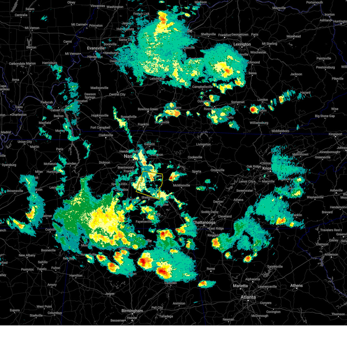
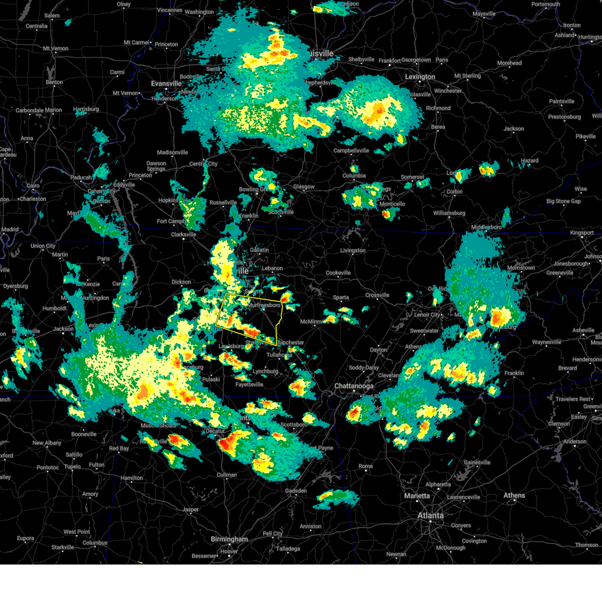
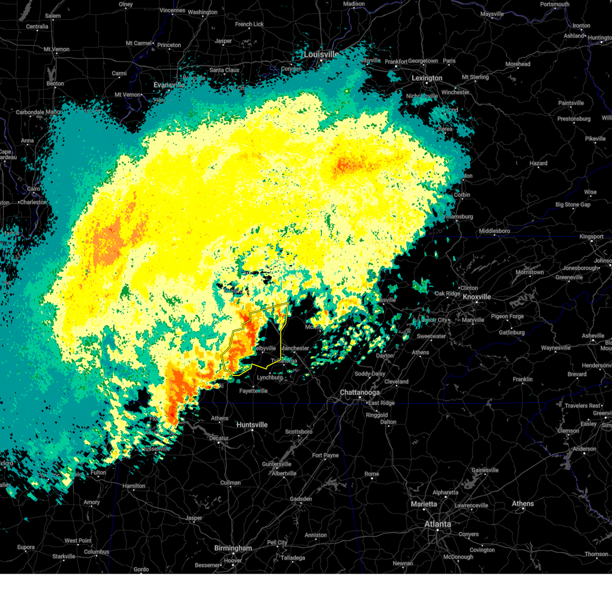
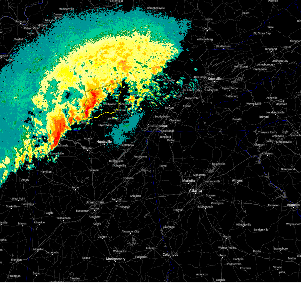
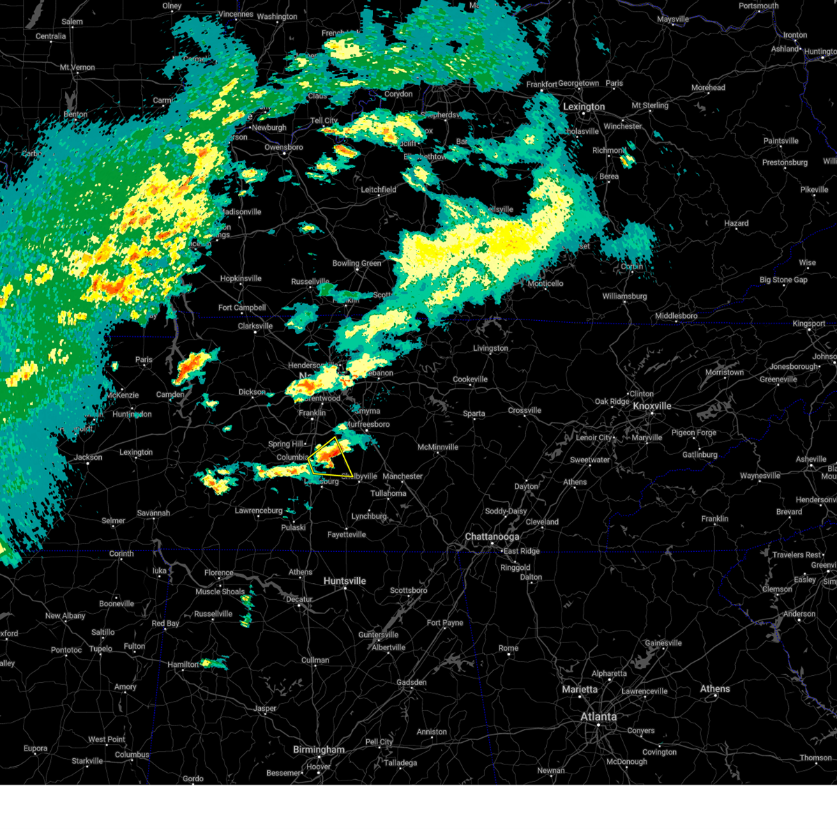
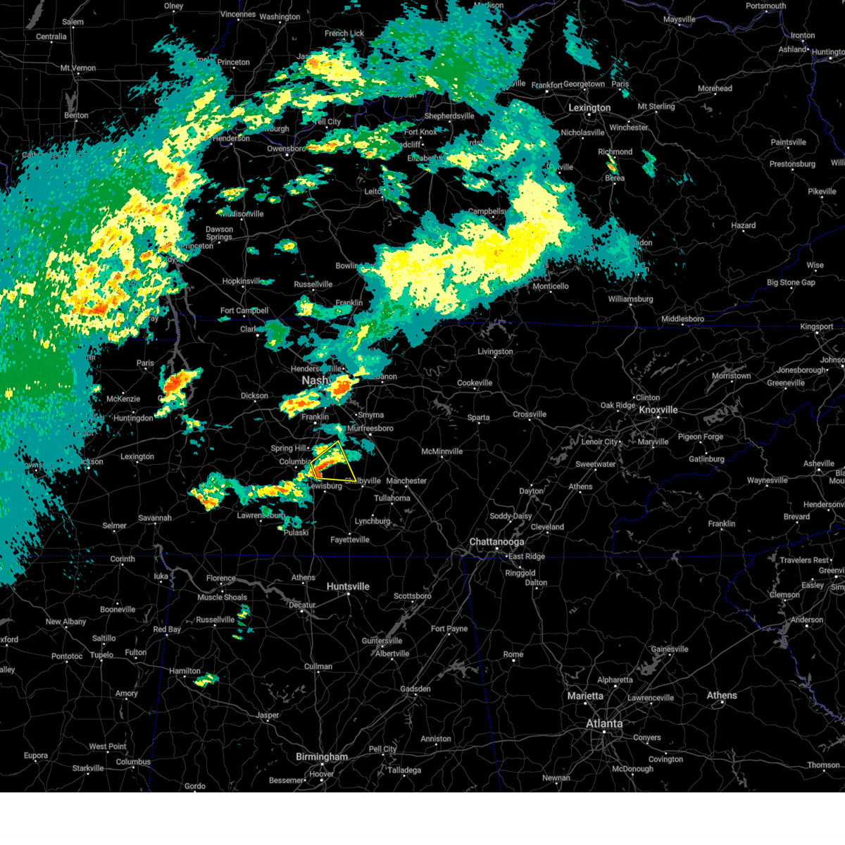
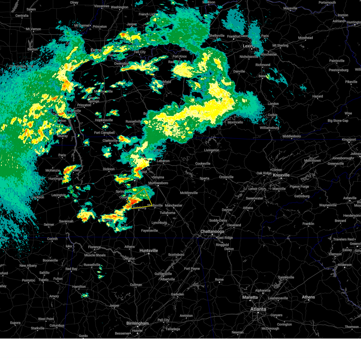
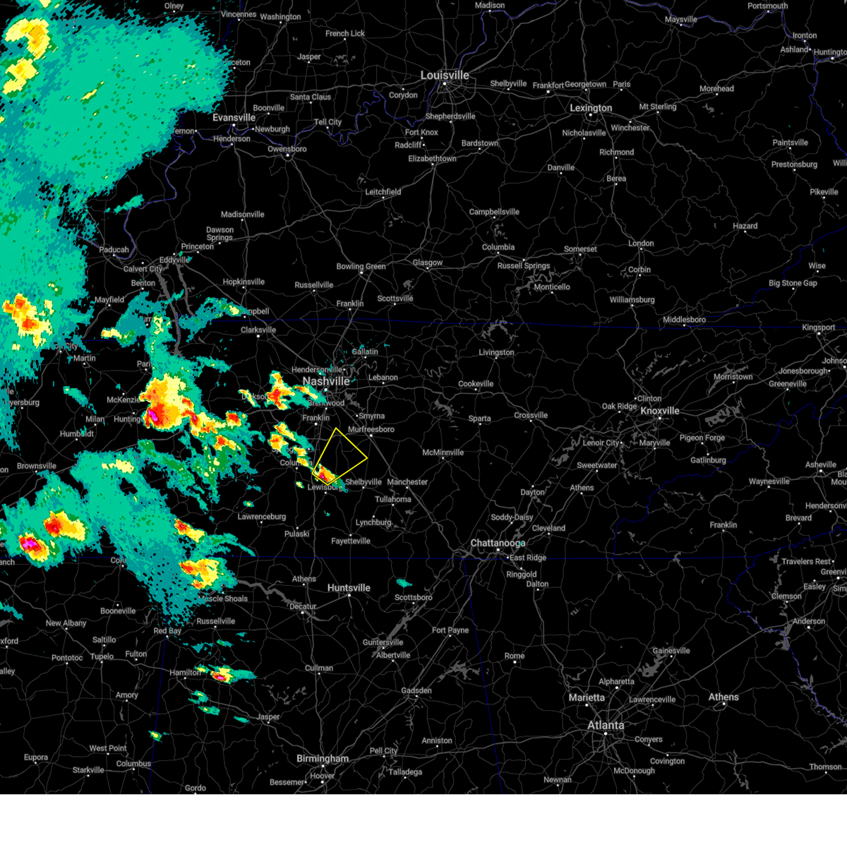
Hail Map for Unionville, TN
The Unionville, TN area has had 3 reports of on-the-ground hail by trained spotters, and has been under severe weather warnings 31 times during the past 12 months. Doppler radar has detected hail at or near Unionville, TN on 53 occasions, including 2 occasions during the past year.
| Name: | Unionville, TN |
| Where Located: | 40.1 miles SSE of Nashville, TN |
| Map: | Google Map for Unionville, TN |
| Population: | 1368 |
| Housing Units: | 513 |
| More Info: | Search Google for Unionville, TN |
2
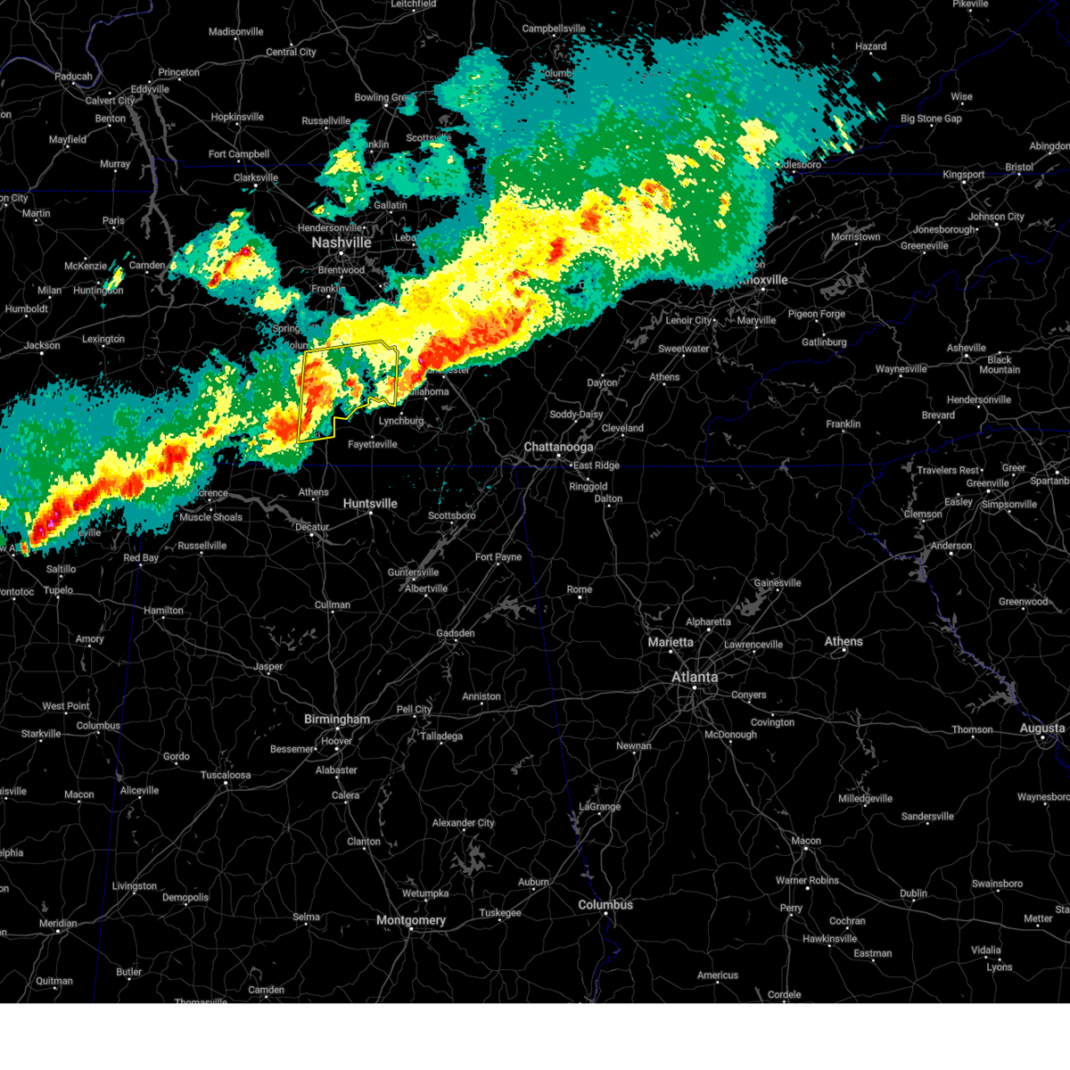
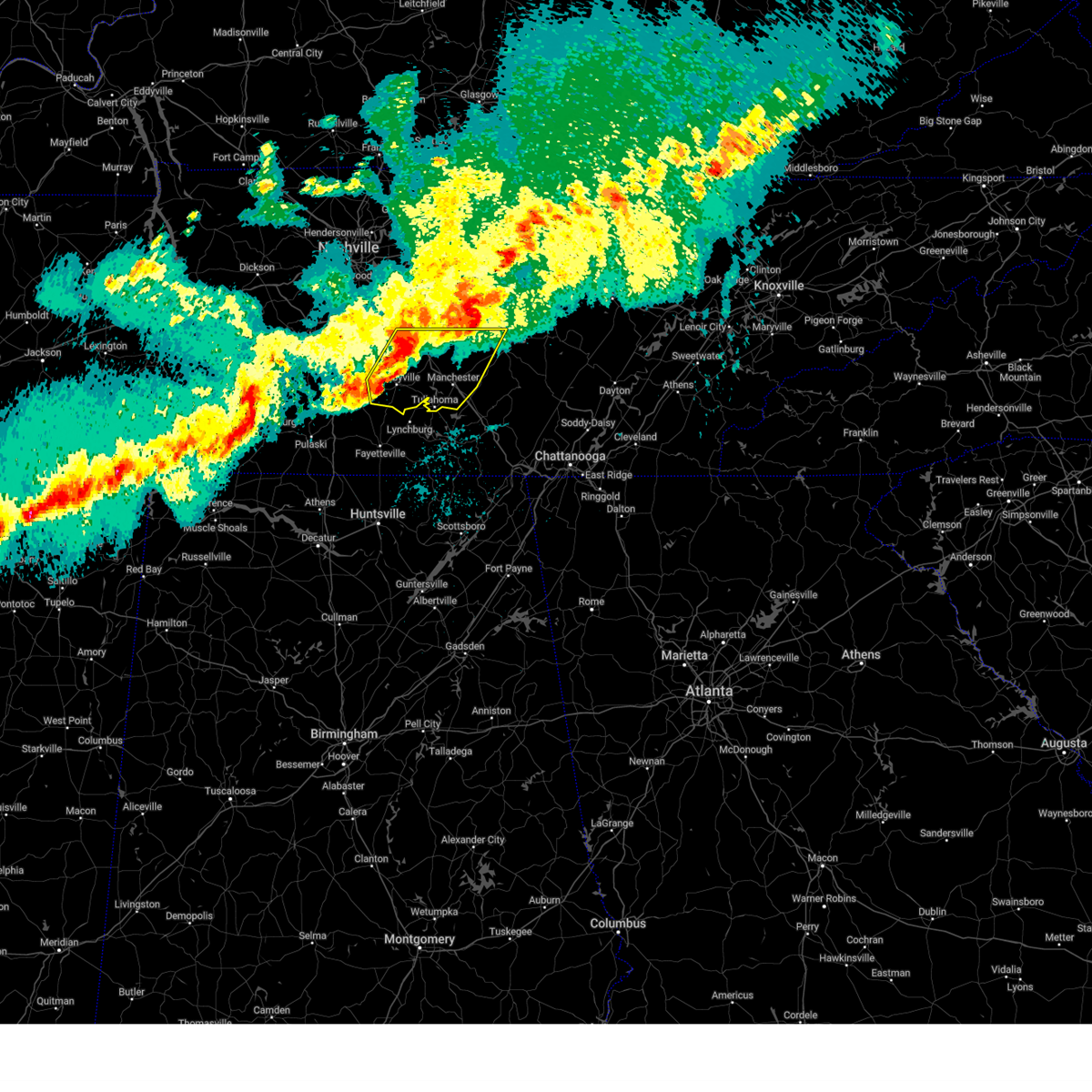
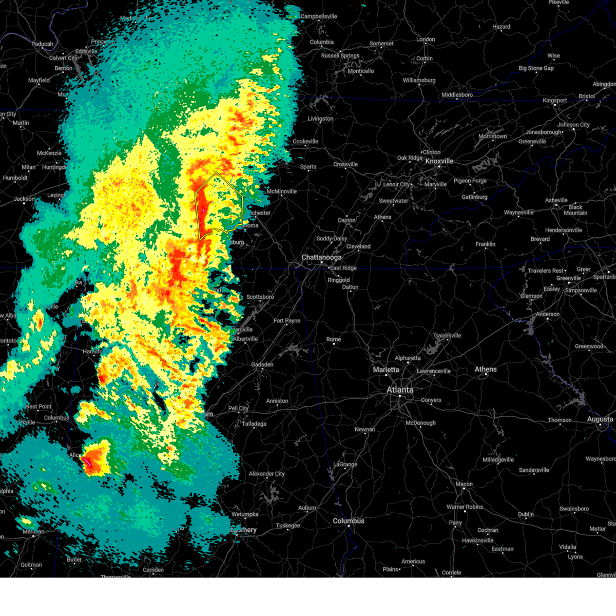
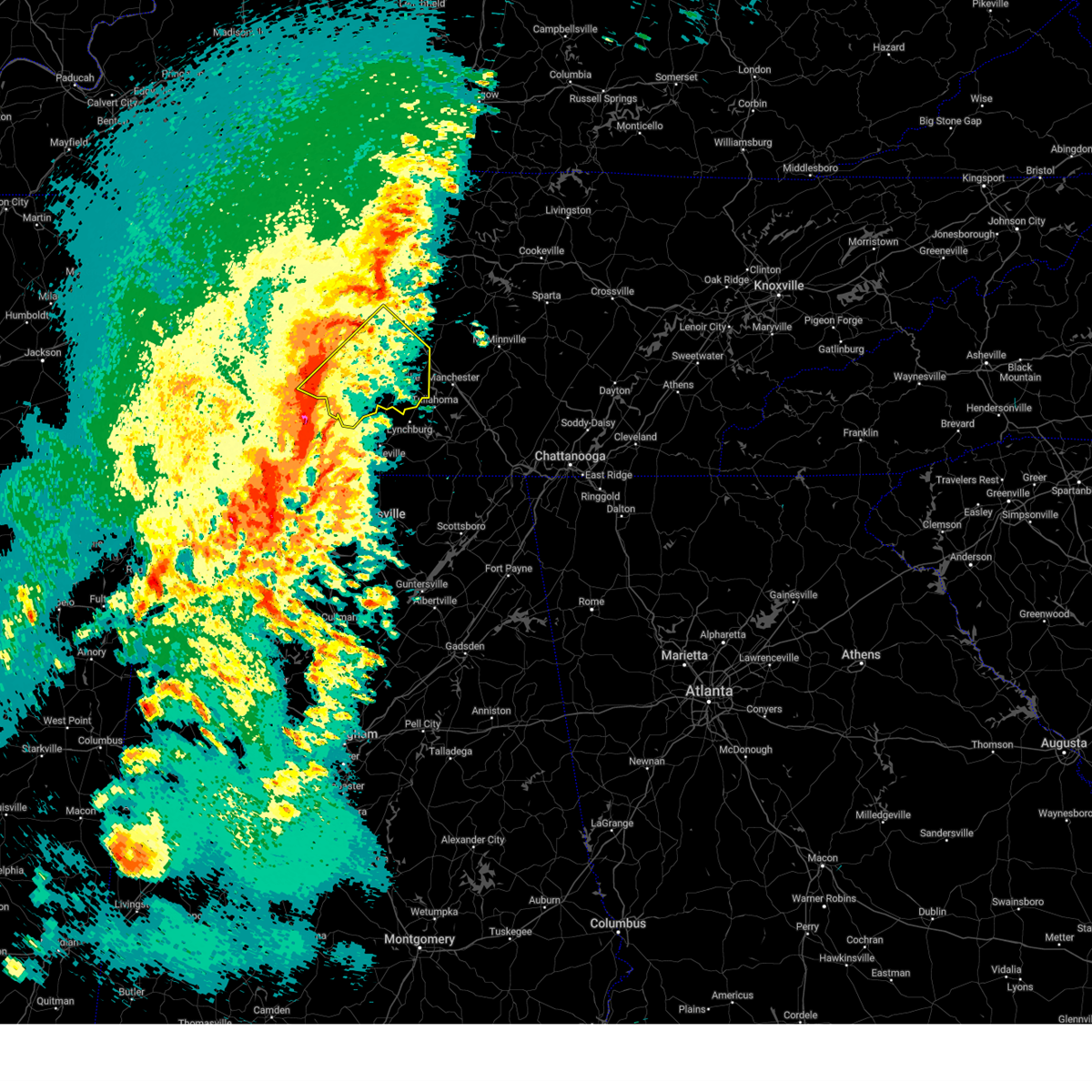
The Top Recent Hail Date for Unionville, TN is Wednesday, May 8, 2024 (8th out of 53)

Hail and Wind Damage Spotted near Unionville, TN
| Date / Time | Report Details |
|---|---|
| 4/10/2025 5:57 PM CDT |
 At 557 pm cdt, a severe thunderstorm was located near murfreesboro, moving east at 30 mph (radar indicated). Hazards include 60 mph wind gusts. Expect damage to roofs, siding, and trees. locations impacted include, lascassas, christiana, murfreesboro, bell buckle, fosterville, chapel hill, rover, eagleville, deason, rockvale, unionville, wartrace, smyrna, and walterhill. this includes the following highways, interstate 24 between mile markers 67 and 96. Interstate 840 between mile markers 46 and 58. At 557 pm cdt, a severe thunderstorm was located near murfreesboro, moving east at 30 mph (radar indicated). Hazards include 60 mph wind gusts. Expect damage to roofs, siding, and trees. locations impacted include, lascassas, christiana, murfreesboro, bell buckle, fosterville, chapel hill, rover, eagleville, deason, rockvale, unionville, wartrace, smyrna, and walterhill. this includes the following highways, interstate 24 between mile markers 67 and 96. Interstate 840 between mile markers 46 and 58.
|
| 4/10/2025 5:57 PM CDT |
 the severe thunderstorm warning has been cancelled and is no longer in effect the severe thunderstorm warning has been cancelled and is no longer in effect
|
| 4/10/2025 5:29 PM CDT |
 Svrohx the national weather service in nashville has issued a * severe thunderstorm warning for, northeastern marshall county in middle tennessee, rutherford county in middle tennessee, northeastern maury county in middle tennessee, eastern williamson county in middle tennessee, northern bedford county in middle tennessee, * until 615 pm cdt. * at 529 pm cdt, a severe thunderstorm was located near franklin, moving east at 30 mph (radar indicated). Hazards include 60 mph wind gusts. expect damage to roofs, siding, and trees Svrohx the national weather service in nashville has issued a * severe thunderstorm warning for, northeastern marshall county in middle tennessee, rutherford county in middle tennessee, northeastern maury county in middle tennessee, eastern williamson county in middle tennessee, northern bedford county in middle tennessee, * until 615 pm cdt. * at 529 pm cdt, a severe thunderstorm was located near franklin, moving east at 30 mph (radar indicated). Hazards include 60 mph wind gusts. expect damage to roofs, siding, and trees
|
| 4/5/2025 10:44 PM CDT |
 At 1044 pm cdt, severe thunderstorms were located along a line extending from 9 miles southwest of murfreesboro to 6 miles south of lewisburg, moving northeast at 55 mph (radar indicated). Hazards include 60 mph wind gusts and penny size hail. Expect damage to roofs, siding, and trees. locations impacted include, lascassas, christiana, murfreesboro, bell buckle, raus, lewisburg, fosterville, chapel hill, rover, belfast, eagleville, petersburg, deason, rockvale, shelbyville, cornersville, normandy, farmington, milton, and unionville. this includes the following highways, interstate 65 between mile markers 23 and 35. interstate 24 between mile markers 75 and 95. Interstate 840 between mile markers 45 and 53. At 1044 pm cdt, severe thunderstorms were located along a line extending from 9 miles southwest of murfreesboro to 6 miles south of lewisburg, moving northeast at 55 mph (radar indicated). Hazards include 60 mph wind gusts and penny size hail. Expect damage to roofs, siding, and trees. locations impacted include, lascassas, christiana, murfreesboro, bell buckle, raus, lewisburg, fosterville, chapel hill, rover, belfast, eagleville, petersburg, deason, rockvale, shelbyville, cornersville, normandy, farmington, milton, and unionville. this includes the following highways, interstate 65 between mile markers 23 and 35. interstate 24 between mile markers 75 and 95. Interstate 840 between mile markers 45 and 53.
|
| 4/5/2025 10:44 PM CDT |
 the severe thunderstorm warning has been cancelled and is no longer in effect the severe thunderstorm warning has been cancelled and is no longer in effect
|
| 4/5/2025 10:27 PM CDT |
 Svrohx the national weather service in nashville has issued a * severe thunderstorm warning for, marshall county in middle tennessee, rutherford county in middle tennessee, eastern maury county in middle tennessee, southeastern williamson county in middle tennessee, northeastern giles county in middle tennessee, bedford county in middle tennessee, * until 1115 pm cdt. * at 1027 pm cdt, severe thunderstorms were located along a line extending from 7 miles southeast of spring hill to 8 miles northeast of pulaski, moving northeast at 55 mph (radar indicated). Hazards include 60 mph wind gusts and quarter size hail. Hail damage to vehicles is expected. Expect wind damage to roofs, siding, and trees. Svrohx the national weather service in nashville has issued a * severe thunderstorm warning for, marshall county in middle tennessee, rutherford county in middle tennessee, eastern maury county in middle tennessee, southeastern williamson county in middle tennessee, northeastern giles county in middle tennessee, bedford county in middle tennessee, * until 1115 pm cdt. * at 1027 pm cdt, severe thunderstorms were located along a line extending from 7 miles southeast of spring hill to 8 miles northeast of pulaski, moving northeast at 55 mph (radar indicated). Hazards include 60 mph wind gusts and quarter size hail. Hail damage to vehicles is expected. Expect wind damage to roofs, siding, and trees.
|
| 4/3/2025 7:18 PM CDT |
 the severe thunderstorm warning has been cancelled and is no longer in effect the severe thunderstorm warning has been cancelled and is no longer in effect
|
| 4/3/2025 7:12 PM CDT |
 At 711 pm cdt, a severe thunderstorm was located 11 miles north of lewisburg, moving northeast at 35 mph (radar indicated). Hazards include 60 mph wind gusts and quarter size hail. Hail damage to vehicles is expected. expect wind damage to roofs, siding, and trees. locations impacted include, i-65 east of columbia, eagleville, unionville, chapel hill, and columbia. This includes interstate 65 between mile markers 45 and 47. At 711 pm cdt, a severe thunderstorm was located 11 miles north of lewisburg, moving northeast at 35 mph (radar indicated). Hazards include 60 mph wind gusts and quarter size hail. Hail damage to vehicles is expected. expect wind damage to roofs, siding, and trees. locations impacted include, i-65 east of columbia, eagleville, unionville, chapel hill, and columbia. This includes interstate 65 between mile markers 45 and 47.
|
| 4/3/2025 7:00 PM CDT |
 Svrohx the national weather service in nashville has issued a * severe thunderstorm warning for, northern marshall county in middle tennessee, western rutherford county in middle tennessee, southeastern maury county in middle tennessee, southeastern williamson county in middle tennessee, northwestern bedford county in middle tennessee, * until 730 pm cdt. * at 700 pm cdt, a severe thunderstorm was located 9 miles northwest of lewisburg, moving northeast at 35 mph (radar indicated). Hazards include 60 mph wind gusts and quarter size hail. Hail damage to vehicles is expected. Expect wind damage to roofs, siding, and trees. Svrohx the national weather service in nashville has issued a * severe thunderstorm warning for, northern marshall county in middle tennessee, western rutherford county in middle tennessee, southeastern maury county in middle tennessee, southeastern williamson county in middle tennessee, northwestern bedford county in middle tennessee, * until 730 pm cdt. * at 700 pm cdt, a severe thunderstorm was located 9 miles northwest of lewisburg, moving northeast at 35 mph (radar indicated). Hazards include 60 mph wind gusts and quarter size hail. Hail damage to vehicles is expected. Expect wind damage to roofs, siding, and trees.
|
| 4/2/2025 5:43 PM CDT |
 At 543 pm cdt, a severe thunderstorm was located 9 miles north of lewisburg, moving northeast at 50 mph (radar indicated). Hazards include 60 mph wind gusts and quarter size hail. Hail damage to vehicles is expected. expect wind damage to roofs, siding, and trees. locations impacted include, rover, eagleville, unionville, triune, chapel hill, and rockvale. This includes interstate 840 between mile markers 37 and 43. At 543 pm cdt, a severe thunderstorm was located 9 miles north of lewisburg, moving northeast at 50 mph (radar indicated). Hazards include 60 mph wind gusts and quarter size hail. Hail damage to vehicles is expected. expect wind damage to roofs, siding, and trees. locations impacted include, rover, eagleville, unionville, triune, chapel hill, and rockvale. This includes interstate 840 between mile markers 37 and 43.
|
| 4/2/2025 5:38 PM CDT |
 Svrohx the national weather service in nashville has issued a * severe thunderstorm warning for, northern marshall county in middle tennessee, southwestern rutherford county in middle tennessee, southeastern maury county in middle tennessee, southeastern williamson county in middle tennessee, northwestern bedford county in middle tennessee, * until 615 pm cdt. * at 538 pm cdt, a severe thunderstorm was located near lewisburg, moving northeast at 50 mph (radar indicated). Hazards include 60 mph wind gusts and quarter size hail. Hail damage to vehicles is expected. Expect wind damage to roofs, siding, and trees. Svrohx the national weather service in nashville has issued a * severe thunderstorm warning for, northern marshall county in middle tennessee, southwestern rutherford county in middle tennessee, southeastern maury county in middle tennessee, southeastern williamson county in middle tennessee, northwestern bedford county in middle tennessee, * until 615 pm cdt. * at 538 pm cdt, a severe thunderstorm was located near lewisburg, moving northeast at 50 mph (radar indicated). Hazards include 60 mph wind gusts and quarter size hail. Hail damage to vehicles is expected. Expect wind damage to roofs, siding, and trees.
|
| 3/31/2025 2:04 AM CDT | the severe thunderstorm warning has been cancelled and is no longer in effect |
| 3/31/2025 1:47 AM CDT | At 146 am cdt, severe thunderstorms were located along a line extending from 10 miles southeast of spring hill to 11 miles east of pulaski, moving east at 45 mph (radar indicated). Hazards include 60 mph wind gusts and penny size hail. Expect damage to roofs, siding, and trees. locations impacted include, belfast, deason, frankewing, shelbyville, cornersville, farmington, lewisburg, unionville, and chapel hill. This includes interstate 65 between mile markers 11 and 34. |
| 3/31/2025 1:47 AM CDT | the severe thunderstorm warning has been cancelled and is no longer in effect |
| 3/31/2025 1:35 AM CDT |
 Svrohx the national weather service in nashville has issued a * severe thunderstorm warning for, marshall county in middle tennessee, southeastern maury county in middle tennessee, northeastern giles county in middle tennessee, bedford county in middle tennessee, * until 215 am cdt. * at 135 am cdt, severe thunderstorms were located along a line extending from 6 miles east of columbia to near pulaski, moving east at 45 mph (radar indicated). Hazards include 60 mph wind gusts and penny size hail. expect damage to roofs, siding, and trees Svrohx the national weather service in nashville has issued a * severe thunderstorm warning for, marshall county in middle tennessee, southeastern maury county in middle tennessee, northeastern giles county in middle tennessee, bedford county in middle tennessee, * until 215 am cdt. * at 135 am cdt, severe thunderstorms were located along a line extending from 6 miles east of columbia to near pulaski, moving east at 45 mph (radar indicated). Hazards include 60 mph wind gusts and penny size hail. expect damage to roofs, siding, and trees
|
| 3/31/2025 1:05 AM CDT |
 Svrohx the national weather service in nashville has issued a * severe thunderstorm warning for, southeastern rutherford county in middle tennessee, western warren county in middle tennessee, coffee county in middle tennessee, bedford county in middle tennessee, southern cannon county in middle tennessee, * until 200 am cdt. * at 105 am cdt, severe thunderstorms were located along a line extending from 13 miles southeast of murfreesboro to near petersburg, moving east at 30 mph (radar indicated). Hazards include 60 mph wind gusts and penny size hail. expect damage to roofs, siding, and trees Svrohx the national weather service in nashville has issued a * severe thunderstorm warning for, southeastern rutherford county in middle tennessee, western warren county in middle tennessee, coffee county in middle tennessee, bedford county in middle tennessee, southern cannon county in middle tennessee, * until 200 am cdt. * at 105 am cdt, severe thunderstorms were located along a line extending from 13 miles southeast of murfreesboro to near petersburg, moving east at 30 mph (radar indicated). Hazards include 60 mph wind gusts and penny size hail. expect damage to roofs, siding, and trees
|
| 3/15/2025 3:58 PM CDT | Rutherford county fire working 2 reports of large trees blocking roadways in christiana. 6700blk williams rd... 4500blk jones r in rutherford county TN, 8.2 miles SW of Unionville, TN |
| 3/15/2025 3:55 PM CDT | Tree uprooted and damage to a metal building was reported near christian in bedford county TN, 6.4 miles SW of Unionville, TN |
| 3/15/2025 3:19 PM CDT | Relayed from a tspotter... damage to a powerline and a tree at the intersection of longview road and pepper hil in bedford county TN, 2.3 miles SSW of Unionville, TN |
| 3/15/2025 3:18 PM CDT | Possible structure damage near kingdom road. tspotte in bedford county TN, 4.9 miles S of Unionville, TN |
| 3/15/2025 3:15 PM CDT |
 At 315 pm cdt, severe thunderstorms were located along a line extending from 13 miles south of nolensville to near petersburg, moving east at 55 mph (radar indicated). Hazards include 60 mph wind gusts and penny size hail. Expect damage to roofs, siding, and trees. locations impacted include, christiana, bell buckle, raus, fosterville, chapel hill, rover, belfast, eagleville, deason, rockvale, shelbyville, normandy, farmington, unionville, wartrace, lewisburg, and murfreesboro. this includes the following highways, interstate 24 between mile markers 85 and 97. Interstate 840 between mile markers 44 and 51. At 315 pm cdt, severe thunderstorms were located along a line extending from 13 miles south of nolensville to near petersburg, moving east at 55 mph (radar indicated). Hazards include 60 mph wind gusts and penny size hail. Expect damage to roofs, siding, and trees. locations impacted include, christiana, bell buckle, raus, fosterville, chapel hill, rover, belfast, eagleville, deason, rockvale, shelbyville, normandy, farmington, unionville, wartrace, lewisburg, and murfreesboro. this includes the following highways, interstate 24 between mile markers 85 and 97. Interstate 840 between mile markers 44 and 51.
|
| 3/15/2025 3:15 PM CDT |
 the severe thunderstorm warning has been cancelled and is no longer in effect the severe thunderstorm warning has been cancelled and is no longer in effect
|
| 3/15/2025 2:55 PM CDT |
 Svrohx the national weather service in nashville has issued a * severe thunderstorm warning for, marshall county in middle tennessee, southwestern rutherford county in middle tennessee, southeastern maury county in middle tennessee, southeastern williamson county in middle tennessee, bedford county in middle tennessee, * until 345 pm cdt. * at 255 pm cdt, severe thunderstorms were located along a line extending from 6 miles east of columbia to 8 miles northeast of pulaski, moving northeast at 70 mph (radar indicated). Hazards include 60 mph wind gusts and penny size hail. expect damage to roofs, siding, and trees Svrohx the national weather service in nashville has issued a * severe thunderstorm warning for, marshall county in middle tennessee, southwestern rutherford county in middle tennessee, southeastern maury county in middle tennessee, southeastern williamson county in middle tennessee, bedford county in middle tennessee, * until 345 pm cdt. * at 255 pm cdt, severe thunderstorms were located along a line extending from 6 miles east of columbia to 8 miles northeast of pulaski, moving northeast at 70 mph (radar indicated). Hazards include 60 mph wind gusts and penny size hail. expect damage to roofs, siding, and trees
|
| 5/22/2024 6:27 PM CDT |
 The storm which prompted the warning has weakened below severe limits, and no longer poses an immediate threat to life or property. therefore, the warning will be allowed to expire. however, gusty winds and heavy rain are still possible with this thunderstorm. a severe thunderstorm watch remains in effect until 1000 pm cdt for middle tennessee. The storm which prompted the warning has weakened below severe limits, and no longer poses an immediate threat to life or property. therefore, the warning will be allowed to expire. however, gusty winds and heavy rain are still possible with this thunderstorm. a severe thunderstorm watch remains in effect until 1000 pm cdt for middle tennessee.
|
| 5/22/2024 6:13 PM CDT |
 At 612 pm cdt, a severe thunderstorm was located 7 miles northeast of petersburg, or 9 miles southwest of shelbyville, moving east at 50 mph (radar indicated). Hazards include 60 mph wind gusts and penny size hail. Expect damage to roofs, siding, and trees. Locations impacted include, shelbyville, lewisburg, petersburg, wartrace, bell buckle, normandy, belfast, deason, farmington, and raus. At 612 pm cdt, a severe thunderstorm was located 7 miles northeast of petersburg, or 9 miles southwest of shelbyville, moving east at 50 mph (radar indicated). Hazards include 60 mph wind gusts and penny size hail. Expect damage to roofs, siding, and trees. Locations impacted include, shelbyville, lewisburg, petersburg, wartrace, bell buckle, normandy, belfast, deason, farmington, and raus.
|
| 5/22/2024 5:59 PM CDT |
 At 559 pm cdt, a severe thunderstorm was located near lewisburg, moving east at 50 mph (radar indicated). Hazards include 60 mph wind gusts and penny size hail. Expect damage to roofs, siding, and trees. locations impacted include, shelbyville, lewisburg, petersburg, cornersville, wartrace, bell buckle, normandy, belfast, deason, farmington, unionville, and raus. This includes interstate 65 between mile markers 23 and 36. At 559 pm cdt, a severe thunderstorm was located near lewisburg, moving east at 50 mph (radar indicated). Hazards include 60 mph wind gusts and penny size hail. Expect damage to roofs, siding, and trees. locations impacted include, shelbyville, lewisburg, petersburg, cornersville, wartrace, bell buckle, normandy, belfast, deason, farmington, unionville, and raus. This includes interstate 65 between mile markers 23 and 36.
|
| 5/22/2024 5:59 PM CDT |
 the severe thunderstorm warning has been cancelled and is no longer in effect the severe thunderstorm warning has been cancelled and is no longer in effect
|
| 5/22/2024 5:48 PM CDT |
 Svrohx the national weather service in nashville has issued a * severe thunderstorm warning for, marshall county in middle tennessee, southeastern maury county in middle tennessee, northeastern giles county in middle tennessee, bedford county in middle tennessee, * until 630 pm cdt. * at 548 pm cdt, a severe thunderstorm was located 10 miles southwest of lewisburg, moving east at 55 mph (radar indicated). Hazards include 60 mph wind gusts and penny size hail. expect damage to roofs, siding, and trees Svrohx the national weather service in nashville has issued a * severe thunderstorm warning for, marshall county in middle tennessee, southeastern maury county in middle tennessee, northeastern giles county in middle tennessee, bedford county in middle tennessee, * until 630 pm cdt. * at 548 pm cdt, a severe thunderstorm was located 10 miles southwest of lewisburg, moving east at 55 mph (radar indicated). Hazards include 60 mph wind gusts and penny size hail. expect damage to roofs, siding, and trees
|
| 5/14/2024 5:13 PM CDT |
 Svrohx the national weather service in nashville has issued a * severe thunderstorm warning for, northeastern marshall county in middle tennessee, southern rutherford county in middle tennessee, western coffee county in middle tennessee, bedford county in middle tennessee, * until 600 pm cdt. * at 513 pm cdt, severe thunderstorms were located along a line extending from 13 miles east of spring hill to near shelbyville to near petersburg, moving east at 45 mph (radar indicated). Hazards include 60 mph wind gusts. expect damage to roofs, siding, and trees Svrohx the national weather service in nashville has issued a * severe thunderstorm warning for, northeastern marshall county in middle tennessee, southern rutherford county in middle tennessee, western coffee county in middle tennessee, bedford county in middle tennessee, * until 600 pm cdt. * at 513 pm cdt, severe thunderstorms were located along a line extending from 13 miles east of spring hill to near shelbyville to near petersburg, moving east at 45 mph (radar indicated). Hazards include 60 mph wind gusts. expect damage to roofs, siding, and trees
|
| 5/14/2024 4:49 PM CDT |
 Svrohx the national weather service in nashville has issued a * severe thunderstorm warning for, marshall county in middle tennessee, southwestern rutherford county in middle tennessee, eastern maury county in middle tennessee, eastern williamson county in middle tennessee, bedford county in middle tennessee, * until 515 pm cdt. * at 449 pm cdt, severe thunderstorms were located along a line extending from near thompson's station to 8 miles west of petersburg, moving northeast at 45 mph (radar indicated). Hazards include 60 mph wind gusts and penny size hail. expect damage to roofs, siding, and trees Svrohx the national weather service in nashville has issued a * severe thunderstorm warning for, marshall county in middle tennessee, southwestern rutherford county in middle tennessee, eastern maury county in middle tennessee, eastern williamson county in middle tennessee, bedford county in middle tennessee, * until 515 pm cdt. * at 449 pm cdt, severe thunderstorms were located along a line extending from near thompson's station to 8 miles west of petersburg, moving northeast at 45 mph (radar indicated). Hazards include 60 mph wind gusts and penny size hail. expect damage to roofs, siding, and trees
|
| 5/8/2024 7:21 PM CDT |
 At 721 pm cdt, a severe thunderstorm capable of producing a tornado was located 10 miles northeast of lewisburg, moving east at 30 mph (radar indicated rotation). Hazards include tornado and half dollar size hail. Flying debris will be dangerous to those caught without shelter. mobile homes will be damaged or destroyed. damage to roofs, windows, and vehicles will occur. tree damage is likely. this dangerous storm will be near, shelbyville around 730 pm cdt. Other locations impacted by this tornadic thunderstorm include deason, farmington, unionville, fosterville, chapel hill, and bell buckle. At 721 pm cdt, a severe thunderstorm capable of producing a tornado was located 10 miles northeast of lewisburg, moving east at 30 mph (radar indicated rotation). Hazards include tornado and half dollar size hail. Flying debris will be dangerous to those caught without shelter. mobile homes will be damaged or destroyed. damage to roofs, windows, and vehicles will occur. tree damage is likely. this dangerous storm will be near, shelbyville around 730 pm cdt. Other locations impacted by this tornadic thunderstorm include deason, farmington, unionville, fosterville, chapel hill, and bell buckle.
|
| 5/8/2024 7:08 PM CDT |
 Torohx the national weather service in nashville has issued a * tornado warning for, central marshall county in middle tennessee, south central rutherford county in middle tennessee, northwestern bedford county in middle tennessee, * until 745 pm cdt. * at 708 pm cdt, a severe thunderstorm capable of producing a tornado was located near lewisburg, moving east at 30 mph (radar indicated rotation). Hazards include tornado and half dollar size hail. Flying debris will be dangerous to those caught without shelter. mobile homes will be damaged or destroyed. damage to roofs, windows, and vehicles will occur. tree damage is likely. this dangerous storm will be near, shelbyville around 735 pm cdt. Other locations impacted by this tornadic thunderstorm include deason, farmington, unionville, fosterville, chapel hill, and bell buckle. Torohx the national weather service in nashville has issued a * tornado warning for, central marshall county in middle tennessee, south central rutherford county in middle tennessee, northwestern bedford county in middle tennessee, * until 745 pm cdt. * at 708 pm cdt, a severe thunderstorm capable of producing a tornado was located near lewisburg, moving east at 30 mph (radar indicated rotation). Hazards include tornado and half dollar size hail. Flying debris will be dangerous to those caught without shelter. mobile homes will be damaged or destroyed. damage to roofs, windows, and vehicles will occur. tree damage is likely. this dangerous storm will be near, shelbyville around 735 pm cdt. Other locations impacted by this tornadic thunderstorm include deason, farmington, unionville, fosterville, chapel hill, and bell buckle.
|
| 5/8/2024 7:00 PM CDT |
 Svrohx the national weather service in nashville has issued a * severe thunderstorm warning for, central marshall county in middle tennessee, south central rutherford county in middle tennessee, southeastern maury county in middle tennessee, bedford county in middle tennessee, * until 745 pm cdt. * at 700 pm cdt, a severe thunderstorm was located near lewisburg, moving east at 30 mph (radar indicated). Hazards include 60 mph wind gusts and quarter size hail. Hail damage to vehicles is expected. Expect wind damage to roofs, siding, and trees. Svrohx the national weather service in nashville has issued a * severe thunderstorm warning for, central marshall county in middle tennessee, south central rutherford county in middle tennessee, southeastern maury county in middle tennessee, bedford county in middle tennessee, * until 745 pm cdt. * at 700 pm cdt, a severe thunderstorm was located near lewisburg, moving east at 30 mph (radar indicated). Hazards include 60 mph wind gusts and quarter size hail. Hail damage to vehicles is expected. Expect wind damage to roofs, siding, and trees.
|
| 5/8/2024 6:52 PM CDT | Photo received of large tree down and tree resting on powerlines and on top of a house. time is radar estimated. tornado damage possibl in rutherford county TN, 7.7 miles SW of Unionville, TN |
| 5/8/2024 6:52 PM CDT |
 Svrohx the national weather service in nashville has issued a * severe thunderstorm warning for, northeastern marshall county in middle tennessee, southwestern rutherford county in middle tennessee, southeastern williamson county in middle tennessee, northern bedford county in middle tennessee, * until 715 pm cdt. * at 652 pm cdt, a severe thunderstorm was located 14 miles southwest of murfreesboro, moving east at 30 mph (radar indicated). Hazards include 60 mph wind gusts and half dollar size hail. Hail damage to vehicles is expected. Expect wind damage to roofs, siding, and trees. Svrohx the national weather service in nashville has issued a * severe thunderstorm warning for, northeastern marshall county in middle tennessee, southwestern rutherford county in middle tennessee, southeastern williamson county in middle tennessee, northern bedford county in middle tennessee, * until 715 pm cdt. * at 652 pm cdt, a severe thunderstorm was located 14 miles southwest of murfreesboro, moving east at 30 mph (radar indicated). Hazards include 60 mph wind gusts and half dollar size hail. Hail damage to vehicles is expected. Expect wind damage to roofs, siding, and trees.
|
| 5/8/2024 6:10 PM CDT |
 Torohx the national weather service in nashville has issued a * tornado warning for, northeastern marshall county in middle tennessee, southwestern rutherford county in middle tennessee, east central maury county in middle tennessee, southeastern williamson county in middle tennessee, northwestern bedford county in middle tennessee, * until 645 pm cdt. * at 610 pm cdt, a confirmed tornado was located 8 miles southeast of spring hill, or 15 miles east of columbia, moving east at 25 mph (weather spotters confirmed tornado). Hazards include damaging tornado and quarter size hail. Flying debris will be dangerous to those caught without shelter. mobile homes will be damaged or destroyed. damage to roofs, windows, and vehicles will occur. tree damage is likely. this tornadic thunderstorm will remain over mainly rural areas of northeastern marshall, southwestern rutherford, east central maury, southeastern williamson and northwestern bedford counties, including the following locations, rover, eagleville, unionville, chapel hill, and rockvale. this includes the following highways, interstate 65 between mile markers 49 and 54. Interstate 840 between mile markers 43 and 50. Torohx the national weather service in nashville has issued a * tornado warning for, northeastern marshall county in middle tennessee, southwestern rutherford county in middle tennessee, east central maury county in middle tennessee, southeastern williamson county in middle tennessee, northwestern bedford county in middle tennessee, * until 645 pm cdt. * at 610 pm cdt, a confirmed tornado was located 8 miles southeast of spring hill, or 15 miles east of columbia, moving east at 25 mph (weather spotters confirmed tornado). Hazards include damaging tornado and quarter size hail. Flying debris will be dangerous to those caught without shelter. mobile homes will be damaged or destroyed. damage to roofs, windows, and vehicles will occur. tree damage is likely. this tornadic thunderstorm will remain over mainly rural areas of northeastern marshall, southwestern rutherford, east central maury, southeastern williamson and northwestern bedford counties, including the following locations, rover, eagleville, unionville, chapel hill, and rockvale. this includes the following highways, interstate 65 between mile markers 49 and 54. Interstate 840 between mile markers 43 and 50.
|
| 12/9/2023 7:18 PM CST |
 At 718 pm cst, a severe thunderstorm capable of producing a tornado was located 11 miles southwest of murfreesboro, or near rover, moving northeast at 45 mph (radar indicated rotation). Hazards include tornado. Flying debris will be dangerous to those caught without shelter. mobile homes will be damaged or destroyed. damage to roofs, windows, and vehicles will occur. tree damage is likely. this dangerous storm will be near, murfreesboro around 725 pm cst. other locations impacted by this tornadic thunderstorm include christiana, milton, fosterville, and rockvale. This includes interstate 24 between mile markers 79 and 92. At 718 pm cst, a severe thunderstorm capable of producing a tornado was located 11 miles southwest of murfreesboro, or near rover, moving northeast at 45 mph (radar indicated rotation). Hazards include tornado. Flying debris will be dangerous to those caught without shelter. mobile homes will be damaged or destroyed. damage to roofs, windows, and vehicles will occur. tree damage is likely. this dangerous storm will be near, murfreesboro around 725 pm cst. other locations impacted by this tornadic thunderstorm include christiana, milton, fosterville, and rockvale. This includes interstate 24 between mile markers 79 and 92.
|
| 8/12/2023 12:29 PM CDT |
 At 1228 pm cdt, severe thunderstorms were located along a line extending from murfreesboro to near lewisburg, moving east at 50 mph (radar indicated). Hazards include 60 mph wind gusts. expect damage to roofs, siding, and trees At 1228 pm cdt, severe thunderstorms were located along a line extending from murfreesboro to near lewisburg, moving east at 50 mph (radar indicated). Hazards include 60 mph wind gusts. expect damage to roofs, siding, and trees
|
| 8/12/2023 12:12 PM CDT |
 At 1211 pm cdt, severe thunderstorms were located along a line extending from 9 miles west of murfreesboro to 6 miles west of lewisburg, moving east at 45 mph (radar indicated). Hazards include 60 mph wind gusts. Expect damage to roofs, siding, and trees. locations impacted include, murfreesboro, columbia, shelbyville, lewisburg, spring hill, chapel hill, eagleville, christiana, culleoka, i-65 east of columbia, triune, fosterville, rover, belfast, deason, rockvale, farmington and unionville. this includes the following highways, interstate 65 between mile markers 29 and 51. interstate 24 between mile markers 81 and 90. interstate 840 between mile markers 35 and 44. hail threat, radar indicated max hail size, <. 75 in wind threat, radar indicated max wind gust, 60 mph. At 1211 pm cdt, severe thunderstorms were located along a line extending from 9 miles west of murfreesboro to 6 miles west of lewisburg, moving east at 45 mph (radar indicated). Hazards include 60 mph wind gusts. Expect damage to roofs, siding, and trees. locations impacted include, murfreesboro, columbia, shelbyville, lewisburg, spring hill, chapel hill, eagleville, christiana, culleoka, i-65 east of columbia, triune, fosterville, rover, belfast, deason, rockvale, farmington and unionville. this includes the following highways, interstate 65 between mile markers 29 and 51. interstate 24 between mile markers 81 and 90. interstate 840 between mile markers 35 and 44. hail threat, radar indicated max hail size, <. 75 in wind threat, radar indicated max wind gust, 60 mph.
|
| 8/12/2023 11:56 AM CDT |
 At 1155 am cdt, severe thunderstorms were located along a line extending from franklin to mount pleasant, moving east at 45 mph (radar indicated). Hazards include 60 mph wind gusts. expect damage to roofs, siding, and trees At 1155 am cdt, severe thunderstorms were located along a line extending from franklin to mount pleasant, moving east at 45 mph (radar indicated). Hazards include 60 mph wind gusts. expect damage to roofs, siding, and trees
|
| 7/18/2023 4:56 PM CDT |
 At 456 pm cdt, severe thunderstorms were located along a line extending from 7 miles south of murfreesboro to 13 miles west of ardmore, moving southeast at 50 mph (radar indicated). Hazards include 60 mph wind gusts and penny size hail. expect damage to roofs, siding, and trees At 456 pm cdt, severe thunderstorms were located along a line extending from 7 miles south of murfreesboro to 13 miles west of ardmore, moving southeast at 50 mph (radar indicated). Hazards include 60 mph wind gusts and penny size hail. expect damage to roofs, siding, and trees
|
| 7/18/2023 4:41 PM CDT |
 At 440 pm cdt, severe thunderstorms were located along a line extending from near murfreesboro to 14 miles southeast of spring hill to 11 miles north of pulaski, moving southeast at 50 mph (radar indicated). Hazards include 60 mph wind gusts and penny size hail. Expect damage to roofs, siding, and trees. locations impacted include, murfreesboro, franklin, columbia, shelbyville, lewisburg, smyrna, brentwood, la vergne, spring hill, nolensville, thompson`s station, petersburg, chapel hill, cornersville, wartrace, eagleville, bell buckle, culleoka, fosterville and triune. this includes the following highways, interstate 65 between mile markers 23 and 64. interstate 24 between mile markers 64 and 95. interstate 840 between mile markers 29 and 58. hail threat, radar indicated max hail size, 0. 75 in wind threat, radar indicated max wind gust, 60 mph. At 440 pm cdt, severe thunderstorms were located along a line extending from near murfreesboro to 14 miles southeast of spring hill to 11 miles north of pulaski, moving southeast at 50 mph (radar indicated). Hazards include 60 mph wind gusts and penny size hail. Expect damage to roofs, siding, and trees. locations impacted include, murfreesboro, franklin, columbia, shelbyville, lewisburg, smyrna, brentwood, la vergne, spring hill, nolensville, thompson`s station, petersburg, chapel hill, cornersville, wartrace, eagleville, bell buckle, culleoka, fosterville and triune. this includes the following highways, interstate 65 between mile markers 23 and 64. interstate 24 between mile markers 64 and 95. interstate 840 between mile markers 29 and 58. hail threat, radar indicated max hail size, 0. 75 in wind threat, radar indicated max wind gust, 60 mph.
|
| 7/18/2023 4:27 PM CDT |
 At 427 pm cdt, severe thunderstorms were located along a line extending from near la vergne to 7 miles east of spring hill to near mount pleasant, moving southeast at 45 mph (radar indicated). Hazards include 60 mph wind gusts and penny size hail. Expect damage to roofs, siding, and trees. locations impacted include, murfreesboro, franklin, columbia, shelbyville, lewisburg, nashville, smyrna, brentwood, la vergne, spring hill, nolensville, forest hills, mount pleasant, oak hill, belle meade, thompson`s station, petersburg, antioch, walterhill and chapel hill. this includes the following highways, interstate 40 between mile markers 206 and 217. interstate 65 between mile markers 23 and 88. interstate 24 between mile markers 44 and 95. interstate 840 between mile markers 22 and 61. hail threat, radar indicated max hail size, 0. 75 in wind threat, radar indicated max wind gust, 60 mph. At 427 pm cdt, severe thunderstorms were located along a line extending from near la vergne to 7 miles east of spring hill to near mount pleasant, moving southeast at 45 mph (radar indicated). Hazards include 60 mph wind gusts and penny size hail. Expect damage to roofs, siding, and trees. locations impacted include, murfreesboro, franklin, columbia, shelbyville, lewisburg, nashville, smyrna, brentwood, la vergne, spring hill, nolensville, forest hills, mount pleasant, oak hill, belle meade, thompson`s station, petersburg, antioch, walterhill and chapel hill. this includes the following highways, interstate 40 between mile markers 206 and 217. interstate 65 between mile markers 23 and 88. interstate 24 between mile markers 44 and 95. interstate 840 between mile markers 22 and 61. hail threat, radar indicated max hail size, 0. 75 in wind threat, radar indicated max wind gust, 60 mph.
|
| 7/18/2023 4:11 PM CDT |
 At 411 pm cdt, severe thunderstorms were located along a line extending from near nashville to near franklin to 6 miles northwest of mount pleasant, moving southeast at 45 mph (radar indicated). Hazards include 60 mph wind gusts and penny size hail. expect damage to roofs, siding, and trees At 411 pm cdt, severe thunderstorms were located along a line extending from near nashville to near franklin to 6 miles northwest of mount pleasant, moving southeast at 45 mph (radar indicated). Hazards include 60 mph wind gusts and penny size hail. expect damage to roofs, siding, and trees
|
| 6/29/2023 2:33 PM CDT |
 At 232 pm cdt, a severe thunderstorm was located 8 miles northwest of lynchburg, moving south at 45 mph (radar indicated). Hazards include 60 mph wind gusts. Expect damage to roofs, siding, and trees. locations impacted include, shelbyville, wartrace, bell buckle, normandy, raus and deason. hail threat, radar indicated max hail size, <. 75 in wind threat, radar indicated max wind gust, 60 mph. At 232 pm cdt, a severe thunderstorm was located 8 miles northwest of lynchburg, moving south at 45 mph (radar indicated). Hazards include 60 mph wind gusts. Expect damage to roofs, siding, and trees. locations impacted include, shelbyville, wartrace, bell buckle, normandy, raus and deason. hail threat, radar indicated max hail size, <. 75 in wind threat, radar indicated max wind gust, 60 mph.
|
| 6/29/2023 2:11 PM CDT |
 At 210 pm cdt, a severe thunderstorm was located 7 miles northwest of shelbyville, moving south at 45 mph (radar indicated). Hazards include 60 mph wind gusts. expect damage to roofs, siding, and trees At 210 pm cdt, a severe thunderstorm was located 7 miles northwest of shelbyville, moving south at 45 mph (radar indicated). Hazards include 60 mph wind gusts. expect damage to roofs, siding, and trees
|
| 6/29/2023 1:56 PM CDT |
 At 155 pm cdt, severe thunderstorms were located along a line extending from 13 miles east of spring hill to 8 miles southwest of murfreesboro to 10 miles southeast of walterhill, moving southeast at 40 mph (radar indicated). Hazards include 60 mph wind gusts. expect damage to roofs, siding, and trees At 155 pm cdt, severe thunderstorms were located along a line extending from 13 miles east of spring hill to 8 miles southwest of murfreesboro to 10 miles southeast of walterhill, moving southeast at 40 mph (radar indicated). Hazards include 60 mph wind gusts. expect damage to roofs, siding, and trees
|
| 6/15/2023 2:08 PM CDT |
 At 207 pm cdt, a severe thunderstorm was located 14 miles south of nolensville, or 15 miles southwest of murfreesboro, moving southeast at 20 mph (emergency management). Hazards include 60 mph wind gusts and penny size hail. Expect damage to roofs, siding, and trees. locations impacted include, chapel hill, eagleville, rover, unionville and rockvale. hail threat, radar indicated max hail size, 0. 75 in wind threat, radar indicated max wind gust, 60 mph. At 207 pm cdt, a severe thunderstorm was located 14 miles south of nolensville, or 15 miles southwest of murfreesboro, moving southeast at 20 mph (emergency management). Hazards include 60 mph wind gusts and penny size hail. Expect damage to roofs, siding, and trees. locations impacted include, chapel hill, eagleville, rover, unionville and rockvale. hail threat, radar indicated max hail size, 0. 75 in wind threat, radar indicated max wind gust, 60 mph.
|
| 6/15/2023 1:52 PM CDT |
 At 151 pm cdt, a severe thunderstorm was located 10 miles east of thompson`s station, or 12 miles southeast of franklin, moving southeast at 20 mph (emergency management). Hazards include 60 mph wind gusts and penny size hail. expect damage to roofs, siding, and trees At 151 pm cdt, a severe thunderstorm was located 10 miles east of thompson`s station, or 12 miles southeast of franklin, moving southeast at 20 mph (emergency management). Hazards include 60 mph wind gusts and penny size hail. expect damage to roofs, siding, and trees
|
| 4/28/2023 3:55 AM CDT |
 At 354 am cdt, a severe thunderstorm was located 9 miles northwest of shelbyville, moving east at 10 mph (radar indicated). Hazards include 60 mph wind gusts and quarter size hail. Hail damage to vehicles is expected. expect wind damage to roofs, siding, and trees. locations impacted include, shelbyville, chapel hill, wartrace, bell buckle, deason and unionville. hail threat, radar indicated max hail size, 1. 00 in wind threat, radar indicated max wind gust, 60 mph. At 354 am cdt, a severe thunderstorm was located 9 miles northwest of shelbyville, moving east at 10 mph (radar indicated). Hazards include 60 mph wind gusts and quarter size hail. Hail damage to vehicles is expected. expect wind damage to roofs, siding, and trees. locations impacted include, shelbyville, chapel hill, wartrace, bell buckle, deason and unionville. hail threat, radar indicated max hail size, 1. 00 in wind threat, radar indicated max wind gust, 60 mph.
|
| 4/28/2023 3:37 AM CDT |
 At 336 am cdt, a severe thunderstorm was located 9 miles northeast of lewisburg, moving east at 35 mph (radar indicated). Hazards include 60 mph wind gusts and quarter size hail. Hail damage to vehicles is expected. Expect wind damage to roofs, siding, and trees. At 336 am cdt, a severe thunderstorm was located 9 miles northeast of lewisburg, moving east at 35 mph (radar indicated). Hazards include 60 mph wind gusts and quarter size hail. Hail damage to vehicles is expected. Expect wind damage to roofs, siding, and trees.
|
| 3/24/2023 10:45 PM CDT |
 At 1044 pm cdt, severe thunderstorms were located along a line extending from near nashville to near brentwood to 6 miles south of spring hill, moving east at 55 mph (radar indicated). Hazards include 70 mph wind gusts and nickel size hail. Expect considerable tree damage. damage is likely to mobile homes, roofs, and outbuildings. locations impacted include, murfreesboro, franklin, columbia, gallatin, lebanon, nashville, madison, hendersonville, smyrna, brentwood, la vergne, spring hill, mount juliet, goodlettsville, nolensville, forest hills, oak hill, belle meade, lakewood and thompson`s station. thunderstorm damage threat, considerable hail threat, radar indicated max hail size, 0. 88 in wind threat, radar indicated max wind gust, 70 mph. At 1044 pm cdt, severe thunderstorms were located along a line extending from near nashville to near brentwood to 6 miles south of spring hill, moving east at 55 mph (radar indicated). Hazards include 70 mph wind gusts and nickel size hail. Expect considerable tree damage. damage is likely to mobile homes, roofs, and outbuildings. locations impacted include, murfreesboro, franklin, columbia, gallatin, lebanon, nashville, madison, hendersonville, smyrna, brentwood, la vergne, spring hill, mount juliet, goodlettsville, nolensville, forest hills, oak hill, belle meade, lakewood and thompson`s station. thunderstorm damage threat, considerable hail threat, radar indicated max hail size, 0. 88 in wind threat, radar indicated max wind gust, 70 mph.
|
| 3/24/2023 10:22 PM CDT |
 At 1022 pm cdt, severe thunderstorms were located along a line extending from near pegram to 7 miles southeast of fairview to near mount pleasant, moving east at 60 mph (radar indicated). Hazards include 70 mph wind gusts and nickel size hail. Expect considerable tree damage. Damage is likely to mobile homes, roofs, and outbuildings. At 1022 pm cdt, severe thunderstorms were located along a line extending from near pegram to 7 miles southeast of fairview to near mount pleasant, moving east at 60 mph (radar indicated). Hazards include 70 mph wind gusts and nickel size hail. Expect considerable tree damage. Damage is likely to mobile homes, roofs, and outbuildings.
|
| 3/3/2023 11:41 AM CST |
 At 1141 am cst, severe thunderstorms were located along a line extending from 12 miles southwest of murfreesboro to near shelbyville, moving northeast at 75 mph (radar indicated). Hazards include 70 mph wind gusts. Expect considerable tree damage. damage is likely to mobile homes, roofs, and outbuildings. locations impacted include, murfreesboro, shelbyville, woodbury, wartrace, bell buckle, auburntown, christiana, beechgrove, fosterville, deason, bradyville, milton, unionville and readyville. this includes interstate 24 between mile markers 81 and 103. thunderstorm damage threat, considerable hail threat, radar indicated max hail size, <. 75 in wind threat, radar indicated max wind gust, 70 mph. At 1141 am cst, severe thunderstorms were located along a line extending from 12 miles southwest of murfreesboro to near shelbyville, moving northeast at 75 mph (radar indicated). Hazards include 70 mph wind gusts. Expect considerable tree damage. damage is likely to mobile homes, roofs, and outbuildings. locations impacted include, murfreesboro, shelbyville, woodbury, wartrace, bell buckle, auburntown, christiana, beechgrove, fosterville, deason, bradyville, milton, unionville and readyville. this includes interstate 24 between mile markers 81 and 103. thunderstorm damage threat, considerable hail threat, radar indicated max hail size, <. 75 in wind threat, radar indicated max wind gust, 70 mph.
|
| 3/3/2023 11:26 AM CST |
 At 1125 am cst, severe thunderstorms were located along a line extending from 6 miles northeast of lewisburg to 6 miles southwest of petersburg, moving northeast at 75 mph (radar indicated). Hazards include 70 mph wind gusts. Expect considerable tree damage. Damage is likely to mobile homes, roofs, and outbuildings. At 1125 am cst, severe thunderstorms were located along a line extending from 6 miles northeast of lewisburg to 6 miles southwest of petersburg, moving northeast at 75 mph (radar indicated). Hazards include 70 mph wind gusts. Expect considerable tree damage. Damage is likely to mobile homes, roofs, and outbuildings.
|
| 1/3/2023 11:15 AM CST | Thunderstorm winds destroyed shed at a residence near unionvill in bedford county TN, 0.9 miles SSE of Unionville, TN |
| 1/3/2023 10:45 AM CST | Corrects previous tstm wnd dmg report from unionville. thunderstorm winds destroyed shed at a residence near unionvill in bedford county TN, 0.9 miles SSE of Unionville, TN |
| 10/12/2022 4:50 PM CDT |
 At 450 pm cdt, severe thunderstorms were located along a line extending from near belinda city to 12 miles southwest of murfreesboro, moving east at 40 mph (radar indicated). Hazards include 60 mph wind gusts and penny size hail. expect damage to roofs, siding, and trees At 450 pm cdt, severe thunderstorms were located along a line extending from near belinda city to 12 miles southwest of murfreesboro, moving east at 40 mph (radar indicated). Hazards include 60 mph wind gusts and penny size hail. expect damage to roofs, siding, and trees
|
| 7/12/2022 9:04 PM CDT |
 At 904 pm cdt, severe thunderstorms were located along a line extending from 6 miles west of shelbyville to 10 miles west of lewisburg, moving southeast at 10 mph (radar indicated). Hazards include 60 mph wind gusts and quarter size hail. Hail damage to vehicles is expected. expect wind damage to roofs, siding, and trees. locations impacted include, shelbyville, lewisburg, pulaski, chapel hill, cornersville, lynnville, belfast, frankewing, culleoka, raus, farmington and unionville. this includes interstate 65 between mile markers 14 and 42. hail threat, radar indicated max hail size, 1. 00 in wind threat, radar indicated max wind gust, 60 mph. At 904 pm cdt, severe thunderstorms were located along a line extending from 6 miles west of shelbyville to 10 miles west of lewisburg, moving southeast at 10 mph (radar indicated). Hazards include 60 mph wind gusts and quarter size hail. Hail damage to vehicles is expected. expect wind damage to roofs, siding, and trees. locations impacted include, shelbyville, lewisburg, pulaski, chapel hill, cornersville, lynnville, belfast, frankewing, culleoka, raus, farmington and unionville. this includes interstate 65 between mile markers 14 and 42. hail threat, radar indicated max hail size, 1. 00 in wind threat, radar indicated max wind gust, 60 mph.
|
| 7/12/2022 8:33 PM CDT |
 At 832 pm cdt, severe thunderstorms were located along a line extending from lynnville to shelbyville, moving southeast at 10 mph (radar indicated. at 820 pm cdt...teacup size hail was reported in marshall county with these storms). Hazards include 60 mph wind gusts and quarter size hail. Hail damage to vehicles is expected. Expect wind damage to roofs, siding, and trees. At 832 pm cdt, severe thunderstorms were located along a line extending from lynnville to shelbyville, moving southeast at 10 mph (radar indicated. at 820 pm cdt...teacup size hail was reported in marshall county with these storms). Hazards include 60 mph wind gusts and quarter size hail. Hail damage to vehicles is expected. Expect wind damage to roofs, siding, and trees.
|
| 7/12/2022 8:20 PM CDT |
 At 819 pm cdt, severe thunderstorms were located along a line extending from 10 miles northwest of manchester to chapel hill, moving southeast at 10 mph (public. at 815 pm cdt...quarter size hail was reported in chapel hill with these storms). Hazards include ping pong ball size hail and 60 mph wind gusts. People and animals outdoors will be injured. expect hail damage to roofs, siding, windows, and vehicles. expect wind damage to roofs, siding, and trees. locations impacted include, shelbyville, manchester, tullahoma, chapel hill, wartrace, eagleville, bell buckle, normandy, christiana, beechgrove, raus, fosterville, summitville, rover, belfast, deason, hillsboro, bradyville, farmington and unionville. this includes interstate 24 between mile markers 87 and 127. hail threat, observed max hail size, 1. 50 in wind threat, radar indicated max wind gust, 60 mph. At 819 pm cdt, severe thunderstorms were located along a line extending from 10 miles northwest of manchester to chapel hill, moving southeast at 10 mph (public. at 815 pm cdt...quarter size hail was reported in chapel hill with these storms). Hazards include ping pong ball size hail and 60 mph wind gusts. People and animals outdoors will be injured. expect hail damage to roofs, siding, windows, and vehicles. expect wind damage to roofs, siding, and trees. locations impacted include, shelbyville, manchester, tullahoma, chapel hill, wartrace, eagleville, bell buckle, normandy, christiana, beechgrove, raus, fosterville, summitville, rover, belfast, deason, hillsboro, bradyville, farmington and unionville. this includes interstate 24 between mile markers 87 and 127. hail threat, observed max hail size, 1. 50 in wind threat, radar indicated max wind gust, 60 mph.
|
| 7/12/2022 8:03 PM CDT |
 At 802 pm cdt, severe thunderstorms were located along a line extending from chapel hill to bell buckle, moving southeast at 20 mph (radar indicated). Hazards include golf ball size hail and 60 mph wind gusts. People and animals outdoors will be injured. expect hail damage to roofs, siding, windows, and vehicles. expect wind damage to roofs, siding, and trees. locations impacted include, shelbyville, manchester, tullahoma, chapel hill, wartrace, eagleville, bell buckle, normandy, christiana, beechgrove, raus, fosterville, summitville, rover, belfast, deason, hillsboro, bradyville, farmington and unionville. this includes interstate 24 between mile markers 87 and 127. thunderstorm damage threat, considerable hail threat, radar indicated max hail size, 1. 75 in wind threat, radar indicated max wind gust, 60 mph. At 802 pm cdt, severe thunderstorms were located along a line extending from chapel hill to bell buckle, moving southeast at 20 mph (radar indicated). Hazards include golf ball size hail and 60 mph wind gusts. People and animals outdoors will be injured. expect hail damage to roofs, siding, windows, and vehicles. expect wind damage to roofs, siding, and trees. locations impacted include, shelbyville, manchester, tullahoma, chapel hill, wartrace, eagleville, bell buckle, normandy, christiana, beechgrove, raus, fosterville, summitville, rover, belfast, deason, hillsboro, bradyville, farmington and unionville. this includes interstate 24 between mile markers 87 and 127. thunderstorm damage threat, considerable hail threat, radar indicated max hail size, 1. 75 in wind threat, radar indicated max wind gust, 60 mph.
|
| 7/12/2022 7:52 PM CDT | Ping Pong Ball sized hail reported 5 miles S of Unionville, TN, quarter to ping pong ball hail in rover (twitter). |
| 7/12/2022 7:51 PM CDT |
 At 751 pm cdt, severe thunderstorms were located along a line extending from chapel hill to bell buckle, moving southeast at 25 mph (radar indicated). Hazards include 60 mph wind gusts and half dollar size hail. Hail damage to vehicles is expected. Expect wind damage to roofs, siding, and trees. At 751 pm cdt, severe thunderstorms were located along a line extending from chapel hill to bell buckle, moving southeast at 25 mph (radar indicated). Hazards include 60 mph wind gusts and half dollar size hail. Hail damage to vehicles is expected. Expect wind damage to roofs, siding, and trees.
|
| 7/12/2022 7:42 PM CDT |
 At 741 pm cdt, severe thunderstorms were located along a line extending from rover to near bradyville, moving southeast at 10 mph (trained weather spotters. these storms have a history of producing damaging winds to trees and hail up to quarter size in rutherford county). Hazards include 60 mph wind gusts and quarter size hail. Hail damage to vehicles is expected. expect wind damage to roofs, siding, and trees. locations impacted include, murfreesboro, shelbyville, mcminnville, woodbury, chapel hill, wartrace, eagleville, bell buckle, centertown, christiana, beechgrove, fosterville, rover, deason, rockvale, bradyville, unionville and readyville. this includes interstate 24 between mile markers 81 and 103. hail threat, radar indicated max hail size, 1. 00 in wind threat, radar indicated max wind gust, 60 mph. At 741 pm cdt, severe thunderstorms were located along a line extending from rover to near bradyville, moving southeast at 10 mph (trained weather spotters. these storms have a history of producing damaging winds to trees and hail up to quarter size in rutherford county). Hazards include 60 mph wind gusts and quarter size hail. Hail damage to vehicles is expected. expect wind damage to roofs, siding, and trees. locations impacted include, murfreesboro, shelbyville, mcminnville, woodbury, chapel hill, wartrace, eagleville, bell buckle, centertown, christiana, beechgrove, fosterville, rover, deason, rockvale, bradyville, unionville and readyville. this includes interstate 24 between mile markers 81 and 103. hail threat, radar indicated max hail size, 1. 00 in wind threat, radar indicated max wind gust, 60 mph.
|
| 7/12/2022 7:15 PM CDT |
 At 715 pm cdt, severe thunderstorms were located along a line extending from chapel hill to woodbury, moving southeast at 15 mph (radar indicated). Hazards include 60 mph wind gusts and quarter size hail. Hail damage to vehicles is expected. Expect wind damage to roofs, siding, and trees. At 715 pm cdt, severe thunderstorms were located along a line extending from chapel hill to woodbury, moving southeast at 15 mph (radar indicated). Hazards include 60 mph wind gusts and quarter size hail. Hail damage to vehicles is expected. Expect wind damage to roofs, siding, and trees.
|
| 6/17/2022 10:56 AM CDT |
 At 1056 am cdt, severe thunderstorms were located along a line extending from 8 miles northeast of walterhill to near murfreesboro to 11 miles south of nolensville, moving southeast at 40 mph (radar indicated). Hazards include 60 mph wind gusts and quarter size hail. Hail damage to vehicles is expected. Expect wind damage to roofs, siding, and trees. At 1056 am cdt, severe thunderstorms were located along a line extending from 8 miles northeast of walterhill to near murfreesboro to 11 miles south of nolensville, moving southeast at 40 mph (radar indicated). Hazards include 60 mph wind gusts and quarter size hail. Hail damage to vehicles is expected. Expect wind damage to roofs, siding, and trees.
|
| 4/13/2022 8:22 PM CDT |
 At 822 pm cdt, severe thunderstorms were located along a line extending from 10 miles southeast of murfreesboro to 8 miles northwest of hazel green, moving east at 60 mph (radar indicated). Hazards include 70 mph wind gusts. Expect considerable tree damage. damage is likely to mobile homes, roofs, and outbuildings. locations impacted include, shelbyville, manchester, tullahoma, wartrace, bell buckle, normandy, christiana, deason, bradyville, beechgrove, raus and fosterville. this includes interstate 24 between mile markers 87 and 111. thunderstorm damage threat, considerable hail threat, radar indicated max hail size, <. 75 in wind threat, radar indicated max wind gust, 70 mph. At 822 pm cdt, severe thunderstorms were located along a line extending from 10 miles southeast of murfreesboro to 8 miles northwest of hazel green, moving east at 60 mph (radar indicated). Hazards include 70 mph wind gusts. Expect considerable tree damage. damage is likely to mobile homes, roofs, and outbuildings. locations impacted include, shelbyville, manchester, tullahoma, wartrace, bell buckle, normandy, christiana, deason, bradyville, beechgrove, raus and fosterville. this includes interstate 24 between mile markers 87 and 111. thunderstorm damage threat, considerable hail threat, radar indicated max hail size, <. 75 in wind threat, radar indicated max wind gust, 70 mph.
|
| 4/13/2022 8:16 PM CDT |
 At 815 pm cdt, severe thunderstorms were located along a line extending from 9 miles south of murfreesboro to near ardmore, moving east at 60 mph (radar indicated). Hazards include 70 mph wind gusts. Expect considerable tree damage. damage is likely to mobile homes, roofs, and outbuildings. locations impacted include, shelbyville, lewisburg, manchester, pulaski, tullahoma, chapel hill, ardmore, cornersville, wartrace, eagleville, elkton, bell buckle, normandy, beechgrove, raus, fosterville, rover, belfast, frankewing and bradyville. this includes the following highways, interstate 65 between mile markers 1 and 25. interstate 24 between mile markers 87 and 111. thunderstorm damage threat, considerable hail threat, radar indicated max hail size, <. 75 in wind threat, radar indicated max wind gust, 70 mph. At 815 pm cdt, severe thunderstorms were located along a line extending from 9 miles south of murfreesboro to near ardmore, moving east at 60 mph (radar indicated). Hazards include 70 mph wind gusts. Expect considerable tree damage. damage is likely to mobile homes, roofs, and outbuildings. locations impacted include, shelbyville, lewisburg, manchester, pulaski, tullahoma, chapel hill, ardmore, cornersville, wartrace, eagleville, elkton, bell buckle, normandy, beechgrove, raus, fosterville, rover, belfast, frankewing and bradyville. this includes the following highways, interstate 65 between mile markers 1 and 25. interstate 24 between mile markers 87 and 111. thunderstorm damage threat, considerable hail threat, radar indicated max hail size, <. 75 in wind threat, radar indicated max wind gust, 70 mph.
|
| 4/13/2022 7:54 PM CDT |
 At 753 pm cdt, severe thunderstorms were located along a line extending from 7 miles east of spring hill to 13 miles east of lexington, moving east at 60 mph (radar indicated). Hazards include 70 mph wind gusts. Expect considerable tree damage. Damage is likely to mobile homes, roofs, and outbuildings. At 753 pm cdt, severe thunderstorms were located along a line extending from 7 miles east of spring hill to 13 miles east of lexington, moving east at 60 mph (radar indicated). Hazards include 70 mph wind gusts. Expect considerable tree damage. Damage is likely to mobile homes, roofs, and outbuildings.
|
| 3/30/2022 9:37 PM CDT |
 At 937 pm cdt, a severe thunderstorm was located 9 miles west of lewisburg, moving northeast at 65 mph (radar indicated). Hazards include 60 mph wind gusts. Expect damage to roofs, siding, and trees. locations impacted include, columbia, lewisburg, pulaski, spring hill, chapel hill, cornersville, lynnville, culleoka, i-65 east of columbia, rover, belfast, frankewing, farmington and unionville. This includes interstate 65 between mile markers 11 and 52. At 937 pm cdt, a severe thunderstorm was located 9 miles west of lewisburg, moving northeast at 65 mph (radar indicated). Hazards include 60 mph wind gusts. Expect damage to roofs, siding, and trees. locations impacted include, columbia, lewisburg, pulaski, spring hill, chapel hill, cornersville, lynnville, culleoka, i-65 east of columbia, rover, belfast, frankewing, farmington and unionville. This includes interstate 65 between mile markers 11 and 52.
|
| 3/30/2022 9:22 PM CDT |
 At 922 pm cdt, a severe thunderstorm was located 9 miles northwest of pulaski, moving northeast at 65 mph (radar indicated). Hazards include 60 mph wind gusts. expect damage to roofs, siding, and trees At 922 pm cdt, a severe thunderstorm was located 9 miles northwest of pulaski, moving northeast at 65 mph (radar indicated). Hazards include 60 mph wind gusts. expect damage to roofs, siding, and trees
|
| 2/17/2022 4:53 PM CST |
 At 453 pm cst, a severe thunderstorm was located 10 miles northwest of shelbyville, moving east at 60 mph (radar indicated). Hazards include 60 mph wind gusts. expect damage to roofs, siding, and trees At 453 pm cst, a severe thunderstorm was located 10 miles northwest of shelbyville, moving east at 60 mph (radar indicated). Hazards include 60 mph wind gusts. expect damage to roofs, siding, and trees
|
| 10/6/2021 5:05 PM CDT |
 At 504 pm cdt, a severe thunderstorm was located 12 miles north of shelbyville, moving north at 30 mph (radar indicated). Hazards include 60 mph wind gusts and quarter size hail. Hail damage to vehicles is expected. Expect wind damage to roofs, siding, and trees. At 504 pm cdt, a severe thunderstorm was located 12 miles north of shelbyville, moving north at 30 mph (radar indicated). Hazards include 60 mph wind gusts and quarter size hail. Hail damage to vehicles is expected. Expect wind damage to roofs, siding, and trees.
|
| 7/31/2021 11:26 PM CDT |
 At 1125 pm cdt, severe thunderstorms were located along a line extending from near murfreesboro to near shelbyville to cornersville, moving southeast at 45 mph (radar indicated). Hazards include 60 mph wind gusts. expect damage to roofs, siding, and trees At 1125 pm cdt, severe thunderstorms were located along a line extending from near murfreesboro to near shelbyville to cornersville, moving southeast at 45 mph (radar indicated). Hazards include 60 mph wind gusts. expect damage to roofs, siding, and trees
|
| 7/31/2021 11:17 PM CDT |
 At 1116 pm cdt, severe thunderstorms were located along a line extending from smyrna to near lewisburg, moving southeast at 50 mph (radar indicated). Hazards include 60 mph wind gusts. Expect damage to roofs, siding, and trees. locations impacted include, murfreesboro, shelbyville, lewisburg, smyrna, chapel hill, wartrace, eagleville, bell buckle, christiana, fosterville, rover, belfast, deason, rockvale, farmington and unionville. this includes the following highways, interstate 65 between mile markers 32 and 39. interstate 24 between mile markers 69 and 94. Interstate 840 between mile markers 46 and 55. At 1116 pm cdt, severe thunderstorms were located along a line extending from smyrna to near lewisburg, moving southeast at 50 mph (radar indicated). Hazards include 60 mph wind gusts. Expect damage to roofs, siding, and trees. locations impacted include, murfreesboro, shelbyville, lewisburg, smyrna, chapel hill, wartrace, eagleville, bell buckle, christiana, fosterville, rover, belfast, deason, rockvale, farmington and unionville. this includes the following highways, interstate 65 between mile markers 32 and 39. interstate 24 between mile markers 69 and 94. Interstate 840 between mile markers 46 and 55.
|
| 7/31/2021 10:52 PM CDT |
 At 1052 pm cdt, severe thunderstorms were located along a line extending from near brentwood to near columbia, moving southeast at 50 mph (radar indicated). Hazards include 60 mph wind gusts. expect damage to roofs, siding, and trees At 1052 pm cdt, severe thunderstorms were located along a line extending from near brentwood to near columbia, moving southeast at 50 mph (radar indicated). Hazards include 60 mph wind gusts. expect damage to roofs, siding, and trees
|
| 5/6/2021 6:02 PM CDT |
 At 601 pm cdt, severe thunderstorms were located along a line extending from 14 miles south of nolensville to 13 miles northeast of rogersville, moving east at 50 mph (radar indicated). Hazards include 60 mph wind gusts. Expect damage to roofs, siding, and trees. locations impacted include, shelbyville, lewisburg, pulaski, chapel hill, ardmore, cornersville, eagleville, elkton, minor hill, bell buckle, lynnville, christiana, fosterville, rover, belfast, goodspring, deason, frankewing, rockvale and prospect. this includes the following highways, interstate 65 between mile markers 1 and 39. Interstate 24 between mile markers 86 and 91. At 601 pm cdt, severe thunderstorms were located along a line extending from 14 miles south of nolensville to 13 miles northeast of rogersville, moving east at 50 mph (radar indicated). Hazards include 60 mph wind gusts. Expect damage to roofs, siding, and trees. locations impacted include, shelbyville, lewisburg, pulaski, chapel hill, ardmore, cornersville, eagleville, elkton, minor hill, bell buckle, lynnville, christiana, fosterville, rover, belfast, goodspring, deason, frankewing, rockvale and prospect. this includes the following highways, interstate 65 between mile markers 1 and 39. Interstate 24 between mile markers 86 and 91.
|
| 5/6/2021 5:45 PM CDT |
 At 545 pm cdt, severe thunderstorms were located along a line extending from near thompson`s station to near lexington, moving east at 50 mph (radar indicated). Hazards include 60 mph wind gusts. expect damage to roofs, siding, and trees At 545 pm cdt, severe thunderstorms were located along a line extending from near thompson`s station to near lexington, moving east at 50 mph (radar indicated). Hazards include 60 mph wind gusts. expect damage to roofs, siding, and trees
|
| 3/28/2021 1:25 AM CDT |
 The national weather service in nashville has issued a * severe thunderstorm warning for. marshall county in middle tennessee. southern rutherford county in middle tennessee. east central lawrence county in middle tennessee. Southeastern maury county in middle tennessee. The national weather service in nashville has issued a * severe thunderstorm warning for. marshall county in middle tennessee. southern rutherford county in middle tennessee. east central lawrence county in middle tennessee. Southeastern maury county in middle tennessee.
|
| 3/27/2021 7:24 PM CDT |
 At 722 pm cdt, a severe thunderstorm was located 7 miles south of murfreesboro, moving east at 45 mph (trained weather spotters). Hazards include 60 mph wind gusts and half dollar size hail. Hail damage to vehicles is expected. expect wind damage to roofs, siding, and trees. locations impacted include, murfreesboro, smyrna, nolensville, walterhill, eagleville, bell buckle, lascassas, christiana, fosterville, rover, deason, rockvale and unionville. this includes the following highways, interstate 24 between mile markers 68 and 95. Interstate 840 between mile markers 46 and 61. At 722 pm cdt, a severe thunderstorm was located 7 miles south of murfreesboro, moving east at 45 mph (trained weather spotters). Hazards include 60 mph wind gusts and half dollar size hail. Hail damage to vehicles is expected. expect wind damage to roofs, siding, and trees. locations impacted include, murfreesboro, smyrna, nolensville, walterhill, eagleville, bell buckle, lascassas, christiana, fosterville, rover, deason, rockvale and unionville. this includes the following highways, interstate 24 between mile markers 68 and 95. Interstate 840 between mile markers 46 and 61.
|
| 3/27/2021 7:05 PM CDT |
 At 705 pm cdt, a severe thunderstorm was located 14 miles east of spring hill, or 17 miles southeast of franklin, moving east at 45 mph (trained weather spotters). Hazards include golf ball size hail and 60 mph wind gusts. People and animals outdoors will be injured. expect hail damage to roofs, siding, windows, and vehicles. expect wind damage to roofs, siding, and trees. locations impacted include, murfreesboro, franklin, columbia, smyrna, spring hill, nolensville, thompson`s station, walterhill, chapel hill, eagleville, bell buckle, lascassas, christiana, i-65 east of columbia, fosterville, triune, rover, deason, rockvale and unionville. this includes the following highways, interstate 65 between mile markers 42 and 64. interstate 24 between mile markers 68 and 96. Interstate 840 between mile markers 27 and 61. At 705 pm cdt, a severe thunderstorm was located 14 miles east of spring hill, or 17 miles southeast of franklin, moving east at 45 mph (trained weather spotters). Hazards include golf ball size hail and 60 mph wind gusts. People and animals outdoors will be injured. expect hail damage to roofs, siding, windows, and vehicles. expect wind damage to roofs, siding, and trees. locations impacted include, murfreesboro, franklin, columbia, smyrna, spring hill, nolensville, thompson`s station, walterhill, chapel hill, eagleville, bell buckle, lascassas, christiana, i-65 east of columbia, fosterville, triune, rover, deason, rockvale and unionville. this includes the following highways, interstate 65 between mile markers 42 and 64. interstate 24 between mile markers 68 and 96. Interstate 840 between mile markers 27 and 61.
|
| 3/27/2021 6:59 PM CDT |
 The national weather service in nashville has issued a * severe thunderstorm warning for. northeastern marshall county in middle tennessee. rutherford county in middle tennessee. northeastern maury county in middle tennessee. Southeastern williamson county in middle tennessee. The national weather service in nashville has issued a * severe thunderstorm warning for. northeastern marshall county in middle tennessee. rutherford county in middle tennessee. northeastern maury county in middle tennessee. Southeastern williamson county in middle tennessee.
|
| 3/25/2021 8:55 PM CDT |
 At 854 pm cdt, a severe thunderstorm was located 8 miles west of shelbyville, moving east at 45 mph (radar indicated). Hazards include 60 mph wind gusts. Expect damage to roofs, siding, and trees. locations impacted include, shelbyville, lewisburg, cornersville, wartrace, bell buckle, belfast, deason, farmington, unionville and fosterville. This includes interstate 65 between mile markers 26 and 30. At 854 pm cdt, a severe thunderstorm was located 8 miles west of shelbyville, moving east at 45 mph (radar indicated). Hazards include 60 mph wind gusts. Expect damage to roofs, siding, and trees. locations impacted include, shelbyville, lewisburg, cornersville, wartrace, bell buckle, belfast, deason, farmington, unionville and fosterville. This includes interstate 65 between mile markers 26 and 30.
|
| 3/25/2021 8:41 PM CDT |
 At 840 pm cdt, a severe thunderstorm was located over lewisburg, moving east at 45 mph (radar indicated). Hazards include 60 mph wind gusts and penny size hail. expect damage to roofs, siding, and trees At 840 pm cdt, a severe thunderstorm was located over lewisburg, moving east at 45 mph (radar indicated). Hazards include 60 mph wind gusts and penny size hail. expect damage to roofs, siding, and trees
|
| 3/25/2021 8:35 PM CDT |
 At 834 pm cdt, a severe thunderstorm capable of producing a tornado was located 7 miles southeast of spring hill, or 10 miles east of columbia, moving northeast at 55 mph (radar indicated rotation). Hazards include tornado and quarter size hail. Flying debris will be dangerous to those caught without shelter. mobile homes will be damaged or destroyed. damage to roofs, windows, and vehicles will occur. Tree damage is likely. At 834 pm cdt, a severe thunderstorm capable of producing a tornado was located 7 miles southeast of spring hill, or 10 miles east of columbia, moving northeast at 55 mph (radar indicated rotation). Hazards include tornado and quarter size hail. Flying debris will be dangerous to those caught without shelter. mobile homes will be damaged or destroyed. damage to roofs, windows, and vehicles will occur. Tree damage is likely.
|
| 6/14/2020 12:32 PM CDT |
 At 1232 pm cdt, a severe thunderstorm was located 13 miles southeast of spring hill, or 14 miles north of lewisburg, moving south at 25 mph (radar indicated). Hazards include 60 mph wind gusts and quarter size hail. Hail damage to vehicles is expected. expect wind damage to roofs, siding, and trees. locations impacted include, columbia, chapel hill, eagleville, rover, i-65 east of columbia and unionville. This includes interstate 65 between mile markers 41 and 47. At 1232 pm cdt, a severe thunderstorm was located 13 miles southeast of spring hill, or 14 miles north of lewisburg, moving south at 25 mph (radar indicated). Hazards include 60 mph wind gusts and quarter size hail. Hail damage to vehicles is expected. expect wind damage to roofs, siding, and trees. locations impacted include, columbia, chapel hill, eagleville, rover, i-65 east of columbia and unionville. This includes interstate 65 between mile markers 41 and 47.
|
| 6/14/2020 12:12 PM CDT |
 At 1211 pm cdt, a severe thunderstorm was located 9 miles east of thompson`s station, or 11 miles southeast of franklin, moving south at 25 mph (radar indicated). Hazards include 60 mph wind gusts and penny size hail. expect damage to roofs, siding, and trees At 1211 pm cdt, a severe thunderstorm was located 9 miles east of thompson`s station, or 11 miles southeast of franklin, moving south at 25 mph (radar indicated). Hazards include 60 mph wind gusts and penny size hail. expect damage to roofs, siding, and trees
|
| 5/3/2020 5:01 PM CDT |
 At 501 pm cdt, severe thunderstorms were located along a line extending from 10 miles south of murfreesboro to near petersburg to 10 miles north of ardmore, moving southeast at 60 mph (radar indicated). Hazards include 70 mph wind gusts and penny size hail. Expect considerable tree damage. damage is likely to mobile homes, roofs, and outbuildings. Locations impacted include, shelbyville, lewisburg, chapel hill, cornersville, wartrace, eagleville, bell buckle, lynnville, christiana, fosterville, rover, belfast, deason, rockvale, farmington and unionville. At 501 pm cdt, severe thunderstorms were located along a line extending from 10 miles south of murfreesboro to near petersburg to 10 miles north of ardmore, moving southeast at 60 mph (radar indicated). Hazards include 70 mph wind gusts and penny size hail. Expect considerable tree damage. damage is likely to mobile homes, roofs, and outbuildings. Locations impacted include, shelbyville, lewisburg, chapel hill, cornersville, wartrace, eagleville, bell buckle, lynnville, christiana, fosterville, rover, belfast, deason, rockvale, farmington and unionville.
|
| 5/3/2020 4:41 PM CDT |
 At 440 pm cdt, severe thunderstorms were located along a line extending from near nolensville to near columbia to 10 miles northwest of pulaski, moving southeast at 60 mph (radar indicated). Hazards include 60 mph wind gusts and penny size hail. expect damage to roofs, siding, and trees At 440 pm cdt, severe thunderstorms were located along a line extending from near nolensville to near columbia to 10 miles northwest of pulaski, moving southeast at 60 mph (radar indicated). Hazards include 60 mph wind gusts and penny size hail. expect damage to roofs, siding, and trees
|
| 3/29/2020 1:32 AM CDT |
 At 132 am cdt, severe thunderstorms were located along a line extending from 11 miles north of shelbyville to near petersburg, moving northeast at 70 mph (radar indicated). Hazards include 60 mph wind gusts. expect damage to roofs, siding, and trees At 132 am cdt, severe thunderstorms were located along a line extending from 11 miles north of shelbyville to near petersburg, moving northeast at 70 mph (radar indicated). Hazards include 60 mph wind gusts. expect damage to roofs, siding, and trees
|
| 2/5/2020 6:48 PM CST |
 At 647 pm cst, a severe thunderstorm capable of producing a tornado was located near shelbyville, moving east at 60 mph (radar indicated rotation). Hazards include tornado. Flying debris will be dangerous to those caught without shelter. mobile homes will be damaged or destroyed. damage to roofs, windows, and vehicles will occur. tree damage is likely. this tornadic thunderstorm will remain over mainly rural areas of southeastern rutherford, northwestern coffee and central bedford counties, including the following locations, beechgrove, deason, bell buckle, fosterville and wartrace. This includes interstate 24 between mile markers 91 and 106. At 647 pm cst, a severe thunderstorm capable of producing a tornado was located near shelbyville, moving east at 60 mph (radar indicated rotation). Hazards include tornado. Flying debris will be dangerous to those caught without shelter. mobile homes will be damaged or destroyed. damage to roofs, windows, and vehicles will occur. tree damage is likely. this tornadic thunderstorm will remain over mainly rural areas of southeastern rutherford, northwestern coffee and central bedford counties, including the following locations, beechgrove, deason, bell buckle, fosterville and wartrace. This includes interstate 24 between mile markers 91 and 106.
|
| 8/13/2019 5:46 PM CDT |
 At 546 pm cdt, a severe thunderstorm was located 9 miles northwest of shelbyville, moving east at 30 mph (radar indicated). Hazards include 60 mph wind gusts and nickel size hail. Expect damage to roofs, siding, and trees. Locations impacted include, shelbyville, rover, deason, unionville and fosterville. At 546 pm cdt, a severe thunderstorm was located 9 miles northwest of shelbyville, moving east at 30 mph (radar indicated). Hazards include 60 mph wind gusts and nickel size hail. Expect damage to roofs, siding, and trees. Locations impacted include, shelbyville, rover, deason, unionville and fosterville.
|
| 8/13/2019 5:23 PM CDT |
 At 522 pm cdt, a severe thunderstorm was located 12 miles southeast of spring hill, or 15 miles north of lewisburg, moving east at 30 mph (radar indicated). Hazards include 60 mph wind gusts and nickel size hail. expect damage to roofs, siding, and trees At 522 pm cdt, a severe thunderstorm was located 12 miles southeast of spring hill, or 15 miles north of lewisburg, moving east at 30 mph (radar indicated). Hazards include 60 mph wind gusts and nickel size hail. expect damage to roofs, siding, and trees
|
| 8/6/2019 9:56 PM CDT |
 At 956 pm cdt, severe thunderstorms were located along a line extending from 6 miles northeast of manchester to petersburg, moving southeast at 35 mph (radar indicated). Hazards include 60 mph wind gusts. Expect damage to roofs, siding, and trees. locations impacted include, shelbyville, lewisburg, manchester, tullahoma, chapel hill, wartrace, bell buckle, normandy, beechgrove, raus, rover, belfast, deason, hillsboro, farmington and unionville. This includes interstate 24 between mile markers 97 and 127. At 956 pm cdt, severe thunderstorms were located along a line extending from 6 miles northeast of manchester to petersburg, moving southeast at 35 mph (radar indicated). Hazards include 60 mph wind gusts. Expect damage to roofs, siding, and trees. locations impacted include, shelbyville, lewisburg, manchester, tullahoma, chapel hill, wartrace, bell buckle, normandy, beechgrove, raus, rover, belfast, deason, hillsboro, farmington and unionville. This includes interstate 24 between mile markers 97 and 127.
|
| 8/6/2019 9:43 PM CDT |
 The national weather service in nashville has issued a * severe thunderstorm warning for. marshall county in middle tennessee. southern rutherford county in middle tennessee. coffee county in middle tennessee. Bedford county in middle tennessee. The national weather service in nashville has issued a * severe thunderstorm warning for. marshall county in middle tennessee. southern rutherford county in middle tennessee. coffee county in middle tennessee. Bedford county in middle tennessee.
|
| 8/6/2019 9:07 PM CDT |
 At 907 pm cdt, severe thunderstorms were located along a line extending from 8 miles northwest of woodbury to 6 miles east of spring hill, moving southeast at 40 mph (radar indicated). Hazards include 60 mph wind gusts. expect damage to roofs, siding, and trees At 907 pm cdt, severe thunderstorms were located along a line extending from 8 miles northwest of woodbury to 6 miles east of spring hill, moving southeast at 40 mph (radar indicated). Hazards include 60 mph wind gusts. expect damage to roofs, siding, and trees
|
| 6/21/2019 9:02 PM CDT |
 At 902 pm cdt, severe thunderstorms were located along a line extending from 9 miles southeast of woodbury to near shelbyville, moving southeast at 45 mph (radar indicated). Hazards include 70 mph wind gusts and penny size hail. Expect considerable tree damage. damage is likely to mobile homes, roofs, and outbuildings. locations impacted include, shelbyville, manchester, tullahoma, morrison, wartrace, bell buckle, normandy, christiana, beechgrove, raus, fosterville, summitville, deason, bradyville and unionville. This includes interstate 24 between mile markers 82 and 112. At 902 pm cdt, severe thunderstorms were located along a line extending from 9 miles southeast of woodbury to near shelbyville, moving southeast at 45 mph (radar indicated). Hazards include 70 mph wind gusts and penny size hail. Expect considerable tree damage. damage is likely to mobile homes, roofs, and outbuildings. locations impacted include, shelbyville, manchester, tullahoma, morrison, wartrace, bell buckle, normandy, christiana, beechgrove, raus, fosterville, summitville, deason, bradyville and unionville. This includes interstate 24 between mile markers 82 and 112.
|
| 6/21/2019 8:41 PM CDT |
 At 841 pm cdt, severe thunderstorms were located along a line extending from woodbury to lewisburg, moving southeast at 45 mph (radar indicated). Hazards include 70 mph wind gusts and penny size hail. Expect considerable tree damage. Damage is likely to mobile homes, roofs, and outbuildings. At 841 pm cdt, severe thunderstorms were located along a line extending from woodbury to lewisburg, moving southeast at 45 mph (radar indicated). Hazards include 70 mph wind gusts and penny size hail. Expect considerable tree damage. Damage is likely to mobile homes, roofs, and outbuildings.
|
| 6/21/2019 8:26 PM CDT |
 At 825 pm cdt, severe thunderstorms were located along a line extending from near watertown to murfreesboro to spring hill, moving southeast at 50 mph. these are very dangerous storms (radar indicated). Hazards include 80 mph wind gusts and penny size hail. Flying debris will be dangerous to those caught without shelter. mobile homes will be heavily damaged. expect considerable damage to roofs, windows, and vehicles. extensive tree damage and power outages are likely. locations impacted include, murfreesboro, columbia, lewisburg, smyrna, la vergne, spring hill, nolensville, thompson`s station, walterhill, chapel hill, eagleville, auburntown, fosterville, triune, cedars of lebanon state park, rover, rockvale, unionville, readyville and lascassas. this includes the following highways, interstate 65 between mile markers 29 and 60. interstate 24 between mile markers 66 and 93. Interstate 840 between mile markers 29 and 70. At 825 pm cdt, severe thunderstorms were located along a line extending from near watertown to murfreesboro to spring hill, moving southeast at 50 mph. these are very dangerous storms (radar indicated). Hazards include 80 mph wind gusts and penny size hail. Flying debris will be dangerous to those caught without shelter. mobile homes will be heavily damaged. expect considerable damage to roofs, windows, and vehicles. extensive tree damage and power outages are likely. locations impacted include, murfreesboro, columbia, lewisburg, smyrna, la vergne, spring hill, nolensville, thompson`s station, walterhill, chapel hill, eagleville, auburntown, fosterville, triune, cedars of lebanon state park, rover, rockvale, unionville, readyville and lascassas. this includes the following highways, interstate 65 between mile markers 29 and 60. interstate 24 between mile markers 66 and 93. Interstate 840 between mile markers 29 and 70.
|
| 6/21/2019 8:05 PM CDT |
 The national weather service in nashville has issued a * severe thunderstorm warning for. southeastern davidson county in middle tennessee. central marshall county in middle tennessee. rutherford county in middle tennessee. Central maury county in middle tennessee. The national weather service in nashville has issued a * severe thunderstorm warning for. southeastern davidson county in middle tennessee. central marshall county in middle tennessee. rutherford county in middle tennessee. Central maury county in middle tennessee.
|
| 6/19/2019 8:56 PM CDT |
 At 855 pm cdt, severe thunderstorms were located along a line extending from liberty to near woodbury to unionville, moving east at 35 mph (trained weather spotters. at 850 pm cdt...numerous trees and power lines were reportedly blown down with these storms across rutherford county). Hazards include 60 mph wind gusts and quarter size hail. Hail damage to vehicles is expected. Expect wind damage to roofs, siding, and trees. At 855 pm cdt, severe thunderstorms were located along a line extending from liberty to near woodbury to unionville, moving east at 35 mph (trained weather spotters. at 850 pm cdt...numerous trees and power lines were reportedly blown down with these storms across rutherford county). Hazards include 60 mph wind gusts and quarter size hail. Hail damage to vehicles is expected. Expect wind damage to roofs, siding, and trees.
|
| 12/31/2018 3:06 PM CST |
 The severe thunderstorm warning for marshall, southwestern rutherford, southeastern maury, southeastern williamson, eastern giles and western bedford counties will expire at 315 pm cst, the storms which prompted the warning have weakened below severe limits, and no longer pose an immediate threat to life or property. therefore, the warning will be allowed to expire. however heavy rain is still possible with these thunderstorms. a tornado watch remains in effect until 700 pm cst for middle tennessee. The severe thunderstorm warning for marshall, southwestern rutherford, southeastern maury, southeastern williamson, eastern giles and western bedford counties will expire at 315 pm cst, the storms which prompted the warning have weakened below severe limits, and no longer pose an immediate threat to life or property. therefore, the warning will be allowed to expire. however heavy rain is still possible with these thunderstorms. a tornado watch remains in effect until 700 pm cst for middle tennessee.
|
| 12/31/2018 2:52 PM CST |
 At 251 pm cst, severe thunderstorms were located along a line extending from 6 miles southeast of nolensville to 9 miles north of ardmore, moving east at 55 mph (radar indicated). Hazards include 60 mph wind gusts. Expect damage to roofs, siding, and trees. Locations impacted include, murfreesboro, lewisburg, pulaski, chapel hill, ardmore, cornersville, eagleville, elkton, i-65 east of columbia, triune, rover, belfast, frankewing, rockvale, prospect, farmington and unionville. At 251 pm cst, severe thunderstorms were located along a line extending from 6 miles southeast of nolensville to 9 miles north of ardmore, moving east at 55 mph (radar indicated). Hazards include 60 mph wind gusts. Expect damage to roofs, siding, and trees. Locations impacted include, murfreesboro, lewisburg, pulaski, chapel hill, ardmore, cornersville, eagleville, elkton, i-65 east of columbia, triune, rover, belfast, frankewing, rockvale, prospect, farmington and unionville.
|
| 12/31/2018 2:32 PM CST |
 At 231 pm cst, severe thunderstorms were located along a line extending from thompson`s station to 9 miles southwest of pulaski, moving east at 55 mph (radar indicated). Hazards include 60 mph wind gusts. expect damage to roofs, siding, and trees At 231 pm cst, severe thunderstorms were located along a line extending from thompson`s station to 9 miles southwest of pulaski, moving east at 55 mph (radar indicated). Hazards include 60 mph wind gusts. expect damage to roofs, siding, and trees
|
| 11/6/2018 12:17 AM CST |
 At 1217 am cst, a severe thunderstorm was located 9 miles northwest of shelbyville, moving northeast at 50 mph (radar indicated). Hazards include 60 mph wind gusts. Expect damage to roofs, siding, and trees. locations impacted include, shelbyville, lewisburg, wartrace, bell buckle, belfast, christiana, deason, farmington, unionville and fosterville. A tornado watch remains in effect until 300 am cst for middle tennessee. At 1217 am cst, a severe thunderstorm was located 9 miles northwest of shelbyville, moving northeast at 50 mph (radar indicated). Hazards include 60 mph wind gusts. Expect damage to roofs, siding, and trees. locations impacted include, shelbyville, lewisburg, wartrace, bell buckle, belfast, christiana, deason, farmington, unionville and fosterville. A tornado watch remains in effect until 300 am cst for middle tennessee.
|
| 11/6/2018 12:00 AM CST |
 At 1159 pm cst, a severe thunderstorm capable of producing a tornado was located 9 miles southeast of spring hill, or 14 miles north of lewisburg, moving northeast at 55 mph (radar indicated rotation). Hazards include tornado. Flying debris will be dangerous to those caught without shelter. mobile homes will be damaged or destroyed. damage to roofs, windows, and vehicles will occur. tree damage is likely. this dangerous storm will be near, murfreesboro around 1225 am cst. other locations impacted by this tornadic thunderstorm include rover, eagleville, christiana, deason, rockvale, i-65 east of columbia, unionville, fosterville and chapel hill. this includes the following highways, interstate 65 between mile markers 42 and 51. interstate 24 between mile markers 73 and 95. Interstate 840 near mile marker 44, and between mile markers 46 and 57. At 1159 pm cst, a severe thunderstorm capable of producing a tornado was located 9 miles southeast of spring hill, or 14 miles north of lewisburg, moving northeast at 55 mph (radar indicated rotation). Hazards include tornado. Flying debris will be dangerous to those caught without shelter. mobile homes will be damaged or destroyed. damage to roofs, windows, and vehicles will occur. tree damage is likely. this dangerous storm will be near, murfreesboro around 1225 am cst. other locations impacted by this tornadic thunderstorm include rover, eagleville, christiana, deason, rockvale, i-65 east of columbia, unionville, fosterville and chapel hill. this includes the following highways, interstate 65 between mile markers 42 and 51. interstate 24 between mile markers 73 and 95. Interstate 840 near mile marker 44, and between mile markers 46 and 57.
|
| 11/5/2018 11:56 PM CST |
 At 1156 pm cst, a severe thunderstorm was located over lewisburg, moving northeast at 45 mph (radar indicated). Hazards include 60 mph wind gusts. expect damage to roofs, siding, and trees At 1156 pm cst, a severe thunderstorm was located over lewisburg, moving northeast at 45 mph (radar indicated). Hazards include 60 mph wind gusts. expect damage to roofs, siding, and trees
|
| 6/28/2018 11:14 AM CDT |
 At 1113 am cdt, a severe thunderstorm was located near lewisburg, moving south at 40 mph (radar indicated). Hazards include 70 mph wind gusts and quarter size hail. Hail damage to vehicles is expected. expect considerable tree damage. wind damage is also likely to mobile homes, roofs, and outbuildings. locations impacted include, lewisburg, chapel hill, ardmore, cornersville, elkton, belfast, frankewing and farmington. This includes interstate 65 between mile markers 1 and 45. At 1113 am cdt, a severe thunderstorm was located near lewisburg, moving south at 40 mph (radar indicated). Hazards include 70 mph wind gusts and quarter size hail. Hail damage to vehicles is expected. expect considerable tree damage. wind damage is also likely to mobile homes, roofs, and outbuildings. locations impacted include, lewisburg, chapel hill, ardmore, cornersville, elkton, belfast, frankewing and farmington. This includes interstate 65 between mile markers 1 and 45.
|
| 6/28/2018 11:04 AM CDT | Tree damage was reported off old columbia rd in unionvill in bedford county TN, 2.8 miles NNW of Unionville, TN |
| 6/28/2018 10:55 AM CDT |
 At 1054 am cdt, a severe thunderstorm was located near lewisburg, moving southeast at 40 mph (radar indicated). Hazards include 70 mph wind gusts and quarter size hail. Hail damage to vehicles is expected. expect considerable tree damage. Wind damage is also likely to mobile homes, roofs, and outbuildings. At 1054 am cdt, a severe thunderstorm was located near lewisburg, moving southeast at 40 mph (radar indicated). Hazards include 70 mph wind gusts and quarter size hail. Hail damage to vehicles is expected. expect considerable tree damage. Wind damage is also likely to mobile homes, roofs, and outbuildings.
|
| 6/28/2018 10:49 AM CDT |
 At 1048 am cdt, a severe thunderstorm was located 9 miles north of lewisburg, or near chapel hill, moving southeast at 40 mph (radar indicated). Hazards include 70 mph wind gusts and quarter size hail. Hail damage to vehicles is expected. expect considerable tree damage. wind damage is also likely to mobile homes, roofs, and outbuildings. locations impacted include, columbia, lewisburg, spring hill, thompson`s station, chapel hill, eagleville, rover, i-65 east of columbia, farmington and unionville. this includes the following highways, interstate 65 between mile markers 44 and 60. Interstate 840 between mile markers 30 and 34. At 1048 am cdt, a severe thunderstorm was located 9 miles north of lewisburg, or near chapel hill, moving southeast at 40 mph (radar indicated). Hazards include 70 mph wind gusts and quarter size hail. Hail damage to vehicles is expected. expect considerable tree damage. wind damage is also likely to mobile homes, roofs, and outbuildings. locations impacted include, columbia, lewisburg, spring hill, thompson`s station, chapel hill, eagleville, rover, i-65 east of columbia, farmington and unionville. this includes the following highways, interstate 65 between mile markers 44 and 60. Interstate 840 between mile markers 30 and 34.
|
| 6/28/2018 10:37 AM CDT |
 At 1036 am cdt, a severe thunderstorm was located near spring hill, or 14 miles south of franklin, moving southeast at 20 mph (radar indicated). Hazards include 60 mph wind gusts and quarter size hail. Hail damage to vehicles is expected. Expect wind damage to roofs, siding, and trees. At 1036 am cdt, a severe thunderstorm was located near spring hill, or 14 miles south of franklin, moving southeast at 20 mph (radar indicated). Hazards include 60 mph wind gusts and quarter size hail. Hail damage to vehicles is expected. Expect wind damage to roofs, siding, and trees.
|
| 9/19/2017 5:23 PM CDT |
 At 523 pm cdt, a severe thunderstorm was located near lewisburg, moving south at 15 mph (radar indicated). Hazards include 70 mph wind gusts and quarter size hail. Hail damage to vehicles is expected. expect considerable tree damage. wind damage is also likely to mobile homes, roofs, and outbuildings. Locations impacted include, shelbyville, lewisburg, chapel hill, cornersville, belfast, farmington and unionville. At 523 pm cdt, a severe thunderstorm was located near lewisburg, moving south at 15 mph (radar indicated). Hazards include 70 mph wind gusts and quarter size hail. Hail damage to vehicles is expected. expect considerable tree damage. wind damage is also likely to mobile homes, roofs, and outbuildings. Locations impacted include, shelbyville, lewisburg, chapel hill, cornersville, belfast, farmington and unionville.
|
| 9/19/2017 4:55 PM CDT |
 At 455 pm cdt, a severe thunderstorm was located 11 miles north of lewisburg, moving south at 15 mph (radar indicated). Hazards include 70 mph wind gusts and quarter size hail. Hail damage to vehicles is expected. expect considerable tree damage. Wind damage is also likely to mobile homes, roofs, and outbuildings. At 455 pm cdt, a severe thunderstorm was located 11 miles north of lewisburg, moving south at 15 mph (radar indicated). Hazards include 70 mph wind gusts and quarter size hail. Hail damage to vehicles is expected. expect considerable tree damage. Wind damage is also likely to mobile homes, roofs, and outbuildings.
|
| 8/31/2017 10:54 PM CDT |
 At 1054 pm cdt, a severe thunderstorm was located 7 miles north of shelbyville, moving north at 50 mph (radar indicated). Hazards include 60 mph wind gusts. Expect damage to roofs, siding, and trees. Locations impacted include, shelbyville, wartrace, bell buckle, deason and beechgrove. At 1054 pm cdt, a severe thunderstorm was located 7 miles north of shelbyville, moving north at 50 mph (radar indicated). Hazards include 60 mph wind gusts. Expect damage to roofs, siding, and trees. Locations impacted include, shelbyville, wartrace, bell buckle, deason and beechgrove.
|
| 8/31/2017 10:34 PM CDT |
 At 1033 pm cdt, a severe thunderstorm was located 7 miles northwest of lynchburg, moving north at 50 mph (radar indicated). Hazards include 60 mph wind gusts. expect damage to roofs, siding, and trees At 1033 pm cdt, a severe thunderstorm was located 7 miles northwest of lynchburg, moving north at 50 mph (radar indicated). Hazards include 60 mph wind gusts. expect damage to roofs, siding, and trees
|
| 5/27/2017 9:17 PM CDT |
 At 917 pm cdt, a severe thunderstorm was located 12 miles north of lewisburg, moving east at 40 mph (radar indicated). Hazards include 70 mph wind gusts and quarter size hail. Hail damage to vehicles is expected. expect considerable tree damage. Wind damage is also likely to mobile homes, roofs, and outbuildings. At 917 pm cdt, a severe thunderstorm was located 12 miles north of lewisburg, moving east at 40 mph (radar indicated). Hazards include 70 mph wind gusts and quarter size hail. Hail damage to vehicles is expected. expect considerable tree damage. Wind damage is also likely to mobile homes, roofs, and outbuildings.
|
| 4/30/2017 3:26 PM CDT |
 At 326 pm cdt, severe thunderstorms were located along a line extending from eagleville to near shelbyville to near huntland, moving northeast at 55 mph (radar indicated). Hazards include 60 mph wind gusts. expect damage to roofs, siding, and trees At 326 pm cdt, severe thunderstorms were located along a line extending from eagleville to near shelbyville to near huntland, moving northeast at 55 mph (radar indicated). Hazards include 60 mph wind gusts. expect damage to roofs, siding, and trees
|
| 4/30/2017 3:19 PM CDT |
 At 319 pm cdt, severe thunderstorms were located along a line extending from nolensville to near shelbyville to huntland, moving northeast at 50 mph (radar indicated). Hazards include 60 mph wind gusts. Expect damage to roofs, siding, and trees. locations impacted include, shelbyville, chapel hill, wartrace, bell buckle, normandy, rover, deason, raus, farmington, unionville and beechgrove. A tornado watch remains in effect until 700 pm cdt for middle tennessee. At 319 pm cdt, severe thunderstorms were located along a line extending from nolensville to near shelbyville to huntland, moving northeast at 50 mph (radar indicated). Hazards include 60 mph wind gusts. Expect damage to roofs, siding, and trees. locations impacted include, shelbyville, chapel hill, wartrace, bell buckle, normandy, rover, deason, raus, farmington, unionville and beechgrove. A tornado watch remains in effect until 700 pm cdt for middle tennessee.
|
| 4/30/2017 3:01 PM CDT |
 At 300 pm cdt, severe thunderstorms were located along a line extending from chapel hill to near petersburg to near hazel green, moving northeast at 50 mph (radar indicated). Hazards include 60 mph wind gusts. expect damage to roofs, siding, and trees At 300 pm cdt, severe thunderstorms were located along a line extending from chapel hill to near petersburg to near hazel green, moving northeast at 50 mph (radar indicated). Hazards include 60 mph wind gusts. expect damage to roofs, siding, and trees
|
| 4/21/2017 3:56 PM CDT |
 At 356 pm cdt, a severe thunderstorm was located near shelbyville, moving northeast at 25 mph (radar indicated). Hazards include 60 mph wind gusts and quarter size hail. Hail damage to vehicles is expected. Expect wind damage to roofs, siding, and trees. At 356 pm cdt, a severe thunderstorm was located near shelbyville, moving northeast at 25 mph (radar indicated). Hazards include 60 mph wind gusts and quarter size hail. Hail damage to vehicles is expected. Expect wind damage to roofs, siding, and trees.
|
| 4/21/2017 3:51 PM CDT |
 At 350 pm cdt, a severe thunderstorm was located near shelbyville, moving northeast at 25 mph (radar indicated). Hazards include 60 mph wind gusts. Expect damage to roofs, siding, and trees. Locations impacted include, shelbyville, bell buckle, christiana, deason, unionville and fosterville. At 350 pm cdt, a severe thunderstorm was located near shelbyville, moving northeast at 25 mph (radar indicated). Hazards include 60 mph wind gusts. Expect damage to roofs, siding, and trees. Locations impacted include, shelbyville, bell buckle, christiana, deason, unionville and fosterville.
|
| 4/21/2017 3:36 PM CDT |
 At 336 pm cdt, a severe thunderstorm was located 7 miles west of shelbyville, moving northeast at 20 mph (radar indicated). Hazards include 60 mph wind gusts. expect damage to roofs, siding, and trees At 336 pm cdt, a severe thunderstorm was located 7 miles west of shelbyville, moving northeast at 20 mph (radar indicated). Hazards include 60 mph wind gusts. expect damage to roofs, siding, and trees
|
| 3/21/2017 4:32 PM CDT |
 At 432 pm cdt, a severe thunderstorm was located 9 miles southeast of spring hill, or 12 miles north of lewisburg, moving east at 30 mph (radar indicated). Hazards include 60 mph wind gusts and quarter size hail. Hail damage to vehicles is expected. expect wind damage to roofs, siding, and trees. Locations impacted include, chapel hill, eagleville, rover and farmington. At 432 pm cdt, a severe thunderstorm was located 9 miles southeast of spring hill, or 12 miles north of lewisburg, moving east at 30 mph (radar indicated). Hazards include 60 mph wind gusts and quarter size hail. Hail damage to vehicles is expected. expect wind damage to roofs, siding, and trees. Locations impacted include, chapel hill, eagleville, rover and farmington.
|
| 3/21/2017 4:31 PM CDT | Quarter sized hail reported 0.9 miles E of Unionville, TN, unionville |
| 3/21/2017 4:30 PM CDT |
 At 430 pm cdt, a severe thunderstorm was located 9 miles southeast of spring hill, or 13 miles east of columbia, moving east at 45 mph (radar indicated). Hazards include 60 mph wind gusts and quarter size hail. Hail damage to vehicles is expected. Expect wind damage to roofs, siding, and trees. At 430 pm cdt, a severe thunderstorm was located 9 miles southeast of spring hill, or 13 miles east of columbia, moving east at 45 mph (radar indicated). Hazards include 60 mph wind gusts and quarter size hail. Hail damage to vehicles is expected. Expect wind damage to roofs, siding, and trees.
|
| 3/21/2017 4:07 PM CDT |
 At 406 pm cdt, a severe thunderstorm was located over columbia, moving east at 30 mph (radar indicated). Hazards include 60 mph wind gusts and quarter size hail. Hail damage to vehicles is expected. Expect wind damage to roofs, siding, and trees. At 406 pm cdt, a severe thunderstorm was located over columbia, moving east at 30 mph (radar indicated). Hazards include 60 mph wind gusts and quarter size hail. Hail damage to vehicles is expected. Expect wind damage to roofs, siding, and trees.
|
| 3/9/2017 11:33 PM CST |
 At 1133 pm cst, a severe thunderstorm was located over murfreesboro, moving east at 50 mph (radar indicated). Hazards include 60 mph wind gusts. expect damage to roofs, siding, and trees At 1133 pm cst, a severe thunderstorm was located over murfreesboro, moving east at 50 mph (radar indicated). Hazards include 60 mph wind gusts. expect damage to roofs, siding, and trees
|
| 3/9/2017 11:32 PM CST |
 At 1132 pm cst, a severe thunderstorm was located near murfreesboro, moving east at 50 mph (radar indicated). Hazards include 60 mph wind gusts. Expect damage to roofs, siding, and trees. Locations impacted include, murfreesboro, walterhill, chapel hill, cedars of lebanon state park, rover, rockvale and unionville. At 1132 pm cst, a severe thunderstorm was located near murfreesboro, moving east at 50 mph (radar indicated). Hazards include 60 mph wind gusts. Expect damage to roofs, siding, and trees. Locations impacted include, murfreesboro, walterhill, chapel hill, cedars of lebanon state park, rover, rockvale and unionville.
|
| 3/9/2017 11:18 PM CST |
 At 1118 pm cst, a severe thunderstorm was located 11 miles south of nolensville, or 14 miles southeast of franklin, moving east at 50 mph (radar indicated). Hazards include 60 mph wind gusts. expect damage to roofs, siding, and trees At 1118 pm cst, a severe thunderstorm was located 11 miles south of nolensville, or 14 miles southeast of franklin, moving east at 50 mph (radar indicated). Hazards include 60 mph wind gusts. expect damage to roofs, siding, and trees
|
| 3/9/2017 9:59 PM CST |
 At 959 pm cst, a severe thunderstorm was located near murfreesboro, moving northeast at 55 mph (radar indicated). Hazards include 60 mph wind gusts and quarter size hail. Hail damage to vehicles is expected. expect wind damage to roofs, siding, and trees. Locations impacted include, murfreesboro, walterhill, christiana, fosterville and rockvale. At 959 pm cst, a severe thunderstorm was located near murfreesboro, moving northeast at 55 mph (radar indicated). Hazards include 60 mph wind gusts and quarter size hail. Hail damage to vehicles is expected. expect wind damage to roofs, siding, and trees. Locations impacted include, murfreesboro, walterhill, christiana, fosterville and rockvale.
|
| 3/9/2017 9:39 PM CST |
 At 939 pm cst, a severe thunderstorm was located 13 miles southeast of spring hill, or 14 miles north of lewisburg, moving northeast at 55 mph (radar indicated). Hazards include 60 mph wind gusts and quarter size hail. Hail damage to vehicles is expected. Expect wind damage to roofs, siding, and trees. At 939 pm cst, a severe thunderstorm was located 13 miles southeast of spring hill, or 14 miles north of lewisburg, moving northeast at 55 mph (radar indicated). Hazards include 60 mph wind gusts and quarter size hail. Hail damage to vehicles is expected. Expect wind damage to roofs, siding, and trees.
|
| 3/1/2017 10:46 AM CST |
 At 1045 am cst, a severe thunderstorm was located 16 miles northwest of shelbyville, moving east at 60 mph (radar indicated). Hazards include 60 mph wind gusts and quarter size hail. Hail damage to vehicles is expected. expect wind damage to roofs, siding, and trees. Locations impacted include, murfreesboro, chapel hill, eagleville, rover, christiana, rockvale, unionville and fosterville. At 1045 am cst, a severe thunderstorm was located 16 miles northwest of shelbyville, moving east at 60 mph (radar indicated). Hazards include 60 mph wind gusts and quarter size hail. Hail damage to vehicles is expected. expect wind damage to roofs, siding, and trees. Locations impacted include, murfreesboro, chapel hill, eagleville, rover, christiana, rockvale, unionville and fosterville.
|
| 3/1/2017 10:35 AM CST |
 At 1035 am cst, a severe thunderstorm was located 10 miles southeast of spring hill, or 12 miles north of lewisburg, moving east at 65 mph (radar indicated). Hazards include 60 mph wind gusts and quarter size hail. Hail damage to vehicles is expected. Expect wind damage to roofs, siding, and trees. At 1035 am cst, a severe thunderstorm was located 10 miles southeast of spring hill, or 12 miles north of lewisburg, moving east at 65 mph (radar indicated). Hazards include 60 mph wind gusts and quarter size hail. Hail damage to vehicles is expected. Expect wind damage to roofs, siding, and trees.
|
| 12/18/2016 1:15 AM CST |
 At 115 am cst, a severe thunderstorm was located near shelbyville, moving northeast at 60 mph (radar indicated). Hazards include 60 mph wind gusts. Expect damage to roofs, siding, and trees. locations impacted include, shelbyville, lewisburg, manchester, wartrace, bell buckle, normandy, summitville, christiana, belfast, bradyville, farmington, raus, fosterville, deason and beechgrove. A tornado watch remains in effect until 300 am cst for middle tennessee. At 115 am cst, a severe thunderstorm was located near shelbyville, moving northeast at 60 mph (radar indicated). Hazards include 60 mph wind gusts. Expect damage to roofs, siding, and trees. locations impacted include, shelbyville, lewisburg, manchester, wartrace, bell buckle, normandy, summitville, christiana, belfast, bradyville, farmington, raus, fosterville, deason and beechgrove. A tornado watch remains in effect until 300 am cst for middle tennessee.
|
| 12/18/2016 12:59 AM CST |
 At 1258 am cst, a severe thunderstorm was located near lewisburg, moving northeast at 70 mph. another cell was located southwest of chapel hill (radar indicated). Hazards include 60 mph wind gusts. expect damage to roofs, siding, and trees At 1258 am cst, a severe thunderstorm was located near lewisburg, moving northeast at 70 mph. another cell was located southwest of chapel hill (radar indicated). Hazards include 60 mph wind gusts. expect damage to roofs, siding, and trees
|
| 12/18/2016 12:52 AM CST |
 At 1250 am cst, a severe thunderstorm was located near lewisburg, moving northeast at 70 mph (radar indicated). Hazards include 60 mph wind gusts. Expect damage to roofs, siding, and trees. locations impacted include, shelbyville, lewisburg, chapel hill, cornersville, wartrace, eagleville, bell buckle, lynnville, christiana, belfast, farmington, raus, unionville, fosterville, rockvale, deason and rover. A tornado watch remains in effect until 300 am cst for middle tennessee. At 1250 am cst, a severe thunderstorm was located near lewisburg, moving northeast at 70 mph (radar indicated). Hazards include 60 mph wind gusts. Expect damage to roofs, siding, and trees. locations impacted include, shelbyville, lewisburg, chapel hill, cornersville, wartrace, eagleville, bell buckle, lynnville, christiana, belfast, farmington, raus, unionville, fosterville, rockvale, deason and rover. A tornado watch remains in effect until 300 am cst for middle tennessee.
|
| 12/18/2016 12:44 AM CST |
 At 1244 am cst, a severe thunderstorm was located 9 miles southwest of murfreesboro, moving northeast at 60 mph (radar indicated). Hazards include 60 mph wind gusts. expect damage to roofs, siding, and trees At 1244 am cst, a severe thunderstorm was located 9 miles southwest of murfreesboro, moving northeast at 60 mph (radar indicated). Hazards include 60 mph wind gusts. expect damage to roofs, siding, and trees
|
| 12/18/2016 12:38 AM CST |
 At 1237 am cst, a severe thunderstorm was located near pulaski, moving northeast at 70 mph. another cell was located near lynnville moving northeast at 70 mph (radar indicated). Hazards include 60 mph wind gusts. expect damage to roofs, siding, and trees At 1237 am cst, a severe thunderstorm was located near pulaski, moving northeast at 70 mph. another cell was located near lynnville moving northeast at 70 mph (radar indicated). Hazards include 60 mph wind gusts. expect damage to roofs, siding, and trees
|
| 7/8/2016 10:00 PM CDT |
 At 959 pm cdt, severe thunderstorms were located along a line extending from 14 miles northwest of manchester to near petersburg, moving east at 40 mph (radar indicated). Hazards include 60 mph wind gusts and penny size hail. Expect damage to roofs. siding. And trees. At 959 pm cdt, severe thunderstorms were located along a line extending from 14 miles northwest of manchester to near petersburg, moving east at 40 mph (radar indicated). Hazards include 60 mph wind gusts and penny size hail. Expect damage to roofs. siding. And trees.
|
| 7/8/2016 9:31 PM CDT |
 At 931 pm cdt, severe thunderstorms were located along a line extending from near murfreesboro to near petersburg, moving east at 45 mph (radar indicated). Hazards include 70 mph wind gusts and penny size hail. Expect considerable tree damage. Damage is likely to mobile homes, roofs, and outbuildings. At 931 pm cdt, severe thunderstorms were located along a line extending from near murfreesboro to near petersburg, moving east at 45 mph (radar indicated). Hazards include 70 mph wind gusts and penny size hail. Expect considerable tree damage. Damage is likely to mobile homes, roofs, and outbuildings.
|
| 7/8/2016 9:08 PM CDT |
 At 907 pm cdt, a severe thunderstorm was located 9 miles southeast of spring hill, or 15 miles east of columbia, moving east at 30 mph (radar indicated). Hazards include 60 mph wind gusts and quarter size hail. Hail damage to vehicles is expected. Expect wind damage to roofs, siding, and trees. At 907 pm cdt, a severe thunderstorm was located 9 miles southeast of spring hill, or 15 miles east of columbia, moving east at 30 mph (radar indicated). Hazards include 60 mph wind gusts and quarter size hail. Hail damage to vehicles is expected. Expect wind damage to roofs, siding, and trees.
|
| 7/7/2016 7:07 AM CDT |
 At 707 am cdt, a severe thunderstorm was located 12 miles north of shelbyville, moving southeast at 40 mph (radar indicated). Hazards include 60 mph wind gusts. Expect damage to roofs. siding. and trees. Locations impacted include, murfreesboro, bell buckle, unionville, fosterville, christiana, rockvale and deason. At 707 am cdt, a severe thunderstorm was located 12 miles north of shelbyville, moving southeast at 40 mph (radar indicated). Hazards include 60 mph wind gusts. Expect damage to roofs. siding. and trees. Locations impacted include, murfreesboro, bell buckle, unionville, fosterville, christiana, rockvale and deason.
|
| 7/7/2016 6:55 AM CDT |
 At 655 am cdt, a severe thunderstorm was located 12 miles southwest of murfreesboro, moving east at 40 mph (radar indicated). Hazards include 60 mph wind gusts. Expect damage to roofs. siding. And trees. At 655 am cdt, a severe thunderstorm was located 12 miles southwest of murfreesboro, moving east at 40 mph (radar indicated). Hazards include 60 mph wind gusts. Expect damage to roofs. siding. And trees.
|
| 7/6/2016 5:44 PM CDT |
 At 543 pm cdt, severe thunderstorms were located along a line extending from bell buckle to interstate 65, moving southeast at 30 mph (radar indicated). Hazards include 60 mph wind gusts and penny size hail. Expect damage to roofs. siding. and trees. Locations impacted include, shelbyville, spring hill, chapel hill, wartrace, eagleville, bell buckle, unionville, fosterville, rockvale, farmington, deason and rover. At 543 pm cdt, severe thunderstorms were located along a line extending from bell buckle to interstate 65, moving southeast at 30 mph (radar indicated). Hazards include 60 mph wind gusts and penny size hail. Expect damage to roofs. siding. and trees. Locations impacted include, shelbyville, spring hill, chapel hill, wartrace, eagleville, bell buckle, unionville, fosterville, rockvale, farmington, deason and rover.
|
| 7/6/2016 5:23 PM CDT |
 At 523 pm cdt, severe thunderstorms were located along a line extending from near eagleville to near columbia, moving southeast at 35 mph (radar indicated). Hazards include 60 mph wind gusts and penny size hail. Expect damage to roofs. siding. And trees. At 523 pm cdt, severe thunderstorms were located along a line extending from near eagleville to near columbia, moving southeast at 35 mph (radar indicated). Hazards include 60 mph wind gusts and penny size hail. Expect damage to roofs. siding. And trees.
|
| 6/28/2016 6:17 PM CDT |
 At 616 pm cdt, a severe thunderstorm was located 14 miles northeast of lewisburg, moving south at 40 mph (radar indicated). Hazards include 60 mph wind gusts. Expect damage to roofs. siding. and trees. Locations impacted include, shelbyville, lewisburg, chapel hill, unionville, farmington, deason and rover. At 616 pm cdt, a severe thunderstorm was located 14 miles northeast of lewisburg, moving south at 40 mph (radar indicated). Hazards include 60 mph wind gusts. Expect damage to roofs. siding. and trees. Locations impacted include, shelbyville, lewisburg, chapel hill, unionville, farmington, deason and rover.
|
| 6/28/2016 6:06 PM CDT |
 At 606 pm cdt, a severe thunderstorm was located 14 miles south of nolensville, or 16 miles southeast of franklin, moving south at 20 mph (radar indicated). Hazards include 60 mph wind gusts. Expect damage to roofs. siding. and trees. Locations impacted include, shelbyville, lewisburg, chapel hill, eagleville, unionville, rockvale, farmington, deason and rover. At 606 pm cdt, a severe thunderstorm was located 14 miles south of nolensville, or 16 miles southeast of franklin, moving south at 20 mph (radar indicated). Hazards include 60 mph wind gusts. Expect damage to roofs. siding. and trees. Locations impacted include, shelbyville, lewisburg, chapel hill, eagleville, unionville, rockvale, farmington, deason and rover.
|
| 6/28/2016 5:53 PM CDT |
 At 553 pm cdt, a severe thunderstorm was located 10 miles south of nolensville, or 12 miles southeast of franklin, moving south at 40 mph (radar indicated). Hazards include 60 mph wind gusts and penny size hail. Expect damage to roofs. siding. And trees. At 553 pm cdt, a severe thunderstorm was located 10 miles south of nolensville, or 12 miles southeast of franklin, moving south at 40 mph (radar indicated). Hazards include 60 mph wind gusts and penny size hail. Expect damage to roofs. siding. And trees.
|
| 6/15/2016 5:18 PM CDT |
 At 518 pm cdt, severe thunderstorms were located along a line extending from near shelbyville to near lewisburg, moving south at 45 mph (radar indicated). Hazards include 60 mph wind gusts. Expect damage to roofs. siding. And trees. At 518 pm cdt, severe thunderstorms were located along a line extending from near shelbyville to near lewisburg, moving south at 45 mph (radar indicated). Hazards include 60 mph wind gusts. Expect damage to roofs. siding. And trees.
|
| 6/15/2016 5:12 PM CDT |
 At 511 pm cdt, severe thunderstorms were located along a line extending from 8 miles northeast of woodbury to 14 miles southeast of murfreesboro to 9 miles northwest of shelbyville, moving southeast at 35 mph (radar indicated). Hazards include 60 mph wind gusts. Expect damage to roofs. siding. and trees. Locations impacted include, murfreesboro, shelbyville, mcminnville, manchester, woodbury, morrison, wartrace, eagleville, bell buckle, auburntown, centertown, normandy, summitville, unionville, fosterville, readyville, beechgrove, deason, christiana and bradyville. At 511 pm cdt, severe thunderstorms were located along a line extending from 8 miles northeast of woodbury to 14 miles southeast of murfreesboro to 9 miles northwest of shelbyville, moving southeast at 35 mph (radar indicated). Hazards include 60 mph wind gusts. Expect damage to roofs. siding. and trees. Locations impacted include, murfreesboro, shelbyville, mcminnville, manchester, woodbury, morrison, wartrace, eagleville, bell buckle, auburntown, centertown, normandy, summitville, unionville, fosterville, readyville, beechgrove, deason, christiana and bradyville.
|
| 6/15/2016 4:53 PM CDT |
 At 452 pm cdt, severe thunderstorms were located along a line extending from near watertown to 6 miles east of murfreesboro to 13 miles east of spring hill, moving southeast at 45 mph (radar indicated). Hazards include 60 mph wind gusts. Expect damage to roofs. siding. And trees. At 452 pm cdt, severe thunderstorms were located along a line extending from near watertown to 6 miles east of murfreesboro to 13 miles east of spring hill, moving southeast at 45 mph (radar indicated). Hazards include 60 mph wind gusts. Expect damage to roofs. siding. And trees.
|
| 3/31/2016 6:34 PM CDT |
 At 633 pm cdt, a severe thunderstorm was located 12 miles northeast of shelbyville, moving east at 45 mph (radar indicated). Hazards include 60 mph wind gusts and quarter size hail. Hail damage to vehicles is expected. expect wind damage to roofs, siding, and trees. locations impacted include, shelbyville, wartrace, bell buckle, unionville, fosterville, christiana, deason and rover. A tornado watch remains in effect until 100 am cdt for central tennessee. At 633 pm cdt, a severe thunderstorm was located 12 miles northeast of shelbyville, moving east at 45 mph (radar indicated). Hazards include 60 mph wind gusts and quarter size hail. Hail damage to vehicles is expected. expect wind damage to roofs, siding, and trees. locations impacted include, shelbyville, wartrace, bell buckle, unionville, fosterville, christiana, deason and rover. A tornado watch remains in effect until 100 am cdt for central tennessee.
|
| 3/31/2016 6:06 PM CDT |
 At 606 pm cdt, a severe thunderstorm was located 12 miles northeast of lewisburg, moving east at 45 mph (radar indicated). Hazards include 60 mph wind gusts and quarter size hail. Hail damage to vehicles is expected. Expect wind damage to roofs, siding, and trees. At 606 pm cdt, a severe thunderstorm was located 12 miles northeast of lewisburg, moving east at 45 mph (radar indicated). Hazards include 60 mph wind gusts and quarter size hail. Hail damage to vehicles is expected. Expect wind damage to roofs, siding, and trees.
|
| 7/10/2013 8:00 PM CDT | Power line blown down on highway 41a at hickory hill road in bedford county TN, 3.3 miles NW of Unionville, TN |
| 5/19/2012 5:47 PM CDT | Half Dollar sized hail reported 0.9 miles SSE of Unionville, TN, up to half dollar size hail covering the ground in unionville |
| 1/1/0001 12:00 AM | Trees and power lines blown down in unionville in bedford county TN, 0.9 miles SSE of Unionville, TN |
| 1/1/0001 12:00 AM | Trees and power lines down mainly in unionville are in bedford county TN, 0.9 miles E of Unionville, TN |
Hail Maps for Unionville, TN


Connect with Interactive Hail Maps