

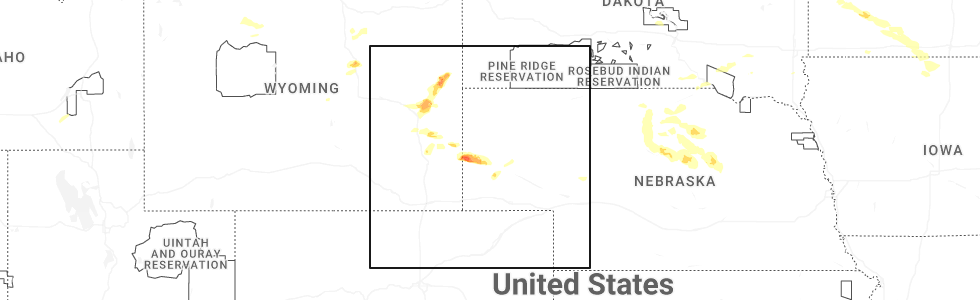
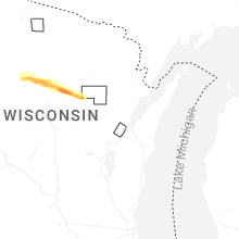
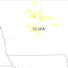
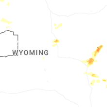
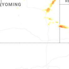
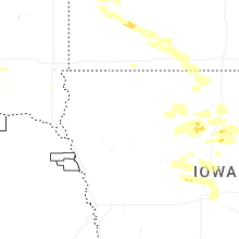
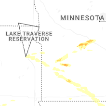
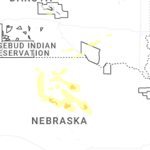
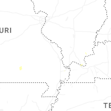
Hail Map for Friday, July 18, 2025
Number of Impacted Households on 7/18/2025
0
Impacted by 1" or Larger Hail
0
Impacted by 1.75" or Larger Hail
0
Impacted by 2.5" or Larger Hail
Square Miles of Populated Area Impacted on 7/18/2025
0
Impacted by 1" or Larger Hail
0
Impacted by 1.75" or Larger Hail
0
Impacted by 2.5" or Larger Hail
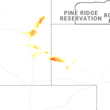


Cities Most Affected by Hail Storms of 7/18/2025
| Hail Size | Demographics of Zip Codes Affected | ||||||
|---|---|---|---|---|---|---|---|
| City | Count | Average | Largest | Pop Density | House Value | Income | Age |
| Lyman, NE | 1 | 2.00 | 2.00 | 3 | $29k | $27.0k | 40.9 |
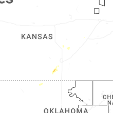
| Conway Springs, KS | 1 | 1.75 | 1.75 | 15 | $65k | $42.0k | 35.7 |
| Richmond, MN | 1 | 1.75 | 1.75 | 54 | $109k | $46.0k | 43.0 |
Hail and Wind Damage Spotted on 7/18/2025
Filter by Report Type:Hail ReportsWind Reports
States Impacted
Alabama, Virginia, North Carolina, South Carolina, Montana, Idaho, Kansas, Kentucky, Georgia, Wyoming, Nebraska, Minnesota, WisconsinAlabama
| Local Time | Report Details |
|---|---|
| 12:30 PM CDT | Tree down blocking both lanes of roadwa in jackson county AL, 47.3 miles SW of Chattanooga, TN |
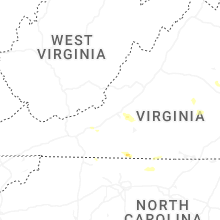
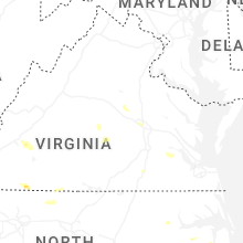
Virginia
| Local Time | Report Details |
|---|---|
| 1:40 PM EDT | Small tree down and blocking one lane near the dump at the intersection of clearview drive and arden drive in martinsville... va. time estimated from rada in henry county VA, 39 miles S of Roanoke, VA |
| 1:45 PM EDT | Two large trees down near the intersection of emerald drive and ruby court... power lines also brought down with the tree in henry county VA, 43.5 miles S of Roanoke, VA |
| 1:45 PM EDT | Tree down at a residence on irisburg road near axton... v in henry county VA, 44.1 miles S of Roanoke, VA |
| 1:55 PM EDT | Tree down along old liberty drive near the intersection at mount olive road in axton... v in henry county VA, 42.8 miles S of Roanoke, VA |
| 1:55 PM EDT | Quarter sized hail reported near Ridgeway, VA, 46.3 miles S of Roanoke, VA, report of quarter size hail near ridgeway... va. time estimated from radar. |
| 2:10 PM EDT | Tree down on power line... blocking the southbound lane of axton road near axton... v in henry county VA, 49.2 miles SSE of Roanoke, VA |
| 3:30 PM EDT | Multiple trees down... partially blocking the roadway near the intersection of franklin street and sawmill road near ferrum... va. time is estimated from rada in franklin county VA, 25.1 miles SSW of Roanoke, VA |
| 3:35 PM EDT | Tree is down on irvindale road near brookneal... va... blocking one lane of traffi in campbell county VA, 56.5 miles E of Roanoke, VA |
| 3:45 PM EDT | Quarter sized hail reported near Vinton, VA, 10.1 miles ENE of Roanoke, VA, measured hail report of quarter size north of stewartsville... va. |
| 3:50 PM EDT | Tree down on davis lane in stewartsville... v in bedford county VA, 6.1 miles E of Roanoke, VA |
| 3:50 PM EDT | Quarter sized hail reported near Goodview, VA, 8.3 miles E of Roanoke, VA, measured report of quarter size hail in stewartsville... va. |
| 3:50 PM EDT | A personal weather station reported a 60mph wind gus in bedford county VA, 8.3 miles E of Roanoke, VA |
| 3:50 PM EDT | Personal weather station measured a 62 mph wind gust near stewartsville... v in bedford county VA, 5.6 miles E of Roanoke, VA |
| 4:17 PM EDT | Tree down on the 1500 block of copper line road. time estimate in louisa county VA, 26.3 miles NNW of Richmond, VA |
| 4:17 PM EDT | Tree downed by thunderstorm winds at the intersection of whetstone road and sawmill road... and blocked the entire roa in franklin county VA, 22.3 miles SSW of Roanoke, VA |
| 4:20 PM EDT | Quarter sized hail reported near Bumpass, VA, 26.4 miles NNW of Richmond, VA, quarter size hail in locust creek. |
| 4:26 PM EDT | Tree downed by thunderstorm winds on truman hill road... and blocked the entire roa in franklin county VA, 10 miles SE of Roanoke, VA |
| 4:45 PM EDT | Tree downed by thunderstorm winds at the intersection of n river road and william f stone highway... and landed across the exit ramp and blocked the entire roa in henry county VA, 38 miles S of Roanoke, VA |
| 4:45 PM EDT | Tree downed by thunderstorm winds on philpott driv in henry county VA, 33.4 miles S of Roanoke, VA |
| 5:17 PM EDT | Tree downed by thunderstorm winds at the intersection of red house road and three creeks road... and blocked both lanes of trave in campbell county VA, 53.8 miles E of Roanoke, VA |
| 5:22 PM EDT | Tree downed by thunderstorm winds on salem roa in appomattox county VA, 57.9 miles E of Roanoke, VA |
| 5:30 PM EDT | Tree downed by thunderstorm winds near the intersection of lewis ford road and harper valley road... and blocked the roa in campbell county VA, 56.1 miles E of Roanoke, VA |
| 5:33 PM EDT | Tree downed by thunderstorm winds and landed on a powerline... that led to a power outage in the surrounding are in campbell county VA, 56.1 miles E of Roanoke, VA |
| 5:45 PM EDT | Tree limbs down near the intersection of i-64 and parham rd reported by trained spotte in henrico county VA, 9.8 miles NE of Richmond, VA |
| 5:50 PM EDT | Received numerous reports of down trees and power lines across lakeside and other parts of the count in henrico county VA, 11.9 miles NE of Richmond, VA |
| 5:50 PM EDT | Power pole snapped... lines blocking dickens rd at wilton office park near intersection w/ staples mill rd. one mature tree uprooted and two 12 inch diameter trees each in henrico county VA, 11.1 miles NE of Richmond, VA |
| 5:50 PM EDT | Corrects previous tstm wnd dmg report from 1 ese dumbarton. a large tree fell on a house along battery av in henrico county VA, 11.5 miles NE of Richmond, VA |
| 5:50 PM EDT | *** 1 inj *** a large tree fell on a house along kent street causing minor injuries to one perso in henrico county VA, 12.4 miles NE of Richmond, VA |
| 5:50 PM EDT | A large tree fell on a house along buckingham av in henrico county VA, 12 miles NE of Richmond, VA |
| 5:50 PM EDT | Corrects previous tstm wnd dmg report from 1 ese dumbarton. a large tree fell on a house along battery av in henrico county VA, 11.5 miles NE of Richmond, VA |
| 5:50 PM EDT | *** 1 inj *** a large tree fell on a house along kent street causing minor injuries to one perso in henrico county VA, 12.4 miles NE of Richmond, VA |
| 5:50 PM EDT | A large tree fell on a house along oakwood l in henrico county VA, 12.4 miles NE of Richmond, VA |
| 6:33 PM EDT | A large tree down along st james r in amelia county VA, 29.4 miles WSW of Richmond, VA |
| 6:36 PM EDT | Tree down at the intersection of amelia springs rd and 36 in amelia county VA, 28.4 miles WSW of Richmond, VA |
| 6:36 PM EDT | Tree down along route 360 near mount zion r in amelia county VA, 26.1 miles WSW of Richmond, VA |
| 6:44 PM EDT | A large tree was down along perkinson r in amelia county VA, 27.7 miles SW of Richmond, VA |
| 6:49 PM EDT | Numerous trees down along little creek r in nottoway county VA, 28.7 miles SW of Richmond, VA |
| 6:52 PM EDT | Numerous trees down along west creek r in amelia county VA, 25.9 miles SW of Richmond, VA |
| 6:53 PM EDT | Numerous trees down along namozine rd in nottawa in nottoway county VA, 28.9 miles SW of Richmond, VA |
| 6:53 PM EDT | Numerous trees down along cellar creek r in nottoway county VA, 27.5 miles SW of Richmond, VA |
| 6:55 PM EDT | Tree knocked down on us-360 in the vicinity of mount zion rd. time estimated from rada in amelia county VA, 26.6 miles WSW of Richmond, VA |
| 6:55 PM EDT | Debris on route 360 due to weather southwest of amelia courthouse. report via waz in amelia county VA, 24 miles WSW of Richmond, VA |
| 7:14 PM EDT | Numerous trees down along greenes r in amelia county VA, 17.8 miles SSW of Richmond, VA |
| 7:14 PM EDT | Numerous trees down along namozine r in amelia county VA, 17.9 miles SSW of Richmond, VA |
| 7:15 PM EDT | Tree downed and partially closing va-40 near laurel d in sussex county VA, 44.7 miles SE of Richmond, VA |
| 7:16 PM EDT | Report of 10 trees down in the proximity of blackston in nottoway county VA, 35 miles SSW of Richmond, VA |
| 7:43 PM EDT | Large tree fell down along courtney c in dinwiddie county VA, 22.3 miles SSE of Richmond, VA |
| 7:43 PM EDT | Tree knocked down along us-460 in the vicinity of courthouse rd. time estimated from rada in dinwiddie county VA, 23 miles S of Richmond, VA |
| 7:43 PM EDT | Tree knocked down along hills dr. time estimated from rada in dinwiddie county VA, 27.9 miles S of Richmond, VA |
| 7:45 PM EDT | A tree fell at the intersection of route-10 and lewis r in chesterfield county VA, 13.8 miles SE of Richmond, VA |
| 7:45 PM EDT | A large tree fell down along twin cliffs l in chesterfield county VA, 16.8 miles SE of Richmond, VA |
| 7:45 PM EDT | A large tree down at the intersection of s chester rd and millwood r in chesterfield county VA, 16.2 miles SE of Richmond, VA |
| 7:47 PM EDT | A large tree limb fell near iron bridge r in chesterfield county VA, 12.9 miles SE of Richmond, VA |
| 7:48 PM EDT | Reports of numerous trees down across southern dinwiddie county. time estimated via rada in dinwiddie county VA, 38.3 miles S of Richmond, VA |
| 7:51 PM EDT | Large tree fell down along ferndale av in city of petersburg county VA, 23 miles SSE of Richmond, VA |
| 7:54 PM EDT | Large... healthy tree fell onto an unoccupied car. time estimated from radar. report via faceboo in chesterfield county VA, 14.9 miles SE of Richmond, VA |
| 8:26 PM EDT | Multiple large tree branches fell near 46 in sussex county VA, 40.2 miles SE of Richmond, VA |
| 9:20 PM EDT | Weather station at poquoson reported a wind gust to 50 k in city of poquoson county VA, 28.4 miles NNW of Virginia Beach, VA |
| 9:20 PM EDT | A large tree fell on a house along battery av in henrico county VA, 11.5 miles NE of Richmond, VA |
| 10:02 PM EDT | Weatherflow station at third island reported a wind gust to 54 knot in anz632 county VA, 19 miles N of Virginia Beach, VA |
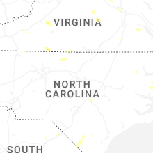
North Carolina
| Local Time | Report Details |
|---|---|
| 2:06 PM EDT | Tree down near the intersection of east pine street and slate mountain road in mount airy... n in surry county NC, 60.7 miles SSW of Roanoke, VA |
| 2:15 PM EDT | Tree down near the intersection of epperson church road and banks valley lane in mount airy... n in surry county NC, 59 miles SSW of Roanoke, VA |
| 3:00 PM EDT | Tree down blocking both lanes of travel on belvue drive in mount airy... n in surry county NC, 66.9 miles SW of Roanoke, VA |
| 5:55 PM EDT | Tree and powerline down along wheelers church road near the intersection with burlington roa in person county NC, 43.7 miles NW of Raleigh, NC |
| 6:47 PM EDT | Tree down on bunnlevel erwin r in harnett county NC, 32.5 miles S of Raleigh, NC |
| 6:51 PM EDT | Tree down at godwin-falcon rd and allie cooper r in cumberland county NC, 41.7 miles S of Raleigh, NC |
| 6:58 PM EDT | Power outage caused by fallen trees near godwi in cumberland county NC, 39.1 miles S of Raleigh, NC |
| 7:21 PM EDT | Wral on scene where eastbound lanes of i-40 were closed near mile marker 338 due to several trees down... one of which fell on a car. no injuries reporte in johnston county NC, 35.9 miles SSE of Raleigh, NC |
| 7:34 PM EDT | Power outage caused by fallen trees damaging equipment along nc-96 and keen road near four oak in johnston county NC, 27.8 miles SSE of Raleigh, NC |
| 7:55 PM EDT | Tree down near west memorial highwa in iredell county NC, 55.7 miles N of Charlotte, NC |
| 7:55 PM EDT | Tree down near west memorial highway and souther roa in iredell county NC, 55.9 miles N of Charlotte, NC |
| 7:58 PM EDT | Power line down along rosewood road near autumn winds driv in wayne county NC, 40.5 miles SE of Raleigh, NC |
| 8:01 PM EDT | Delayed report. tideland electric membership corporation reported two broken power poles and downed wire resulting in power outages. time estimated from rada in hyde county NC, 84.9 miles S of Virginia Beach, VA |
| 8:25 PM EDT | Tree downed by thunderstorm winds on nc state road 268... and blocked one side of the road... and also partially caught a powerlin in surry county NC, 74.4 miles N of Charlotte, NC |
| 8:33 PM EDT | Tree downed by thunderstorm winds near the intersection of jenkinstown road and crest rock trai in surry county NC, 74.7 miles N of Charlotte, NC |
| 8:46 PM EDT | Tree downed by thunderstorm winds... and fell on a powerlin in surry county NC, 63.9 miles SSW of Roanoke, VA |
| 8:46 PM EDT | Tree downed by thunderstorm winds... and blocking one lane... on stanford church roa in surry county NC, 73.1 miles SSW of Roanoke, VA |
| 8:48 PM EDT | Tree downed by thunderstorm winds at the intersection of beamer road and maple grove church road... and landed in the roadwa in surry county NC, 66.9 miles SW of Roanoke, VA |
| 9:00 PM EDT | Tree downed by thunderstorm winds at the intersection of jessup road and asbury roa in stokes county NC, 57.4 miles SSW of Roanoke, VA |
South Carolina
| Local Time | Report Details |
|---|---|
| 4:03 PM EDT | Tree down across portions of i-9 in dillon county SC, 86.8 miles W of Wilmington, NC |
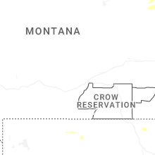
Montana
| Local Time | Report Details |
|---|---|
| 3:14 PM MDT | Time estimated by rada in beaverhead county MT, 74.6 miles ESE of Salmon, ID |
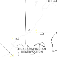
Idaho
| Local Time | Report Details |
|---|---|
| 3:14 PM MDT | Power lines damaged. power outages across the are in clark county ID, 48.7 miles NW of Idaho Falls, ID |
| 3:18 PM MDT | Power lines damaged. multiple reports of power outage in jefferson county ID, 39.9 miles NW of Idaho Falls, ID |
| 3:20 PM MDT | Pacficorp medicine lodg in clark county ID, 57.4 miles NNW of Idaho Falls, ID |
| 3:20 PM MDT | Noaa arl frd specific manufacturing capabilit in jefferson county ID, 39.2 miles NW of Idaho Falls, ID |
| 3:45 PM MDT | Noaa arl frd duboi in clark county ID, 51.1 miles N of Idaho Falls, ID |
| 4:50 PM MDT | Sheep creek hills... id (pacificor in bear lake county ID, 90.6 miles SSE of Idaho Falls, ID |
| 5:00 PM MDT | Sheep creek hills... id (pacificor in bear lake county ID, 90.6 miles SSE of Idaho Falls, ID |
| 5:42 PM MDT | Tree down on power lines. power outage in the are in teton county ID, 53 miles ENE of Idaho Falls, ID |
Kansas
| Local Time | Report Details |
|---|---|
| 4:29 PM CDT | Storm damage reported in sumner county KS, 26.4 miles SW of Wichita, KS |
| 4:35 PM CDT | Storm damage reported in sumner county KS, 26.4 miles SW of Wichita, KS |
| 4:39 PM CDT | Golf Ball sized hail reported near Conway Springs, KS, 26.4 miles SW of Wichita, KS |
| 4:57 PM CDT | Storm damage reported in sedgwick county KS, 15.2 miles SW of Wichita, KS |
| 5:03 PM CDT | Storm damage reported in sedgwick county KS, 15.5 miles SW of Wichita, KS |
| 5:15 PM CDT | Storm damage reported in sedgwick county KS, 6 miles WSW of Wichita, KS |
| 5:16 PM CDT | Delayed report. yingling aviation at eisenhower airport reported a small fedex cessna 208 caravan plane was tipped over with wing damage by thunderstorm wind gust in sedgwick county KS, 5 miles WSW of Wichita, KS |
| 5:26 PM CDT | Reported wind gust of 65mph came from a trained spotter at central and olive in sedgwick county KS, 3.1 miles E of Wichita, KS |
| 5:26 PM CDT | Nws employee reported 70mph winds at 9th and zoo blv in sedgwick county KS, 3.1 miles WNW of Wichita, KS |
| 5:29 PM CDT | Emergency management reported a tree limb blown down on a car near irma & 45th n in maiz in sedgwick county KS, 9.3 miles NW of Wichita, KS |
| 5:30 PM CDT | Nws employee reported tree damage on zoo blvd just east of i-235... part of the lane was being blocked by the downed tre in sedgwick county KS, 3.9 miles WNW of Wichita, KS |
| 5:48 PM CDT | Delayed report... large tree limb was knocked down by thunderstorm wind gust in sedgwick county KS, 7.8 miles N of Wichita, KS |
| 6:16 PM CDT | Storm damage reported in marion county KS, 35.5 miles NNE of Wichita, KS |
Kentucky
| Local Time | Report Details |
|---|---|
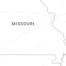
| 4:30 PM CDT | Power lines down on a firetruck at levin and park avenue in paducah. time estimated from rada in mccracken county KY, 52.2 miles ESE of Cape Girardeau, MO |
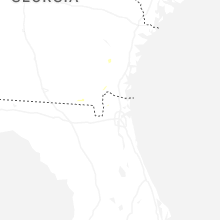
Georgia
| Local Time | Report Details |
|---|---|
| 6:08 PM EDT | Asos site at dekalb-peachtree airport (kpdk) reported a gust to 60 mph / 52 knot in dekalb county GA, 10.5 miles NNE of Atlanta, GA |
| 6:15 PM EDT | Tree down on vehicles along jimmy carter boulevard near atlantic driv in gwinnett county GA, 15.8 miles NNE of Atlanta, GA |
Wyoming
| Local Time | Report Details |
|---|---|
| 4:12 PM MDT | Mesonet station wy62 i25 us87 - smokey ga in natrona county WY, 40.2 miles N of Casper, WY |
| 6:15 PM MDT | Quarter sized hail reported near Lingle, WY, 36.8 miles WNW of Scottsbluff, NE, estimated 60 mph winds. |
| 6:21 PM MDT | Quarter sized hail reported near Shawnee, WY, 71.8 miles E of Casper, WY |
| 6:38 PM MDT | Quarter sized hail reported near Torrington, WY, 31.7 miles WNW of Scottsbluff, NE, spotter reported 1.2 inch hail 10 miles nw of henry... ne. |
| 7:25 PM MDT | Quarter sized hail reported near Torrington, WY, 22.1 miles W of Scottsbluff, NE |
| 7:25 PM MDT | Quarter sized hail reported near Torrington, WY, 22.1 miles W of Scottsbluff, NE, delayed report. broken windows reported due to wind driven quarter sized hail. time estimated via radar. |
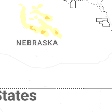
Nebraska
| Local Time | Report Details |
|---|---|
| 7:28 PM MDT | Hen Egg sized hail reported near Lyman, NE, 17.9 miles W of Scottsbluff, NE, late report from area storm chaser. |
| 7:38 PM MDT | Also received dime size hai in scotts bluff county NE, 15.3 miles W of Scottsbluff, NE |
| 7:42 PM MDT | Delayed report. outbuilding blown apart by thunderstorm winds. accompanied by pea sized hail. report received via social medi in scotts bluff county NE, 13.6 miles WSW of Scottsbluff, NE |
| 8:10 PM MDT | Ping Pong Ball sized hail reported near Gering, NE, 4.4 miles SSW of Scottsbluff, NE |
| 8:11 PM MDT | Quarter sized hail reported near Gering, NE, 2.2 miles S of Scottsbluff, NE |
| 8:13 PM MDT | Storm damage reported in scotts bluff county NE, 0.6 miles NNE of Scottsbluff, NE |
| 8:22 PM MDT | Quarter sized hail reported near Gering, NE, 7.8 miles SE of Scottsbluff, NE, estimated 65 mph wind gust. |
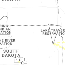
| 11:49 PM CDT | Quarter sized hail reported near Burwell, NE, 51.5 miles SSW of Oneill, NE |
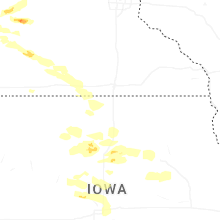
Minnesota
| Local Time | Report Details |
|---|---|
| 9:03 PM CDT | Golf Ball sized hail reported near Richmond, MN, 64.7 miles ENE of Montevideo, MN |
| 9:10 PM CDT | Quarter sized hail reported near Cold Spring, MN, 65.9 miles WNW of Minneapolis, MN, reported via stearns co em in slack. |
| 9:24 PM CDT | Quarter sized hail reported near Saint Cloud, MN, 58 miles NW of Minneapolis, MN |
| 9:35 PM CDT | Quarter sized hail reported near Saint Cloud, MN, 55.7 miles NW of Minneapolis, MN |
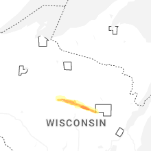
Wisconsin
| Local Time | Report Details |
|---|---|
| 5:52 AM CDT | Quarter sized hail reported near Wausau, WI, 38.6 miles S of Rhinelander, WI, report from mping: quarter (1.00 in.). |
| 6:03 AM CDT | Ping Pong Ball sized hail reported near Wausau, WI, 39.3 miles S of Rhinelander, WI |
| 6:03 AM CDT | Trees down in hewit in marathon county WI, 39.3 miles S of Rhinelander, WI |
| 6:03 AM CDT | Half Dollar sized hail reported near Wausau, WI, 39.3 miles S of Rhinelander, WI, corrects previous hail report from 6 wnw hogarty. |
| 6:06 AM CDT | Rv blown over in the town of harriso in marathon county WI, 40.9 miles S of Rhinelander, WI |
| 6:16 AM CDT | Several trees down in aniw in shawano county WI, 44.5 miles SSE of Rhinelander, WI |
Connect with Interactive Hail Maps