

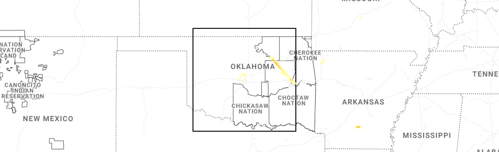
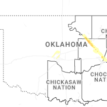
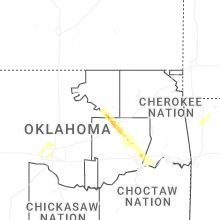
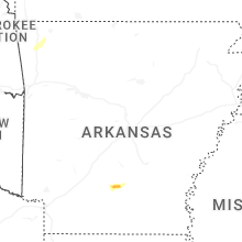
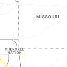
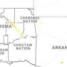
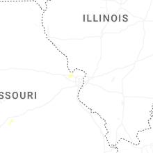
Hail Map for Saturday, October 18, 2025
Number of Impacted Households on 10/18/2025
0
Impacted by 1" or Larger Hail
0
Impacted by 1.75" or Larger Hail
0
Impacted by 2.5" or Larger Hail
Square Miles of Populated Area Impacted on 10/18/2025
0
Impacted by 1" or Larger Hail
0
Impacted by 1.75" or Larger Hail
0
Impacted by 2.5" or Larger Hail
Cities Most Affected by Hail Storms of 10/18/2025
| Hail Size | Demographics of Zip Codes Affected | ||||||
|---|---|---|---|---|---|---|---|
| City | Count | Average | Largest | Pop Density | House Value | Income | Age |
| Checotah, OK | 1 | 1.75 | 1.75 | 42 | $57k | $26.5k | 45.7 |
| Bearden, AR | 1 | 1.75 | 1.75 | 12 | $42k | $27.4k | 42.3 |
Hail and Wind Damage Spotted on 10/18/2025
Filter by Report Type:Hail ReportsWind Reports
Missouri
| Local Time | Report Details |
|---|---|
| 10:31 AM CDT | Quarter sized hail reported near Lebanon, MO, 51.3 miles W of Salem, MO, hail to the size of quarters fell southwest of dry knob. |
| 6:40 PM UTC | Tree down blocking half the roadwa in dade county MO, 22.3 miles WNW of Springfield, MO |
| 7:25 PM UTC | Tree limb blown down across live powerline... catching fir in webster county MO, 29.2 miles E of Springfield, MO |
| 3:46 PM CDT | Tree down across hwy 119 north of montauk state park entrance. time estimated by rada in dent county MO, 14.6 miles SW of Salem, MO |
Illinois
| Local Time | Report Details |
|---|---|
| 5:45 PM UTC | Tree down on merchant st. report relayed by broadcast media. time estimated by rada in effingham county IL, 25.8 miles SSW of Mattoon, IL |
| 11:26 AM UTC | Storm damage reported in white county IL, 45.1 miles WNW of Evansville, IN |
Oklahoma
| Local Time | Report Details |
|---|---|
| 5:50 PM UTC | Storm chaser on the north side of sallisaw reported a power flash and brief loss of power. also estimated thunderstorm wind gusts of 58 to 60 mp in sequoyah county OK, 22 miles WNW of Fort Smith, AR |
| 6:07 PM CDT | Quarter sized hail reported near Sand Springs, OK, 14.4 miles W of Tulsa, OK, 1 inch hail reported. |
| 6:25 PM CDT | Measured wind of 60 mph with 1/2 inch hail as wel in creek county OK, 11.6 miles SW of Tulsa, OK |
| 6:28 PM CDT | Half Dollar sized hail reported near Sapulpa, OK, 12.3 miles SSW of Tulsa, OK, public report of 1.25 inch hail. |
| 6:31 PM CDT | Quarter sized hail reported near Sapulpa, OK, 9.9 miles SSW of Tulsa, OK, public report... verified with photo. 1 inch hail. |
| 6:38 PM CDT | Half Dollar sized hail reported near Kiefer, OK, 14.9 miles SSW of Tulsa, OK, social media photo. |
| 6:44 PM CDT | Quarter sized hail reported near Glenpool, OK, 14.5 miles S of Tulsa, OK, photo of quarter size hail. |
| 6:47 PM CDT | Ping Pong Ball sized hail reported near Glenpool, OK, 15.9 miles S of Tulsa, OK, photo showing hail on social media. |
| 6:59 PM CDT | Quarter sized hail reported near Mounds, OK, 21.1 miles S of Tulsa, OK, report from mping: quarter (1.00 in.). |
| 7:00 PM CDT | Quarter size hail and 65 mph win in okmulgee county OK, 24 miles SSE of Tulsa, OK |
| 7:57 PM CDT | Golf Ball sized hail reported near Checotah, OK, 53.3 miles SSE of Tulsa, OK, golf ball hail and wind gusts to 65 mph. |
| 7:59 PM CDT | Multiple trees and power lines downed in tow in mcintosh county OK, 53.9 miles SSE of Tulsa, OK |
Texas
| Local Time | Report Details |
|---|---|
| 2:08 PM CDT | Large tree branch snapped on buffalo ru in johnson county TX, 38.6 miles WSW of Dallas, TX |
| 2:20 PM CDT | Large tree reportedly blown down in thousand oaks mobile home par in tarrant county TX, 25.3 miles WSW of Dallas, TX |
| 9:45 PM CDT | Law enforcement reported a tree down 6 miles outside of cente in shelby county TX, 49.2 miles SSW of Shreveport, LA |
Arkansas
| Local Time | Report Details |
|---|---|
| 3:20 PM CDT | Trees blocking ar 29 north of lewisville. time estimated by rada in lafayette county AR, 36.7 miles SSE of Nashville, AR |
| 4:54 PM CDT | Golf Ball sized hail reported near Bearden, AR, 68.1 miles SSW of Little Rock, AR, report received via social media. |
Indiana
| Local Time | Report Details |
|---|---|
| 8:30 PM UTC | Powerlines downed with a measured 50 mph gust in the are in la porte county IN, 54.7 miles SE of Chicago, IL |
Louisiana
| Local Time | Report Details |
|---|---|
| 4:23 PM CDT | Law enforcement reports trees and powerlines down just north of man in sabine county LA, 60 miles SSE of Shreveport, LA |
| 4:41 PM CDT | Local law enforcement reports trees and powerlines dow in de soto county LA, 33.8 miles S of Shreveport, LA |
| 4:45 PM CDT | Local law enforcement reports trees and powerlines dow in de soto county LA, 30.2 miles S of Shreveport, LA |
| 4:53 PM CDT | Law enforcement reports trees down north of coushatt in red river county LA, 40.5 miles SE of Shreveport, LA |
| 5:01 PM CDT | Trees down reported by law enforcemen in union county LA, 30.6 miles WSW of Bastrop, LA |
| 5:14 PM CDT | Law enforcement report trees and powerlines dow in bienville county LA, 38.4 miles ESE of Shreveport, LA |
| 5:35 PM CDT | Law enforcement report trees and powerlines dow in bienville county LA, 40.8 miles E of Shreveport, LA |
| 6:00 PM CDT | Trees down in and around homer... reported by law enforcemen in claiborne county LA, 44.3 miles ENE of Shreveport, LA |
| 6:05 PM CDT | Trees down reported by law enforcemen in lincoln county LA, 43.7 miles W of Bastrop, LA |
Michigan
| Local Time | Report Details |
|---|---|
| 10:27 PM UTC | Station kir in st. joseph county MI, 53.7 miles NNW of Fort Wayne, IN |
Connect with Interactive Hail Maps